Ascent Passport
-
Class of snow and ice ascents.
-
Teskey-Ala-Too, Jety-Oguz gorge.
-
Peak 2nd Western Oguz-Bashi (5000 m) via the north wall.
-
Proposed 5B category of difficulty, first ascent.
-
Height difference 1050 m. Length 1205 m. Length of sections with 5-6 category of difficulty is 745 m. Average steepness of the main part of the route is 61°, including III category of difficulty: 95° — 5 m, 35° — 120 m.
-
16 rock pitons hammered, 174 ice placements.
-
Team's travel time is 16 hours, 1 day.
-
ONE Overnight stay ON A ROCK-ICE PLATFORM.
-
Leader: Leontiev Vadim Gennadievich — Master of Sports.
Participants:
- Serpak Alexander Alexandrovich — Master of Sports
- Alperin Vladimir Maevich — Candidate Master of Sports
- Poznyakov Viktor Olegovich — Candidate Master of Sports
-
Coach: Sviridenko Vadim Sergeevich — Honored Coach of the Ukrainian SSR.
-
Approach to the route on August 13, 1984. Summit — August 13, 1984, return — August 14, 1984.
-
Organization: Central Council of the "Trud" Sports Society — Odessa Regional Council of the "Avangard" Sports Society — "Trud".
Cartographic diagram of the axial part of the Teskey-Alatau ridge in the upper reaches of the Jety-Oguz river.
Scale: 1 cm — 1 km.

Sheet 3
Tactical Actions of the Team
The rationale for choosing the ascent route to peak 2nd West Oguz-Bashi via the north wall and developing the tactics for the first ascent were based on the following main considerations:
- Reliability, integrity, and safety of the route;
- The predominantly icy nature of the route, including an ice wall about 600 m high and diverse ice relief such as "tire calina", crevices, and a frozen waterfall on a rocky bastion, which allowed the team to employ the arsenal of modern high-level ice climbing techniques;
- The route's length is sufficient for a 5B category of difficulty;
- Presence of possible bivouac locations in the upper part of the route in case of sudden weather deterioration during the ascent.
Equipment to support the tactical plan:
- Ice screws with original hook sharpening.
- Ice axes made of thickened material (based on the 1983 championship results) and with special sharpening.
- Spiked crampons (VCSPS) and self-made (similar to foreign models).
- Limited but diverse set of rock pitons.
Cable equipment: a "Pamirka" tent, a primus stove with fuel, sleeping bags, and ice axes not only guaranteed the team a quality rest but also made them capable of providing assistance in case of emergencies.
The departure for the route between 1:00 and 2:30 was due to temporary weather deterioration. At 1:30, the team was at the start of the technical part of the route. When moving in pairs along the left slab (section R2-R3), the first pair's pitons were used by the second pair. The practiced technique of passing used pitons ensured a high speed of passage (30 minutes for one rope length for two pairs). Section R3-R4 was climbed via rocks to the left, 10 m away from the planned route, due to a thin layer of ice on the rocks along the planned trajectory. Section R4-R6 was climbed via an ice waterfall using ice axes and feet. Section R5-R6 was climbed slightly to the right of the planned route (up to 7 m) due to numerous icicles that were not safe for the participants. The route on section R3-R6 was climbed by all participants except the first one with top-rope belay. Sections R6-R7 (ice ridge), R7-R8 (ice couloir), R8-R9 (ice slope-slab) were climbed using a similar technical technique as sections R0-R3. Section R9-R10 was climbed using fixed ropes due to numerous "live rocks" on the slope. Section R10-R11 (pre-summit ridge) was climbed simultaneously with piton belay, and a bivouac site was chosen. On the route, the following participants worked ahead: R0-R1 — Alperin, R1-R4 — Poznyakov, R4-R5 — Leontiev, R5-R6 — Poznyakov, R6-R8 — Leontiev, R8-R9 — Poznyakov, R9-R11 — Alperin. A short rest, tea, and food were taken at 11:00 at point 3. At point 6, a bivouac was possible (an ice platform carved out). Descent. During the ascent, the group found that descending via the "Silver Saddle" (alternative route) was less labor-intensive. This decision was communicated to the observer via evening radio at 20:00. The descent from the summit began at 9:00 on August 14, 1984, after the visibility improved. The descent from the "Silver Saddle" pass was carried out following the tracks of previous teams. At 12:30, the team was near the assault camp. Communication with the observer was constant during the ascent. Additionally, the observer could see the team on the route through binoculars during brief periods of improved visibility.
Route diagram in symbols.
Pitons — 190 pcs. Number of pitches. Hours — 16.
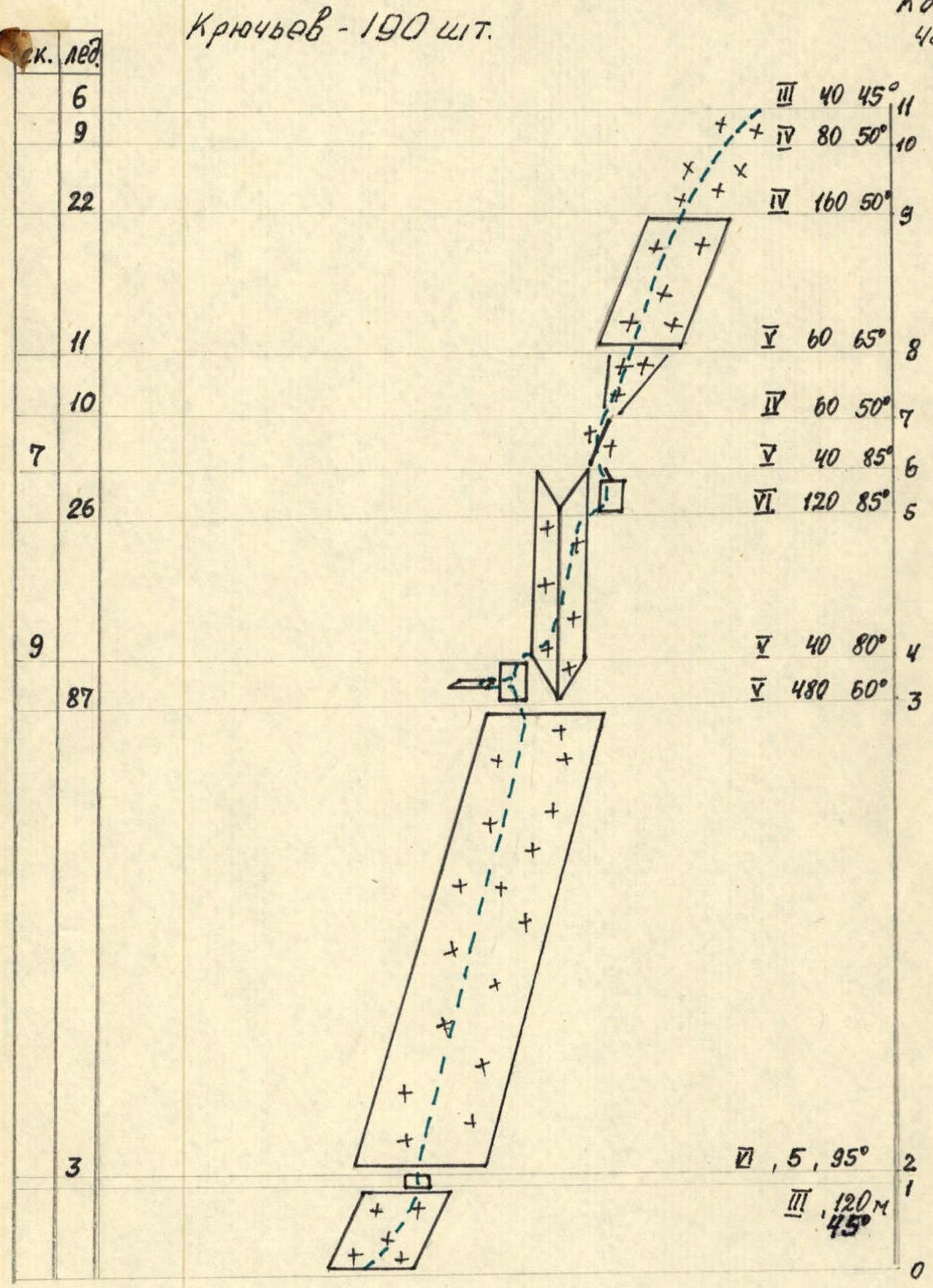
Scale 1:5000
Description of the Route by Sections
Section R0-R1 is a snow-ice slope with a steepness of 45°. Length 120 m. Simultaneous movement. Belay via ice axe.
Section R1-R2 is the upper wall of a snow-filled bergschrund. Wall height 5 m, steepness 95°. Climbed using ice axes and feet. Alternating movement.
Section R2-R3 Ice wall with a length of 480 m, steepness 60°. Climbed with ice axe and ice screws, and feet. Movement in pairs: the second pair uses the first pair's pitons.
Section R3-R4 Lower part of a frozen waterfall in an inner corner. Due to thin ice in the lower part, it is bypassed via the left wall of the inner corner. Steepness 80°, length 40 m.
Section R4-R5 Middle part of the frozen waterfall. Steep cascades of powerful ice up to 7 m wide. Climbed using ice axes and feet. Section length 120 m, steepness 85°.
Section R5-R6 In the upper part of the waterfall, the continuity of ice cascades is disrupted, and climbing individual hanging ice cascades becomes unsafe. Bypass via rocks to the right of the waterfall, length 40 m, steepness 85°. The rocks lead to an ice triangle.
Section R6-R7 Ice triangle with a steepness of 50°, length 60 m. Climbed on front crampons and ice axe. The triangle narrows at the top and transitions into a groove.
Section R7-R8 Groove with a steepness of 65°, width at the top — 3 m, length 60 m, climbed on front crampons, ice axe, and ice screws, and feet.
Section R8-R9 is an ice slope with a steepness of 50°, length 180 m. At the top, the slope is bounded by a snow ridge where belaying is difficult due to a thick layer of loose snow. Therefore, the section is climbed on ice 5 m below the ridge, on front crampons and ice axe.
Section R9-R10 Ice slope with a steepness of 50°, length 80 m, and numerous rock outcrops of various sizes. Presence of "live rocks". The section is climbed via ice between rocks.
Section R10-R11 The ascent to the summit is an ice-snow slope with a steepness of 45°, length 40 m. Movement on front crampons. Belay via ice screws, clearing the top snow layer by 20 cm.