Ascent Passport
- Ascent class — snow-ice
- Ascent area, ridge — Central Tien Shan, Terskey Ala-Too ridge, Baytor gorge
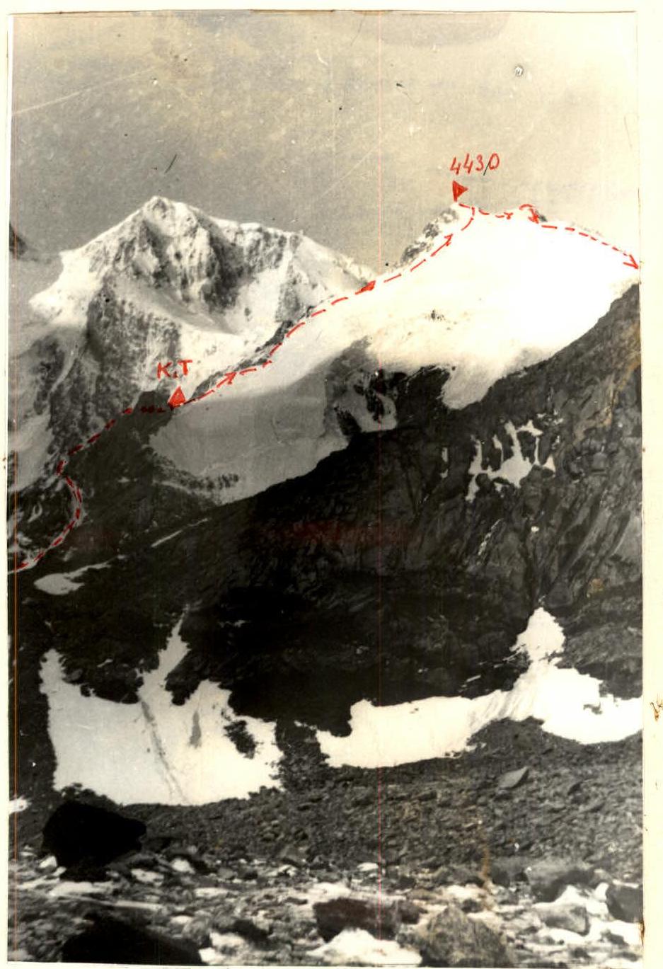
- Peak, its height, ascent route — p. 4430 (named after Keldysh) via the eastern edge
- Proposed category of difficulty — 4A
- Route characteristics: height difference — 775 m, length of sections with 5–6 category of difficulty — 160 m, average steepness — 45°
- Driven protection hooks:
| Rock | 6 |
|---|---|
| Ice | 16 |
| Nut | 2 |
- Number of travel hours — 14
- Number of overnight stays and their characteristics — none
- Full name of the leader, participants and their qualification: Leader: Solovey V. A. — 1st category Participants: Melibashev M. A. — 1st category Shangaraev A. M. — 1st category Kanashkina L. S. — 2nd category
- Team coach — Melibashev M. A.
- Date of departure and return: July 21, 1985 — July 21, 1985
- Organization — Omsk Regional Sports Committee, Alpinism Federation
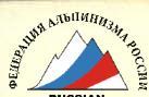
Map-scheme of the axial part of the Terskey Ala-Too ridge in the upper reaches of the Dzhety-Oguz river
Brief description of the approach to the route
Peak 4430 (named after Keldysh according to the note on the peak) is located at the beginning of the Northern spur of the main Terskey Ala-Too ridge and is clearly visible against the background of p. Neil Armstrong (4909) from the assault camp site at the fork of the Baytor gorge, to which the following path must be taken.
From Przhevalsk, drive by car to the Dzhety-Oguz resort and further along the road to the Telety gorge (12 km from the resort).
Then, from the last (tenth) bridge, a pedestrian transition begins up the Dzhety-Oguz gorge (to the south) along the right (orographic) bank of the eponymous river to the fork to the Baytor gorge (2–2.5 hours). From the confluence, we continue to climb along the same bank of the river to the crossing (300 m, logs), cross to the other bank and move in the direction of the Baytor river.
Not far from the confluence, there is a crossing (logs) over which we cross to the left (orographic) bank of the Baytor river and follow the horse trail along this bank to the fork of the Baytor gorge.
Opposite the steeply breaking end of the dividing spur, there is a good grassy site for organizing an assault camp. Thus, the approach takes 5–6 hours from the Telety gorge with full backpacks.
From the Baytor camp, we move along the right (orographic) moraine, leaving the "Ailama" pass to the right, then along the glacier tongue, overcoming the steep ice "forehead" of the glacier, we approach the beginning of the route — the Eastern edge (2 hours from the camp).
Brief description of the route
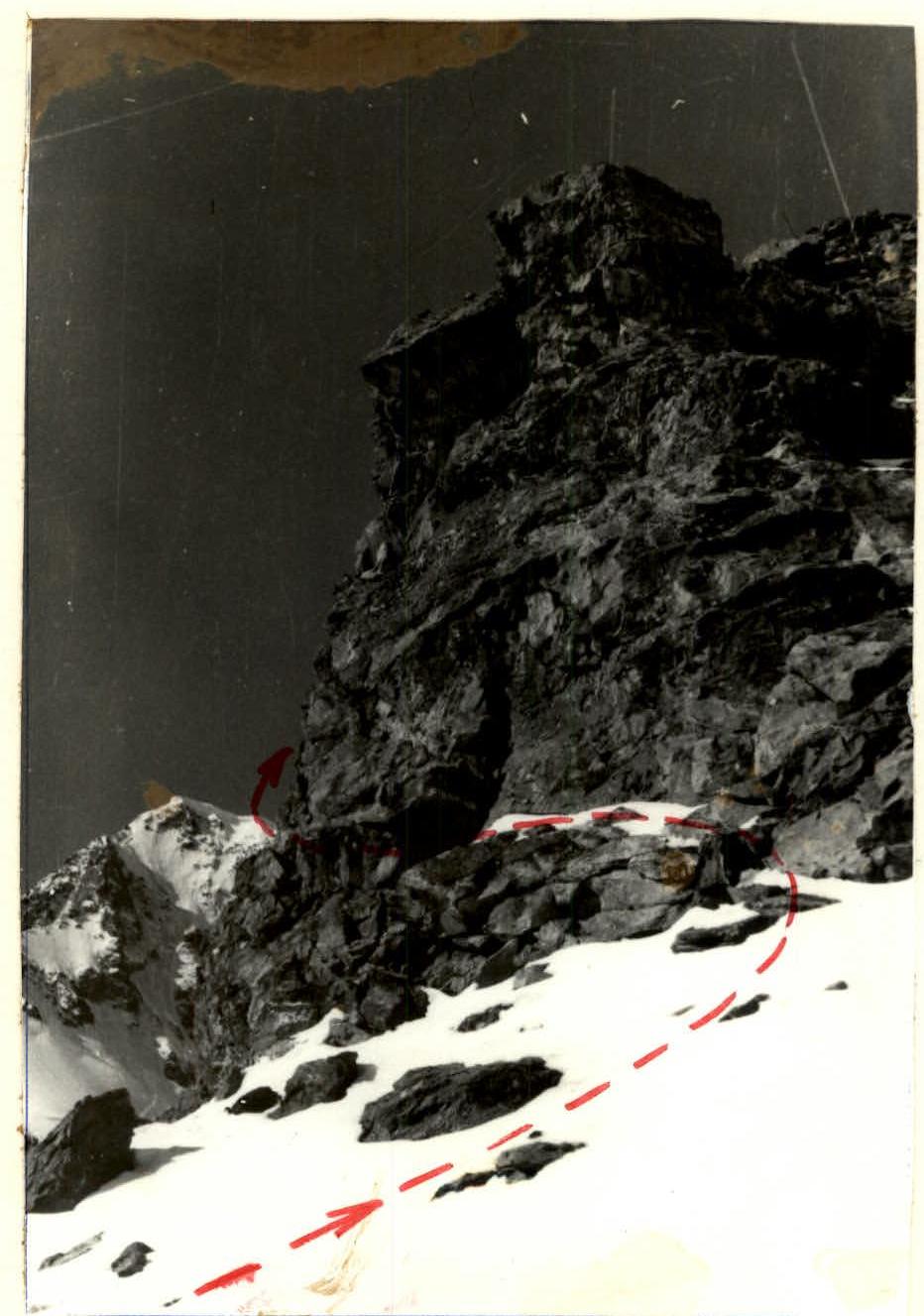
Along wide destroyed shelves (section R1), adhering to the slopes of the eastern edge, exit to the lowering in the ridge (wide rock shelf), to the right — a "gendarme". Control cairn. It is recommended to pass this part of the route before 8:00, as later it is prone to rockfall!
Further, 80 m along a wide snowy edge, leaving the destroyed rocky slopes to the left with an exit to the scree shelves (section R2). Then another 80 m to the second characteristic rock on the slope (second "gendarme"). It is bypassed on the left along the shelves to the second snowy ascent (insurance is alternate).
Further, 80 m of steep snow with ice (section R3), insurance through ice screws to a snowy saddle — a col (interaction of rope teams).
Then a steep ice ascent with a thin layer of snow on top (section R4). The snow holds poorly. Insurance is alternate through ice screws. In the upper part of the route, the steepness of the ice increases even more to 60°–65° (sections R5–R7).
Exit to the Northern ridge, then to the summit. Descent to the north along the route of 4A category of difficulty to the "Ailama" pass and further to the assault camp.
July 20, 85
Characteristics of the route sections
| Section | Average steepness | Length (m) | Terrain characteristics | Difficulty | State | Weather conditions | Rock hooks | Ice hooks |
|---|---|---|---|---|---|---|---|---|
| R1 | 40° | 30 | Inclined and vertical ridge slabs with shelves | 2 | On the ridge, there is flow ice. On the shelves, there are loose rocks | Good | 2 | - |
| R2 | 70° | 10 | Inner corner | 4 | At the top, there are loose rocks with ice | - | 4 | - |
| R3 | 35°–40° | 80 | Ridge slabs. Vertical monolith, gendarmes | 2 | Large stones are frozen | - | 1 | - |
| R4 | 50° | 60 | Inclined shelf | 2 | - | 3 | - | |
| R5 | 70° | 80 | Inclined shelf. Inner corner | 4 | In crevices, there is ice | - | 4 | - |
| R6 | 20° | 40 | Inclined slabs | 1 | Snow | - | - | - |
| R7 | 35° | 40 | Large-block ridge slabs | 2 | Snow on the slabs | - | - | - |
| R8 | 35°–40° | 80 | Snowy and rocky slope | 2 | Loose rocks | - | - | - |
| R9 | 50° | 30 | Inner corner | 4 | Flow ice | - | 2 | - |
| R10 | 20° | 60 | Rock tower (descent) | 2 | - | - | - | |
| R11 | 10° | 20 | Snow-ice col | 2 | Firn | - | - | - |
| R12 | 35°–45° | 100 | Wall. Inclined shelves | 2 | Loose rocks | - | 2 | - |
 |