
Ascent Passport
-
Ascent class — high-altitude and technical.
-
Ascent area — Central Tian Shan, Tengri Tagh ridge.
-
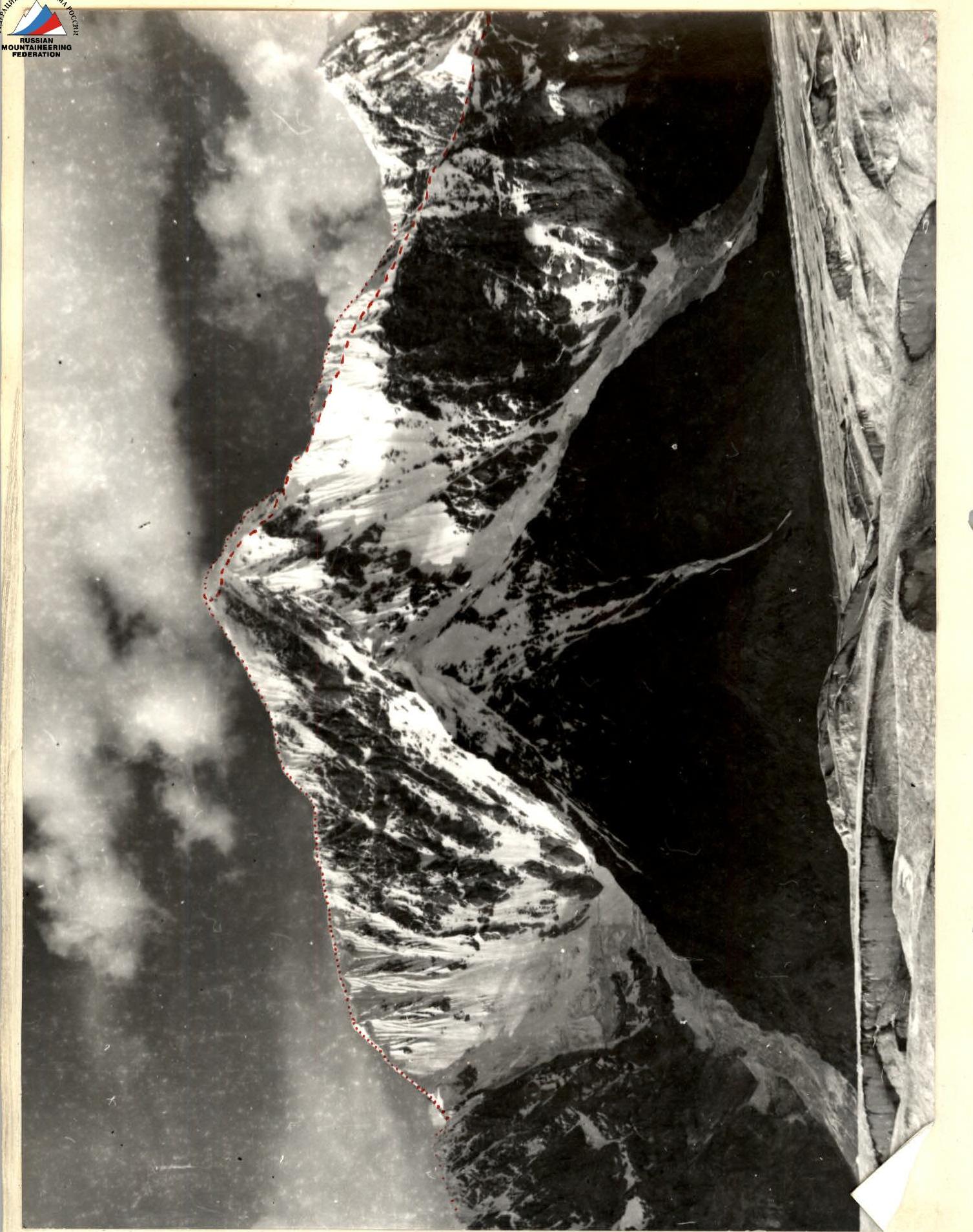
Peak, its height, ascent route — Peak Chapayev, 6371.0 m, via the Southeast ridge.
-
Estimated difficulty category — 5B.
-
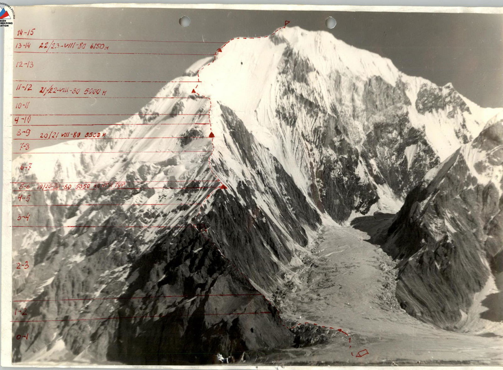
Route characteristics: height difference 2200 m.
Section lengths: 5th difficulty category — 810 m. 6th difficulty category — 65 m. Average steepness of the rocky part of the route — 60°, snowy-icy part — 42°.
-
Number of pitons used for belaying: rock — 42 ice — 94 bolt — none for creating artificial protection: rock — none ice — 4 bolt — none
-
Number of climbing hours: 60 hours.
-
Number of bivouacs — 5. Their characteristics:
lying — 5. On platforms carved in a snowy-icy slope — 4. Trampled on a snowy slope — 1.
-
Surname, name, patronymic of the leader, participants and their qualification:
- Onin Alexander Alexandrovich — CMS (Candidate for Master of Sports), leader
- Kim Timofey Shimaevich — CMS, participant
- Potashov Alexander Ivanovich — 1st sports category, participant
- Shibkov Pyotr Filippovich — 1st sports category, participant
-
Team coach: Biryukov Vladimir Nikolaevich, CMS, 1st category instructor.
-
Date of departure on the route — August 19, 1980, return — August 24, 1980.
Legend:
PREVIOUSLY CLIMBED ROUTES TEAM'S ROUTE
Information about reconnaissance and supply trips
The "Spartak" Sports Society expedition was delivered to the South Inylchek glacier by helicopter from the city of Przhevalsk. On August 16, after descending from Khan-Tengri peak and a week's resturging, a reconnaissance group comprising Onin A.A., Kim T.Sh., Potashov A.I., Shibkov P.F., and Alabushchev V. set out under Peak Chapayev. The result of this trip was the establishment of a storm camp on the South Inylchek glacier (near the confluence with the Semenovsky glacier). This location was the most optimal as it was a safe spot for observers with a clear view of the southeast ridge of Peak Chapayev, particularly its initial rocky section. Through binoculars, the entire visible part of the snowy-icy ridge was carefully examined. Particular attention was paid to the state of the precarious hanging snow cornices in the second half of the day. The necessary equipment and supplies were left at the storm camp. The group returned to the base camp in the evening.
Brief description of the approach to the route
Peak Chapayev, with a height of 6371.0 m, is located in the eastern part of the Tengri Tagh ridge, which divides the Inylchek glacier into northern and southern branches. Peak Chapayev is situated between the absolute marks of 5881.0 m to the west (Peak E. Abalakova) and Peak 6120.0 m to the east. The ascent began from the base camp, located on the right-bank moraine of the South Inylchek glacier under the slopes of Peak M. Gorky. The path from the base camp to the storm camp, established under the southern end of the SE ridge of Peak Chapayev, along the South Inylchek glacier, takes 2–2.5 hours. The approach to the route from the storm camp takes 30–40 minutes. Most of the time is spent overcoming numerous crevices formed at the confluence of the Semenovsky and South Inylchek glaciers.
Composition of the observation group
The team was observed by groups of the following composition: from August 19 to 22, 1980.
- Otchik V.K. — CMS
- Musienko V.V. — CMS
From August 22 to 24, 1980, the observation and meeting group consisted of:
- Duiko V.I. — CMS
- Vodopyanov S.K. — CMS
- Samokhvalov A.V. — CMS.
Tactics of the ascent
The tactics of this ascent were determined by the nature of the route and the specific meteorological conditions of Central Tian Shan. The extremely high avalanche danger, frequent snow slab falls, and spontaneous cornice collapses from the snowy-icy ridge forced the group to move with extreme caution and thorough belaying after noon, significantly slowing their pace. Thus, the most reasonable tactic under these conditions was to cover as much of the route as possible in the morning. For this, the group departed on the route no later than 8:00 after each bivouac, despite the strong cold in the early hours. An earlier departure was not feasible. The final third of the route was traversed in severe weather conditions (hurricane-force winds, snowfall), which greatly hindered early departures, but the arrangement of bivouacs in "high-altitude" type tents for four people somewhat facilitated quick morning preparations and helped the group stick to their schedule.
During the ascent, the first climber proceeded with a very light backpack or without one. The second climber in the first rope team also carried a minimal load. On particularly difficult and dangerous sections, such as when cutting through large cornices, a double rope was used. All participants used "harness" type belts. Some ice pitons with a special slot made it easier to remove frozen ice crumbs from the piton. Even a small number of such pitons provided a significant effect when working on the route, especially in severe cold. This tactic allowed the group to make the most of the daylight for route preparation and maximize safety, which was key to a successful ascent.
Notes from the summit and control tour on the route
The team, making the first ascent of the Southeast ridge of Peak Chapayev, left a note in the control tour. The control tour was left at the site of the first bivouac on the eastern counterfort, 50 m below the ridge shoulder.
Copy of the note from the control tour
August 20, 1980. The team of the Kyrgyz "Spartak" Sports Society in composition:
- Onin A.A. — leader
- Kim T.Sh. — participant
- Potashov A.I. — participant
- Shibkov P.F. — participant
participating in the 1980 Central Council "Spartak" Sports Society Championship, is ascending Peak Chapayev via the E-E ridge. Everything is fine in the team. The weather is deteriorating. Strong wind. Greetings to the next climbers. Onin.
Copy of the note left on the summit
August 23, 1980, 11:30. The team of the Kyrgyz "Spartak" Sports Society in composition:
- Onin A.A. — leader
- Kim T.Sh. — participant
- Potashov A.I. — participant
- Shibkov P.F. — participant
participating in the 1980 Central Council "Spartak" Sports Society Championship, has completed the ascent of Peak Chapayev (height 6371.0 m) via the E-E ridge (first ascent), approximately 5B difficulty category.
A note from the Belarusian climbers dated August 1, 1980, was retrieved: Everything is fine in the team. The team started the route from the storm camp on the South Inylchek glacier on August 19, 1980. The group intends to descend via the 5A category route to the saddle between Peak Chapayev and Khan-Tengri. The weather is awful. Gusty winds and cold. It's snowing. Visibility is limited to a rope length.
Greetings to the next climbers. Onin.
Copy of the note retrieved from the summit
August 1, 1980, 10:00. The group of climbers from the Belarusian Council of the "Spartak" Sports Society in composition:
- Dvura B.P. — leader
- Lovaev E.M.
- Solovey O.M.
- Karpenko F.M.
- Otchik V.K.
- Ustinkin V.V.
completed the ascent of Peak Chapayev via the counterfort of the southern wall, 5B difficulty category (first ascent). Departed from camp on July 26. The weather is sunny. Frost. We will descend to the saddle between Peak Chapayev and Khan-Tengri. Greetings to the next climbers.
Note: The note retrieved from the tour by the Belarusian climbers was heavily dampened, and the lines were significantly blurred. Therefore, possible distortions in the surnames of some team members.
Brief explanation of the table
The entire route can be schematically divided into four parts:
- Lower, rocky part.
- Snowy-icy corniced ridge.
- Counterfort.
- Summit ridge.
| Section | Length (m) | Height difference (m) | Average steepness (degrees) | Interval of absolute heights (m) |
|---|---|---|---|---|
| 1. Lower part | 820 | 790 | 70° | 4150–5120 |
| 2. Snowy-icy ridge | 2320 | 980 | 42° | 5120–6100 |
| 3. Counterfort | 300 | 150 | 60° | 6100–6250 |
| 4. Summit ridge | 340 | 120 | 45° | 6250–6371 |
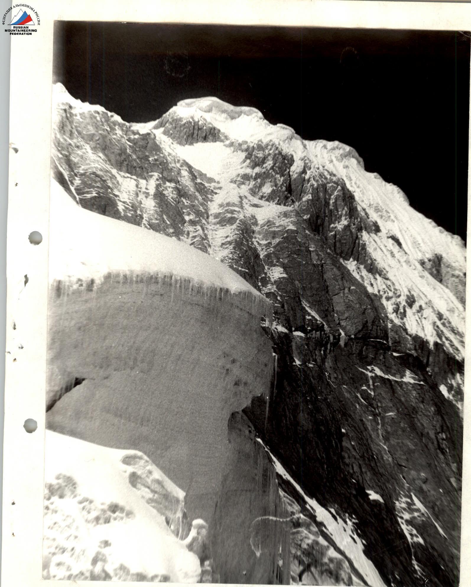
The lower rocky part of the route is characterized by strongly destroyed rocks composed of schists and marbleized limestones. Sections composed of schists are colored gray or light gray, while limestone sections are typically colored yellow-brown.
The seventy-degree wall (section R1–R2), leading to the rocky ridge, is the most rockfall-prone. The wall is composed of strongly destroyed, very slippery schist slabs facing downwards, with a layer of completely destroyed small slabs on top. These slabs crack and slide underfoot, turning into "stone rain." There are no suitable ledges on this section; belaying is done using pitons. The ridge itself is composed of strongly destroyed rocks. Small smooth limestone slabs covered in ice and small gullies are encountered.
The descent from the first pinnacle is done via a rappel, 25–28 m (section R2–R3). The rocks are very destroyed and rockfall-prone. After the first pinnacle, the ridge widens enough to set up a tent and bivouac.
After the second pinnacle, there is a twenty-meter very steep (over 70°) ice-filled couloir ending in an internal angle (section R3–R4). The rocks are less destroyed, composed of limestone blocks. Piton belaying combined with belaying through ledges is very reliable. The entire rocky section is closed by a huge snowy-icy overhanging cornice, which is cut through "en face" and leads to the snowy-icy part of the ridge.
The snowy-icy ridge is characterized by snowy-icy aжурные cornices hanging to the northeast along its entire length. Crossing the very sharp (sometimes no more than 5 cm wide) snowy-icy ridge is a difficult psychological task, and overcoming huge overhanging cornices, which are key sections, requires maximum mental and physical strain. This section of the route is composed of re-frozen, frost-like, very loose snow and extremely brittle, cavernous ice. Sharp sections of the ridge and small cornices are traversed by traversing the western slope of the ridge, one and a half to two meters below the edge of the cornice, for maximum safety. Snow underfoot hardly compresses into steps, and prolonged trampling significantly increases the already high avalanche danger. In very brittle, cavernous ice, there are very few places for belaying, and when a solid spot is found, it is often necessary to chop through 30–40 cm of brittle, frost-like ice. Large overhanging cornices are overcome "en face." The steepness of individual cornices sometimes reaches 110°–115° (sections R6–R7, R10–R11, R11–R12), and the extraordinary fragility of this "cornice mass" does not allow the use of artificial points of support. Cutting through cornices consumes the maximum amount of climbing time, sometimes taking 4–5 hours per rope length. Deteriorating weather conditions, especially fog and snowfall, greatly complicate the passage of these sections. In fog, cornices appear smoothed, merging with the surrounding environment, making it difficult to determine a safe distance from the edge. During and after snowfall, there is spontaneous collapse of overloaded cornices, and avalanche danger increases several times.
The counterfort is characterized by heavily snow-covered rocky sections. Many internal angles filled with ice and snow are encountered. In the lower part of the counterfort, the rocks are mostly destroyed, composed of limestones; colors range from bright rust to brown. Some sections covered with rime ice appear as if frozen through; steel pitons do not hold in such places; ice pitons shatter everything around them into small pieces when driven in; the use of titanium profiled pitons like "korobochka" provides the greatest effectiveness and reliability. The upper part of the counterfort is composed of large-block limestones of dark gray color. The rocks are of medium difficulty, heavily snow-covered. Small sections composed of eльска (a type of rock) are encountered. Organizing reliable belaying is not complicated due to the abundance of reliable ledges and cracks. The greatest difficulty is overcoming small but heavily snow-covered internal angles. These angles are composed of very smooth rock slabs with smoothed and ice-covered holds. Deep loose snow complicates the passage of such places.
The summit ridge initially consists of destroyed, snow-covered rocks of medium difficulty, then transitions into a sharp snowy-icy section with overhanging cornices (section R14–R15). Before the summit, it transforms into a wide snowy slope with a steepness of 40°–45°, with some rocky sections protruding. The snow is extremely loose and deep, with thicknesses reaching over a meter in some places. The highest point is dome-shaped, heavily snow-covered, with unclear rocky sections.
MAP OF THE UPPER REACHES OF THE SOUTH INYLCHEK GLACIER
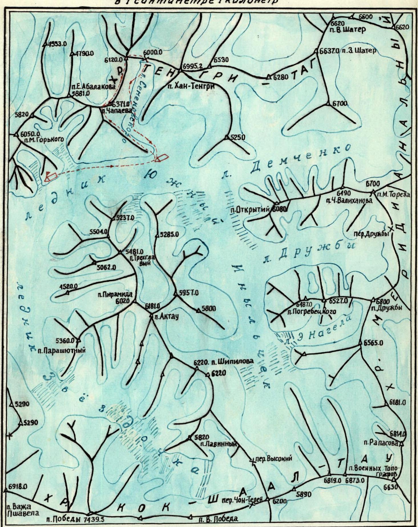
LEGEND
storm group route base camp storm camp
Route evaluation and recommendations for passage
The significant length of the route — about four kilometers — and the height difference (over 2 km), along with the presence of sections of high difficulty category at absolute heights of 5000–6000 m, allow us to consider that the route deserves a classification of 5B difficulty category. For the passage of this route, the team considers a group of 4 people to be the most optimal. Such a group will be more mobile, which is very important for ensuring safety when passing complex snowy-icy sections with overhanging cornices. The entire route is characterized by very high avalanche danger, with constant snow slab falls from the snowy-icy ridge. Therefore, when working on the route in the second half of the day, maximum caution and thorough belaying are required.
The team considers the classification of the 5A category route, by which the descent from the summit was made, to be underestimated. The descent proceeded along a sharp snowy-icy corniced ridge, with sections of 5–6 difficulty category. According to the participants, this route can be classified as 5B category.
Information about team preparation
This team, participating in the Central Council "Spartak" Sports Society Championship, was formed on the basis of representatives from two collectives: the Alpinism Section at the Kyrgyz Republican Council, represented by Onin A.A., Potashov A.I., Shibkov P.F., and the Alpinism Section of the Belarusian "Spartak" Sports Society — represented by Kim T.Sh.
All team members conducted OPF (General Physical Preparation) and rock climbing training during the off-season. During the May 1980 alpinad, ascents of 3rd and 4th difficulty categories were made.
In addition, all team members, along with other climbers, made an ascent of Peak Khan-Tengri via the southwest slope, 5B category, a week before ascending Peak Chapayev. For the needs of the Main Directorate of Geodesy and Cartography under the Council of Ministers of the USSR, the climbers installed and mounted a geodetic triangulation point on Peak Khan-Tengri. This ascent was significantly complicated, but the team members received excellent training and acclimatization. It is worth noting that in the previous season of 1979, all participants completed one or more ascents of 5B category.
Table of main ascent characteristics
| Date | Section | Average steepness (degrees) | Length (m) | Terrain character | Difficulty | Condition | Weather conditions | Rock pitons | Ice pitons | Bolt pitons |
|---|---|---|---|---|---|---|---|---|---|---|
| 19.08.1980 | R0–R1 | 45 | 150 | Talus slope | 2 | Ice, talus | Clear | Simultaneous | ||
| R1–R2 | 75 | 70 | Rock wall | 5 | Strongly destroyed rocks | 4 | ||||
| R2–R3 | 45 | 25 | Rocky ridge | 2 | 6 | |||||
| 80 | 40 | Rocky wall, pinnacle | 4 | 2, 4/3 ledges | ||||||
| 45 | 200 | Rocky ridge | 10 | |||||||
| 60–65 | 45 | Rocky wall, pinnacle | 4 | 4 | ||||||
| R3–R4 | 80 | 20 | Rocky-icy couloir | Ice-filled rocks | Overcast | 3 | ||||
| 55 | 80 | Rocky ridge | Snow-covered rocks | 2, 4/3 ledges | ||||||
| R4–R5 | 65 | 60 | Snowy-icy slope | Deep loose snow, brittle ice | 3, 4/3 ice axe | |||||
| R5–R6 | 55 | 100 | Snowy-icy slope | 5 | ||||||
| 11 |
Departure time — 5:00. Stop for bivouac — 19:00. Climbing hours — 13. Night's stay lying on a platform carved in an icy slope.
| Date | Section | Average steepness (degrees) | Length (m) | Terrain character | Difficulty | Condition | Weather conditions | Rock pitons | Ice pitons | Bolt pitons |
|---|---|---|---|---|---|---|---|---|---|---|
| 20.08.1980 | R6–R7 | 30 | 250 | Very sharp snowy-icy ridge with hanging cornices | Overcast, snow | 21, 4/3 ice axe | ||||
| 50 | 60 | 8 | ||||||||
| 100–110 | 30 | Hanging snowy-icy cornice | 6 | Frost-like snow, cavernous brittle ice | Fog, snow, wind | 4, digging trenches | ||||
| 30 | 60 | Snowy-rocky-icy slope | Snow-covered, ice-covered rocks | 2 | 4/3 ice axe, ledges | |||||
| R7–R8 | 50 | 40 | Snowy-icy ridge | 4 | Deep loose snow, ice | 4 ice axes | ||||
| R8–R9 | 30–35 | 260 | Snowy ridge | Deep fresh snow | ||||||
| 50–55 | 120 | Snowy-icy ascent | Very deep loose snow, ice | 4/3 ice axe | ||||||
| 40 | 80 | Firn slope | Dense firn |
Departure time — 7:00. Stop for bivouac — 19:00. Climbing hours — 11. Bivouac conditions remain the same.
| Date | Section | Average steepness (degrees) | Length (m) | Terrain character | Difficulty | Condition | Weather conditions | Rock pitons | Ice pitons | Bolt pitons |
|---|---|---|---|---|---|---|---|---|---|---|
| 21.08.1980 | R9–R10 | 45–50 | 240 | Sharp snowy-icy slope with hanging cornices | Loose snow, brittle ice | Overcast | 15, 4/3 ice axe | |||
| R10–R11 | 70–75 | 50 | Snowy-icy wall | Very loose snow, brittle ice | Wind | 6, cutting steps | ||||
| 110–115 | 25 | Hanging snowy-icy cornice | Very brittle ice, loose snow | Cold, snow | 3, cutting through cornice | |||||
| 35–40 | 150 | Snowy-icy slope | 3 | Avalanche-prone, loose snow | 4/3 ice axe | |||||
| 70–75 | 50 | Strong wind, snow | 4/3 ice axe, cutting inclined trenches | |||||||
| R11–R12 | 30–35 | 150 | Snowy-icy ridge with hanging cornices | Brittle ice, loose snow | 4/3 ice axe | |||||
| 20–25 | 100 | Wide snowy ridge | 2 | Deep snow | Simultaneous 4/3 ice axe |
Departure time on the route — 7:40. Stop for bivouac — 18:15. Climbing hours — 10. Night's stay lying on a snowy platform.
| Date | Section | Average steepness (degrees) | Length (m) | Terrain character | Difficulty | Condition | Weather conditions | Rock pitons | Ice pitons | Bolt pitons |
|---|---|---|---|---|---|---|---|---|---|---|
| 22.08.1980 | R12–R13 | 30 | 80 | Snowy-firn slope | Hard firn | Clear, wind | 4/3 ice axe and simultaneous | |||
| 75–80 | 150 | Snowy-icy wall | Brittle ice, deep snow 0.4–0.5 m | Cloudy, wind | 15, 4/3 ice axe | |||||
| 40–45 | 300 | Firn-snowy-icy slope | 5 | Thin firn, deep 1–1.2 m snow, brittle ice | 6, 4/3 ice axe | |||||
| 30 | 80 | Firn slope with isolated rocks | Firn, outcrops of destroyed rocks | Strong wind, fog, snow | Simultaneous and 4/3 ice axe, ledges | |||||
| R13–R14 | 65–70 | 70 | Rocky-snowy-icy counterfort | Destroyed, ice-filled, snow-covered rocks | 2 | 3, 4/3 ledges | ||||
| 45–50 | 150 | Snowy-rocky ridge | Snow-covered rocks | Wind, heavy snowfall | 9 | 4/3 ledges |
Departure time on the route — 7:30. Stop for bivouac — 18:30. Climbing hours — 10. Night's stay lying on a platform carved in an icy slope.
| Date | Section | Average steepness (degrees) | Length (m) | Terrain character | Difficulty | Condition | Weather conditions | Rock pitons | Ice pitons | Bolt pitons |
|---|---|---|---|---|---|---|---|---|---|---|
| 23.08.1980 | R14–R15 | 45–50 | 40 | Snow-covered rocky ridge | Snow-covered rock slabs | Hurricane-force wind, snow | 4/3 ledges | |||
| 20–26 | 140 | Sharp snowy-icy ridge with hanging cornices | Deep fresh snow, brittle ice | 4, 4/3 ice axe | ||||||
| 40–45 | 160 | Wide summit ridge | Very deep 1–1.2 m loose snow | Simultaneous, 4/3 ice axe |
Ascent to the summit and descent from it.
Departure time — 8:00. Stop for bivouac — 20:00. Climbing hours — 11. Bivouac conditions remain the same.
24.08.1980. Departure time — 8:00. Descended to the Semenovsky glacier at 13:40. Weather is clear. Frost.
TOTAL PITONS DRIVEN ON THE ROUTE FOR BELAYING: Rock pitons — 42 Ice — 94 For creating artificial protection: Rock — none Ice — 4
Comments
Sign in to leave a comment