
Ascent Record
-
Region — Central Tien-Shan, Tengri-Tag ridge, September 7, 1918
-
Peak — Khan-Tengri 6995 m, via SW facet of SW edge (V. Sviridenko)
-
Complexity category — 6B
-
Route type — combined
-
Route characteristics: elevation gain — 2395 m, elevation gain of the wall section — 1450 m, route length — 3455 m, length of sections with 6th category difficulty — 170 m, 5th category — 700 m, average steepness: wall section — 60°, entire route — 50°.
-
Pitons left on the route: total — 0. Pitons used on the route: stationary bolted — 1* (left previously), including mechanical protection — 0; removable bolted — 0. Total mechanical protection used — 6.
-
Total climbing hours — 88, days — 8.
-
Team leader — Aidar G. Akhmadiev, Candidate for Master of Sports
Team members:
- Konstantin N. Kabanov, 1st sports category
- Rasim G. Kashapov, 1st sports category — up to the marble edge (6500 m)
- Yuri I. Kruglov, Candidate for Master of Sports — up to the marble edge (6500 m)
-
Team coach: Valery S. Kudryashov, Candidate for Master of Sports, 1st sports category
-
Approach to the route — August 7, 2003, at 6:00 Summit attainment — August 14, 2003, at 16:00 Return to Base Camp — August 15, 2003, at 3:00
-
Organization: Ministry of Youth and Sports of the Republic of Tatarstan

General view of the summit. (August 14, 2003, South Inylchek glacier, 4000 m elevation, Rolley camera)
- team's route via SW facet of SW edge, 6B category (V. Sviridenko)
- route via left part of SW facet and SW edge, 5B category (B. Romanova)
- route via South wall, 6A category (G. Isachenko)
- descent route from the summit
- descent route of the pair Kruglov — Kashapov
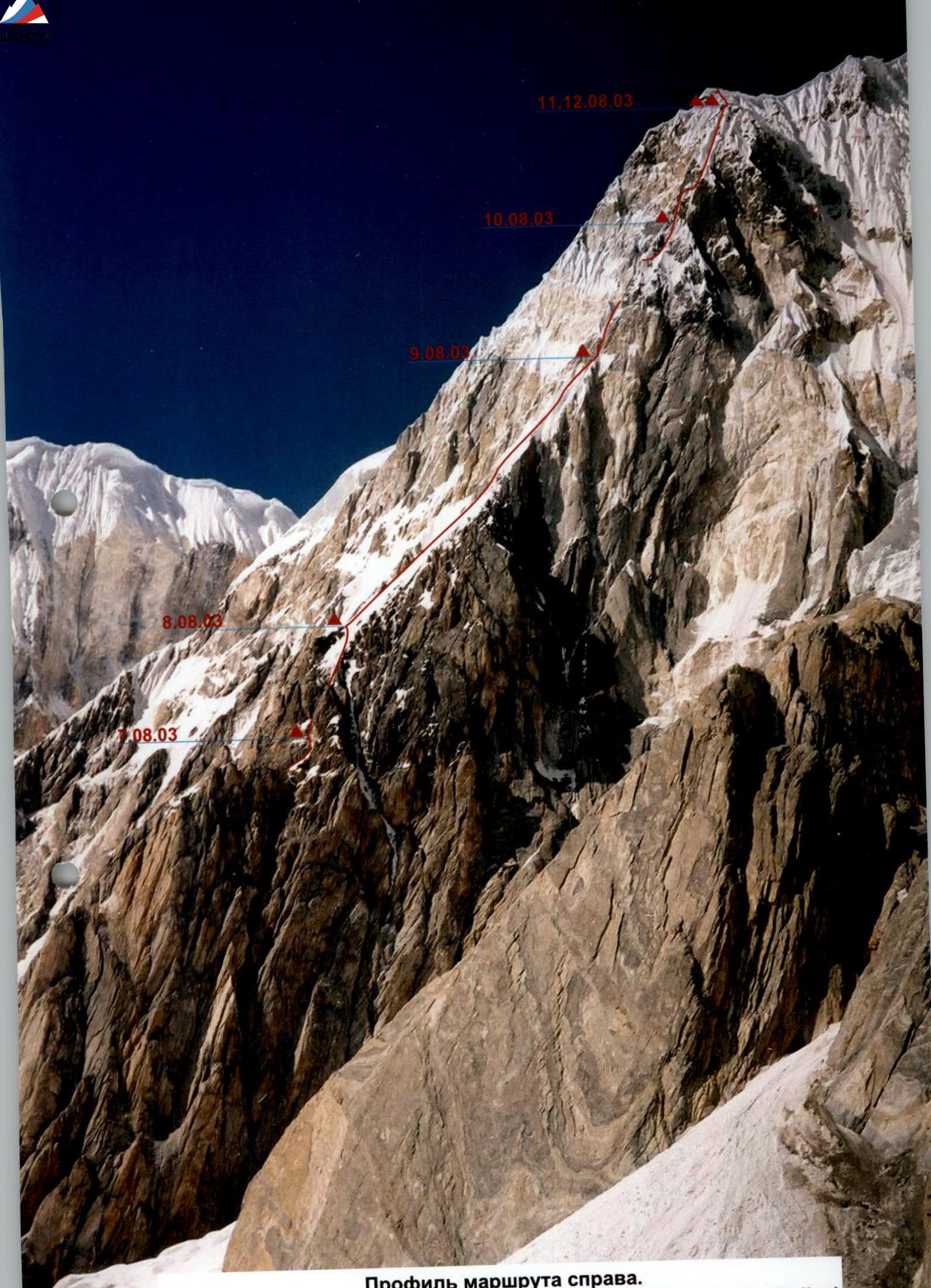
Route profile from the right. (August 9, 2003, glacier under Jolantoo peak, 4300 m elevation, Rolley camera)
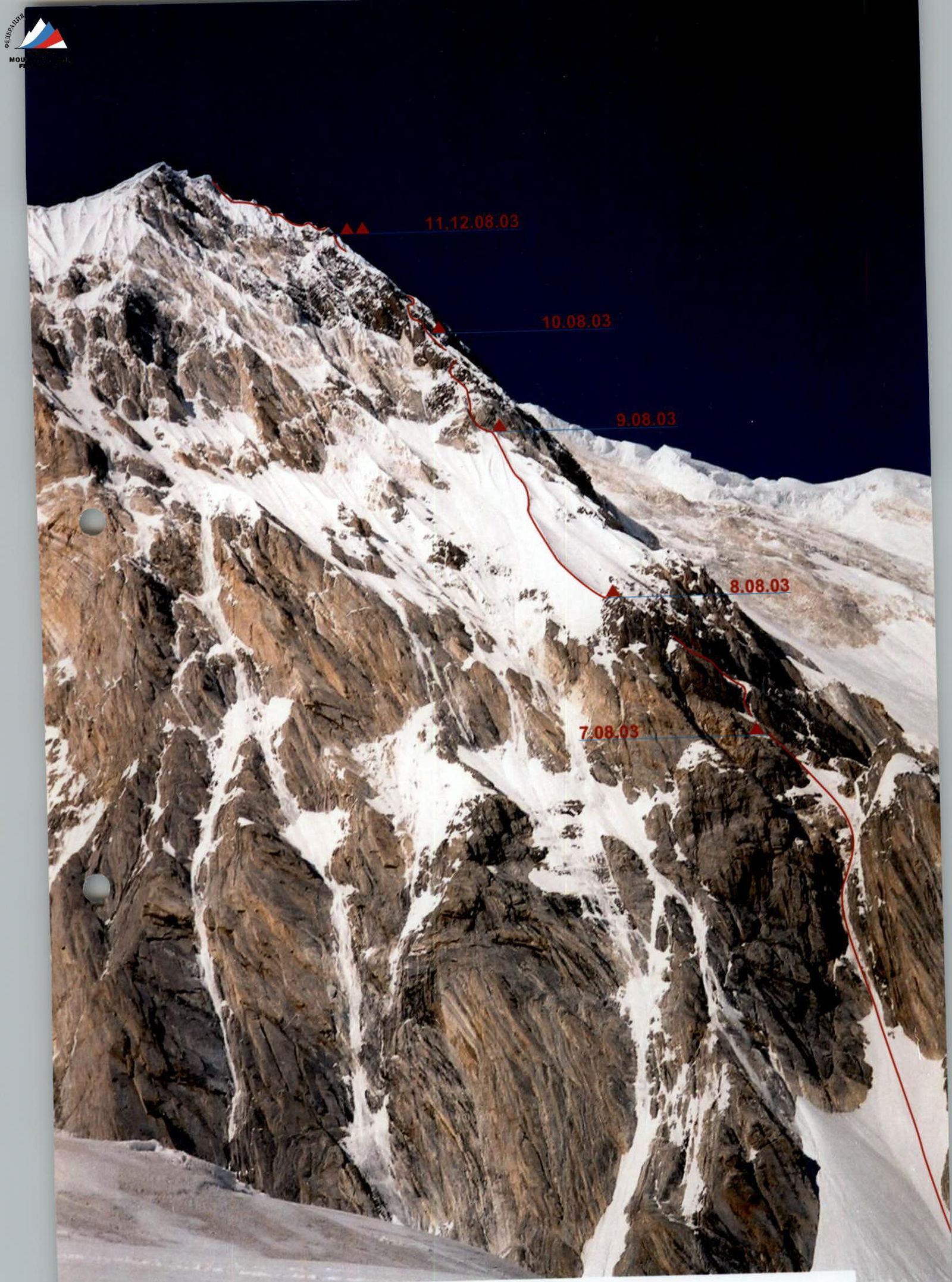
Route profile from the left. (August 9, 2003, Semenovsky glacier, 4700 m elevation, Rolley camera)
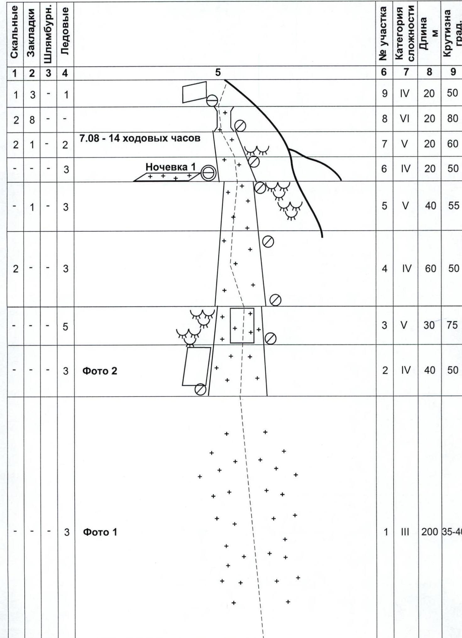
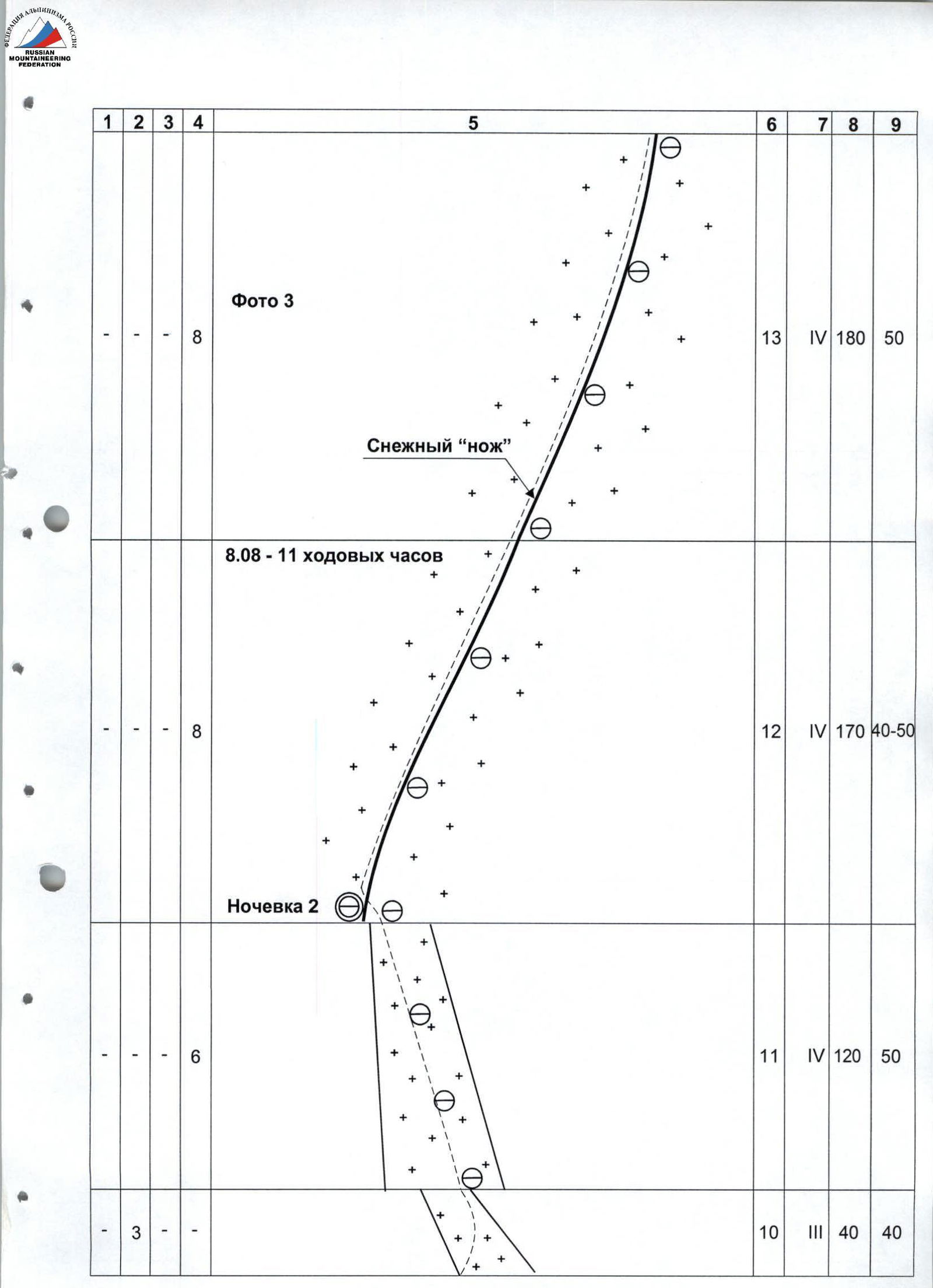
Route diagram in UIAA symbols
| Rock | Chocks | Bolts | Ice | 5 | Section # | Difficulty category | Length, m | Steepness, degrees |
|---|---|---|---|---|---|---|---|---|
| - | - | - | 3 | Photo 1 | 1 | III | 200 | 35–40 |
| - | - | - | 3 | Photo 2 | 2 | IV | 40 | 50 |
| - | - | - | 5 | (diagram) | 3 | V | 30 | 75 |
| 2 | - | - | 3 | (diagram) | 4 | IV | 60 | 50 |
| - | 1 | - | 3 | (diagram) | 5 | V | 40 | 55 |
| - | - | - | 3 | Overnight 1 | 6 | IV | 20 | 50 |
| 2 | 1 | - | 2 | August 7 — 14 climbing hours | 7 | V | 20 | 60 |
| 2 | 8 | - | - | (diagram) | 8 | VI | 20 | 80 |
| 1 | 3 | - | 1 | (diagram) | 9 | IV | 20 | 50 |
| 3 | - | - | - | (diagram) | 10 | III | 40 | 40 |
| - | - | - | 6 | Overnight 2 | 11 | IV | 120 | 50 |
| - | - | 8 | Snow "knife", August 8 — 11 climbing hours | 12 | IV | 170 | 40–50 | |
| - | - | - | 8 | Photo 3 | 13 | IV | 180 | 50 |
| - | - | - | 6 | Photo 4 | 14 | V | 110 | 70 |
| 2 | 2 | - | - |  | 15 | V | 10 | 80 |
| 2/1 | 5/1 | - | - | 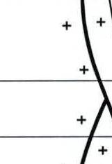 Overnight 3 Overnight 3 | 16 | VI A2 | 10 | 90 |
| - | 3 | - | - | August 9 — 12 climbing hours | 17 | V | 10 | 70 |
| - | 1 | 1 | - |  | 18 | IV | 15 | 60 |
| - | - | - | 2 |  | 19 | IV | 15 | 65 |
| 1 | - | 3 | - | Photo 5 | 20 | IV | 20 | 60 |
| - | 3 | - | 1 |  | 21 | IV | 30 | 65 |
| - | 2 | - | - |  | 22 | V | 15 | 70 |
| 2 | - | 3 | - | 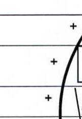 | 23 | VI | 20 | 90 |
| - | 2 | - | - |  | 24 | VI | 15 | 90 |
| - | - | - | - |  | 25 | IV | 15 | 60 |
| - | - | - | 2 |  | 26 | V | 15 | 65 |
| - | 1 | 1 | 1 | 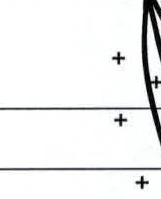 | 27 | V | 30 | 65 |
| 1 | - | - | 1 | Photo 6 | 28 | V | 10 | 70 |
| - | 2 | 2 | - |  | 29 | VI | 25 | 90 |
| 4 | 1 | - | 1 | August 10 — 14 climbing hours | 30 | V | 45 | 70 |
| 2 | - | - | - | 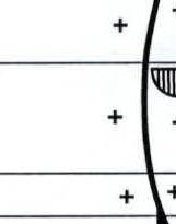 | 31 | VI | 20 | 80 |
| 2 | 6 | - | - | 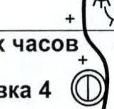 | 32 | VI | 20 | 80 |
| 4 | 12/4 | - | 2 | 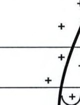 | 33 | VI A1 | 40 | 80 |
| - | - | - | 2 |  Traverse Traverse | 34 | V | 25 | 75 |
| 1* | 2 | - | - | Photo 7 | 35 | V | 20 | 70 |
| - | - | - | 4 | (diagram) | 36 | IV | 100 | 50 |
| - | - | - | 4 | August 11 — 13 climbing hours | 37 | V | 100 | 70 |
| 3 | - | - | - | Overnights 4,5; August 12 — 12 climbing hours | 38 | V | 10 | 80 |
| - | - | - | - | Triangle peak | 39 | V | 210 | 50–70 |
| - | - | - | - | Overnight 7; Gendarme; Photo 10; August 13 — 13 climbing hours | 40 | II | 460 | 35–40 |
| 10 | 38 | - | - | Summit; Photo 11; August 14 — 11 climbing hours | 41 | III–IV | 1080 | 40–45 |
Route description by sections
August 7, 2003, started at 6:00. First working pair is Kruglov — Akhmadiev.
Section 1. Simultaneous movement along a snow-ice couloir. Loose snow in the lower, more gentle part gives way to thin ice with rock outcrops. In the upper part, the couloir becomes steeper. The first climber uses an ice axe and ice tool. It's snowing.
Section 2. Snow-ice couloir with thin, loose ice layer, under which there's a void 20–30 cm and rocks beneath.
Section 3. Ice wall. Passage with ice axe and "fifi". Steep, wet, and loose ice. Unreliable protection. Ice screws are used. Heavy snowfall, visibility is minimal. Dry snow avalanches periodically come down on us from above, significantly hindering movement.
Sections 4–7. Passage of these sections is also accompanied by dry avalanches. Couloir with outcrops of destroyed rocks, filled with ice. After processing a narrow 20-meter couloir leading to an ice-filled chimney, the Kruglov — Akhmadiev pair descends one rope length down, where the second pair, after a lengthy search, finds a place to bivouac. They have to dig and, in some places, cut out a platform in the ice necessary for setting up a tent.
August 8, 2003, departure at 8:00. First working pair is Akhmadiev — Kruglov.
Section 8. Chimney filled with ice. The ice is loose and unreliable. Due to the complexity of setting up protection within the chimney, the pair passes along the left side on rocks. Difficult climbing.
Sections 9–11. Passage along a snow-ice couloir with very loose snow to the start of the "snow knife". Forced pause — we wait for the Kiev team led by Strelnikov, who descended the "knife" four days earlier and abandoned further ascent. Setting up an overnight camp; the weather worsens, and it starts snowing.
Section 12. After the Kiev team's descent, the Akhmadiev — Kruglov pair passes 170 m of the "knife" and descends down, hanging a rope. Protection on the "knife" is only possible after clearing a half-meter layer of snow down to the ice. The weather deteriorates significantly. Snow, visibility 30–40 m.
Technical photograph of the route. (July 29, 2003, Semenovsky glacier, 4300 m, Zenit-122 camera, F–58 mm lens)
August 9, 2003, departure at 7:30. First working pair is Kashapov — Kabanov.
Sections 13–15. In the upper part, the steepness of the "knife" increases. Specially made snow anchors are used. The snow is very loose. Ice for protection lies at a depth of 1–2 m and is not always present.
Section 16. Ahead are rocks starting with a complex chimney. Difficult climbing. The chimney is filled with snow. One has to clear the snow cover first, which clings to the vertical wall, and then move forward.
Section 17. Icy and snow-covered rocks; the first climber breaks a trail and shovels away snowdrifts up to a meter deep to reach the rock relief or solid ice. Overnight on the top of the "knife" under the chimney.
August 10, 2003, departure at 6:00. Kabanov — Kashapov lead.
Section 18. Rocks covered with deep, loose snow. Under the snow is porous ice. Not very difficult climbing on rock outcrops, preceded by extensive snow clearing with a shovel. Many rock outcrops are "live" large stones.
Section 19. Snow ridge. Deep snow — waist-deep. To increase the area of support, one works standing on knees, using a shovel. On the other side, the ridge is steeper. Under the snow is fragile, porous ice.
Section 20. Up and to the right under a rock wall. Clearing cracks from snow and wet ice with a shovel and ice hammer.
Sections 21–22. Left and up along a couloir. Snow is loose and not deep. Ice is porous and layered. Between ice and rocks, there's an air gap. Protection on rock outcrops. Preliminary clearing with a shovel under ice screws. Movement is aided by "fifi" and hammer.
Section 23. Climbing is complex and determined. Relief is covered with snow. Much wet ice. At the end of the wall, there's an excellent ledge for a loop.
Section 24. Almost all climbing is determined and on balance. Relief is poor, but there are good footholds. Rocks are covered with snow. местами — wet ice.
Section 25. Steep snow ridges. Snow is loose and waist-deep. Passage is made possible using a shovel. Between them, a trench is dug. Protection is problematic.
Section 26. Wall composed of vertically stacked slabs. Cracks are blind or filled with wet ice. Passaged in the lower part. Protection is difficult.
Sections 27–28. Couloir is passaged on the left side. Snow is knee-deep. Underneath is porous ice. Protection on rock outcrops on the left. Preliminary clearing with a shovel from snow and ice.
Section 29. Center of the wall. Climbing is complex and determined. Relief is poor. Much wet ice. Snow in places. Protection is very problematic. Preliminary clearing of cracks from ice.
Section 30. In the couloir, ice is porous and layered. Protection on rock outcrops and ice screws. Preliminary clearing of significant areas from snow and loose ice. Passaged with the aid of "fifi" and hammer.
Section 31. Right of the "ram's foreheads" up the wall. Climbing is complex and determined. Rocks alternate with snow and ice. Between ice and rocks, there's an air gap. Passaged with the aid of "fifi" and ice hammer.
Overnight is set up on a rocky ridge, where a platform slightly over 1 m² is dug out in a snowdrift.
August 11, 2003, departure at 7:00. Kruglov — Akhmadiev lead.
Sections 32–33. "Black rocks" filled with ice and covered with snow. Initially, it's very problematic to set up protection, but then gaps appear where stoppers and friends fit well.
Sections 34–35. Traverse along the wall to the right — into an ice couloir, in the upper part of which a bolted piton from the first ascent team is driven. Meeting at this point with the Kuzbass team (led by A. Foigt), who started the route after us.
Sections 36–37. Ascent into a 200-meter snow-ice groove. Movement on ice axes. Protection on ice screws.
Section 38. The couloir ends in a rock wall, which is one side of a sharp "cornice" rocky ridge, completely covered with snow and snow cornices, resembling "mushrooms" in shape. Overnight on one of the "mushrooms" located slightly lower on the ridge from the exit point.
August 12, 2003, departure at 7:30. Due to the impossibility of parallel movement by both teams, a decision is made to ascend the cornice ridge together. The Kuzbass team starts first.
Section 39. After descending into a couloir on the other side of the ridge, we start to bypass the first "mushroom". An attempt to pass this section on "fifis" fails due to porous ice. The first climber in the team is "armed" with a snow shovel and, digging a trench practically above their head, moves upward. Protection on ice screws and snow anchors is unreliable due to loose snow and porous ice.
There's a change of leader in the first team. The remaining day is worked by the Akhmadiev (Tatarstan) — Foigt (Kuzbass) pair. Forward movement is only possible with the aid of a snow shovel and repeated trampling of snow in the dug-out trench. 2.5 rope lengths are covered in a day. Protection is set up using snow anchors, ice axes, and occasionally ice screws. Overnight at the previous location.
August 13, 2003, departure at 7:00. The Kuzbass team leads.
By digging trenches in the cornice ridge and breaking through some "mushrooms", both teams reach the "triangle" peak by 17:00.
Section 40. Simultaneous movement through deep snow to the base of the first "sickle" of Khan-Tengri's marble edge. Overnight under a gendarme.
August 14, 2003, departure at 5:00.
Section 41. Along a firn slope, we approach the first "sickle". Bypassing the first sickle on the left along a snow-ice slope.
On August 15 at 8:00, a helicopter is scheduled for the evacuation of our Base Camp. On August 16, early in the morning, we are to depart from Bishkek. To make it to the helicopter on time, we make a psychologically difficult decision — to split into two pairs: Kruglov — Kashapov, with unnecessary equipment for the "sickles", descend down the snow fields to the Semenovsky glacier, while the Akhmadiev — Kabanov pair, traveling light, completes the ascent.
Using ice axes on smooth, snow-covered slabs, we reach the upper part of the first "sickle" under the base of the second. Further movement is simultaneous with the organization of intermediate protection points. In some places, alternate protection is organized.
Summit attainment at 16:00. Descent along the familiar classic route to the 5900 m saddle and further down the Semenovsky glacier. On August 15, 2003, at 3:00, the team descends to Base Camp.
Photo 1. Section 1
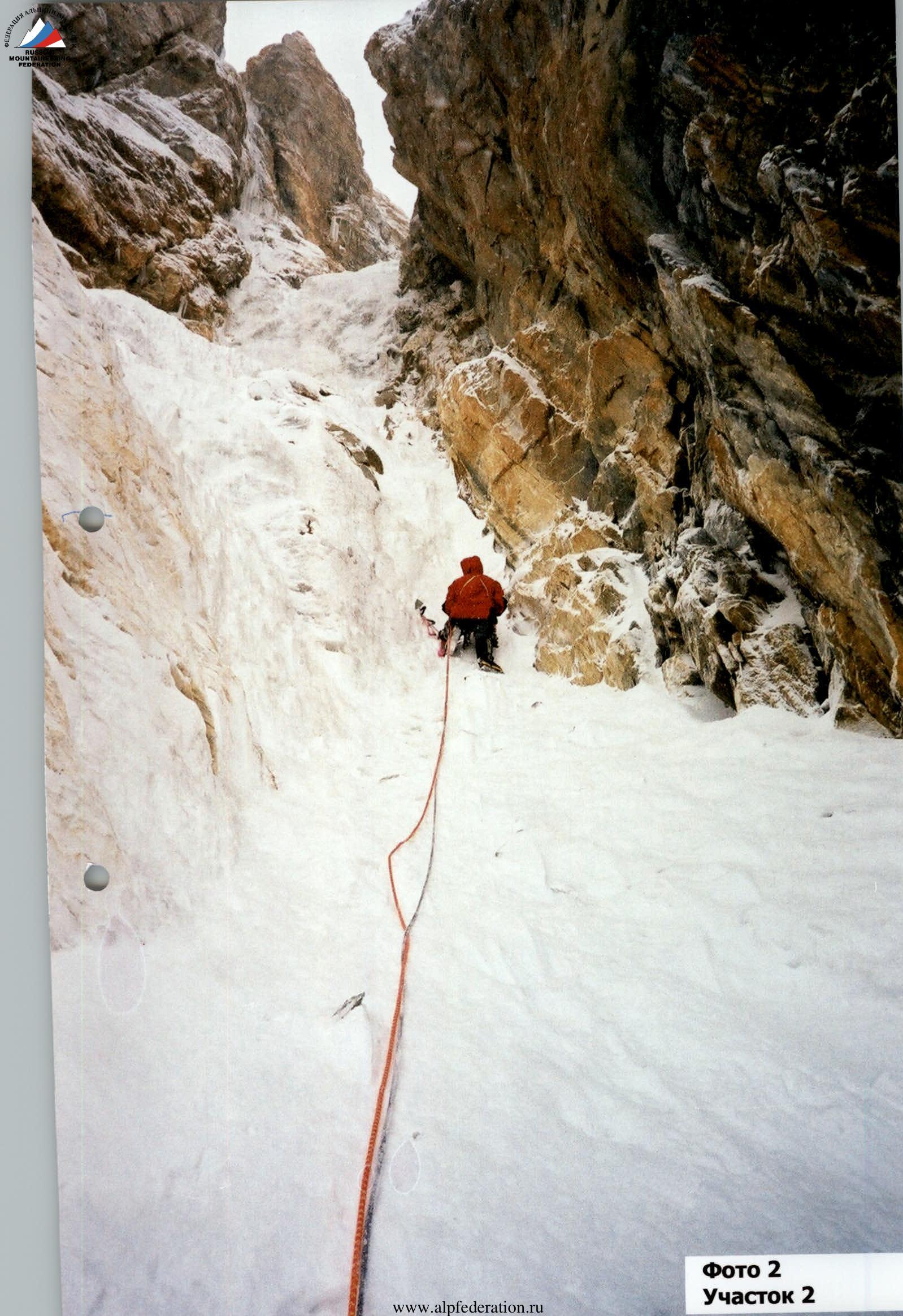
Photo 2. Section 2
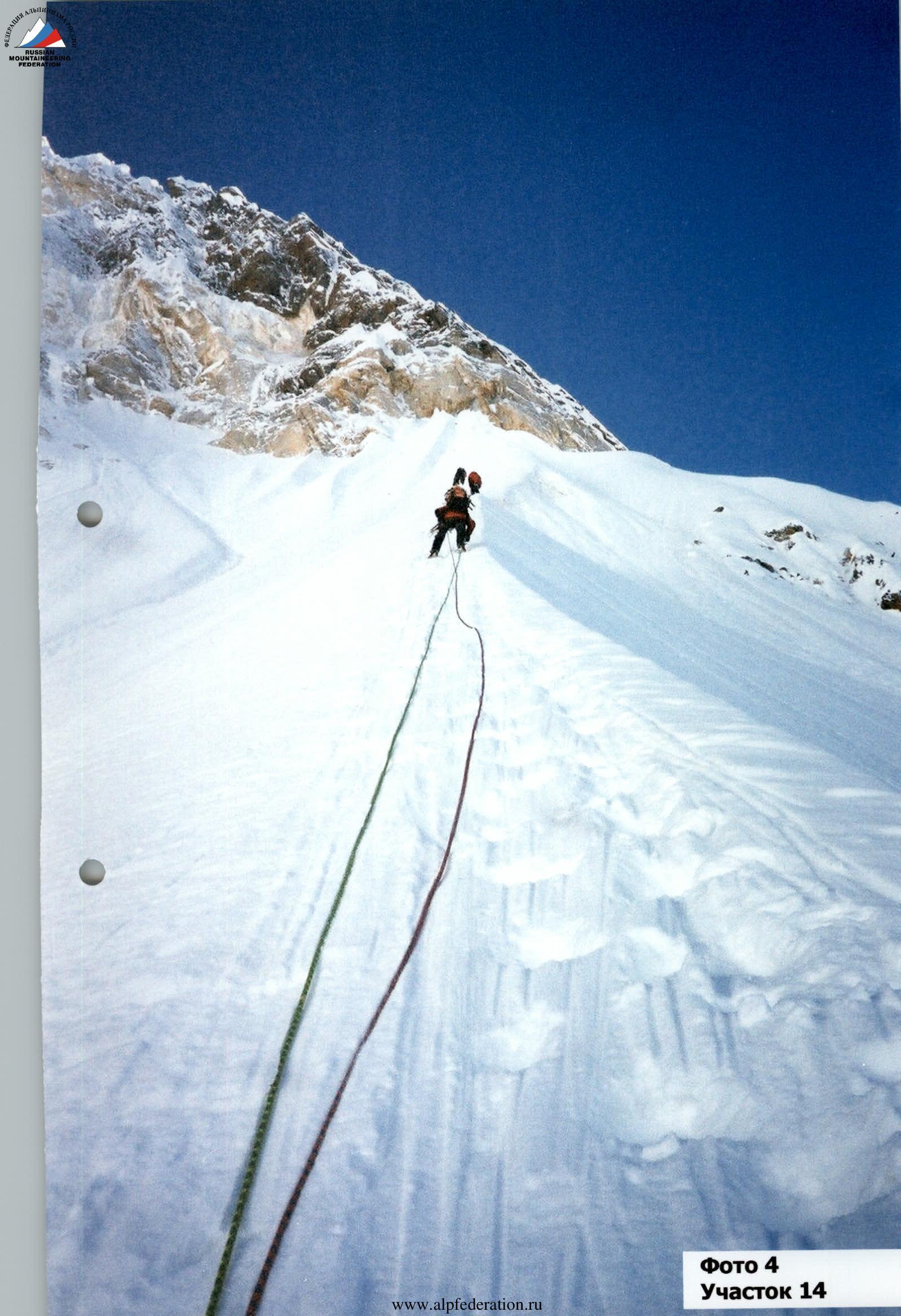
Photo 4. Section 14
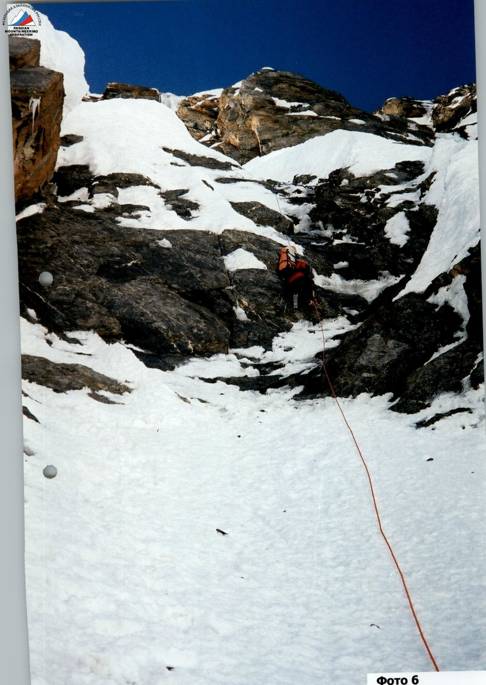
Photo 6. Section 28
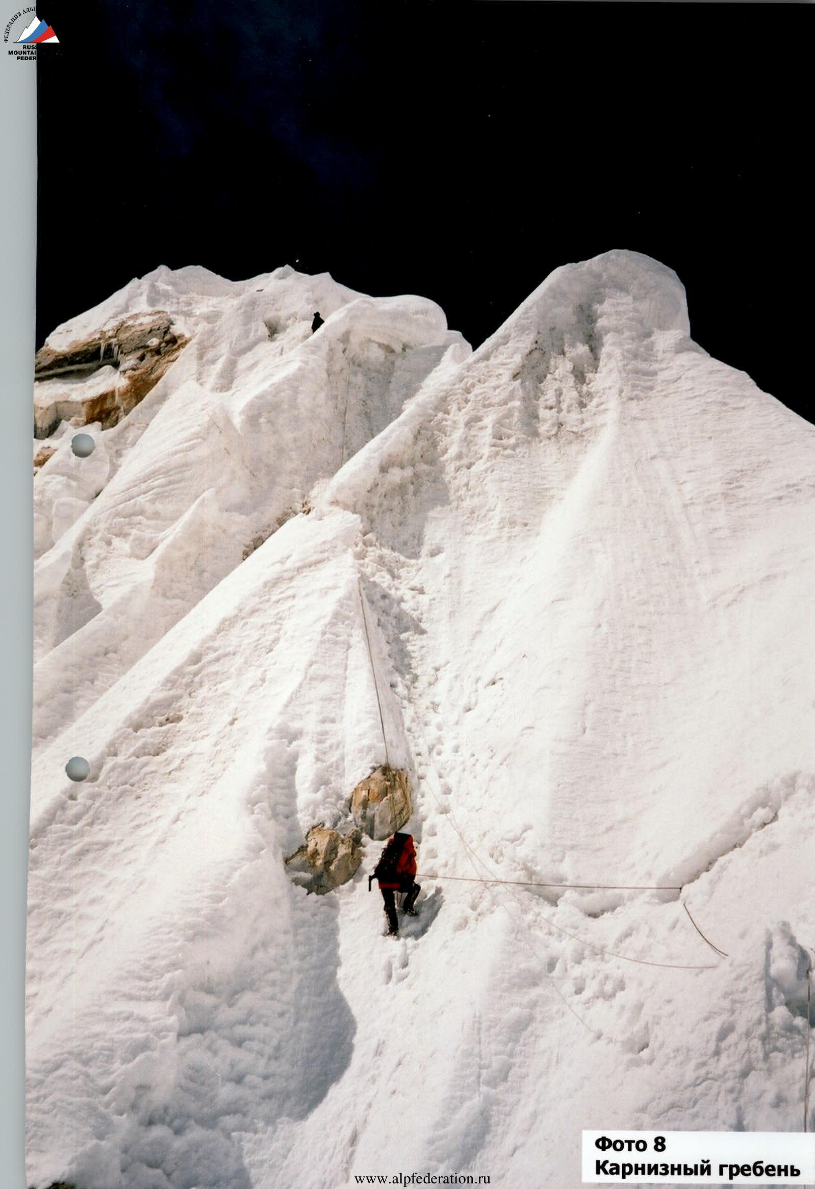
Photo 8. Cornice ridge
Comments
Sign in to leave a comment