Passport
- Altitude class.
- Central Tian-Shan, Tengri-Tag ridge.
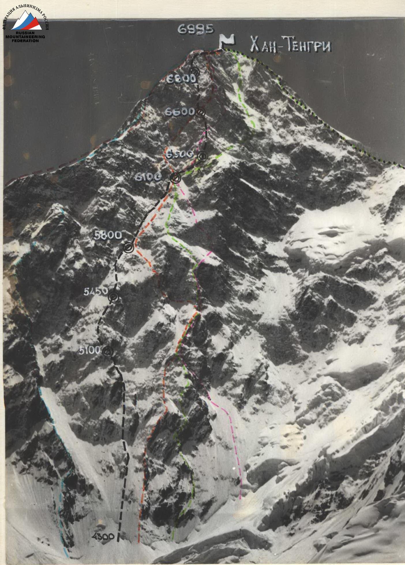
- Khan-Tengri peak (6995 m.) via the left buttress of the center of the North face.
- Proposed 6th category of difficulty first ascent.
- Height difference 2700 m., length 3570 m.
Length of sections with 5-6 category of difficulty: 1400 m. Average steepness of the main part of the route: 58°.
- Number of pitons used:
| Rock | Chocks | Ice |
|---|---|---|
| 284 | 37 | 97 |
| II | 5 |
- Team's climbing hours: 83 and days 8.
- Overnights 1-6 on platforms, 7 - carved into rocks.
- Leader: Gorbeko Mstislav Mstislavovich - Master of Sports
Team members: Sitnik Mikhail Alexandrovich - Master of Sports, Alperin Vladimir Maevich - Master of Sports, Serenkov Pavel Sergeevich - Master of Sports, Bazilevsky Nikolai Mikhailovich - Candidate for Master of Sports, Erohin Oleg Valerievich - Candidate for Master of Sports, Todorov Viktor Stepanovich - Candidate for Master of Sports.
10. Coach: Sviridenko Vadim Sergeevich, Honored Coach of the Ukrainian SSR.
11. Departure to the route: August 10, 1987.
Summit: August 17, 1987.
Return: August 18, 1987.
12. Alpinism club "Odessa" of the Odessa Regional Council of the Trade Unions' Physical Education and Sports Society.
— M-T a/c "Odessa" 1987
M-T Descent
Photo 1
2.08. 14:00 "Industar" 5-4.8 km.
H=4.3 km
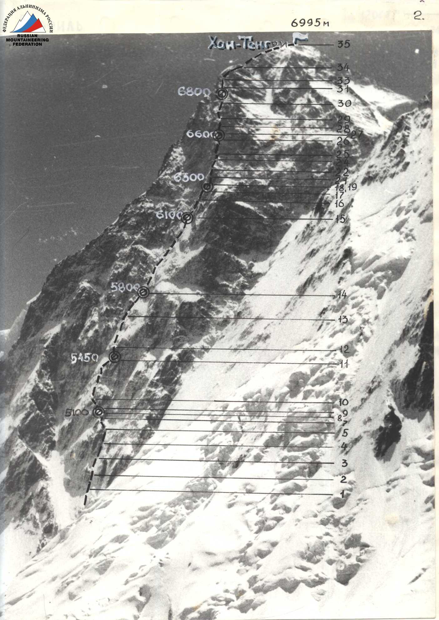
Photo 2. Profile from the right
8.08 13:00 "Industar"
S=6 km
H=4200 m

Photo 3. Profile from the left
6.08 11:00
"Change"
S=1 km H=5700 m
 6995 m August 17, 1987
6800 m August 16, 1987
6600 m August 15, 1987
6300 m August 14, 1987
6100 m August 13, 1987
5800 m August 12, 1987
5450 m August 11, 1987
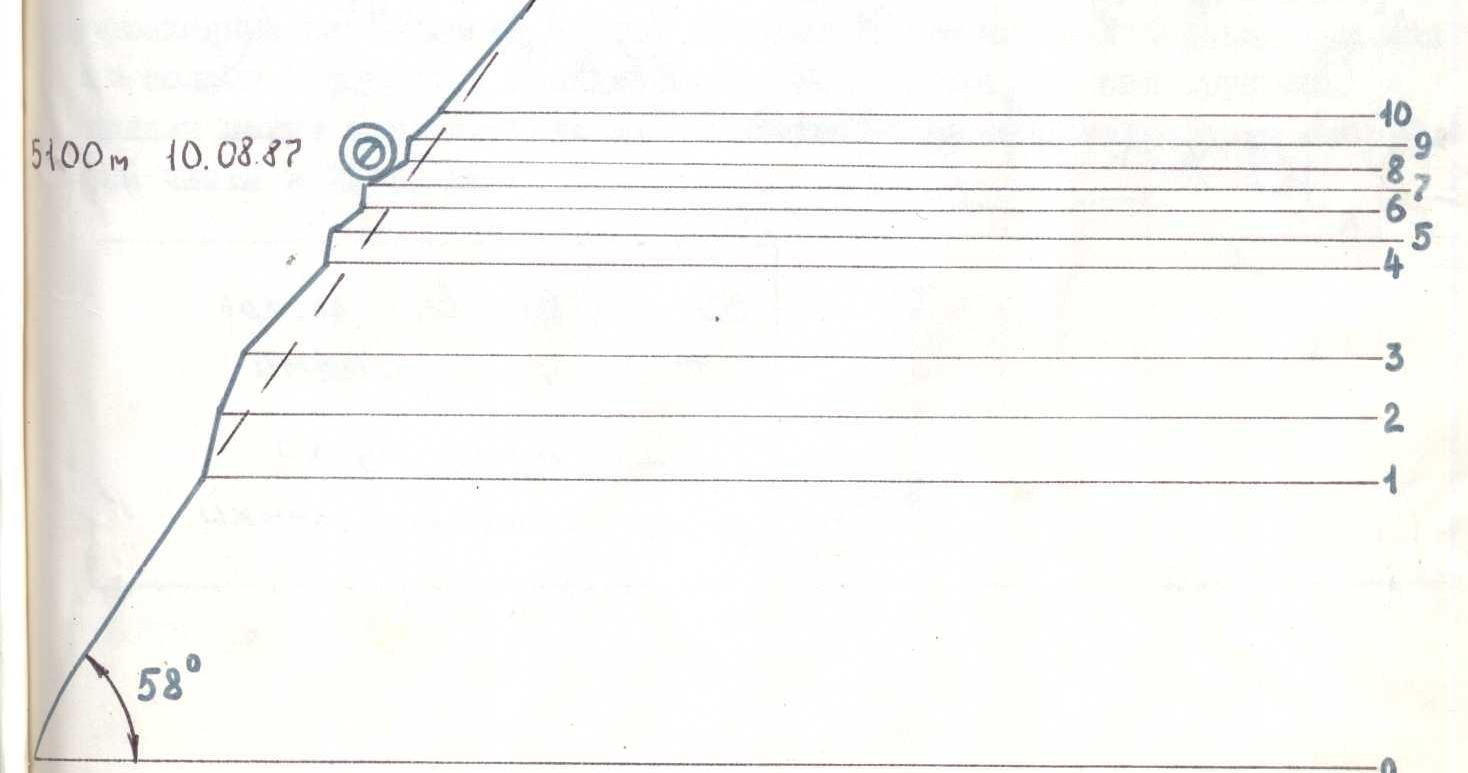
5100 m August 10, 1987
6995 m August 17, 1987
6800 m August 16, 1987
6600 m August 15, 1987
6300 m August 14, 1987
6100 m August 13, 1987
5800 m August 12, 1987
5450 m August 11, 1987
5100 m August 10, 1987
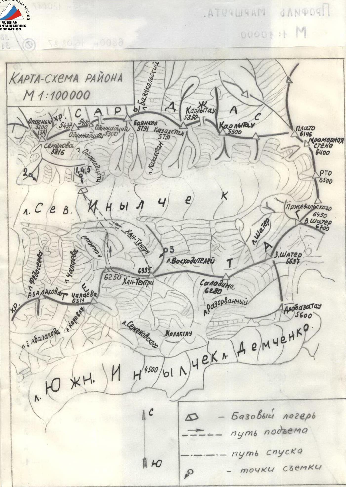
Map-scheme of the area
M 1:100000
— Base camp — ascent route — descent route — shooting points
Brief overview of the climbing area
Khan-Tengri peak (6995 m.) is located in the Central Tian-Shan in the Tengri-Tag ridge.
The exploration of the Khan-Tengri area began with German scientist and traveler G. Merczbacher in 1903, continued by Soviet climbers M.T. Pogrebetsky, V.M. Abalakov and others.
The first ascents from the north were made in 1964 by participants of K.I. Kuzmin and E.I. Tamm's expedition.
Later, routes to the peak were laid from the north:
- Khudyakov (1970)
- E. Myslovsky and B. Studenin (1974)
- Koroteev (1986)
For training and acclimatization ascents, peaks Saladin (6280 m.) and Chapayev's shoulder (6250 m.), located in the Tengri-Tag ridge to the left and right of Khan-Tengri respectively, are most convenient.
On the North Inylchek glacier and lateral moraines, there are several places convenient for setting up a base camp, however, the place on the medial moraine opposite the cirque should be given preference (the shortest approach to the route and convenience of visual observation, proximity of the helicopter landing site on the glacier).
Weather conditions are characterized by instability, abundance of precipitation (snow), strong winds, and fog.
Fresh snow usually disappears to the level of normal snow cover in 1-2 days under the influence of wind and great steepness.
The most rational organization of the base camp is by helicopter along the route Przewalski - border outpost - North Inylchek glacier. Foot options are not excluded, such as from the Bayankol valley through the Eleven Pass or from the Merczbacher meadow, bypassing Merczbacher Lake, but they are labor-intensive and hardly can be accepted for an expedition with a sports part duration of 25-30 days.
Preparation for the ascent
Physical and technical preparation of candidates for the team, in addition to training and assessments in the city, included the following main training camps:
- March 1-16 in the Caucasus, with multiple ascents to the summit of Elbrus from 3800 m.
- May 1-15 in Crimea, ascents on rock routes of V-VI category of difficulty.
- June 20 - July 20 - Pamir, Asan-Ugan area (ascents of V-VI category of difficulty, Lenin Peak).
By the start of the championship, the team had sufficient fitness and preliminary acclimatization.
During the wait for the helicopter from July 25-29 in Mayadyr, physical fitness standards were met, and training ascents were made to peaks of 4200 m.
During the immediate preparation of the team for the ascent, to select the team composition, study the specifics of the wall relief, prepare equipment, practice snow techniques, and achieve altitude acclimatization, the team made ascents to Saladin Peak (6280 m) of 5th category of difficulty in two groups of 6 people.
The ascent was performed by two groups of 6 people.
The study of the wall was conducted using observation equipment (50x telescope, MTO-1000 lens, 8x binoculars) from the base camp and other observation points both from the North Inylchek glacier and from the slopes of Saladin Peak, Chapayev Peak, and Semenov Glacier.
With sufficient information from Myslovsky, Studenin, Koroteev's reports, consultations with Petraško, Studenin, Staroseltsev, Elagin, the team planned a route via the left buttress of the center of the North face, which is a first ascent and contains a number of challenges not overcome by previous teams.
Problematic sections and ways to overcome them:
- height gain from the bergschrund at 4300 m to the bivouac on the buttress at 5100 m, early departure, and passage of the ice wall before it is illuminated by the sun (13:00).
- rock walls at 5450 m, 6400-6900 m to be climbed on a double rope, mainly during processing.
Radio communication within the team and with the base camp was maintained using two "Bosh" radios. The rescue team, consisting of 8 people, had the right to ascend Khan-Tengri via a 5-6 category of difficulty route.
At the time of the team's departure to the summit, the rescue team was supposed to be at around 6000 m on the western ridge of Khan-Tengri.
Ascent schedule
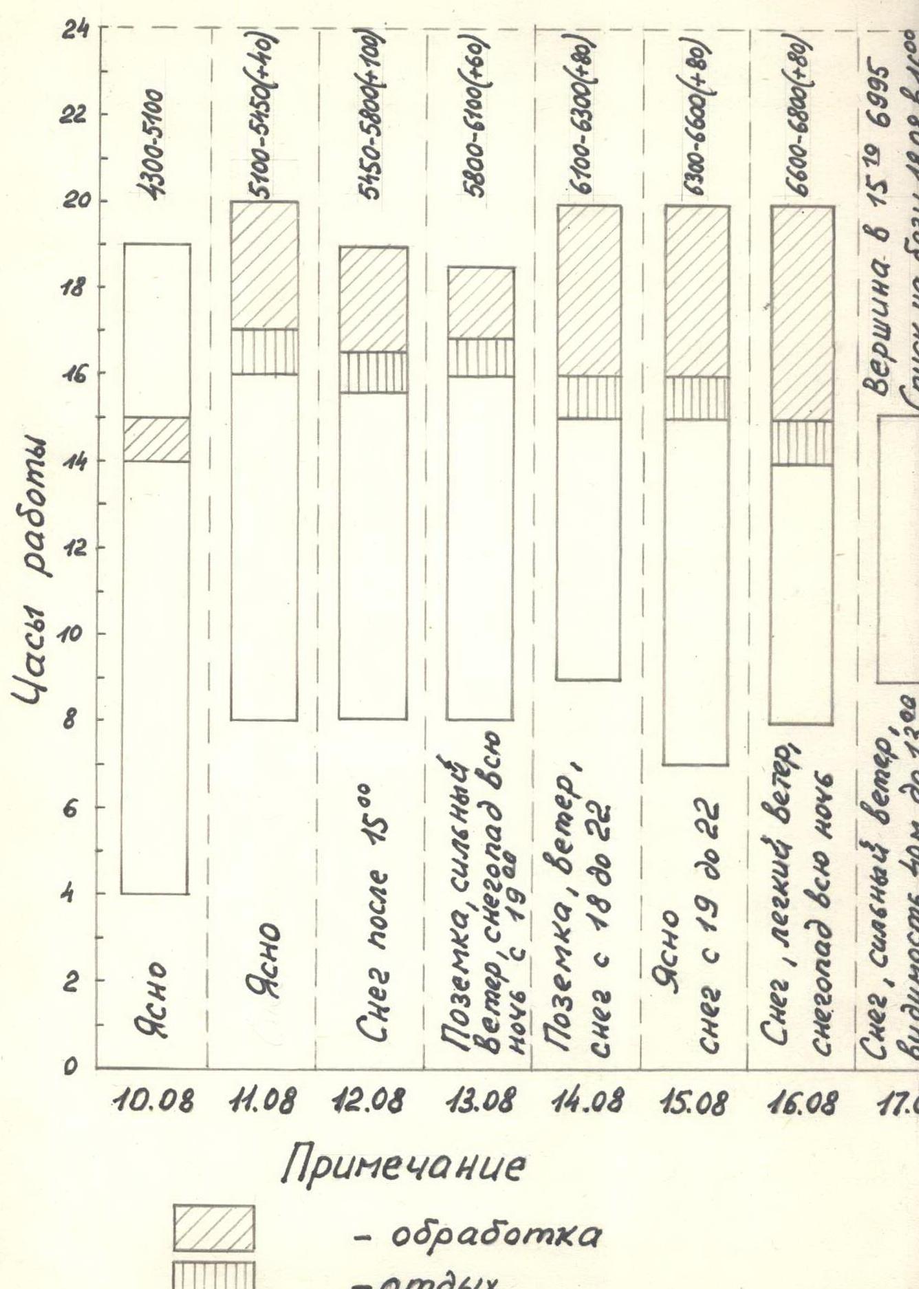
Note:
- — processing
- — rest
- 5100-5450 (+40) — height gain for the day before the bivouac plus height gain after processing
Team's tactical actions
The team followed the planned route in full accordance with the tactical plan and the time schedule.
Minor deviations of 1-2 hours were associated with changes in weather conditions and the transfer of the bivouac site at 6360 m instead of 6400 m for safety reasons.
To ensure safety in conditions of increased complexity throughout the route, fixed ropes were organized.
The planned speed of movement was achieved by daily rotation of leaders (sometimes twice a day) and evening processing of the subsequent section of the route.
Actual rotation of leaders by days and sections of the route:
- 10.08: R0-R2 — M. Gorbeko, R2-R6 — M. Sitnik, R6-R8 — N. Bazilevsky
- 11.08: R8-R11 — N. Bazilevsky, R11-R12 — V. Alperin, R12-R13 — O. Erohin, R13-R14 — V. Todorov, start of R14-R15 — M. Gorbeko (processing)
- 13.08: R14-R15 — P. Serenkov, R15-R16 — M. Gorbeko (processing)
- 14.08: R15-R16 — N. Bazilevsky (processing), R16-R18 — M. Gorbeko, R19-R21 — M. Sitnik (processing)
- 15.08: R21-R27 — N. Bazilevsky, R27-R28 — N. Bazilevsky (processing)
- 16.08: R28-R31 — M. Gorbeko, R31-R33 — M. Sitnik (processing)
- 17.08: R33-R34 — M. Gorbeko, R34-R35 — M. Sitnik, R34-R35 — N. Bazilevsky
Technical means and methods of ensuring safety for the first climber on complex sections were standard: double rope, piton insurance — on ice screws and rock pitons, lengthened by 1.5 times, specifically for the type of rock on Khan-Tengri.
Insurance points were organized on 3 or more pitons (chocks) and were mostly convenient, except for hanging ones on ice and rock walls. (photos 7, 14, 15)
Daily movement regime: 8:00 (7:00) - 14:00 (16:00), processing 16:00 (17:00) - 19:00 (20:00).
Processing time coincided with the setup of the bivouac. On the first day of the ascent, departure to the route at 4:00 and end of work at 19:00 were due to the nature of the ice relief.
Due to the lack of convenient platforms for the entire group to gather throughout the route, and considering the specifics of high-altitude climbing, each participant received a daily ration in a package and used it at their discretion.
For the equipment of a platform on a snow slope with a steepness of 45°-50°, car mats were used to retain the side walls. This technique was used for the first time and fully justified itself. (supplementary photo)
The choice of bivouac sites, the safety of which was assessed visually from the base camp, was largely confirmed, both in terms of protection from avalanches and in terms of the movement schedule.
Bivouac at 6100 m:
- Not recommended for subsequent groups.
- It should be moved 100 m to the right and up.
There were no falls or injuries throughout the ascent. The principle of movement in any weather (snow, wind, blowing snow) was maintained on the route. Processing was not canceled even when stopping at a bivouac in deteriorating weather conditions.
With the observation group, there was mandatory three-time communication, and the base radio station was constantly on receive from 7:00 to 22:00.
Visual observation was continuous. Observation equipment allowed observing each participant and, in some cases, correcting actions in deteriorating weather conditions via radio.
The rescue team (2 groups of 4 people) was located at the base camp.
When the team reached the marble part of the route (above 6000 m), the groups, with a 1-day interval, followed the descent route of the team.

Product table
Individual ration
| Name | Quantity per person per day (g.) | Total per person for the ascent (g.) | Total for the group for the ascent |
|---|---|---|---|
| Chocolate | 20 | 160 | 1120 |
| Caramel "Dusche" | 30 (3 pcs.) | 240 | 1680 |
| Vitamin "C" with ascor | 15 (5 tablets) | 120 | 840 |
| Sweet crackers | 50 | 400 | 2800 |
| Rye crackers | 50 | 400 | 2800 |
| Cookies "Mix 12" | 30 | 240 | 1680 |
| Dried apricot | 40 | 320 | 2240 |
| Raisins | 25 | 200 | 1400 |
| Walnut | 20 | 160 | 1120 |
| Sausage | 25 | 200 | 1400 |
| Bacon | 20 | 160 | 1120 |
| "Russian" cheese | 25 | 200 | 1400 |
| Total: | 350 | 2800 | 19600 |
General nutrition
| Name | Quantity per day (g.) | Total for the ascent |
|---|---|---|
| Beef broth | 90 (1 packet) | 630 (7 packets) |
| "Kokoshka" soup | 90 (1 packet) | 630 (7 packets) |
| Mixture: 1. Oat flakes "Hercules" | per cooking | |
| 2. Dry vitaminized milk | 225 g. | 450 |
| 3. Sugar, salt | ||
| Mixture: 1. Buckwheat groats | per cooking | |
| 2. Dry vitaminized milk | 225 g. | 450 |
| 3. Sugar, salt | ||
| Mixture: 1. Rice | per cooking | |
| 2. Dry vitaminized milk | 225 g. | 450 |
| 3. Sugar, salt | ||
| Sugar | 312.5 | 2500 |
| Tea | 37.5 | 300 |
| Total: | 5410 |
Total products: 25010 grams.
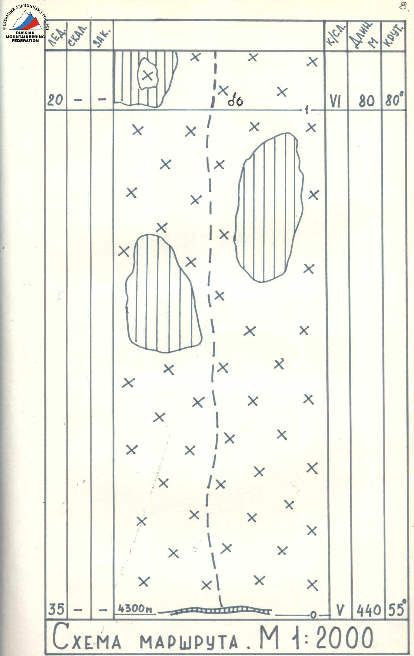
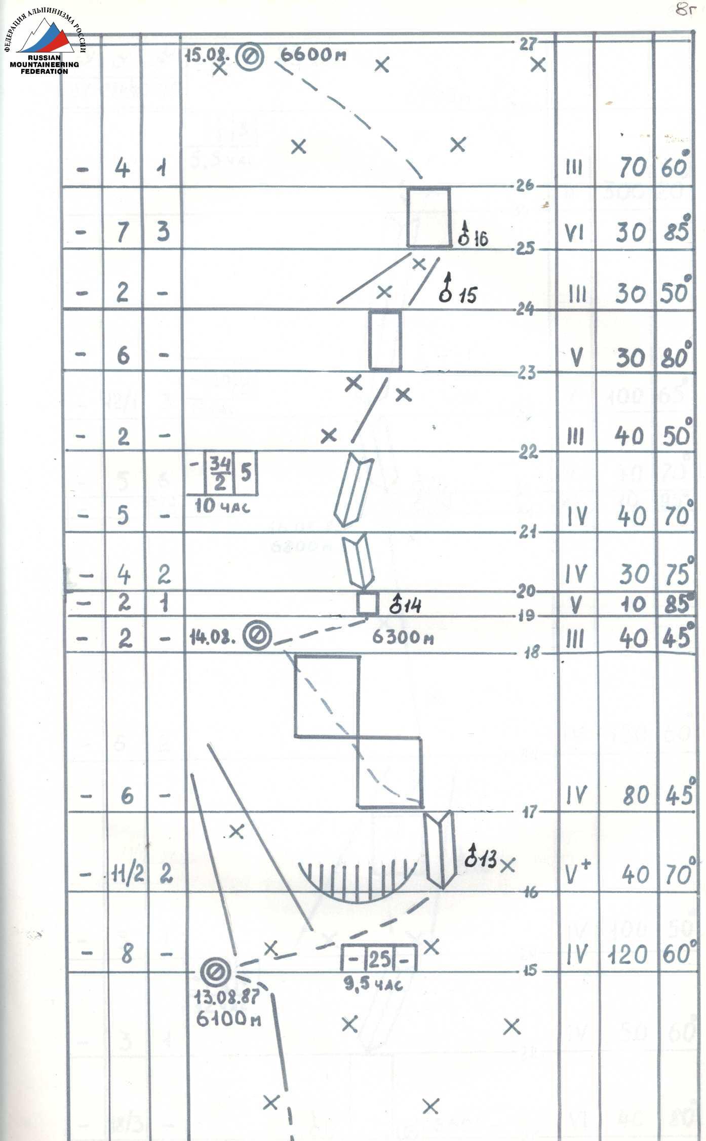
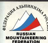
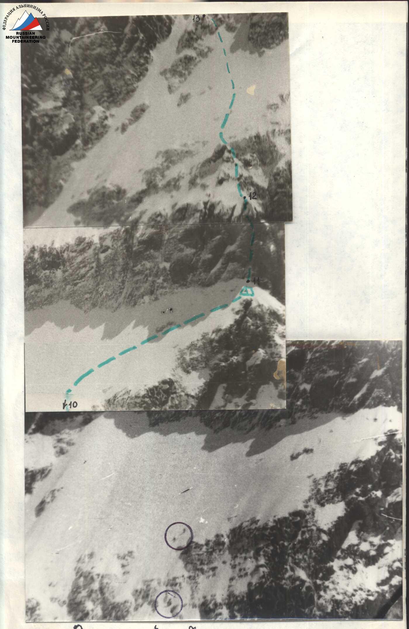
Route scheme
M 1:2000
Description of the route by sections
Approach to the start of the route from the northern cirque of Khan-Tengri peak along a snow slope with a steepness of up to 45° in the direction of the left buttress of the center of the North face for 350-400 m. Avalanche hazard. Possible ice fall from the left shoulder of the peak. Departure early in the morning. Steps in the snow are formed well. The start of the route is from the bergschrund, which is traversed via a bridge.
R0-R1. The section is avalanche-prone, so it is traversed early in the morning, at a fast pace, under the cover of rocks. To speed up, fixed ropes are organized. The ice is porous, for insurance, lengthened ice screws are used. R1-R2. The first and second ice steps. Steepness increases sharply. Sections are traversed using "ice axes," under the cover of the left rocks. R2-R3. The couloir between the rocks of the buttress and the main wall is prone to rockfall, it is necessary to pass before the top of the wall is illuminated by the sun (13:00). At the end of the section, under the cover of rocks — rest, food, and tea. R3-R4. Exit from the couloir to the ridge of the buttress — via a steep and very destroyed shale wall. Movement along a ledge to the left for 6-7 m, then up. On the ridge, the reliability of the insurance point is ensured with the help of ice screws hammered into the destroyed rocks — "carrots." The first climber goes without a backpack. R4-R5. The ridge is snow-covered, under the snow — ice. Platforms for tents are formed from snow using car mats. Preparing the bivouac takes about 2 hours. Movement along the ridge — in crampons. R5-R6. Rock steps on the ridge are overcome with careful insurance using two ropes. The first climber goes without a backpack. R6-R7. The buttress changes its general direction to the right and up. Movement along loose snow, heavily snow-covered and icy rocks. Insurance is piton-based on rock outcrops. The section is not dangerous for avalanches and rockfall, as their paths are to the right, but along steeper slopes. Overnight stay — on a slope under the cover of a steep rock barrier on a platform built by the group. R7-R8. The rock barrier is overcome in the least high place. Steep destroyed shales require particularly careful movement and careful insurance with lengthened pitons and ice "carrots." The section is processed in the second half of the day when it is illuminated by the sun. Due to increased rockfall danger, movement is along fixed ropes with top insurance. R8-R11. Movement continues upwards with a slight deviation to the left and then along the wall along loose "difficult" snow, icy and snow-covered rocks. The second rock belt is passed in the left part, where it is significantly lower. Further movement goes under the cover of steep rocks on the left. Rocks are shale, but less destroyed than in the lower part of the route. At a height of about 6000 m, along a difficult snow-covered wall — exit to an unexpressed snow ridge, avalanche-prone on the left and right! Overnights, as before, are built on snow slopes using car mats. The overnight stay at 6100 m was organized under the cover of a rock wall, in a place where groups B. Studenin and V. Koroteev had previously stayed. Here all routes intersect. On the afternoon of August 13, 1987, and at night, it snowed, avalanches descended along the couloir to the right of the overnight stay, partly touching the tent. It is better to organize the overnight stay 100 m to the right under a powerful rock wall. R11-R14. Exit to the boundary of rocks made of marble and shale. Due to the bad weather continuing throughout the night, movement started somewhat later than usual. The safest path was viewed from the base camp, and further observation confirmed the correctness of the chosen path. Quickly cross a steep snow couloir (avalanche-prone!) and traverse under the rocks to the right. Here, along a very complex (destroyed, icy rocks) steep inner corner and along snow-covered slabs — exit under the marble wall. R15-R18. The weather worsens again, and the group decides to spend the night here, not reaching the planned location by about 100 m in height. While building another platform using car mats, a complex section of very snow-covered steep rocks is processed, and the "acquaintance" with the marble continues. Chocks are increasingly used for insurance; the rocks are stronger and more reliable than the shale ones. R18-R19. Along a snow ridge — exit to the "first marble triangle." Overnight stay is possible here. R19-R20. Very complex rock walls. Usually, in such cases, a double rope is used for insurance, and the first climber goes without a backpack. Fixed ropes. Sometimes difficulties arise with organizing reliable insurance points (nowhere to hammer a piton). R20-R22. Processed after stopping for the night at the top of the "second marble triangle." R22-R24. Along a snow couloir (move under the cover of the left side) with a wall in the upper part — ascent to a snow-covered ridge, along which the approach is made under an overhanging wall (R31-R32). Overnight stay 20 m from the wall under a large stone, the platform is carved into the marble. R25-R26. The overhanging wall is overcome along a crack using ITO (chocks, ladders). Filled rock relief. R26-R28. Along internal corners, the steepness gradually decreases, but steep walls are encountered. Rocks are heavily icy. On ledges, loose snow. Exit to the dome along deep (1-1.5 m) snow. R28-R29. Along not very steep but "heavy" loose snow, ascent to the summit.
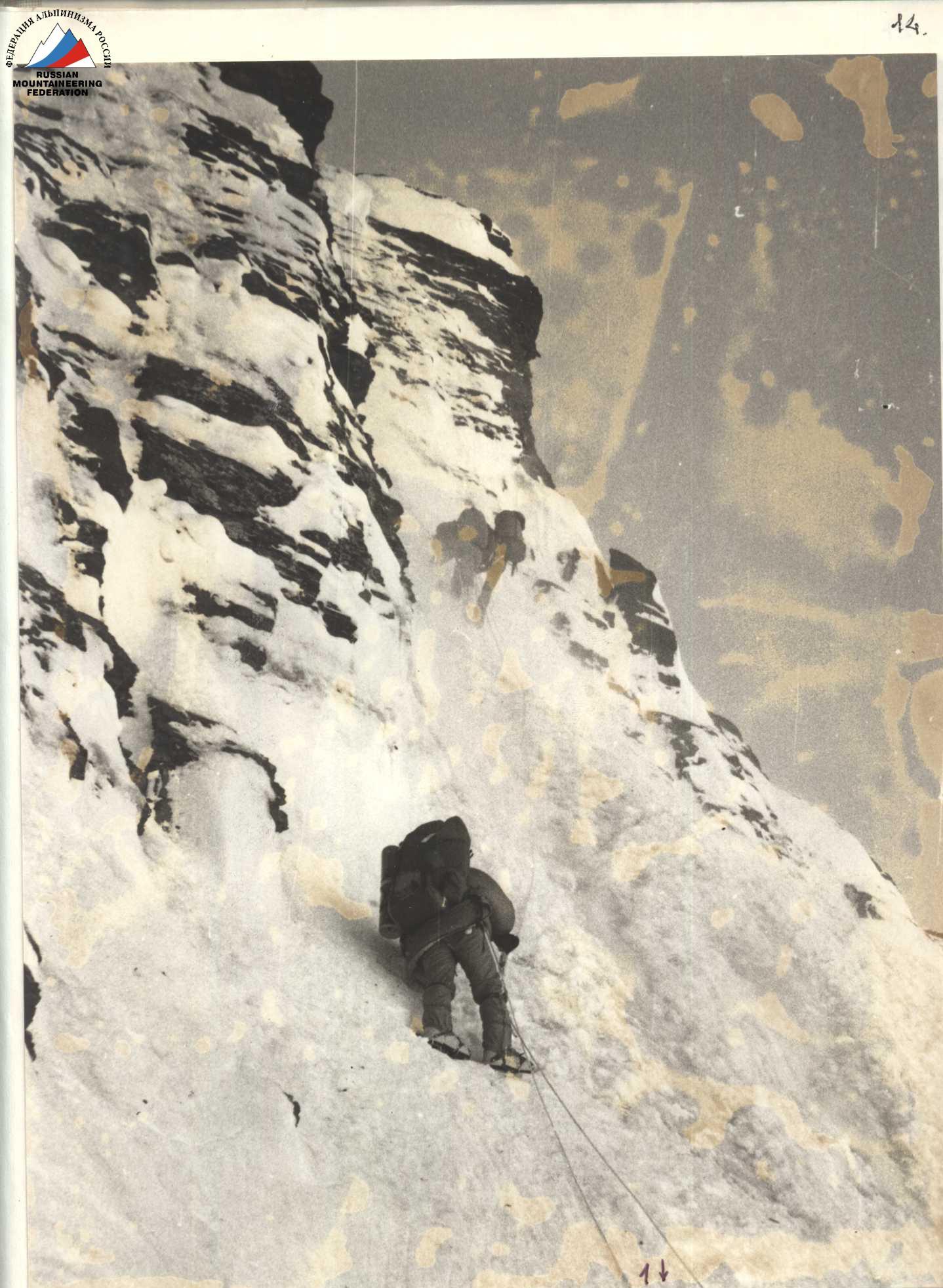
Photo 6. Section R1-R2. The ice slope gains steepness. August 10, 10:00
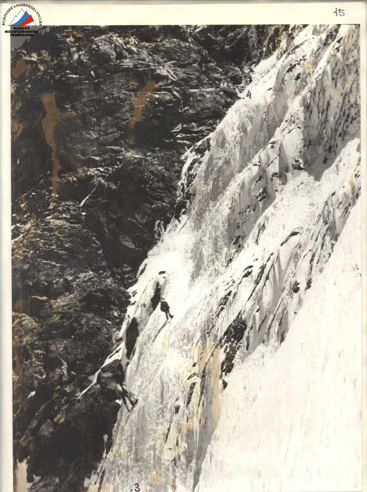
Photo 7. Section R3-R4. August 10, 13:00
Photo 8. Section R4-R5. Difficult exit to the snow ridge. August 10, 17:00
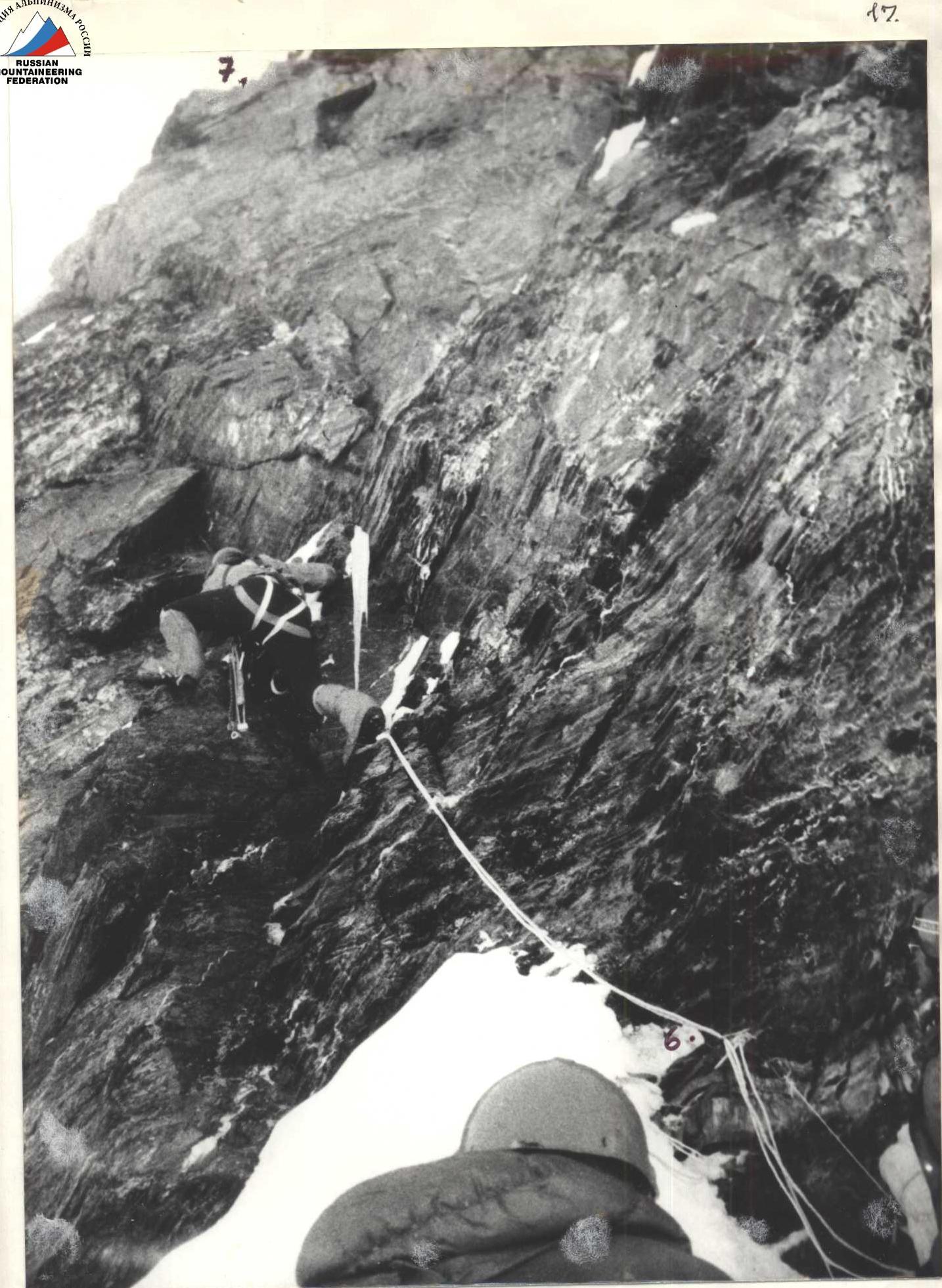
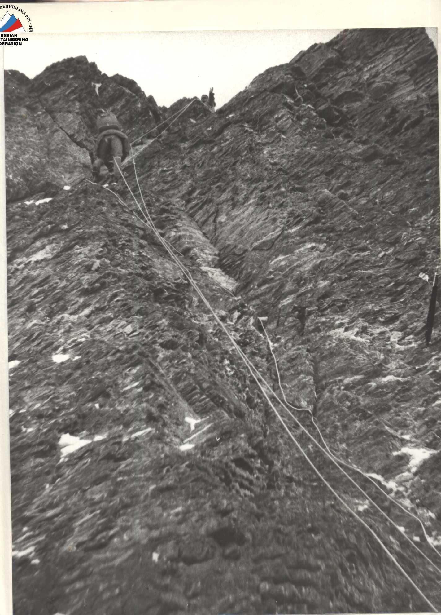
Photo 9. Section R6-R7. Change before the first bivouac. August 10, 17:30
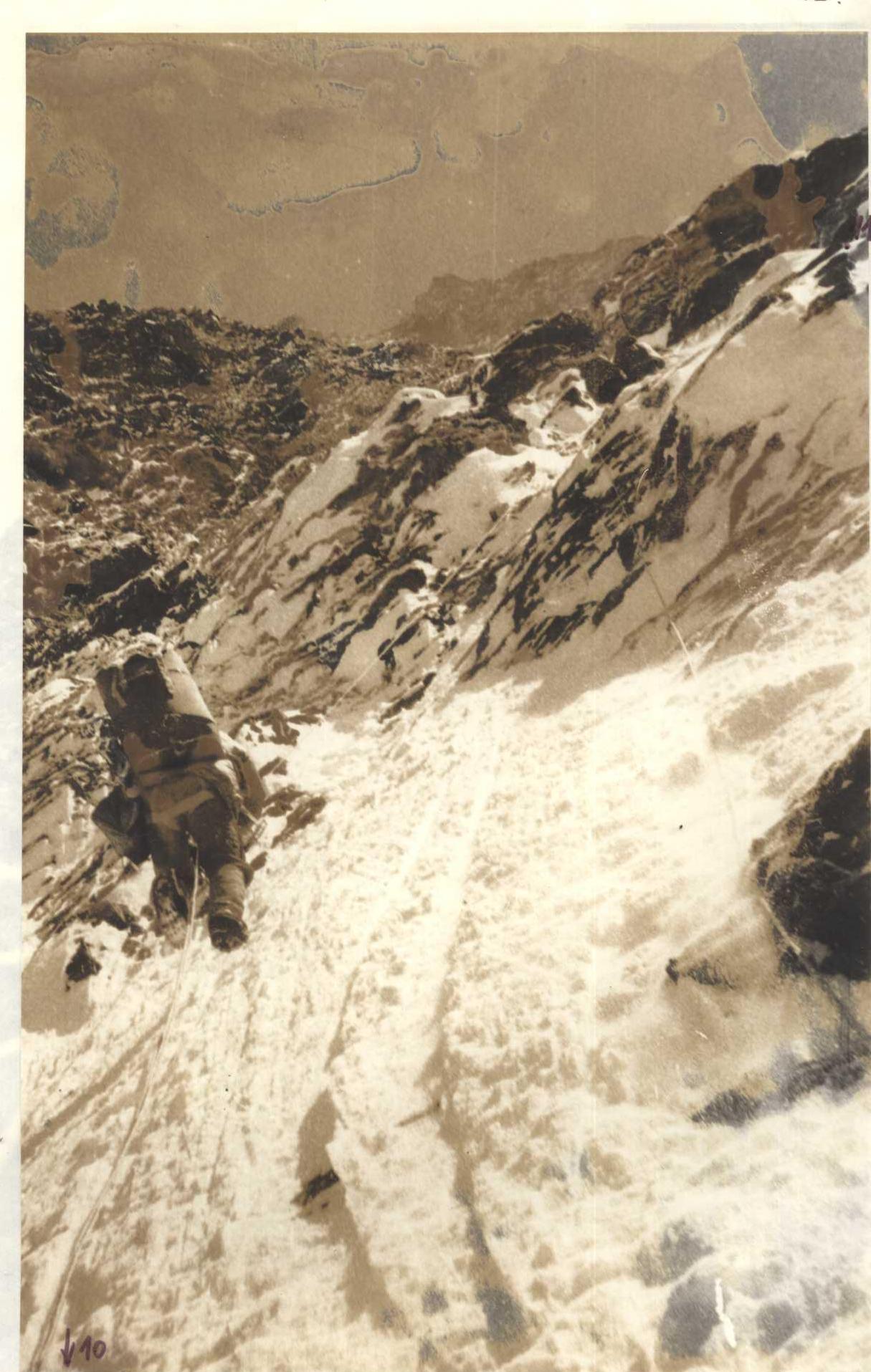
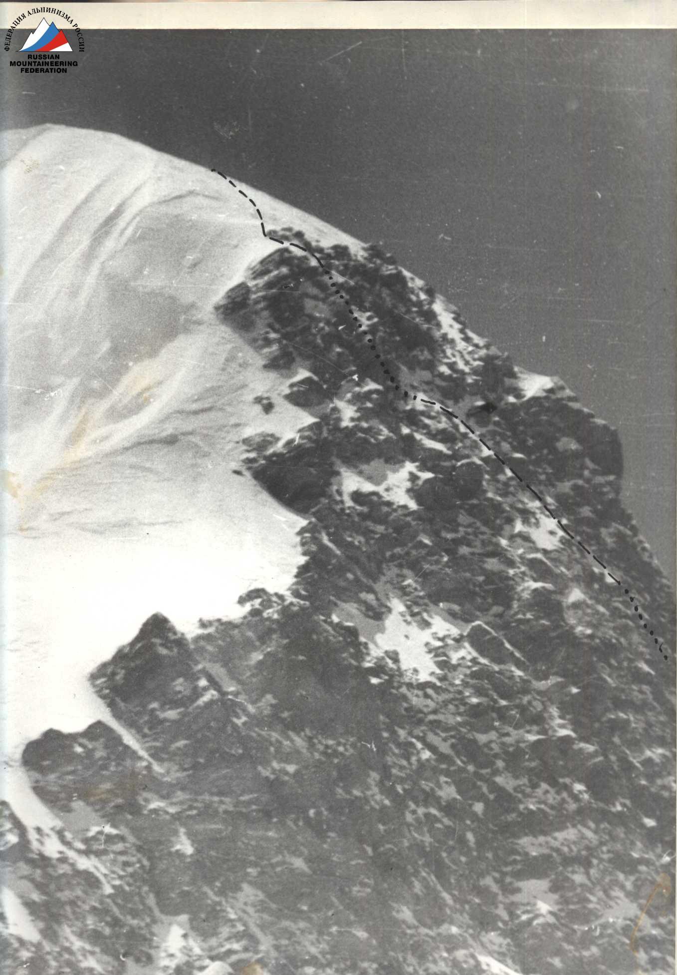
Photo 10. Section R10-R11. On rock outcrops. August 11, 12:00
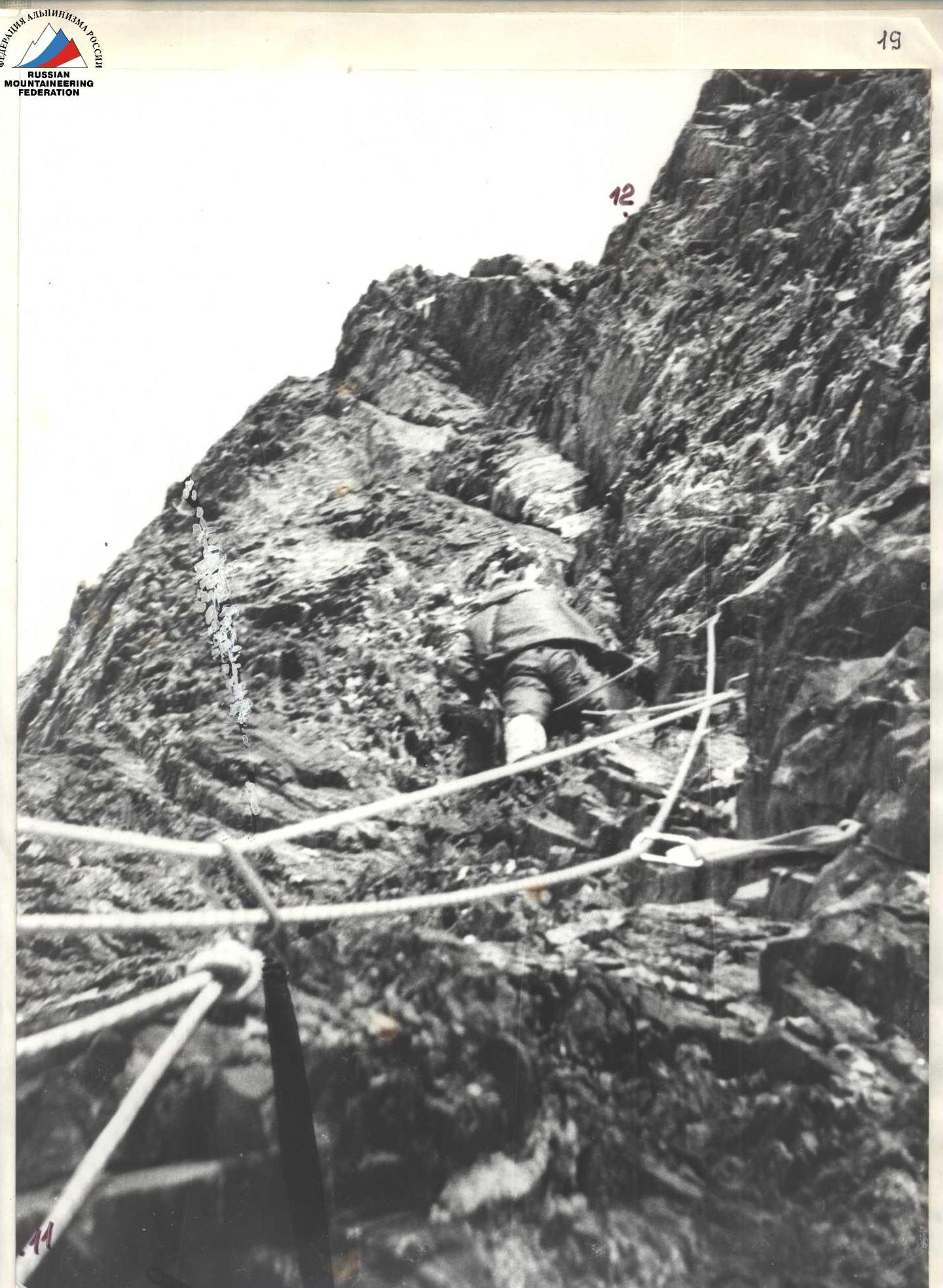
Photo 11. Section R11-R12. Processing the rock barrier. August 11, 17:30
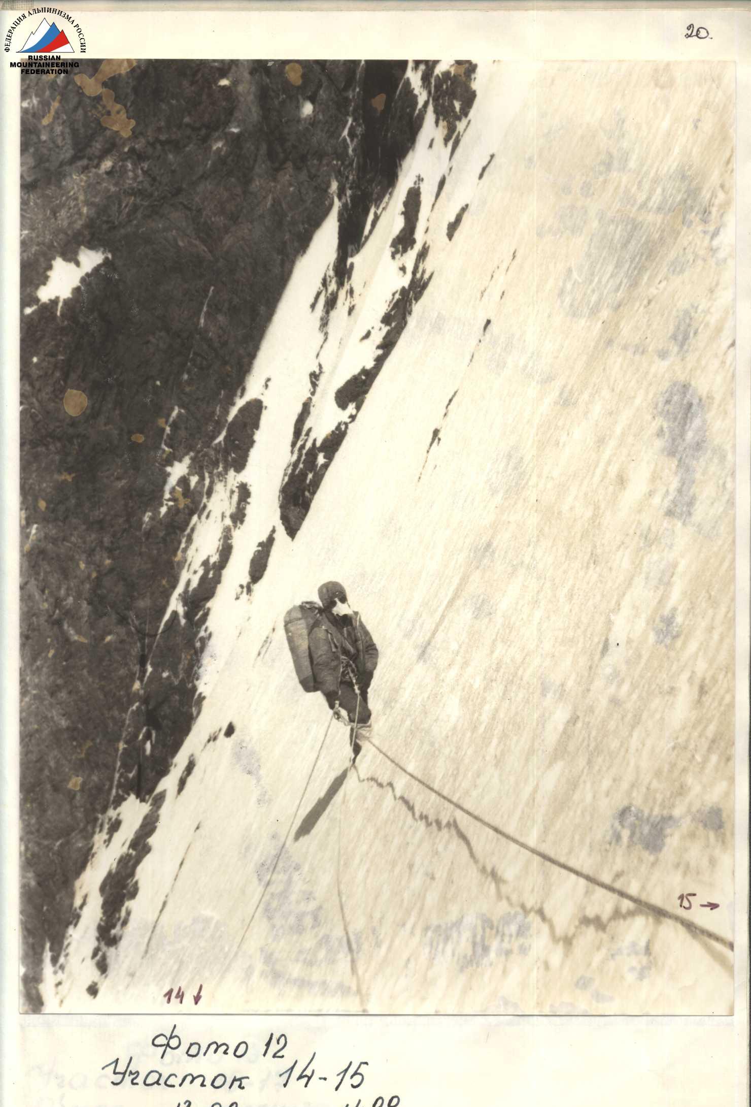
Photo 12. Section R14-R15. August 13, 14:00
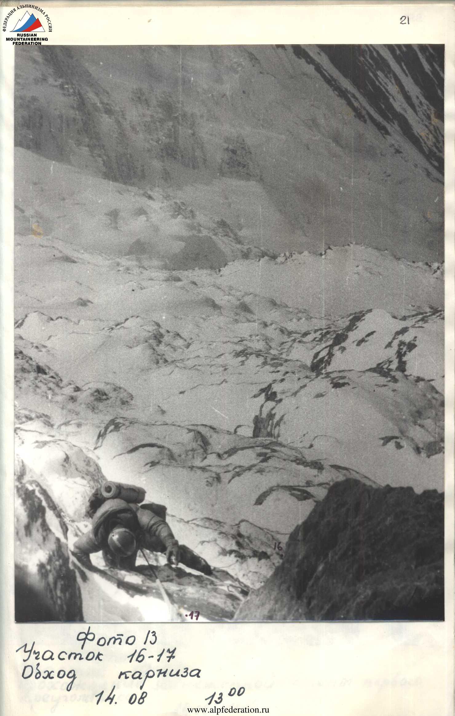
Photo 13. Section R16-R17. Bypassing a cornice. August 14, 13:00
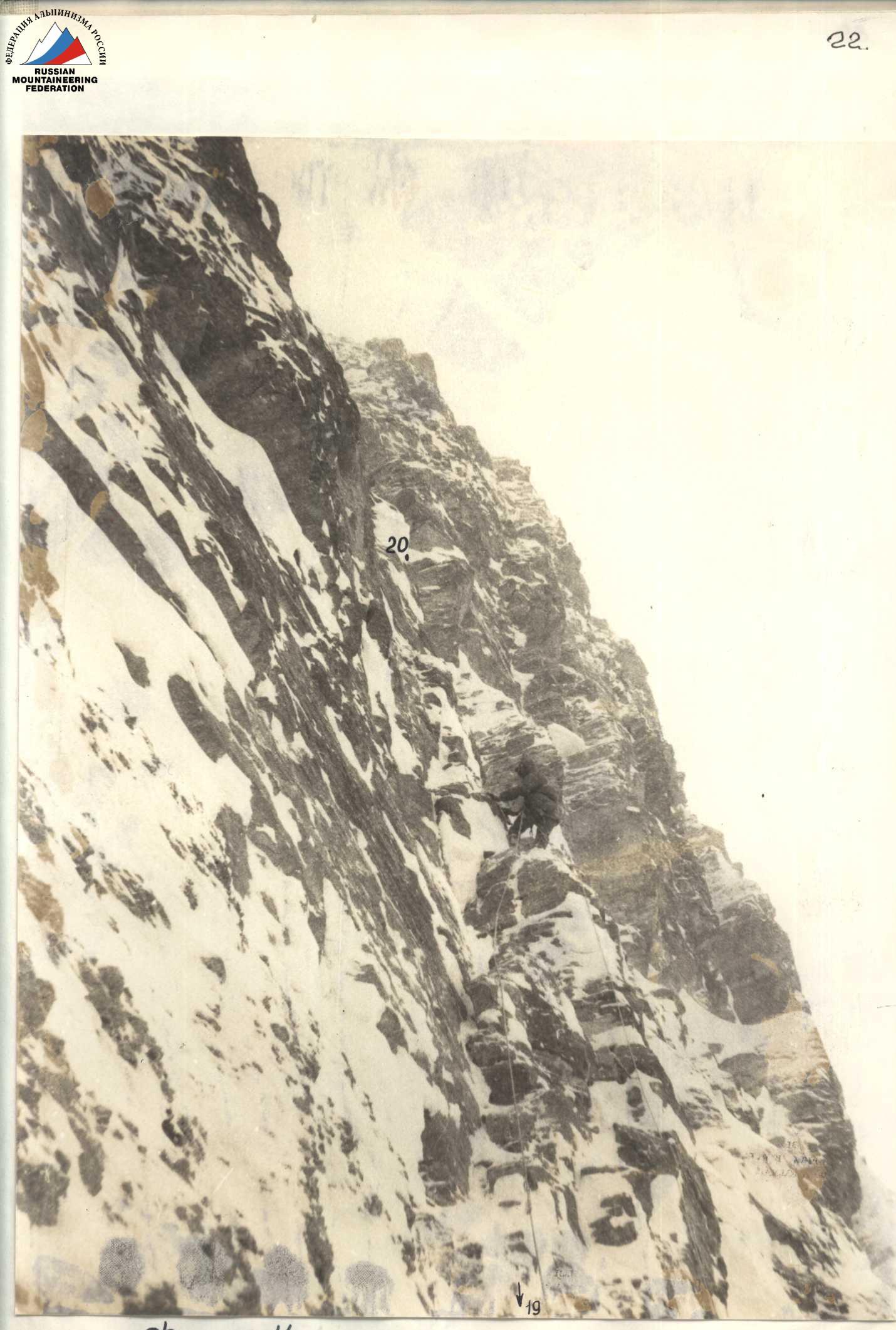
Photo 14. Section R19-R20. Passing a snow-covered wall of the first triangle.
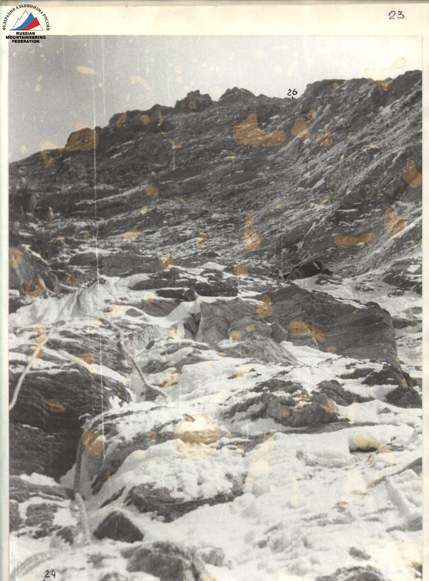
Photo 15. Section R24-R26. August 15, 12:30
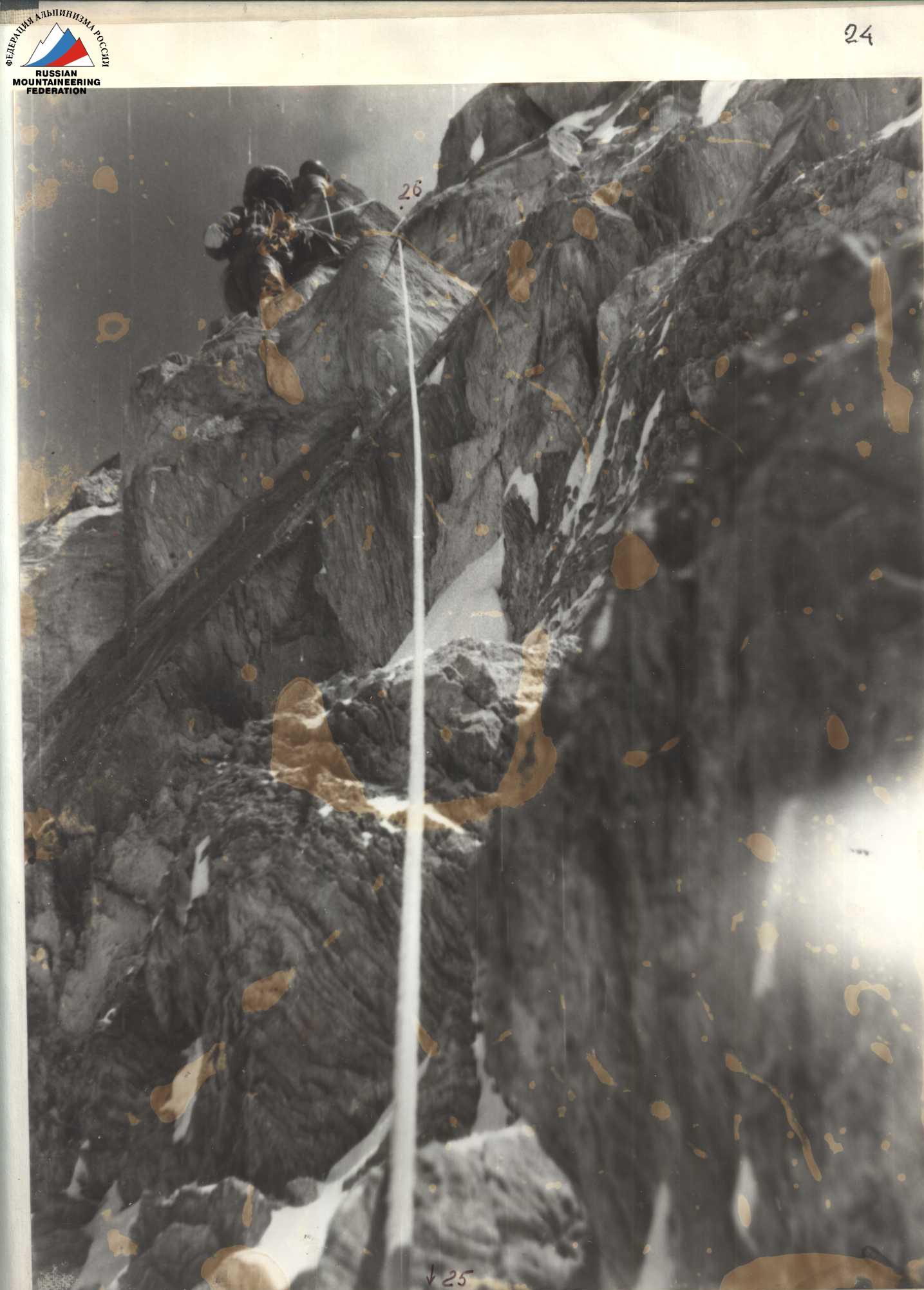
Photo 16. Section R25-R26. Passing a marble wall. August 15, 15:00
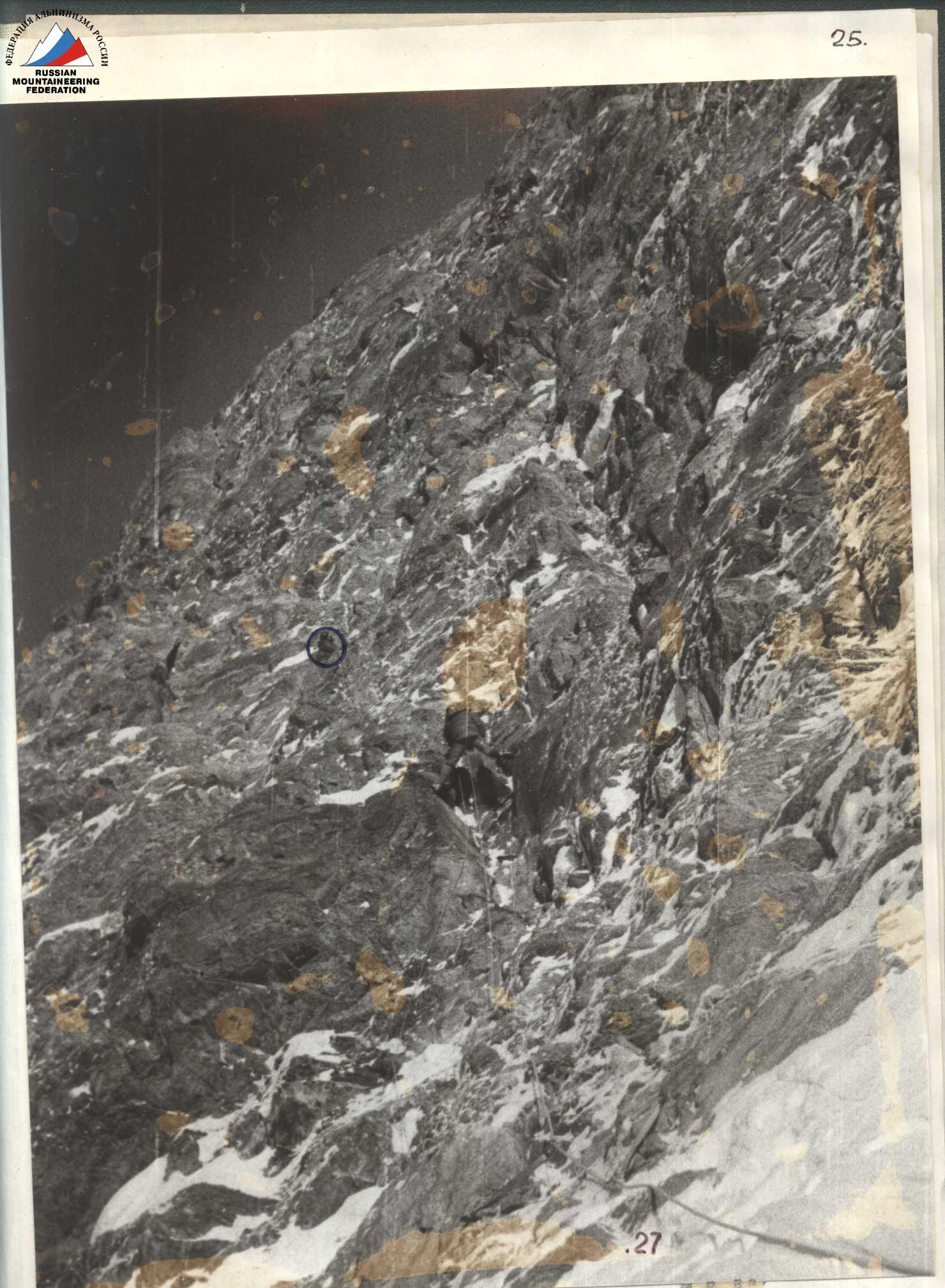
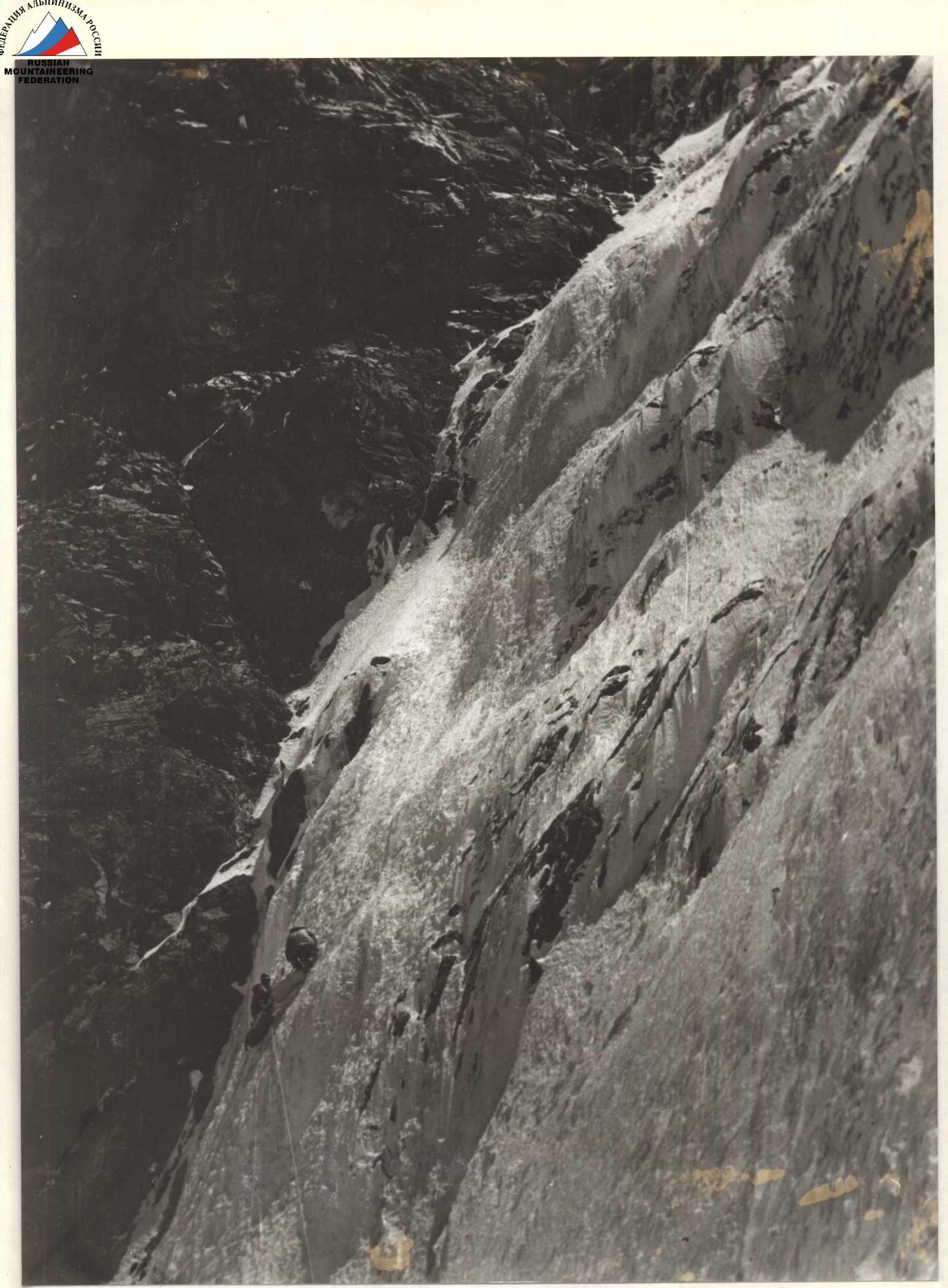
Photo 17. Section R27-R28. Passing a wall along fixed ropes. August 16, 10:00
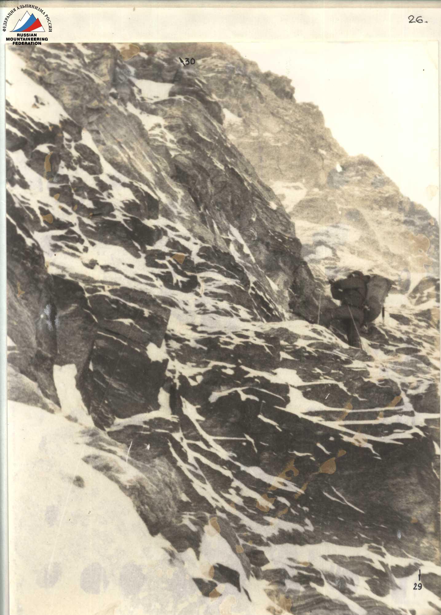
Photo 18. Section R29-R30. In the background, Studenin, Koroteev. August 16, 11:00
USSR Climbing Championship
Altitude class

Addendum to the report on the first ascent to Khan-Tengri peak via the left buttress of the center of the North face by the team of the "Odessa" alpinism club.
View of Khan-Tengri from a helicopter
Photo from 1986.
Passage of the ice wall
On section R3-R4
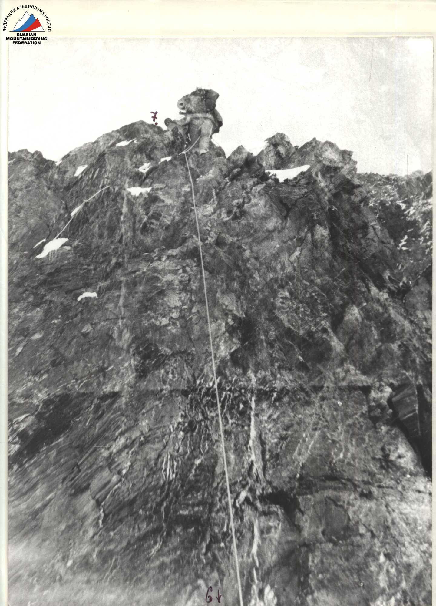
Photo. Passage of the wall along fixed ropes before the first bivouac.
Passage of the rock barrier
Section R11-R12
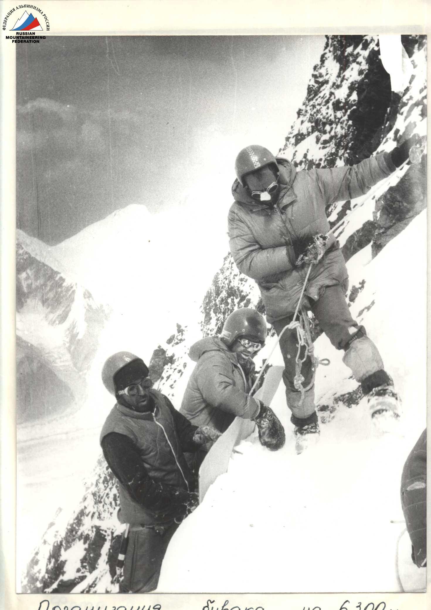
Organization of a bivouac at 6300 m
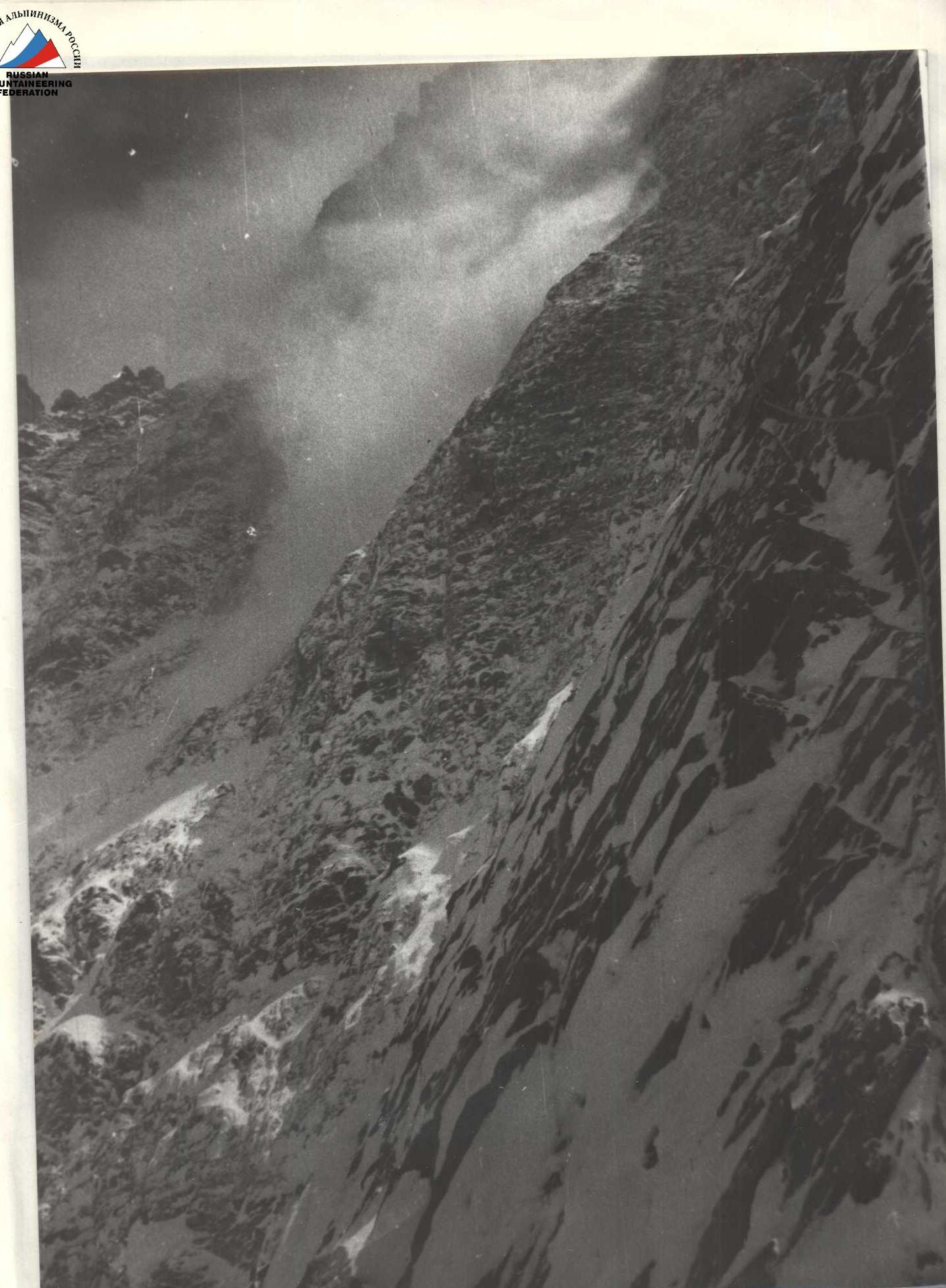
Photo from the 6300 bivouac. Avalanche from the NE buttress.
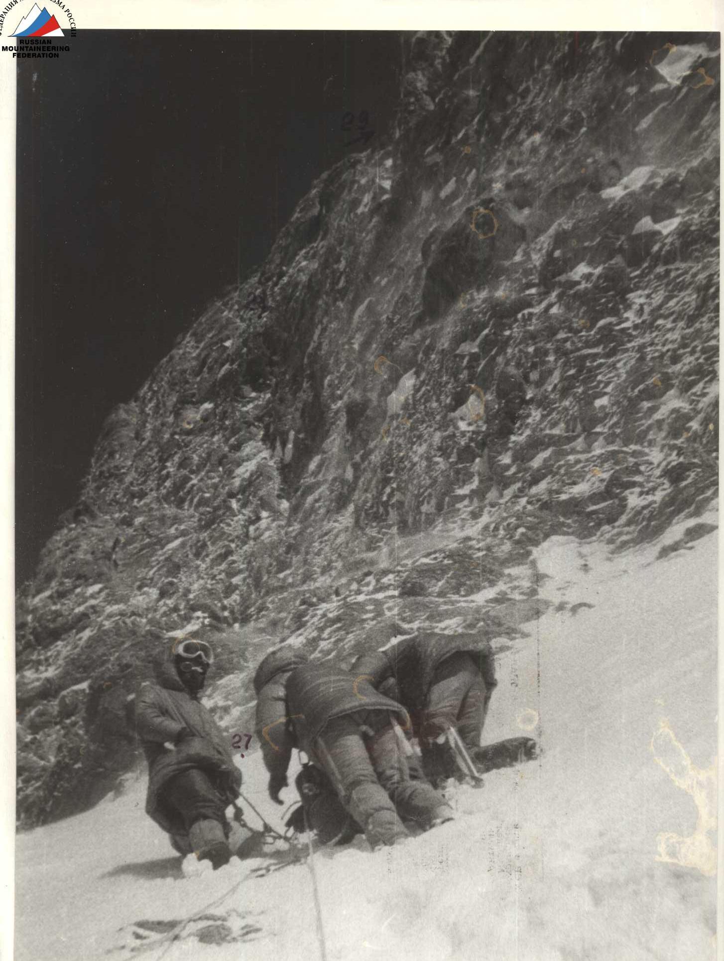
Photo. Section R27-R28. Bivouac 6600. August 15, 15:00
On the dome of Khan-Tengri
August 17, 14:00
Dome of Khan-Tengri
MTO-1000 lens. Shot from the South Inylchek glacier.
Bivouac at 6800 m
Rock barrier, MTO-1000 lens
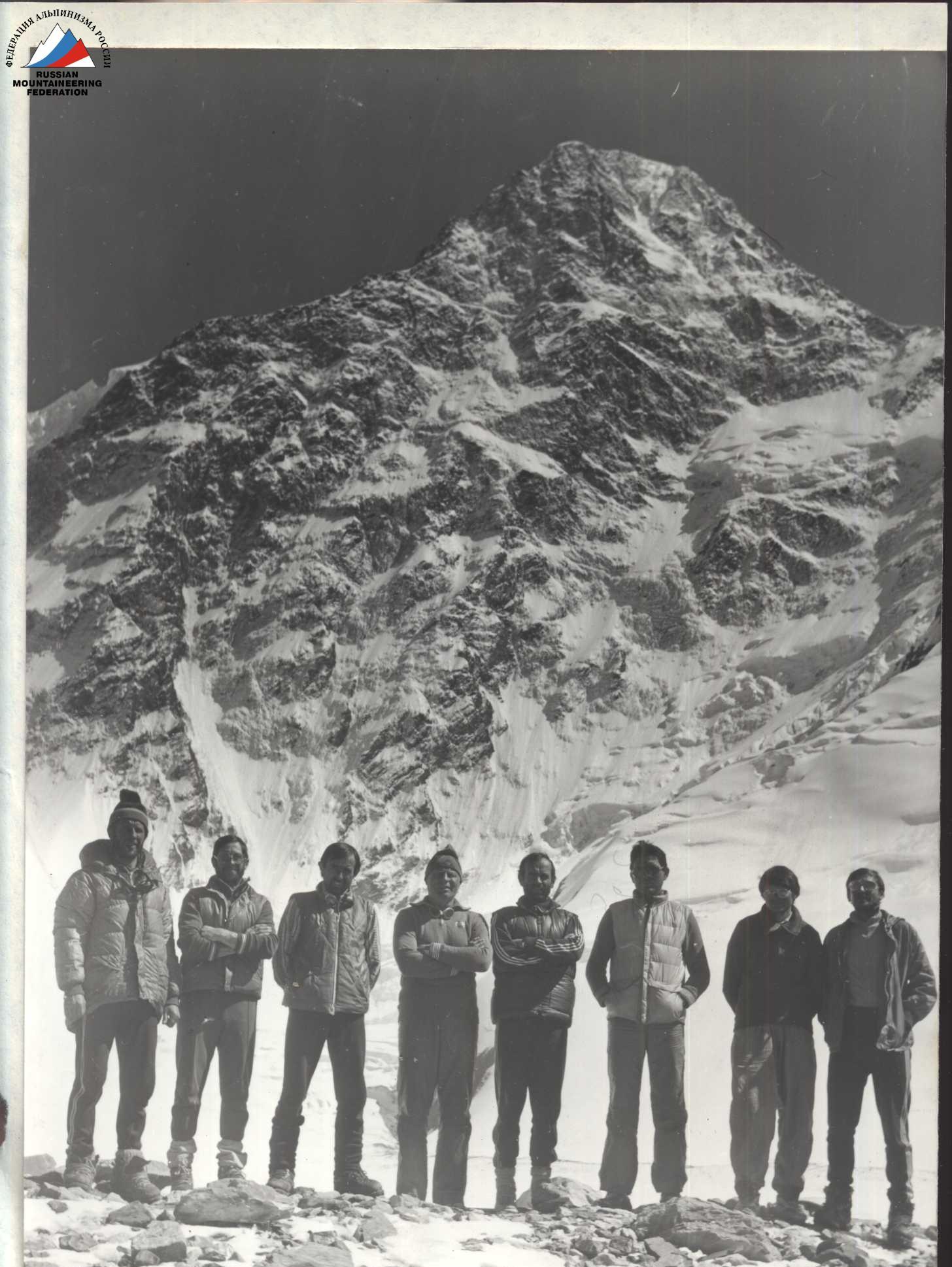
Team after the ascent. From left to right: P. Serenkov, V. Alperin, M. Sitnik, V. Sviridenko, M. Gorbeko, V. Todorov, O. Erohin, N. Bazilevsky.