Ascent Passport
-
Ascent class — high-altitude
-
Ascent area: Tsentralny Tian-Shan, South Inylchek glacier
-
Peak, route: Khan-Tengri peak, 6995 m, via Southeast wall
-
Estimated category of difficulty — 6B, 2nd first ascent
-
Height difference: 2500 m
- total route length — 3140 m
- wall section length — 2500 m
of which
-
5th category of difficulty — 2100 m
-
6th category of difficulty — 400 m
-
average steepness of the rock section: 60°
-
average steepness of the route: 54°
- Pitons driven:
Rock 41 Ice 200 Nuts 47 Bolts 0
-
Number of climbing hours/days — 35/4
-
Overnights: all lying down in a hammock-sling
-
Team captain: Vladimir Viktorovich Stalkovsky, Master of Sports
-
Participant: Alexander Vadimovich Foigt, Master of Sports
-
Coach: Sergey Vasilyevich Zuev, Candidate Master of Sports
-
Departure to the route: August 13, 1994 Summit: August 16, 1994 Return: August 16, 1994
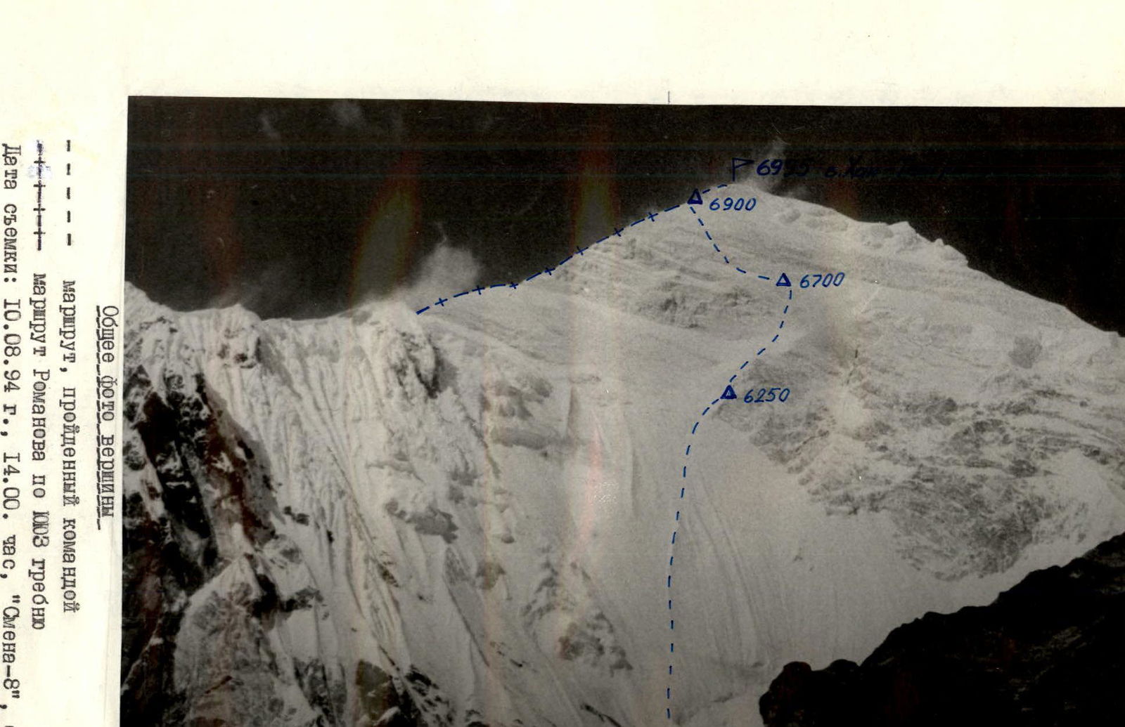
General photo of the summit
- route climbed by the team
-+-+-+- route of Romanov via ridge 1003
Date taken: August 10, 1994, 14:00, "Smena-8" camera, T-43 LOMO lens. Approximate distance to the object — 3 km.
Shooting point on map #1, height 4200 m.
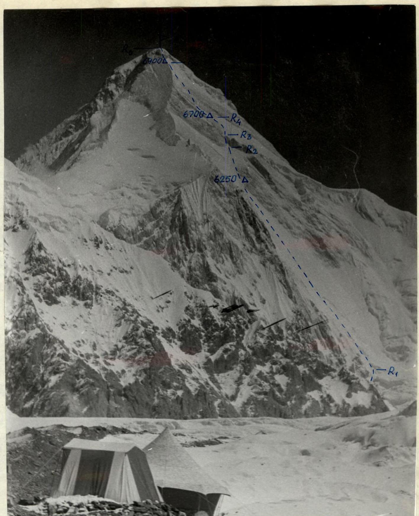
Profile of the wall on the left — team's route Δ — overnight locations. Date taken: August 15, 1994, 12:00, "Industar-51" lens, focal length 50 mm, distance to the object — 9 km. Point on map #3, height 4200 m.
Tactical actions of the team
The team's tactical action plan was developed after observing the wall and studying the intended ascent route in detail through a telescope. Most of the route is an ice wall. It starts at approximately 4500 m and ends around 6500 m. Since modern ice climbing techniques allow for rapid altitude gain, the team's tactical plan focused on passing the route as quickly as possible. The goal was to traverse the ice wall with a 2-kilometer height difference in one day. An overnight stay was planned on the second snowfield under the protection of the summit bastion's rocks. Accordingly, a movement tactic was developed to ensure the necessary working time reserve.
Departure from the 4200 m bivouac:
- at 01:00 allowed safe passage through the icefall (section R0–R1) and the lower part of the wall;
- followed by movement up the ice wall throughout the daylight.
The team decided to use "ice fifis" as it is:
- the fastest,
- the safest,
- and the most energy-efficient method for traversing ice walls.
Special ice screws with handles and extensions were prepared for belaying, significantly reducing the time required compared to regular ice screws. Climbing in pairs also contributed to the high speed of movement.
Movement on ice was done with a shortened rope (20 m) and constant leader change. This style of movement has undeniable advantages over moving on a full-length rope, as:
- Firstly, when advancing 20 m, ice fragments from the "fifi" cannot seriously injure the lower climber in the rope team.
- Secondly, this method of movement is the fastest. In good physical condition, 40 meters of ice (20 m to the belay point and 20 m above it) can be climbed quickly "in one breath," while 80 m is hard to climb without an intermediate rest.
The team successfully completed the task of quickly traversing the ice wall. By 12:00, the ice wall was passed, and the team began to traverse the snow "throat" leading to the rock belt. On this section, the team's movement was complicated by the need to dig through a deep layer of firn to reach the ice for reliable piton belaying. However, a snowfall that started after lunch made further movement impossible. This was due to the fact that on the southeast wall of Khan-Tengri, made of marble, dry snow does not stay on the smooth surfaces but starts to slide down immediately, forming snow rivers. By 15:00, the snowfall intensified, and the team was forced to stop for the night under the protection of the rocks of the first bastion.
On the next day, the team passed the first marble "belt" (section R2–R3) and reached the second snow-ice section (section R3–R4), the left part of which actually consisted of inclined marble slabs covered with snow. To organize reliable belays, it was necessary to clear large areas of snow in search of suitable cracks. After lunch, snowfall resumed, and snow rivers started flowing again. Since organizing a protected overnight stay on the snow slope was not possible, the team continued moving towards the rocks of the summit bastion. However, the snow flowing down the slope sharply slowed down the movement, as finding cracks suitable for reliable piton belays under the snow became extremely complicated.
Taking these factors into account, to ensure safety, the team stopped for the second night, choosing a completely protected spot under a rock overhang of the pre-summit bastion.
On the third day, the team passed the key section of the route — the marble belt of the southeast wall (section R4–R5). A special set of thin rock pitons of various lengths was selected for this section. There was also a set of nuts of various configurations.
The main difficulty of this section lies in:
- the rounded shape of the marble,
- its brittleness,
- and the very small number of cracks suitable for belaying.
With this in mind, the team had a drill and a set of bolt pitons but did not need to use them. The only bolt was driven during the organization of the second overnight stay.
The marble belt was climbed in crampons, as the rock is soft, and crampons held well on the micro-relief. Using "ice fifis" as "skyhooks" in particularly smooth areas proved to be extremely convenient for climbing on marble. This climbing technique allowed the team to pass the entire route without using pitons as intermediate technical equipment.
The first climber moved without a backpack, while the second climber was tied in with two backpacks.
Overall, the marble belt turned out to be steeper and more challenging than it appeared from below.
Upon reaching the southeast ridge, the team considered it necessary to stop for the third overnight stay at around 6900 m because:
- severe frost
- and hurricane-force wind
made the ascent to the summit problematic.
On the next day, the wind and frost did not subside, but since the pre-summit rocks and the snow cap did not present technical difficulties, the team reached the summit and began descending via the classic route to the col and further down to the 4200 m bivouac at 12:00.
Throughout the route, a 1-UIAA rope was used. All overnights were organized using a hammock-sling, allowing for quick organization of lying-down overnights for two people on any terrain.
Communication with observers was organized using a 70RTP2 station according to a schedule. Observers conducted emergency listening during the team's movement every hour.
Observation was carried out:
- with binoculars from the 4200 m bivouac;
- through a 60x telescope from the base camp at 4000 m.
Rescue team composition:
- 4 people were in the base camp;
- 3 people were on standby at 6400 m, where they met the group descending from the summit.
On August 16, 1994, at 17:30, the group descended to the 4200 m camp.
The group adhered to environmental protection measures, leaving no food waste or equipment on the route.
Food and fuel:
- Instant Chinese noodles — 6 packs (600 g)
- Freeze-dried potatoes — 4 packs (400 g)
- Freeze-dried meat — 4 packs (1000 g)
- Freeze-dried cottage cheese — 1 pack (100 g)
- Juice (dry powder) — 6 packs (120 g)
- Tea with lemon (instant) — 1 pack (50 g)
- Sugar — 1 pack (200 g)
- Salt — 50 g
- Chocolate — 8 bars (800 g)
- Dried fruits, raisins, nuts — 350 g
- Fuel (gas) — 2 canisters (1600 g)
Total weight: 5.6 kg
Hot meals were prepared in the morning and evening, with pocket snacks and juice from a plastic flask during the day, except for the first day when a hot lunch was prepared due to the early 01:00 departure.


Total climbing hours — 35
Total pitons used:
- rock — 41
- nuts — 47
- ice — 200
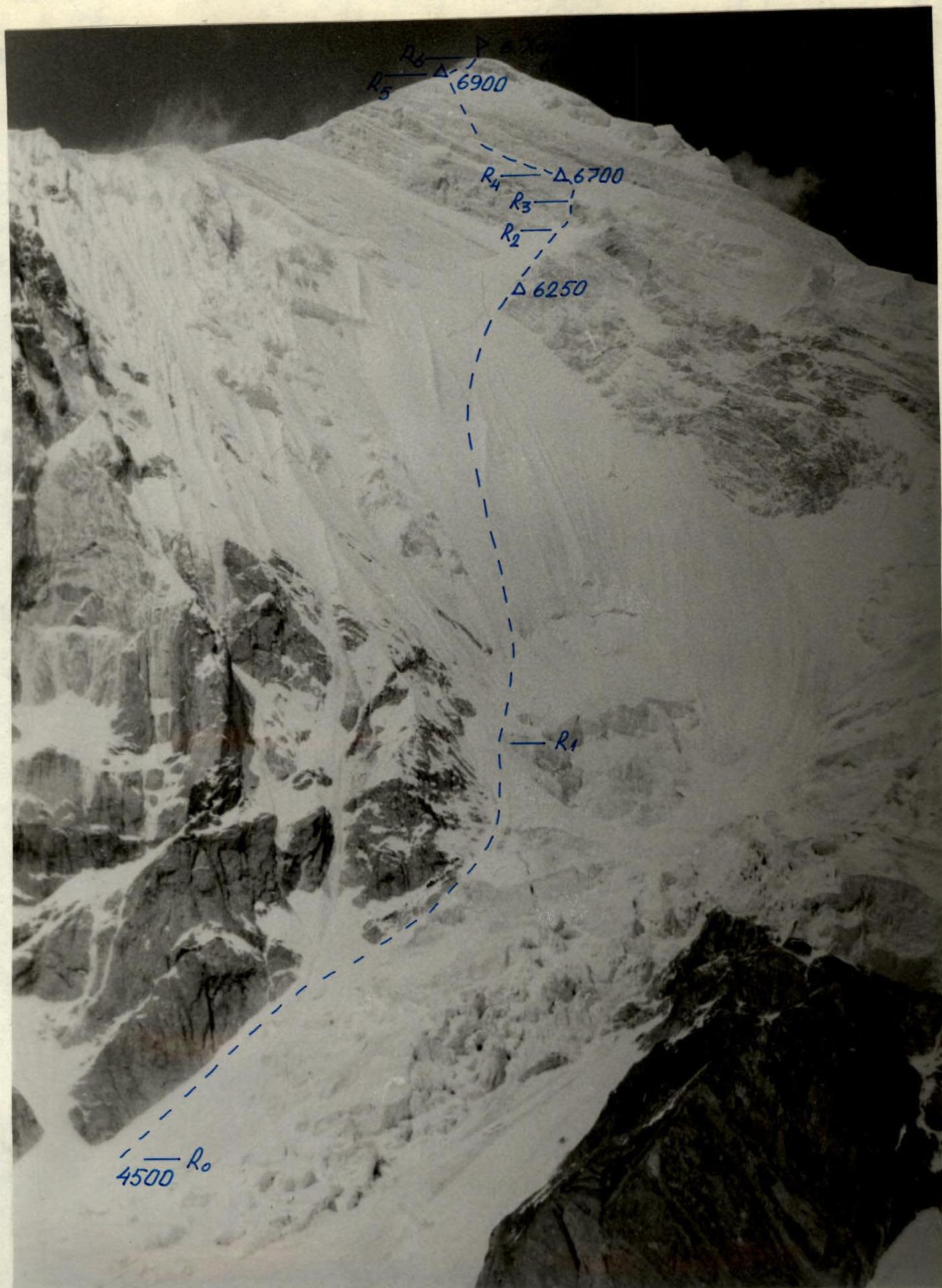
Note: Due to the route's great length and the small number of sections, the diagram is drawn to a scale of 1:10,000.
Route description by sections
Section R0–R1. Movement along a snow-firn slope with a steepness of 40°–45° close to the rocks, bypassing the lower part of the icefall. The slope then transitions into a slightly pronounced gully leading around the upper part of the icefall to the bergschrund at a height of around 4800 m. Alternate climbing, belaying through an ice axe.
Section R1–R2. Ice wall with a steepness of 50°–55°. Alternate climbing using "ice fifis." Belaying through ice screws.
Most of the wall:
- ice is clean
In the upper part of the section, when approaching the first rock belt:
- ice is covered with snow up to half a meter thick
- to organize reliable belaying, it was necessary to dig to the ice
Alternate climbing.
Section R2–R3. First marble belt. Two and a half ropes of difficult climbing. Steepness up to 70°. The relief is quite dissected; there are no particular difficulties with organizing belaying. The first climber in the rope team worked without a backpack.
Section R3–R4. Marble slabs covered with snow. Steepness around 50°. Snow thickness varies from half a meter to 5–10 cm. Belaying is complicated. To organize reliable belaying, it is necessary to clear the slabs of snow in search of cracks. Alternate climbing.
Section R4–R5. Marble bastion. Steepness around 60°–65°, with short walls of greater steepness. The rock is smooth and fragile. There are very few cracks. Thin pitons and small nuts are more suitable for belaying. In particularly smooth areas, movement using "ice fifis" as "skyhooks." Climbing in crampons. The first climber in the rope team worked without a backpack, the second climber moved with two backpacks using a rope.
Section R5–R6. The ascent to the summit via the pre-summit rocks and the snow dome does not present technical difficulties.
Date taken: August 10, 1994, 13:00, "Smena" camera, T-43 LOMO lens, distance to the object — 3 km. Point on map #2, height 4200 m.