Report
On the ascent of Khan-Tengri peak via the eastern counterfort of the northern wall from the North Inylchek glacier.
Team of the CS "Lokomotiv"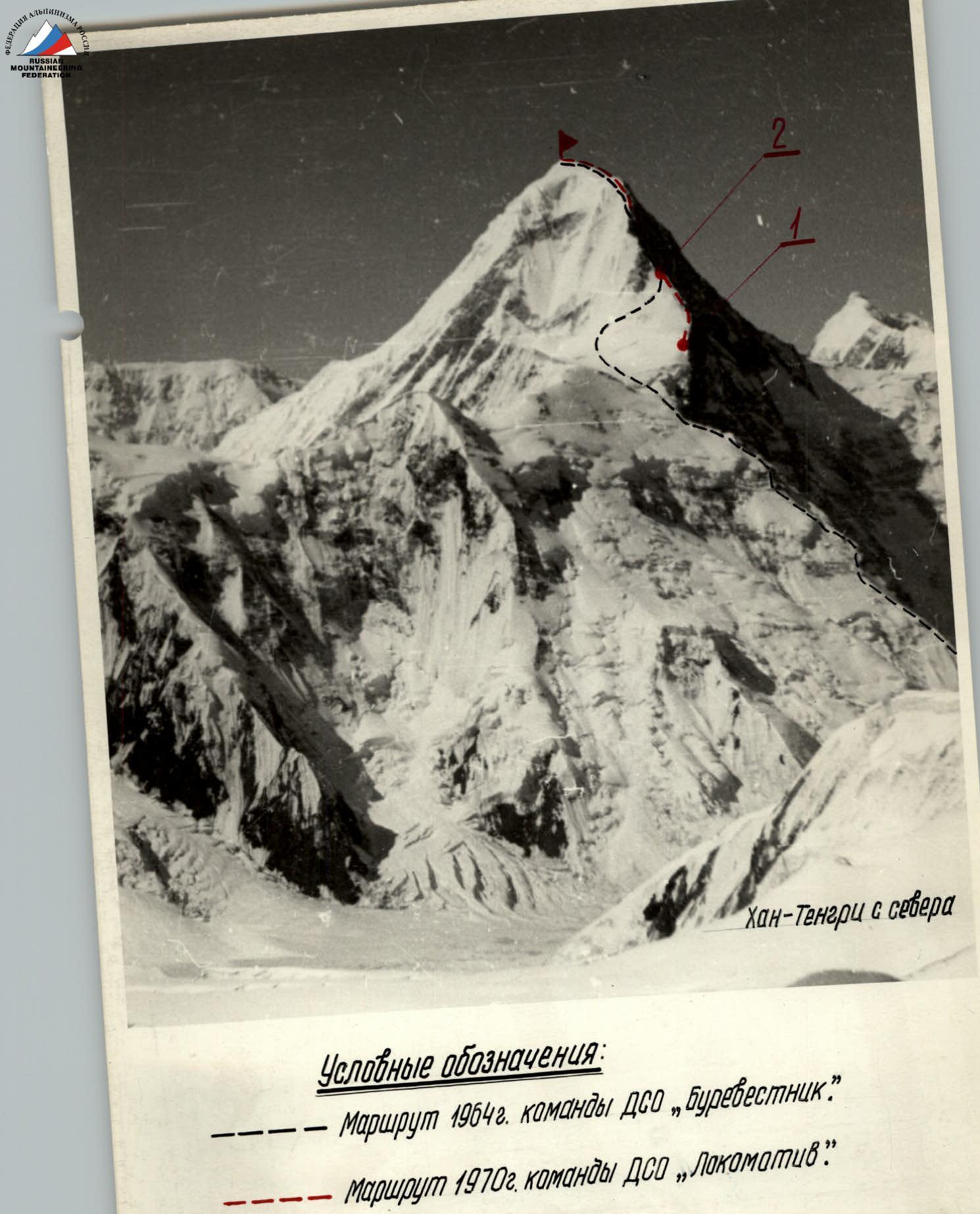
Conventions
- — — Route 1964 of the team DSO "Burevestnik"
- — — — Route 1970 of the team DSO "Lokomotiv"
I. Brief geographical description and sporting characteristics of the ascent object
A. Geography of the area
Khan-Tengri peak is located in the Tengri-Tag range, the second highest range of Tian Shan. The range is stretched in the latitudinal direction and serves as a boundary between the North and South Inylchek glaciers. Khan-Tengri peak is the most significant summit in the range, noticeably standing out among other peaks. The lower part of Khan-Tengri is composed of dark-colored limestones and shales, and the upper part is made of light marble. The boundary of the rocks forming the peak is very visible on the northern wall.
The North Inylchek glacier is relatively flat and less dissected in its upper part. In the area of Khan-Tengri peak, it reaches an altitude of 4000 m above sea level.
The northern wall of the peak:
- is rocky,
- is little dissected,
- is almost sheer,
- has insignificant glaciation.
In the eastern part of the wall, a counterfort stands out, which does not reach the eastern edge of Khan-Tengri but disappears as it transitions into the wall.
B. Sporting characteristics
For the first time, the Tengri-Tag range and its outstanding peak Khan-Tengri were seen by P. P. Semenov in 1857. The foothills of the peak from the south were reached in 1903 by the German geographer and mountaineer G. Mertsbakher. Only in the 30s did a human foot step onto the North Inylchek glacier.
In 1931, the peak of Khan-Tengri was conquered. The first ascenders ascended via the southwestern slope from the South Inylchek glacier (led by M. Pogrebetsky). It took another 30 years to lay new paths on Khan-Tengri. In 1964, the following routes were passed:
- the southern marble edge (led by B. Romanov);
- the first route from the north (led by K. Kuzmin).
In 1967, another path was laid to ascend Khan-Tengri from the north, and for the first time, an ascent to the peak was made as part of the traverse Shatyr — Khan-Tengri (led by B. Studenin).
The route via the eastern counterfort of the northern wall of Khan-Tengri is the first step in mastering one of the problems of our mountaineering — ascending Khan-Tengri via the grandiose, very high-altitude northern wall.
Characteristics of the route:
- Altitude difference (from the bergschrund to the summit) — 3000 m.
- Altitude difference (from the bergschrund to the exit to the eastern ridge) — 2150 m.
- Altitude difference (from the bergschrund to the exit to the Kuzmin route) — 2400 m.
The ascent to Khan-Tengri peak via the eastern counterfort of the northern wall at an altitude of 6400 m joins the route laid in 1964 by K. Kuzmin. Of the total altitude difference of 3000 m, the new route constitutes 2400 m, i.e., 80%. Considering that the newly passed part of the route is the most difficult, and the repeated part is simpler, we believe that the ascent via the eastern counterfort of the northern wall of Khan-Tengri can be considered a first ascent.
II. Climbing conditions in the North Inylchek glacier area
A. Remoteness and exploration of the area
The remoteness of the climbing area from populated areas is a feature of ascents to Khan-Tengri peak. The expedition's path began in Frunze and consisted of a car ride to the village of Maydaadyr, Tupsky district (about 550 km), and a helicopter flight to the North Inylchek glacier. The expedition's base camp was chosen very successfully: under the southern edge of Semenov peak on a ledge, just before the Krasnov glacier. From the base camp to the moraine opposite the North wall of Khan-Tengri, it takes 1.5 hours on foot.
Access to the northern slopes of the peak is complicated by a difficult detour around Mertsbacher Lake. Therefore, until recently, there were only two mountaineering expeditions on North Inylchek (1964, 1967). Now, a new approach to Khan-Tengri has been opened through the Karly-Tau pass, but it is also difficult, and helicopter assistance is necessary to organize an expedition. All expeditions that have been in the North Inylchek glacier area have set out to conquer Khan-Tengri peak. Numerous peaks around the peak await first ascenders and pioneers.
B. Relief
The relief of Central Tian Shan within the USSR is a system of latitudinal ridges. In the east, the latitudinal ridges are intersected by the Meridional ridge. The Tengri-Tag range, the second in height after Kok-Shaal-Tau, separates the basins of the North and South Inylchek glaciers over a length of 40 km. There are 14 peaks in the range, not counting the peaks in the lateral ridges.
Khan-Tengri peak has four pronounced ridges:
- western,
- eastern,
- southwestern,
- southeastern.
The Khan-Tengri glacier is a cirque glacier, broken by two icefalls. There is not a single saddle along the Tengri-Tag range, due to the nature of the rocks composing it. There are 57 glaciers in the range, 21 of which are on one slope. The peaks of Tengri-Tag are more accessible from the south. Ascents from the north are more difficult due to powerful glaciation and snowy conditions.
C. Climate
Central Tian Shan is characterized by a harsh climate with unstable weather. Frequent snowfalls, strong winds, and low air temperatures are serious obstacles on the path to the highest peaks of Central Tian Shan.
Precipitation in the Khan-Tengri area falls only in solid form. During the ascent and delivery period from July 17 to August 19, there were only 10 days of clear, cloudless weather. On other days, at best, there was no snowfall, but such days were few. Mostly, it snowed in the second half of the day.
Khan-Tengri peak is under the influence of local winds, as well as constant upper winds of the western air flow at altitudes of approximately 5500 m. The upper wind speed can reach hurricane force. During the ascent, we repeatedly feared that the wind would tear the tents, but it raged especially after the team reached the plateau on the nights of August 13, 14, 15, and 16, probably due to the more open location of the camp compared to the wall.
Low temperatures greatly hindered progress. According to the thermometer in the group, the temperature mostly fluctuated around 0 °C, which, combined with strong winds, contributes to rapid cooling of the body.
III. Reconnaissance exits and deliveries
-
Route: Bayankol valley — Karly-Tau pass — base camp
- Duration: July 4–13
- Group composition: Nikanorov (leader), Arcishevsky, Volkov, Manshin, Vexler, Yakushev A., Nemchaninov, Oferev, Svitov, Matveev
- Goal: Transition to the base camp.
-
Route: Base camp — Karly-Tau pass
- Duration: July 10
- Group composition: Khudyakov (leader), Kabelsky, Ivanov, Yushkevich
- Goal: Delivery of products to the group going through the Karly-Tau pass.
-
Route: Base camp — assault camp
- Duration: July 12
- Group composition: Khudyakov (leader), Kabelsky, Ivanov, Yushkevich
- Goal: Organization of the assault camp, reconnaissance.
-
Route: Base camp — assault camp
- Duration: July 15
- Group composition: Khudyakov (leader), Kabelsky, Yakushev, Volkov, Ivanov, Yushkevich, Arcishevsky, Manshin
- Goal: Delivery of products and equipment to the base camp, reconnaissance.
-
Route: Base camp — assault camp — eastern counterfort of the North wall of Khan-Tengri.
- Duration: July 16–17
- Group composition: Arcishevsky (leader), Kabelsky, Manshin, Volkov
- Goal: Reconnaissance of the route, delivery.
-
Route: Base camp — assault camp — eastern counterfort of the North wall of Khan-Tengri.
- Duration: July 17–18
- Group composition: Khudyakov (leader), Yakushev, Ivanov, Yushkevich
- Goal: Reconnaissance of the route, delivery.
-
Route: Assault camp — eastern counterfort of the North wall of Khan-Tengri.
- Duration: July 19–20
- Group composition: Khudyakov (leader), Arcishevsky, Ivanov, Volkov, Yushkevich, Manshin, Yakushev, Kabelsky.
- Goal: Delivery of equipment, products, reconnaissance. All groups coped with the tasks set before them.
IV. Organizational and tactical plans for the ascent
Before leaving for the mountains, a general plan for the expedition was adopted, which turned out to be correct and was largely implemented. Its main points:
- July 1–6 — transportation of people, cargo from Frunze to the village of Maydaadyr, Tupsky district — base camp on the North Inylchek glacier.
- July 7–9 — deployment of the base camp.
- July 10–31 — training, deliveries, acclimatization hikes, reconnaissance.
- August 1–15 — ascent to Khan-Tengri peak.
- August 15–19 — evacuation of the expedition.
Upon detailed familiarization with the route, the duration of the ascent was increased.
After gathering information about the ascent route to Khan-Tengri, observing the route during the stay in the base camp and assault camp, and conducting reconnaissance, the following was revealed:
-
The climate of Central Tian Shan in the Khan-Tengri area is unfavorable for climbing:
- frequent snowfalls,
- strong winds,
- fogs,
- frost.
-
The ascent route via the eastern counterfort of the northern wall presents great difficulties as a technically complex route on a seven-thousander.
-
The route is extremely long: the altitude difference from the bergschrund to the summit is 3000 m.
-
There are practically no platforms for overnight stays on the route. To build them, it takes 4–6 hours.
Considering all this, a tactical plan for the ascent was chosen with route processing from sequentially created intermediate camps with further relocation of these camps upwards.
In accordance with the plan, equipment was selected:
- a large number of ropes (20 pieces);
- pitons (125 pieces);
- food and fuel for 24 days.
The subsequent passage of the route confirmed the correctness of the chosen tactics in the harsh conditions of Central Tian Shan, which made it possible to pass this extremely difficult route with a sufficient margin of safety.
Communication with the base camp was carried out using the "Nedra-P" radio station, and with Przhevalsk — using a long-wave radio station. The composition of the rope teams was organized so that each team could solve technical tasks arising during the ascent. Distribution of rope teams:
- Khudyakov — Ivanov
- Yakushev — Yushkevich
- Manshin — Arcishevsky
- Volkov — Kabelsky
V. Composition of the assault group
Before leaving for the mountains, the following composition of the assault group was planned:
- Khudyakov O.
- Ivanov R.
- Yushkevich V.
- Yakushev A.
- Yakushev Ya.
- Zysin S.
- Arcishevsky Yu.
- Volkov R.
Yakushev Ya. and Zysin S. could not participate in the expedition, and instead, Manshin Yu. and Kabelsky L. were included in the main team.
The final composition of the team was as follows:
- Khudyakov O. — Master of Sports of the USSR — team captain
- Ivanov R. — Master of Sports of the USSR
- Yushkevich V. — Master of Sports of the USSR
- Kabelsky L. — Master of Sports of the USSR
- Arcishevsky Yu. — Master of Sports of the USSR
- Yakushev A. — Candidate for Master of Sports
- Volkov R. — Candidate for Master of Sports
- Manshin Yu. — Candidate for Master of Sports
Data on the participants of the assault:
| № pp. | Surname, initials | Year of birth | Profession | Alpine qualification | Alpine experience | Home address |
|---|---|---|---|---|---|---|
| 1. | Khudyakov Oleg Vladimirovich | 1938 | engineer | Master of Sports | 12 | Leningrad K-249, prospect Nauki, 30, korp. 1, kv. 381 |
| 2. | Ivanov Ruf Ivanovich | 1929 | teacher | Master of Sports | 22 | Leningrad, pr. Lensoveta, 60, kv. 10 |
| 3. | Yushkevich Vladimir Sergeevich | 1932 | engineer | Master of Sports | 17 | Leningrad, ul. Borovskaya, d. 2, kv. 79 |
| 4. | Arcishevsky Yuri Yuryevich | 1940 | engineer | Master of Sports | 12 | Rostov-on-Don — 29, ul. Serzhanova, d. 1, kv. 6 |
| 5. | Kabelsky Leonid Davidovich | 1933 | engineer | Master of Sports | 16 | Moscow, 1 Yuzhno-Porotovy pr. d. 14/32, kv. 3 |
| 6. | Yakushev Alexey Yakovlevich | 1940 | engineer | Candidate for Master of Sports | 11 | Leningrad, pr. Veteranov, d. 94, kv. 52 |
| 7. | Volkov Ratmir Petrovich | 1939 | engineer | Candidate for Master of Sports | 11 | Rostov-on-Don — 58, pr. Stachki, d. 199/2, kv. 74 |
| 8. | Manshin Yuri Pavlovich | 1939 | teacher | Candidate for Master of Sports | 11 | Rostov-on-Don — 9, Novocherkasskoye shosse, d. 22, kv. 26 |
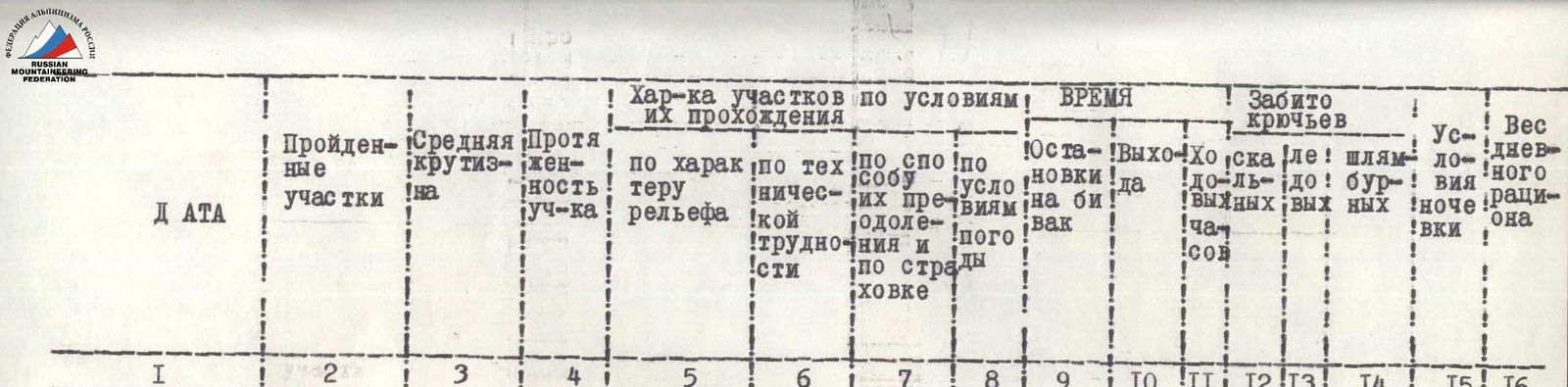
Table of main characteristics of the ascent route
| Ascent route | — eastern counterfort of the northern wall of Khan-Tengri |
|---|---|
| Altitude difference of the route | — 3000 m |
| Including the most difficult sections | — 2000 m |
| Steepness of the route | — 70–75° |
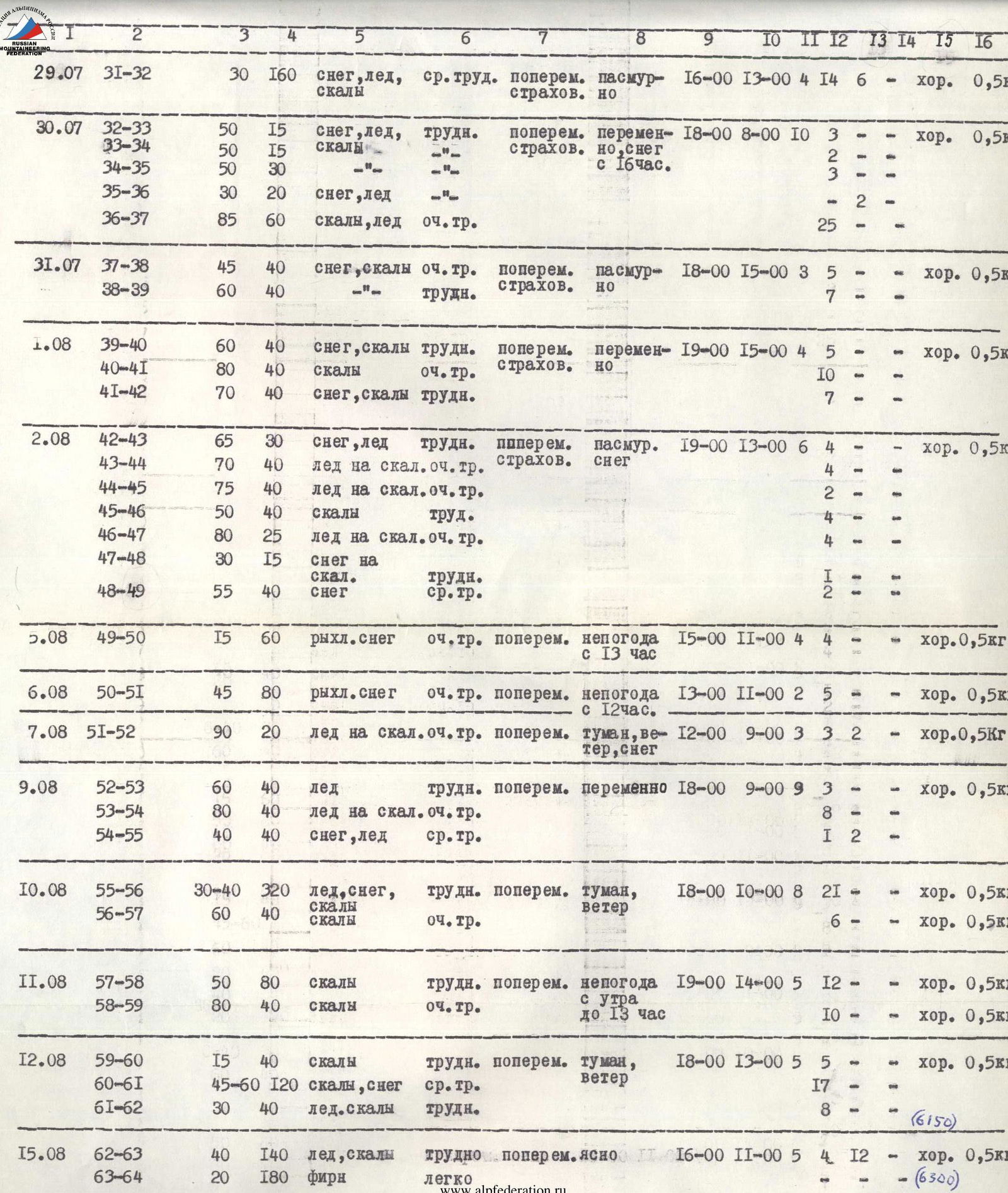
VI. Order of passage of the route
July 16 — At 13:00, a group of four: Arcishevsky, Manshin, Volkov, Kabelsky, left the base camp for the assault camp.
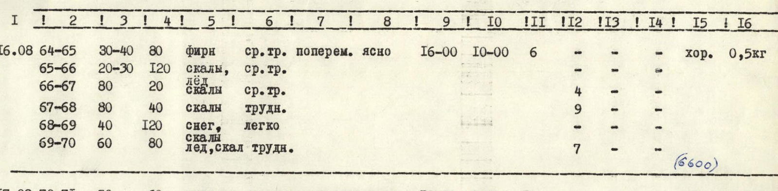
July 17 — Departure at 7:00. Along the Khan-Tengri glacier, avoiding crevasses and avalanche deposits, we reach the place where we overcome the bergschrund in 1.5 hours. This is not the easiest but the safest place, which is not blocked by avalanches. Further, the route includes:
- A steep ascent along a sheer ice wall (R0–R1) and then along an ice slope (R1–R2).
- A long traverse of the ice slope to the right in the direction of protruding rocks (R2–R3).
- Having passed the rocks, movement continues straight up, heading towards the beginning of a rocky massif (R3–R4).
- Movement up the rocks, sometimes with ice between the rocks (R4–R6).
- Again, a traverse to the right (R6–R7), after which the path becomes more complicated (R7–R8).
- After a short sheer section (R8–R9), it gradually becomes easier (R9–R10).
- A section of simple but destroyed rocks (R10–R11) leads to an ice couloir (R11–R12).
- Having overcome the couloir, we again find ourselves on a section of destroyed rocks (R12–R13).
At the couloir, we cut out a platform for camp № 1 in the ice and rocks. The descent to the assault camp took 1.5 hours. The group of four: Khudyakov, Ivanov, Yushkevich, Yakushev, moved to the assault camp.
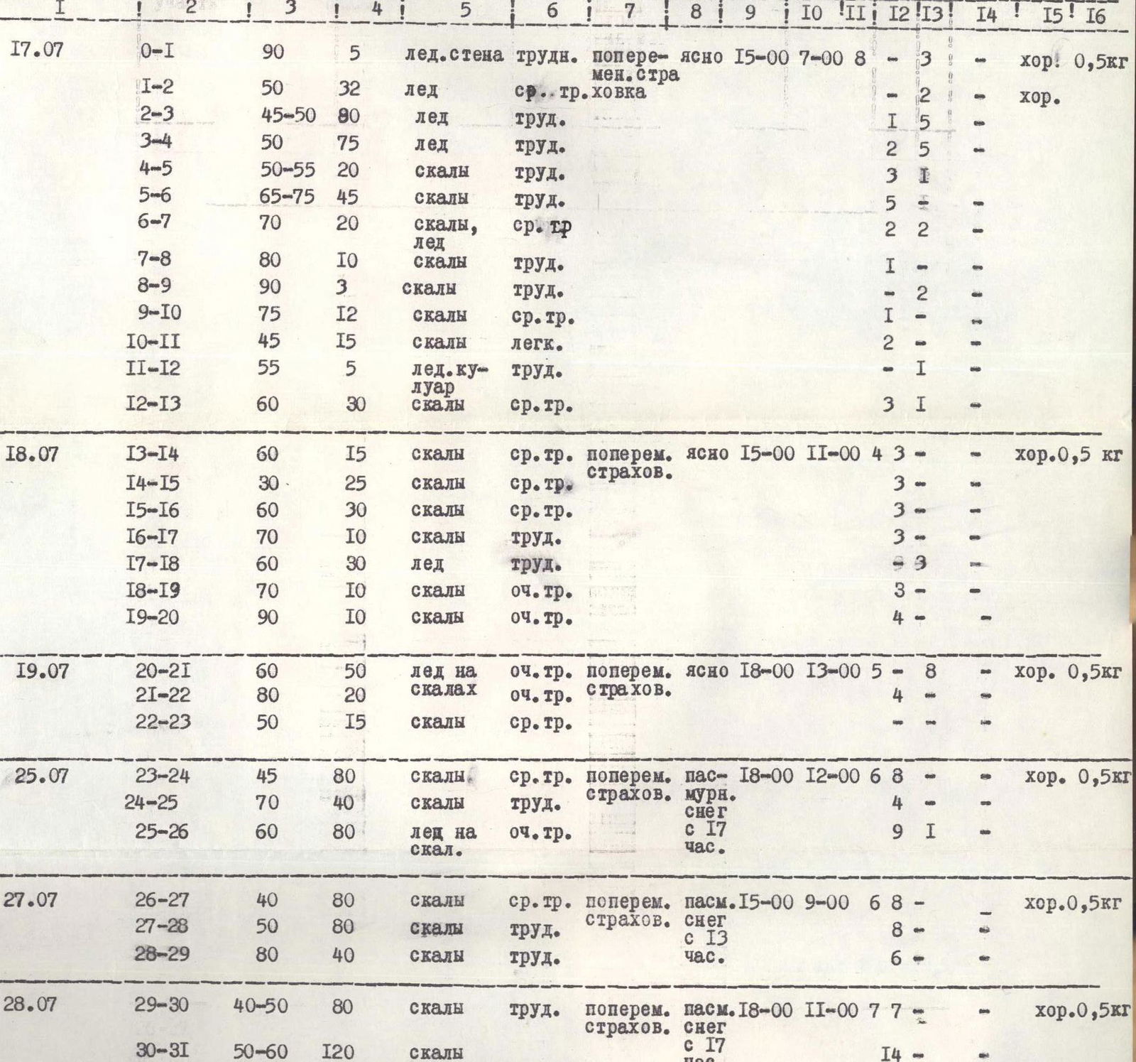
July 18 — The second group of four departed at 6:00. By 11:00, they reached the end of the hung ropes. Further:
- A small section of rocks (R13–R14) is overcome straight up.
- Moving to the right, we bypass a large rocky ledge composed of destroyed rocks (R14–R15) and exit to the base of a not clearly expressed couloir.
- Having passed the couloir (R15–R16), we find ourselves on the edge of a snow-ice slope (R16–R17), from which rocks covered with rim ice protrude in places.
- After the rocks, there is an ice slope covered with snow (R17–R18).
- Two very difficult ice-covered rocky walls (R18–R20), passed using ladders and pulling up backpacks.
The descent to the assault camp took 2 hours.
July 19 — Departure at 6:00 by the entire team. By 13:00, they reached the end of the hung ropes. Further:
- After the rocky walls, there is a steep slope (R20–R21) consisting of ice lying on rocky slabs and covered with snow.
- Steep, ice-covered, difficult rocks (R21–R22) finally lead us to the counterfort.
- A small section of rocks (R22–R23) and a descent to the assault camp.
July 20, 21, 22 — Bad weather. We sit in the assault camp.
July 23, 24 — Clearing. The weather starts to improve.
July 25 — Departure at 6:00. Backpacks are very heavy. Bad weather has covered the tracks. The ropes are icy and snow-covered. Practically, the ice slope is passed again. The beginning of processing a new path is at 12:00. Further:
- After exiting the counterfort, we descend to the right of the ridge line and move along the rocky wall of the counterfort (R23–R24).
- Then the rocks become steeper (R24–R25) and lead to a rocky couloir filled with ice, which goes left — up onto the counterfort (R25–R26).
- Having passed the couloir and two ropes along the counterfort, we find ourselves under the "small wall," near which we lay out two platforms for camp № 2.
Four people descend to spend the night in camp № 1, and four spend the night in camp № 2.
July 26 — Departure at 8:00. Route processing is not carried out. Everyone is engaged in transferring cargo from camp № 1 to camp № 2. Overnight stays are at the same places.
July 27 — Departure at 9:00. From the overnight stay, we bypass the "small wall" on the right (R26–R27). After the bypass, the rocks become steeper (R27–R28). Having passed another rope of steep and wet rocks (R28–R29), we are forced to return to camp № 2 due to bad weather starting in the second half of the day. Overnight stay for the entire team is in camp № 2.
July 28 — Departure at 9:00 for processing. A traverse to the right along the shelves (R29–R30) and a long, difficult ascent along wet, destroyed, and partly icy rocks, bypassing the "big wall," again leads us to the counterfort (R30–R31) above the "big wall." On top of the ridge, two platforms for tents are cut out in the ice — camp № 3. Overnight stay is in camp № 2.
July 29 — Departure from camp № 2 for processing and pulling cargo to camp № 3 at 10:00. By 13:30, we reached the end of the hung ropes. From the platforms, the path goes along the ridge (R31–R32). The ridge is icy, covered with snow. Rock outcrops are encountered in places. Having reached the "gendarme," we descend to spend the night in camp № 2.
July 30 — Departure at 9:00. We finally move to camp № 3. Further processing of the route is carried out. Ascent to the "gendarme" (R32–R33). The rocks are destroyed, covered with snow. Descent from the "gendarme" (R33–R34) and again ascent (R34–R35) along a snow-ice "knife" (R35–R36), very sharp, steeply dropping on both sides. Snow on ice holds very poorly. The "knife" leads to a very difficult rocky-ice wall, steep, partly overhanging, and in the upper part turning into a sheer couloir covered with rim ice (R36–R37). The wall is passed using artificial support points and pulling up backpacks.
July 31 — Departure at 10:00. We make a delivery of cargo to the end of the passed ropes and further processing of the route. After the wall, we exit onto the edge of a rocky slope covered with a layer of loose snow up to half a meter thick. To organize belays, we have to:
- dig through the snow;
- drive in rock pitons.
Movement along the edge (R37–R38) is slow. After a snowfall, dry avalanches go down the slope. Avalanche danger.
— We exit to a section of rocks (R38–R39). The rocks are steep, with less snow there. There are no platforms for overnight stays. Overnight stay is in camp № 3.
August 1 — Departure at 9:00, continuing processing. Rocks covered with snow (R39–R40) lead to steep, very difficult rocks covered with rim ice (R40–R41). Ladders are used. Another rope along rocks covered with snow, and there is a place where you can cut out a platform (R41–R42). Here, on the rocks, we build a control cairn.
August 2 — Departure at 10:00, we move from camp № 3 to camp № 4 with one tent, as there is no more space there. We continue processing. From the overnight stays, a sharp snow-ice "knife" (R42–R43) leads to a wall covered with rim ice (R43–R44), then the wall becomes steeper, with fewer holds (R44–R45). After that, a slight flattening (R45–R46) leads to a very difficult section — an ice couloir (R46–R47). The couloir is passed using artificial support points and pulling up backpacks. Under the ice, stones protrude in places. The ice is covered with snow. After the couloir, we move along snow lying on rocks (R47–R48), after which a steep snow "forehead" (R48–R49) leads to a place where you can cut out platforms for camp № 5. Overnight stay is in camps № 3 and № 4.
August 3 — Bad weather, hunkering down.
August 4 — Bad weather. Hunkering down.
August 5 — Bad weather catches us in the morning during the relocation of the lower tent from camp № 3 to camp № 5, bypassing camp № 4. A small section of deep loose snow is processed (R49–R50). After a snowfall, dry avalanches are possible. The snow is dry, and when moving, a trench is dug up to a meter deep. Forward progress is stopped due to strong bad weather. Overnight stay is in camps № 4 and № 5.
August 6 — The lower tent is relocated to camp № 5. Strong bad weather allows us to pass only one and a half ropes through deep loose snow lying on rocks (R50–R51) and approach a steep rocky "forehead." Overnight stay is in camp № 5.
August 7 — Bad weather forces us to return from processing, having passed 20 m of a very difficult chimney-couloir (R51–R52). Hands and feet are freezing. Hunkering down.
August 8 — Bad weather. Hunkering down.
August 9 — We depart for processing at 9:00. After a short, very difficult couloir passed the day before, there is a steep ice slope (R52–R53) with frequent stones frozen into it, which crumble and break when stepped on. In places, there are snowdrifts and a rocky monolith. The slope leads to a second, even more difficult couloir (R53–R54), which is passed using artificial support points and pulling up backpacks. Both couloirs are avalanche-prone (after a snowfall — with dry avalanches), very steep, and in places, narrowing, turn into a vertical chimney. There is rim ice on the rocks. Another rope of a relatively easy slope (R54–R55), and on the slope, you can cut out a platform for tents — camp № 6, into which one tent from camp № 5 is relocated.
August 10 — Departure at 10:00. The lower tent is relocated to camp № 6. Despite bad weather and cold, we continue processing. From the overnight stays — a rope along an ice slope strewn with snow, and then we head in the direction of a couloir bounded on the right and left by large rocky "foreheads" (the "forehead" on the right is larger than on the left). To the couloir — 4 ropes. Having entered the couloir, we move about 20 m, then turn sharply left onto its wall and exit onto the ridge of the couloir, along which we ascend to the place where it, in its upper part, abuts against the wall (R55–R56). Under the wall, we cross the couloir to the right. Another rope (R56–R57) of very difficult climbing along the wall, devoid of holds, and we exit onto a small platform above this wall. After a snowfall, this path is avalanche-prone, as dry, loose avalanches flow down the slope in a continuous stream.
August 11 — Departure for processing at 8:00. After the rocky wall with a small platform at the top, the path goes to the right — upwards along a large crack in the rock (R57–R58). In places, it becomes very steep and turns into a "chimney." The crack ends with a small two-tiered ledge. From the ledge, we move straight up the wall (R58–R59) to a shelf extending onto a rocky massif. Climbing here is very difficult; we use artificial support points and pull up backpacks. The weather is bad in the morning, but in the second half of the day, it deteriorates significantly, forcing us to return to camp № 6.
August 12 — The weather is bad in the morning. Nevertheless, we continue working. One tent is set up under the wall in the upper part of the couloir passed the day before. Here is camp № 7. Route processing continues. A difficult traverse along a shelf to the left with a small gain in height (R59–R60). The shelf is sloping downwards, partly narrow, and covered with ice. After the shelf, the path goes to the left — upwards along a rocky massif. The path is logical (R60–R61) and leads to the place of exit onto the eastern ridge of Khan-Tengri peak. This place is an almost sheer slope turning into a couloir. The slope needs to be traversed to the left — upwards (R61–R62) to a small flattening of the ridge. The exit to the ridge is via a chimney. Climbing is difficult. The slope is covered with snow and ice. The ridge is sharp. With difficulty, we lay out a platform for camp № 8. Overnight stays are in camps № 6 and № 7.
August 13 — We relocate: the upper tent to camp № 8, the lower one to camp № 7. It is dangerous for eight people to go along this section due to the possibility of dislodging a stone onto those below. In the second half of the day, there is strong bad weather. Hurricane-force wind. It is especially hard for those above, sleeping on the ridge.
August 14 — The weather has finally improved, but there is a strong wind. We descend from the ridge to a flat place and set up tents. We help our comrades below to relocate upwards.
August 15 — We depart at 11:00. We ascend along the slope to the place of exit onto the ridge and continue moving upwards along it. At first, there is a steep ice slope (R62–R63). Rock outcrops are encountered in places. Then the ridge becomes more gentle (R63–R64). Ascents alternate with flat sections. Not reaching the overnight stay under the "red rocks," we organize camp № 9 in a hollow on the ridge.
August 16 — Departure at 10:00. We ascend along the ridge to the "Red rocks" (R64–R65) and traverse the slope to the right — upwards (R65–R66). Then there is a section of strongly destroyed rocks (R66–R67) and a rope of difficult climbing straight up (R67–R68). Several ropes of easy climbing (R68–R69) and again difficult. We exit onto the ridge along the slope and in the upper part — along a sheer wall (R69–R70). Overnight stay is for one tent. We had to work hard to set up two. Camp № 10. At night, a hurricane-force wind knocks down the tents.
August 17 — The weather is good in the morning, but very cold. We depart at 8:00. From the overnight stay, at first, there is a slope covered with snow lying on ice (R70–R71). The slope then becomes steeper (R71–R72). Rock outcrops begin to appear, strongly destroyed. After that, it becomes more gentle again, a snowy slope (R72–R73). Stepping footholds are made with great difficulty. The last steep rocks before the summit (R73–R74) are covered with ice and partly sheer. The summit ridge (R74–R75) is quite long. The height is gained slowly. Ascents alternate with descents. At 14:30, we reach the summit of Khan-Tengri. Descent to the overnight stay in camp № 10.
August 18 — Departure at 8:00. We descend along the K. Kuzmin route, bypassing the 6000 m plateau. We spend the night on the middle rock outcrops of the ascent to the plateau by the Kuzmin group.
August 19 — We descend to the base camp.
VII. Overall assessment of the actions of the assault group participants
All participants of the assault group showed themselves to be excellent physically and technically trained mountaineers. The rope teams were organized such that daily rotation of the leading pair was carried out. This allowed for clear work organization on the ascent and provided the necessary rest when needed.
VIII. Data on the auxiliary group
The auxiliary group of the expedition included mountaineers of sufficiently high qualification. During the ascent of the main group, the auxiliary group carried out visual observation of the main group and maintained radio communication with it. If necessary, the main group could use the auxiliary group as a rescue team, as six people from it could go to the summit of any category up to the sixth.
Group composition:
- Nikanorov S. I. — Master of Sports of the USSR — group leader
- Matveev A. A. — Master of Sports of the USSR
- Nemchaninov V. A. — Candidate for Master of Sports
- Vexler V. Ya. — Candidate for Master of Sports
- Oferev V. V. — Candidate for Master of Sports
- Likhachev Yu. Yu. — Candidate for Master of Sports
- Fedorov S. A. — 1st sports category
- Svitov V. A. — 1st sports category
- Davydov V. V. — 3rd sports category, radio operator
- Lebedev O. A. — 3rd sports category, doctor
IX. Additional data
According to the application, the main route of the team was the ascent via the northern wall of Khan-Tengri. Based on observations of the declared route, it was found to be an objectively dangerous route due to its obvious avalanche danger in the middle part of the wall. Therefore, it was decided to ascend via the alternative route — the eastern counterfort of the northern wall of Khan-Tengri — as objectively safer. Further observation of the wall during the passage of the route confirmed the correctness of the decision made.
The route via the eastern counterfort of the northern wall of Khan-Tengri is a very complex combined route. Significant difficulties are presented by the overcoming of rocky and icy sections. Moreover, both rocks and ice are covered with a layer of snow, which greatly slows down progress and complicates the organization of belays. In addition:
- Rocks are often covered with rim ice.
- There are chimney-couloirs, the bottom of which is always icy.
- On the route, there are sections of slopes where snow lies on a rocky or icy base.
- After snowfalls, the slopes become avalanche-prone.
- Avalanches of dry snow flow down them.
The large altitude difference between the lowest and highest points of the route, as well as the high absolute height of the summit, requires taking a significant amount of food and equipment. The real possibility of being delayed on the ascent due to bad weather further increases the weight of backpacks.
Frequent snowfalls, wind, and cold are characteristic features of the ascent to Khan-Tengri via this route. Special attention should be paid to insulating hands and feet. High-altitude boots can be used only on the lower part of the route (up to the 6000 m plateau) with mandatory insulation. Shelters can be used from the plateau due to the possibility of dampening.
The lack of overnight stay sites