ascents made during the 1975 USSR Alpine Climbing Championship.
- Ascent category — high-altitude.
- Ascent region — Central Tian Shan.
- Ascent route with indication of peaks and their elevations.
Eastern buttress of the North face of Pik Khan-Tengri (6995 m). 4. Ascent characteristics: elevation gain — 2845 m.
average steepness — 51° (5700 m). Length of the most difficult sections — 930 m. 5. Pitons driven: rock — 78,
ice — 10, bolt — none.
- Total hours of climbing — 68.5.
- Number of bivouacs and their characteristics.
10 bivouacs, lying down and semi-reclining. 8. Team name — Togliatti City Committee F.K. and S. team.
- Surname, first name, patronymic of the team leader, participants, and their qualification.
- Benkin V.S. — Master of Sports, team leader.
- Kazayev Yu.V. — Master of Sports, deputy leader.
-
Mavrin B.M. — Candidate for Master of Sports, participant.
-
Pshenichnikov A.A. — Candidate for Master of Sports, participant.
-
Statsky L.N. — Candidate for Master of Sports, participant.
-
Sharov O.Ya. — Candidate for Master of Sports, participant.
-
Team coach — Benkin V.S.
-
Dates of departure and return.
- July 17, 1975 — July 30, 1975.
Ascent log.
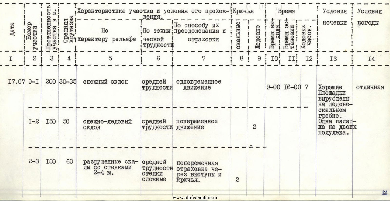
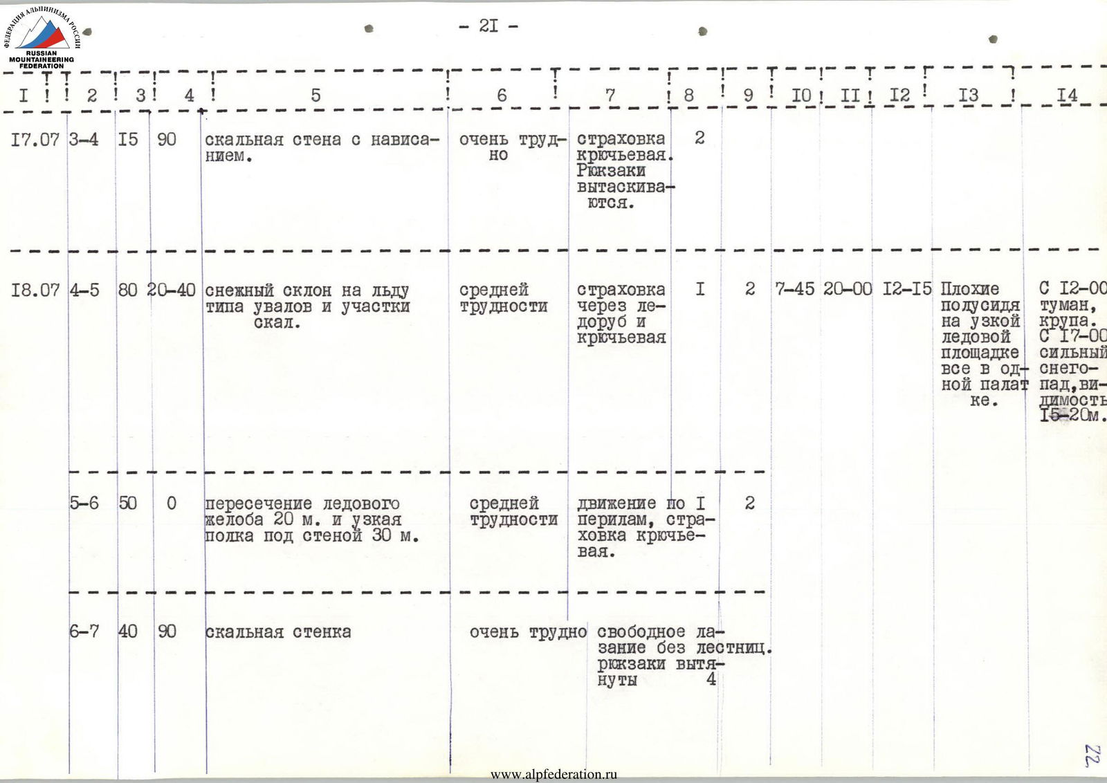
July 17, 1975. At 8:00, we leave the base camp along with observers Vitkalov V. and Lebovich E., who will drop the extra rope ends and some crampons from under the rocky outcrop. We bid farewell to the Muscovites and the Committee Representative, Shirokov Yu.M. There is up to 30 cm of fresh snow on the moraines and glacier, but it has frozen and is easy to walk on.
At 9:00, we are at the lower snowfield, conduct a final inspection of the slope, and begin ascending it towards the lower rocky outcrop where the lower end of the suspended rope is anchored. The distance to the outcrop is 350 m over snow on ice, with the upper 150 m being no less than 50° steep. The fresh snow has frozen and holds our weight, so we move reliably but without stopping, knowing the slope can become hazardous as it warms up and potentially triggers avalanches. We reach the fixed ropes, hand over two ropes and three pairs of crampons to the observers, watch them descend quickly to the glacier, and begin our ascent along the fixed ropes: steep, crumbling rocks, an icy slope, smooth rocks again, and finally, a familiar sheer wall, even slightly overhanging for 15 meters, which Oleg Sharov had virtuously climbed the day before without ladders. By 16:00, everyone gathers near the snow-pressed tent. Quick snack. The duo, Sharov O. and Pshenichnikov A., depart to process the approach to the edge, while the rest restore the tent and struggle to carve out a platform in the ice and crumbling rocks for a second tent. We manage to create one for two people, semi-reclining. The weather has been favorable so far: no usual snowfall throughout the day. The duo processed 100 m, including a steep icy couloir before the edge. It became clear that the exit to it is only feasible from the right via a sheer wall, as the left path along the icy chute is often hit by ice debris and avalanches.
Communication at 20:00, lights out. July 18, 1975. At 7:45, the trio of Pshenichnikov A., Sharov O., and Mavrin B. departs. 20 minutes after the radio check-in, the rest follow. 2 ropes along a deep snowy slope 20–45° with sections of rocks, we move upwards and to the right towards the icy chute before the rocky wall. We chop steps in the chute. Ascending it is dangerous due to falling ice fragments from above and avalanches. We cross the chute one by one, quickly along the fixed ropes (20 m), and move onto a narrow snowy ledge under the protection of the rocky wall. The wall is sheer. Oleg Sharov goes first without a backpack. In his characteristic smooth manner, pausing only to clear snow and drive in the next piton, he traverses 40 m vertically and reaches an inclined ledge that can accommodate no more than two people. Above his head is a rocky overhang. Another 40 m of ice-covered, fairly smooth rocks upwards and to the right, and through a 4-meter overhanging wall, we find an exit onto the ridge (edge). We drive pitons where possible, though there are few suitable spots. We haul the backpacks in three stages. The first backpack reaches the ridge at 16:30; the entire team and all backpacks are in place only by 20:00. During this time, the first rope processed a 35-meter wall, ice-covered and quite smooth. There are few cracks; we managed to drive only three channel pitons. Almost the entire day (since 12:00) is marked by dense fog, sleet, and from 17:00, heavy snowfall.
Communication with the base at 20:00; by 21:00, we carve out a narrow platform in the ice along the ridge's rocks and bivouac semi-reclining in one tent.
July 19, 1975. Snowfall continued throughout the night; after 2 hours, we have to emerge and clear the snow from the tent. There is up to 30 cm of snow on the ledges. Snow does not stick to the wall. After an uncomfortable night, we depart at 10:00. On the wall, even on the previously anchored rope, everyone goes without backpacks. Beyond the wall, there are 120 m of a steep snowy ridge. The snow is dry, very deep, lying on slabs, and slides down upon movement. We proceed extremely cautiously. Insurance is only through rocky outcrops on the ridge (every 30–40 m). By 16:00, we approach a large rocky tower. There's no space for a bivouac.
The duo, Sharov O. and Statsky L., remain to process the tower, while the rest descend 60 m down the ridge and set up a bivouac for two tents. The duo catches up by 19:00.
They processed 70 m of the rocky wall and ridge, driving 5 pitons. The weather today is good, strong wind, but excellent visibility. Communication is stable.
July 20, 1975. The night passed calmly. At 8:00, we continue along the deep snow on the ridge towards the tower, then 50 m along rocks and deep snow, traverse a gendarme with a 40 m elevation gain to the left. We proceed parallel to a steep icy chute. Again, upwards onto the ridge via snow and snow-covered, crumbling rocks because going left is not feasible: chest-deep snow, 60° steepness, and no insurance. On the ridge, there's another wall. Oleg leads again. Ascending the wall involves a 20-meter chimney filled with ice and steepness up to 85–90°, movement in opposition, then a 30-meter internal corner at 75° with ice and slabs on its edges, and 50 m of rocks at 70–75° with narrow snow and ice-covered ledges. The group takes 7 hours to traverse these 100 m with the hauling of backpacks. 12 channel pitons are driven. Only Oleg could have passed here without using ladders!
We emerge onto a sharp snowy ridge. 20 m upwards (destroying it with our bodies) and along a 5-meter rocky wall, we reach the top of the gendarme. Behind it, on a 2-meter snowy col, we struggle to set up tents. 17:00.
The duo reaches the edge of the snowy ridge by 18:30, processing 80 m of a corniced snowy ridge consisting of three humps with steepness up to 50°. Insurance is through pitons in rocky outcrops along the right edge of the edge. From 18:00, snowfall, later a thunderstorm, dense fog. Communication with the base is good.
July 21, 1975. We rise at 6:00. Thunderstorm, snowfall. After the radio check-in at 8:15, we depart in dense fog. We proceed along a corniced ridge for 80 m under the rocks. Yesterday's trench is gone; the snow-covered rope indicates that people were here before. There's over 1 m of snow. Moving with backpacks is challenging. To the right of the rocky wall of the next ascent, we traverse 40 m along snow with piton insurance on the rocks.
From 10:00, a strong, cold wind, dense snowfall; it feels like the wind is blowing from all sides simultaneously — it's hard to breathe. By 13:30, we decide to set up a bivouac on the ridge under the rocks. Within 2.5 hours, two satisfactory platforms are ready. Simultaneously, the rope team processes the rocky ascent and the corniced ridge, which now leads left — towards Kuzmin's route. By 17:00, everyone is in tents, and after a brief clearing, strong gusty winds and snowfall resume. Via radio, we learn that many groups spent the day sheltering.
July 22, 1975. The weather is wonderful. At 8:30, we begin ascending along fixed ropes, alongside rocks, through deep snow towards the top of a giant triangle. This is the end of the edge. There's no sign of previous tracks or trenches — the night's storm has smoothed everything.
The ridge leads left upwards, sharp, with steep slopes on both sides. Snow slides down in both directions. Each step requires attention. The section is 190 m long, with an average steepness of 30°.
On the ridge:
- several sheer rocky walls of 8–15 m with rather complex climbing,
- the walls allow for reliable insurance,
- we drive pitons into the rocks.
The ridge becomes practically horizontal, with cornices on the north side. We proceed 100 m through deep snow along the right (southern) slope. We emerge onto a wide snowy field. 13:00 — sunshine, warmth. 30 minutes of rest, followed by alternating trudging through deep snow. 150 m along the wide slope towards a wide crevasse. Before it, there's a 20-meter steep ice slope with step chopping (one piton).
Another 100–120 m of a steep snowy slope led us to the so-called northern ridge of the peak. We arrive exactly at a depression by 16:30. From here, we'll ascend via Kuzmin's route. The altimeter reads 5700 m. We decide to bivouac in the depression. We review our gear and supplies, leaving behind:
- a day's ration of food,
- fuel,
- 100 m of rope,
- part of the "KUZNITSA" gear.
July 23, 1975. For the first time, we bivouac on a flat surface, exiting the tent without insurance. The night passes calmly; we even overslept. Departure at 9:00. There wasn't the usual snowfall, but the wind, sweeping snow off the slopes, completely erased the tracks of the previous group, the Moscow "BUREVESTNIK." It's unclear where they went.
We ascend through deep snow directly upwards. Two large humps of 75–80 m each, then left along a relatively gentle corniced ridge onto a plateau. 400 m of a flat ridge lead to a snow-filled crevasse. 11:30. We have breakfast and follow the Moscow group's tracks to the right towards the "cushion" — a steep, deep snowy slope. It's easy to follow their tracks. By 14:30, we're at an elevation of 6100 m.
The weather quickly deteriorates: squally winds, snowfall. We observed the preceding groups ascending to the cushion before the weather turned. There are nine of them: Muscovites and Riga climbers are ascending together.
We decide what to do:
- Perhaps we should ascend to the cushion today, but that would put 15 people on the rocks,
- Being under the threat of rockfall from the preceding groups is not appealing, especially with poor visibility.
No one considers the "right" of going first; such a situation has not arisen in many years. We decide to stop and give the preceding groups a daytime "head start."
On a narrow, more gentle strip of the slope near the ridge's edge, we create platforms and take advantage of the forced rest.
July 24, 1975. Throughout the night, wind, snowfall, and fog. Visibility is almost nil.
We depart at 9:00 since there's no improvement in the weather forecast. 20 m of a steep snowy slope, then 110 m of a snowy slope to the left of rocky outcrops. The steepness is significant; in the middle of the slope, there's 15 m of ice covered by a thin layer of snow. There are no tracks. We screw in a piton on the ice — there's no other insurance. The slope becomes gentler, up to 15°. This is the "cushion."
From 10:00, gusty winds, snowfall. Nothing is visible. We stop on a platform at 11:00 but don't set up tents.
At 13:00, we hear voices, then see a rope team in a "window" on the rocky tower's ridge, two ropes away from the snowy ridge. It closes again immediately. A brief discussion ensues: continuing the ascent along the rocks to 6600 m, working in bad weather under other groups, is unnecessary risk.
We set up tents.
July 25, 1975. Departure at 8:30. Strong winds, frost. We ascend a snowy slope at 30° towards a rocky counterfort, bypassing its beginning to the right along crumbling rocks, then from a ledge up a 10-meter sheer chimney onto the ridge. Another 4 ropes to the right and upwards along rocks at 60–65° steepness. Climbing is pleasant, with many handholds. We drive pitons where the rocks are more icy. The last rope is traversed along a sheer wall with an exit onto the ridge.
A small snowy depression, a steep, deep snowy slope of 30 m, and on a short snowy ridge stand two snow-buried tents. Time is 16:00. Upwards, there are snow-covered tracks: Muscovites and Riga climbers are storming the peak. Everything is shrouded in cloud, the wind intensifies, and dry snow is constantly blown off the slope. At 20:00, voices are heard from above, and an hour and a half later, the first rope team of Muscovites appears. We congratulate them on reaching the summit. The weather continues to deteriorate: snowfall, wind, fog.
July 26, 1975. Strong winds and snow continue until 11:00. Snow dust in the tent, up to 4 cm of ice on the inside of the tent's roof. We depart only at 11:00: we are heading up; the Muscovites and Latvian comrades are heading down. They took 13.5 hours to ascend from here to the summit and back.
We decide to take:
- one tent,
- a stove,
- three bags,
- food for a day.
The tracks left by the guys are snowed over. We proceed along a steep ridge with rocky outcrops directly upwards. Insurance is via pitons on rocks; an ice axe on snow does not provide insurance. To our left, avalanches of dry snow are practically constant.
Very slowly, we traverse to the right across a deep snowy slope with a slight ascent (avalanches!!!) and reach a small plateau by 14:00. Ahead, there's another ascent along snow, to the right — a rocky ridge. The altimeter reads 6800 m. The weather is good. After a snack, at 16:00, we ascend the snowy slope upwards and to the right towards the rocky ridge without backpacks. Insurance is from the rocks. We continue upwards through another snowy ascent. Time is 19:30, elevation is 6920 m. The summit is about an hour and a half away. Descending in the dark along these slopes is unappealing. Regrettably, common sense prevails: we turn back and descend to our backpacks by 20:45, leaving a rope on the rocks for the next day. We set up a tent and bivouac.
At 20:00, we attempt to contact the "TRAVERS" group via radio but are unsure if they understood us. There's no communication with the base.
July 27, 1975. The night and morning have excellent weather. We depart at 9:30. We repeat yesterday's path and reach the summit by 13:00. In the cairn:
- a pennant,
- a note from Myslovsky E. requesting not to "remove" it,
- a note from the group of A. Davydov, who ascended on July 23 via the route of E. Il'inskiy.
By 15:30, we descend to 6800 m, and by 18:00 to 6600 m. We bivouac for the night.
July 28, 1975. We descend along our ascent route to our junction with Kuzmin's route on 5700 m in 7 hours. Via radio, we request an extension of the control time limit by a day — until 16:00 on July 30. We receive consent but are asked to descend by 20:00 on July 29. We hope to make it.
July 29, 1975. We propose descending via Kuzmin's route. We bypass the ice drop to the left and descend immediately by 100 m along an icy slope to a rocky ridge, but... the rope "won't budge." L. Statsky has to climb back up to the top of the drop. It turns out the rope was merely stuck in the snowy slope at the edge of the drop. We lose 3 hours. An unexpectedly starting snowy storm forces us to organize a bivouac in a depression under a separate rocky outcrop.
July 30, 1975. We descend to the glacier in 4 hours and arrive back at the base camp at 14:00, met by our observers.
Brief description of the route.
The route begins from the lower plateau of the glacier, directly upwards along a snowy slope towards a rocky outcrop. The last 150–200 m may be icy with steepness up to 50° (sections R0–R2). From the outcrop, upwards and to the left through a wide couloir along rather steep, crumbling rocks for 180 m, and a rocky sheer wall (sections R2–R4) — onto the ridge and along it, to the right of an icy drop under a large, triangular rocky wall. Cross the icy chute (section R5–R6) and along a sheer rocky wall 80 m upwards to the left — onto the ridge (edge of the wall — sections R6–R8). Bivouacs are on the ridge before the chute (under the protection of rocks) and upon reaching the edge. The exit is very complex, but there's no other safe path. Backpacks are hauled in several stages.
The entire edge (about 650 m) is an alternation of steep rocky walls, sometimes ice-covered, of 35–50 m, with sharp or corniced snowy ridges. Climbing is difficult; on sections R8–R9, R12–R14 — very difficult with the hauling of backpacks.
After exiting onto the edge, the path goes along a 35-meter ice-covered wall directly upwards. There are few cracks; movement requires extreme caution. Then, 3 ropes of a steep snowy slope on slabs. An ice axe is unreliable. Insurance is only through pitons on rare rocky outcrops.
Directly from the ridge (where a bivouac is possible), the ascent is onto a 100-meter wall via:
- a 20-meter chimney,
- an internal corner of 30 m,
- 50 m of steep rocks (sections R12–R15).
Then — 80 m of a corniced ridge with steepness up to 50°, deep dry snow, and again a rocky tower of 70 m. The ascent is along the boundary of rocks and snow to the right and upwards (section R16–R17) onto the ridge (top of the large wall — end of the edge).
From here, left, the ridge leads to Kuzmin's route. Initially — about 5 ropes of a sharp snowy ridge with rocky walls (section R17–R18) with insurance only from rocks, then — a nearly horizontal corniced ridge for 100 m (section R18–R19). The path goes along its right slope to a flat plateau, and then along a snowy slope for up to 300 m directly upwards — to the visible col in the northern ridge.
In the middle of the slope, there's a 20-meter ice section (section R19–R22). The path leads to a depression on the northern ridge. Further ascent follows Kuzmin's route:
- along a snowy slope for 4 ropes upwards,
- then upwards and to the left along a corniced ridge onto a wide snowy plateau.
Cross the plateau to the right towards the ridge and along steep snowy ascents to the so-called "cushion" at an elevation of 6300 m. On the last steep and long ascent, there's an ice section. Bivouac is possible on the plateau under and above the "cushion" (sections R22–R27).
From the cushion, ascend a snowy slope towards a rocky counterfort. Its beginning is bypassed to the right along:
- crumbling, snow-covered rocks for 50 m,
- then along a 40-meter wall with an internal corner onto the ridge,
- a small traverse along a ledge,
- upwards for 4 ropes along rocks onto the ridge.
Insurance is via pitons. Bivouac (sections R27–R31) is on the ridge.
From here:
- a steep snowy slope for 60 m,
- a rocky-snowy ridge for 120 m (sections R32–R34) with piton insurance.
The subsequent ascent of 40 m with a traverse along deep dry snow is dangerous. It's necessary to release the first climber to the rocks, and the rest should ascend along fixed ropes.
Further ascent is along:
- two extended snowy ascents (on the lower one — to the left of rocks) with piton insurance from them (sections R35–R37),
- and along the ridge with a series of snowy humps to the summit.
Main characteristics of the ascent on Khan-Tengri via the Eastern counterfort of the North face:
- Elevation gain — 2845 m,
- Length of difficult and very difficult sections — 930 m, of which 710 m are on the counterfort,
- Time taken for the ascent without processing — 68 hours 30 minutes.
Conclusion.
The route traversed by the team on Pik Khan-Tengri via the Eastern counterfort of the North face is a combination of a completely new ascent onto the plateau along a technically complex counterfort with the route of K. Kuzmin's team in its upper part. The counterfort, with an elevation gain from the glacier of 1550 m, represents an alternation of:
- sheer rocky walls,
- sharp and corniced snowy ridges,
- individual icy outcrops,
requiring the team to master the entire arsenal of alpine climbing techniques.
The rocks are largely ice-covered, with many snow-covered slabs. Unstable, or even bad, weather significantly complicated the traversal of the route.
On the counterfort, there are no good places for bivouacs. Setting up platforms takes a lot of time and effort (from 1.5 to 3 hours).
The new route onto the plateau is more complex than the route via Kuzmin's path (the team descended via this route).
The team composition for this route was optimal (6 people). The team believes this route corresponds to category 6B.
Team captain and coach: V. Benkin. Deputy team captain: Yu. Kazayev.

- Kolokolnikov E. route — 1936
- Kuzmin K. route — 1964
- Studenin B. route — 1968
- Il'inskiy E. route — 1974
- Khudyakov O. route — 1970
- Myslovsky E. route — 1974
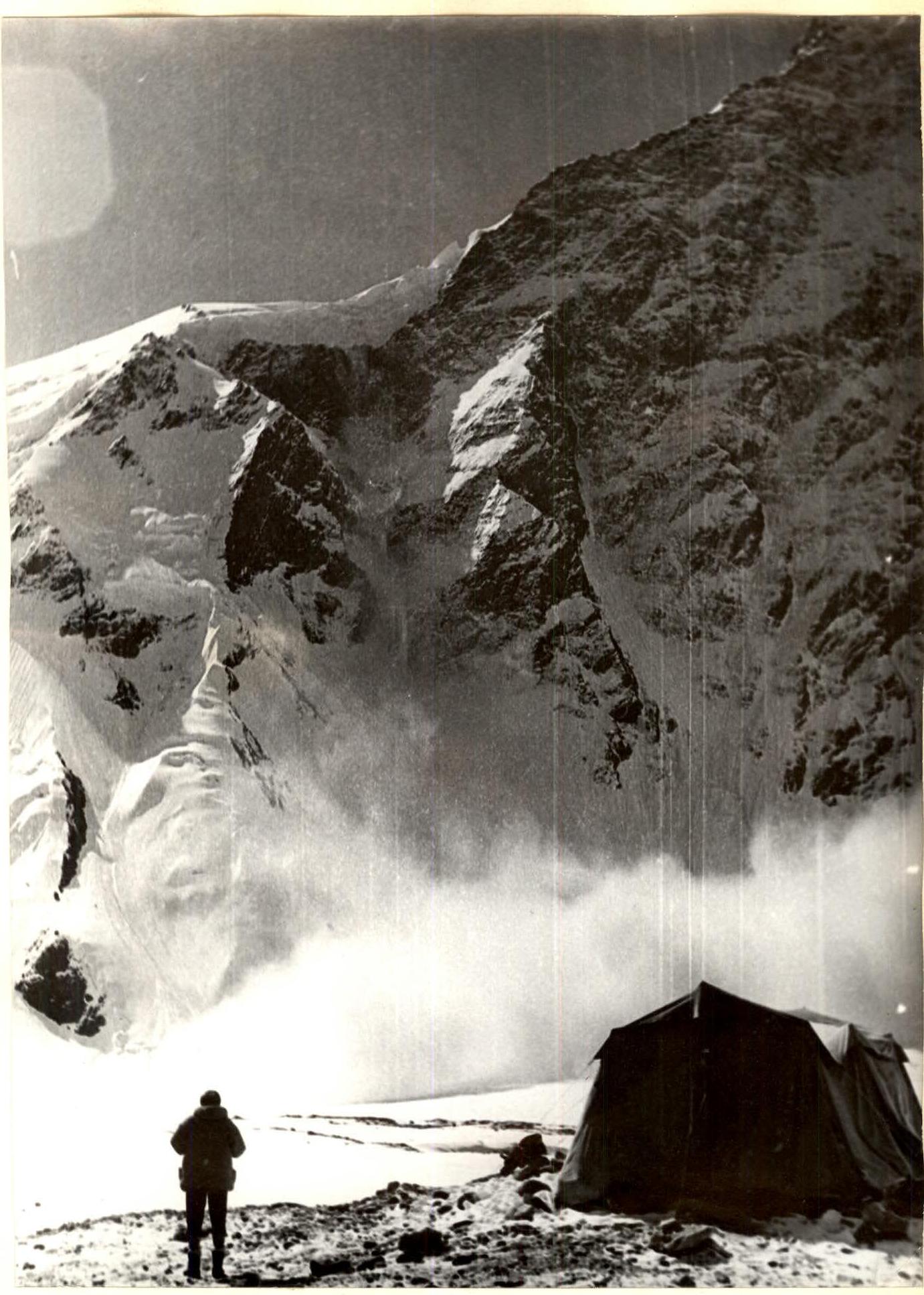
Snow cloud after an avalanche that passed to the right of the route.
Section R2–R3. Along fixed ropes to bivouac №1.

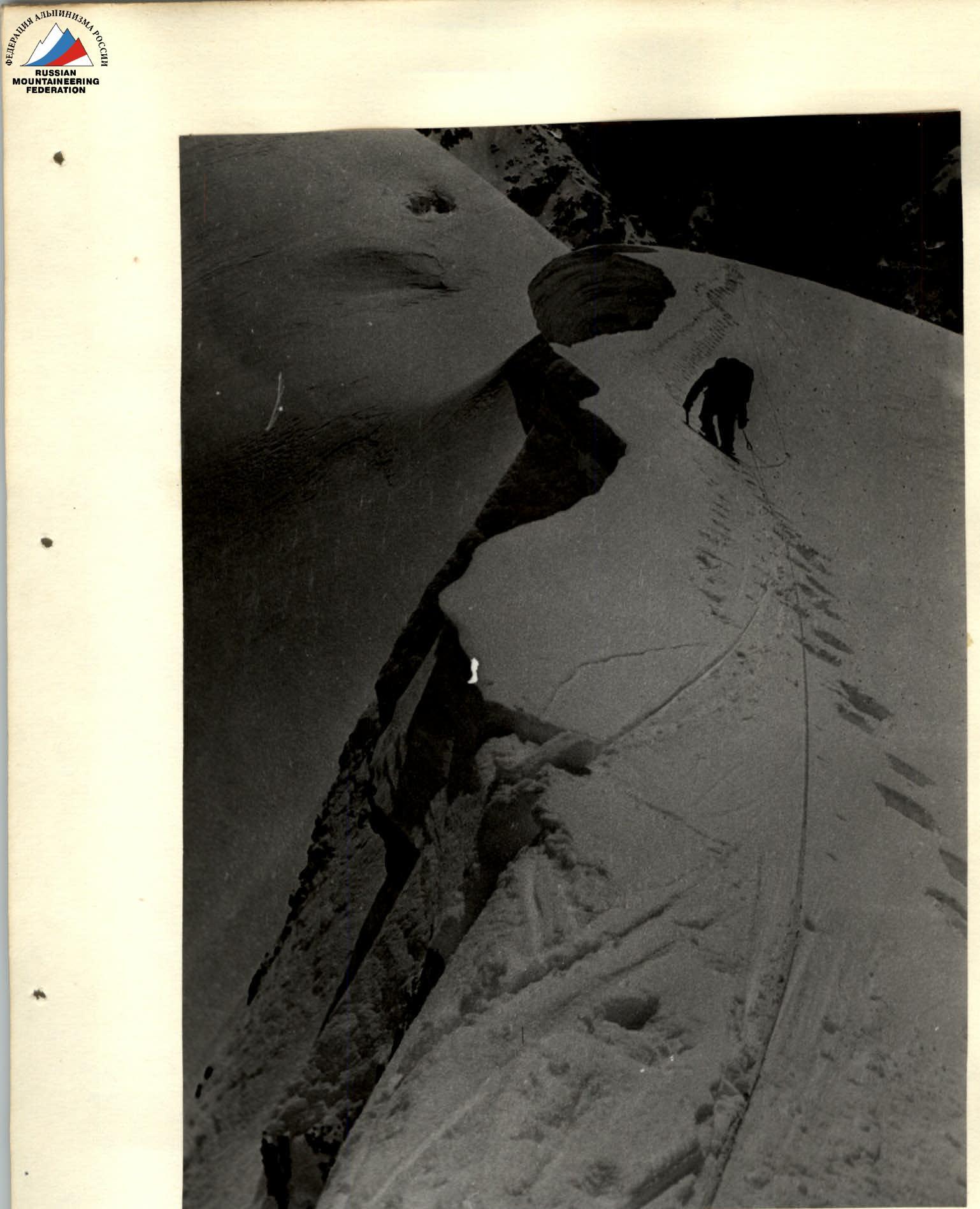
Section R4–R5. Approach to the edge after bivouac №1.
Sections R10–R11 and R11–R12. Mavrin and Benkin exiting onto section R11–R12.
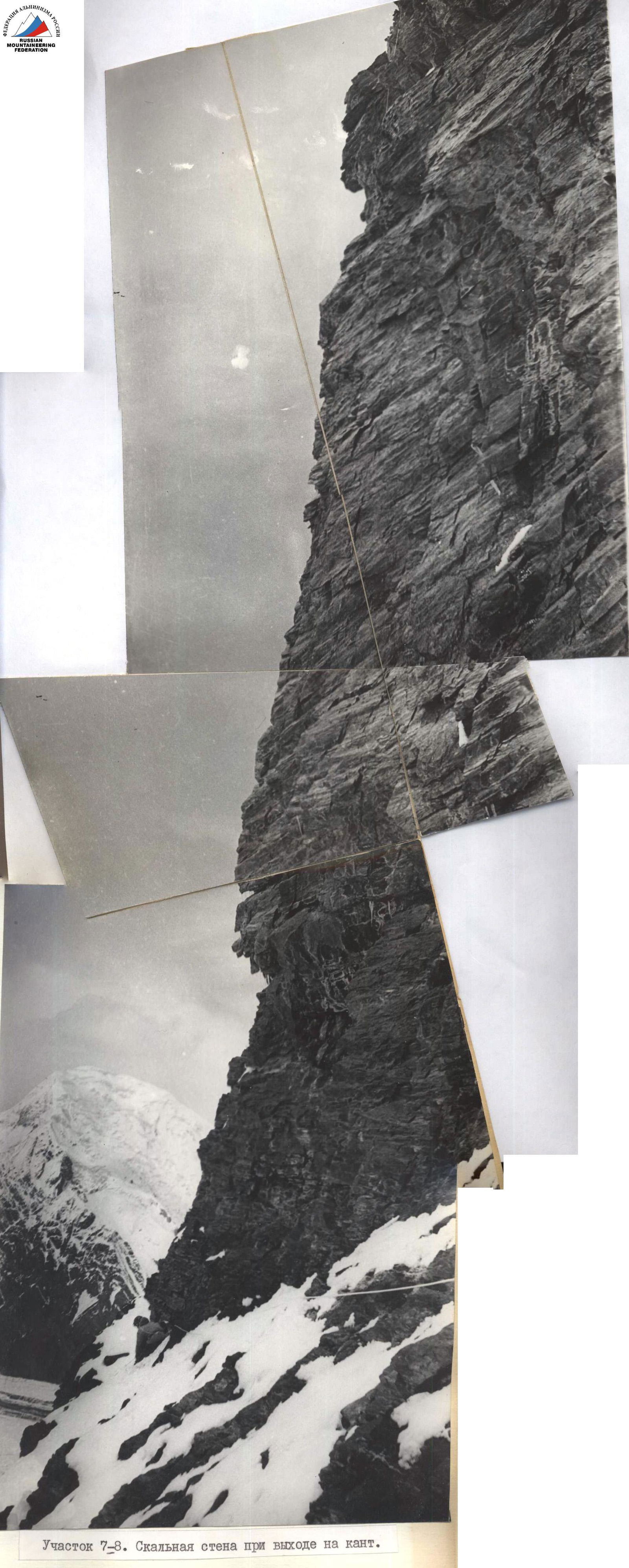
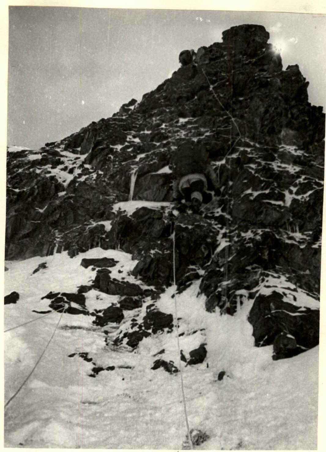
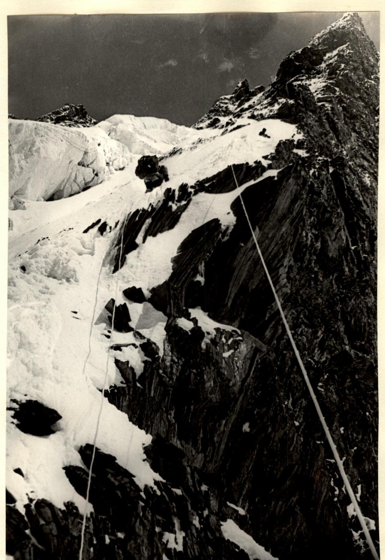
Section R7–R8. Rocky wall upon exiting onto the edge. Ascending the wall to the left of the visible ridge. The upper part of the wall has a visible rope.
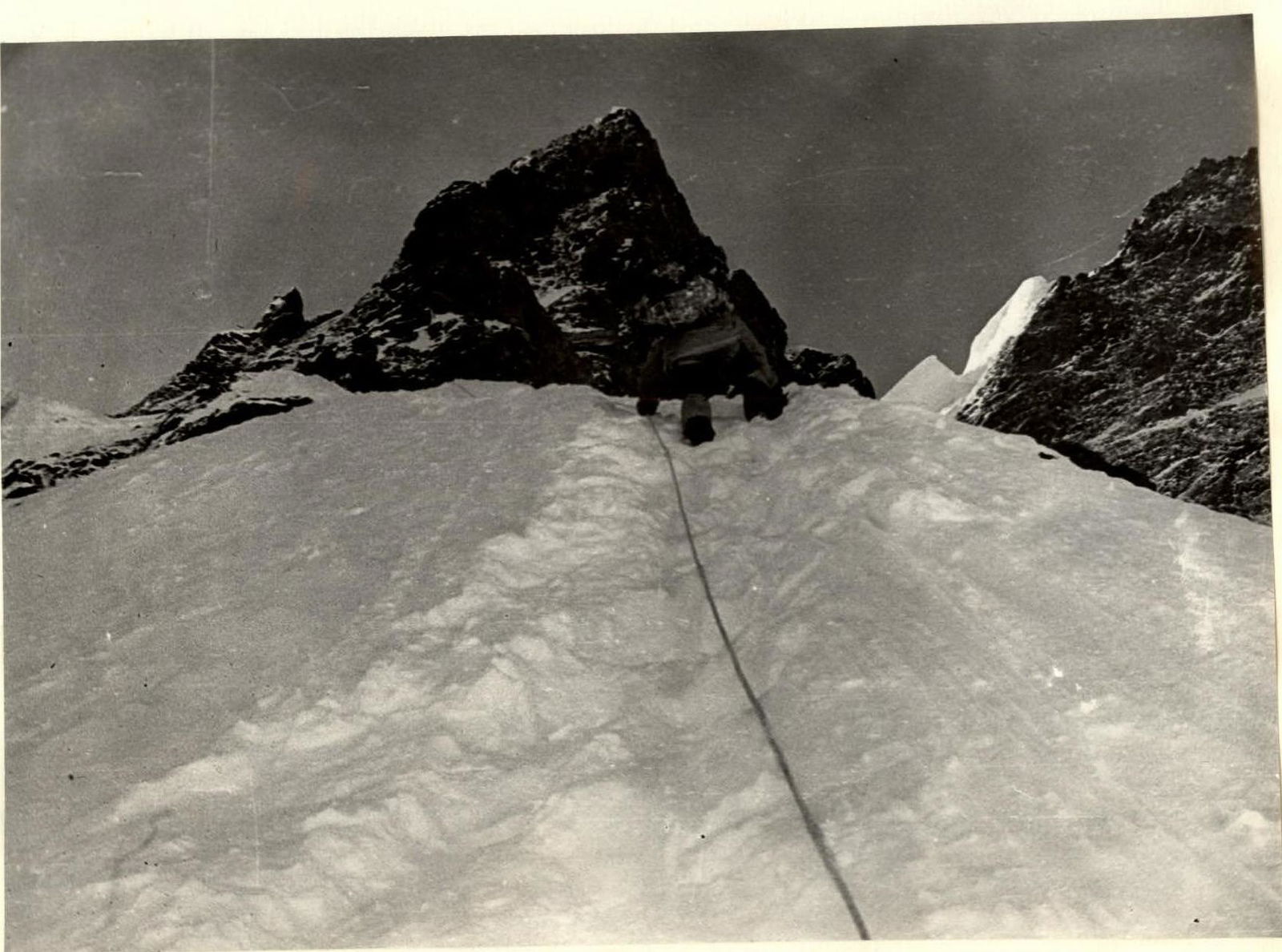
Section R11–R12. Benkin approaching the large gendarme with sections:
- R12–R13
- R13–R14
- R14–R15
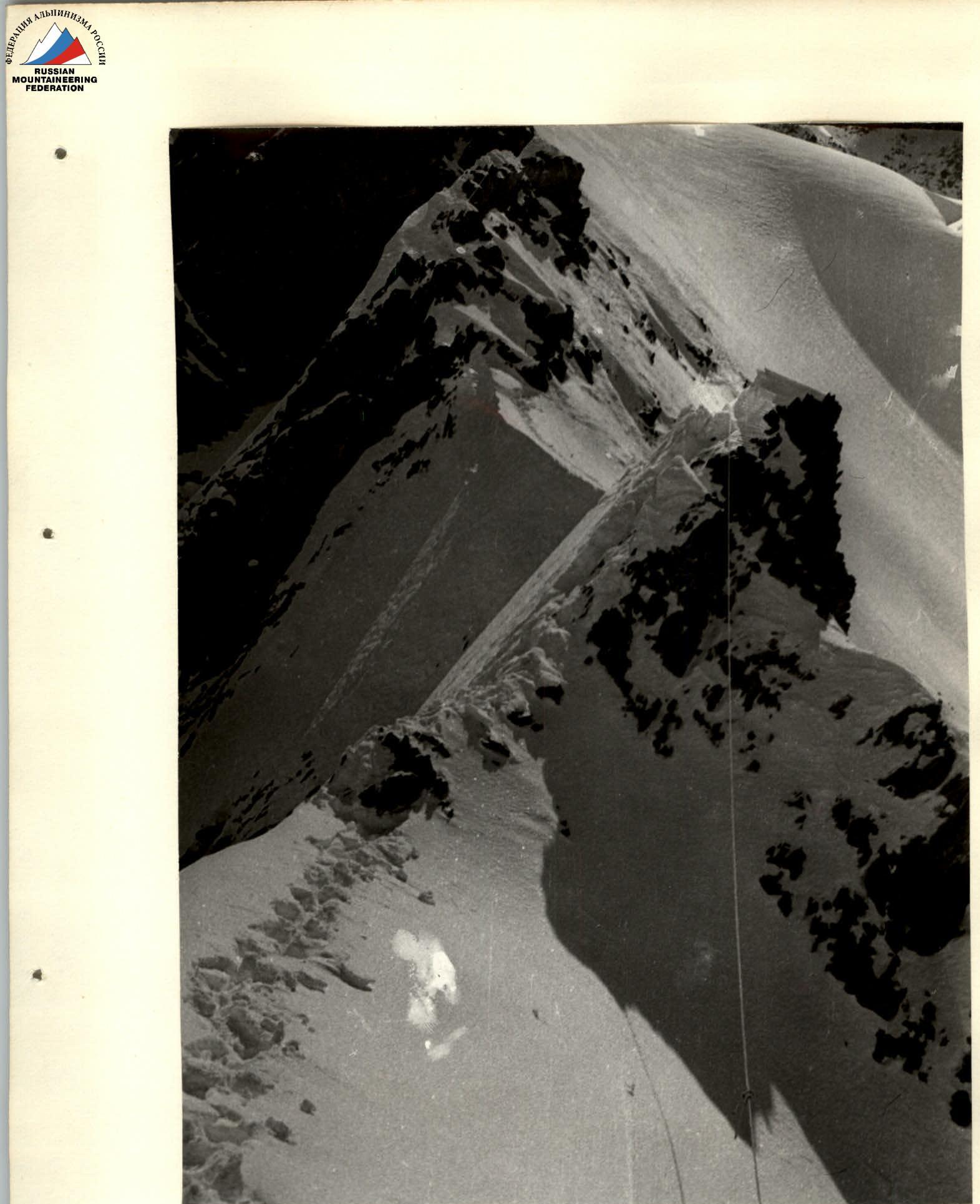
Section R17–R18. Ahead is a corniced ridge.
Section R18–R19. Corniced ridge.
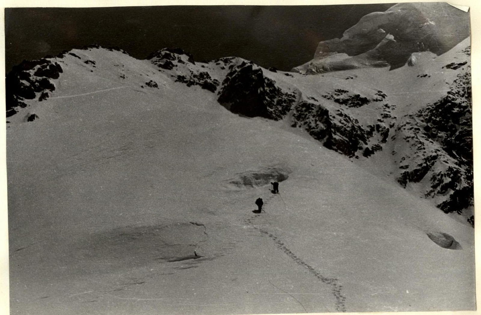
Section R19–R22. Statsky and Mavrin on the icy section.
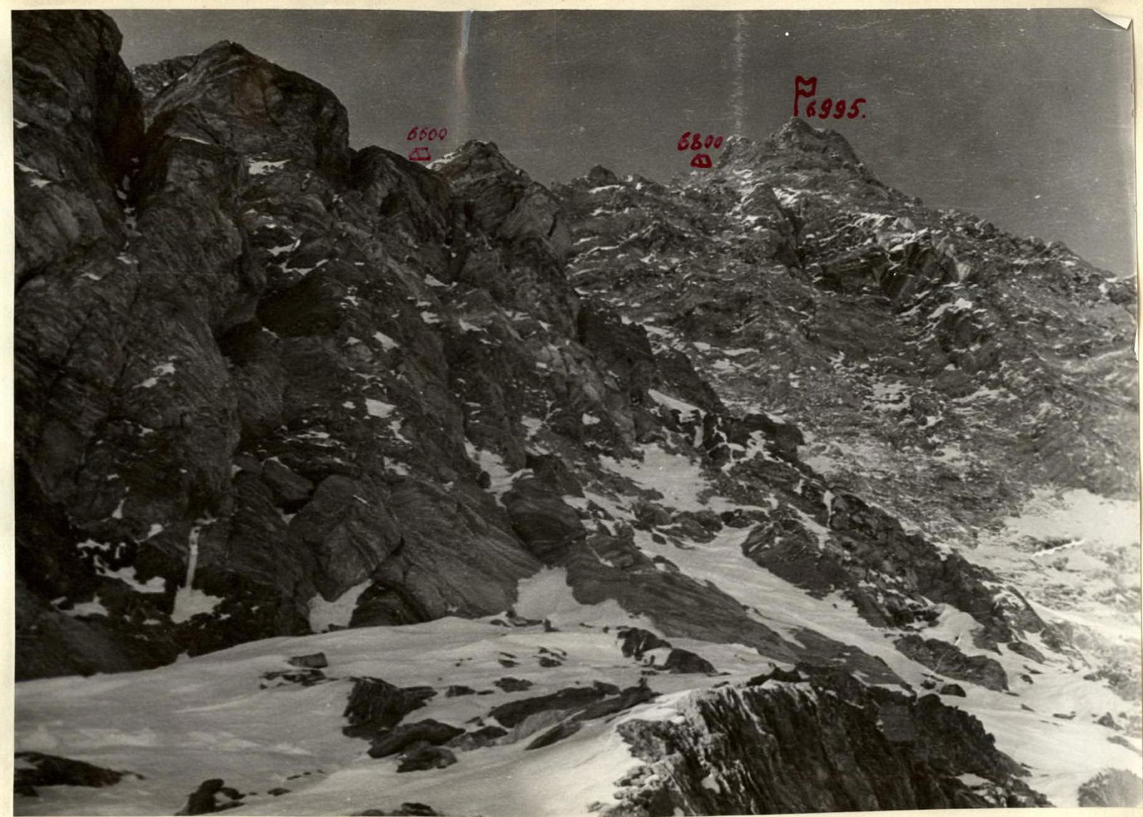
Rocks of the counterfort on section R28–R30. To the right is the slope of the North face.