World Climbing Championship
2012
High-altitude class
Report
on the ascent to Khan-Tengri peak, 6995 m
via the southwestern slope and the left side of the southwestern edge, 5B category of difficulty (variant of the route by E. Kondakov, 1982) by the team from FAiS Ukraine (Ukraine-1), from August 10 to 18, 2009
Team coach: Mityukhin F. P.
Team captain: Venslavovsky D. A.
Vinnitsa — 2012
Addresses:
- Coach Mityukhin Fedor Petrovich
- 40004, Sumy, Metallurgov st., 14/67
- home 8 (0542) 245–606
- work 619–964
Leader Aleksandrovich
- 21009, Vinnitsa, Shirshov st., 3, 104
- phone 0674320309 Steepness was determined visually.
Ascent Passport
- Ascent class — high-altitude.
- Ascent area — Tian-Shan, Tengri-Tag ridge.
- Khan-Tengri peak, 6995 m, via the southwestern slope and the left side of the southwestern edge, 5B category of difficulty (variant of the route by E. Kondakov)
- Route complexity category — 5B.
- Route elevation gain — 2750 m
Route length — 5900 m
Climbing wall part — 600 m
Length of sections: 6th category of difficulty — 0 (including I.T.O. — 0 m) 5th category of difficulty — 210 m (including I.T.O. — 4 m)
| 4th category of difficulty | — 550 m |
|---|---|
| 3rd category of difficulty | — 1150 m |
Average steepness of the route — 30°, Climbing wall part — 50°
- Number of pitons used:
Rock pitons 30 (2), закладных элементов 30 (1), Шлямбурных 0
- Team's walking hours to the summit — 36 hours; 7 days
Descent — 9 hours, 2 days.
- Leader: Venslavovsky Dmitry Alexandrovich, МСМК
Participants: Klebansky Vladimir, МС, Romanenko Dmitry, КМС
- Coach: Mityukhin Fedor Petrovich, МС
- Departure to the route: August 11, 2012, 5:00
summit August 16, 2012, 18:45, descent August 18
EQUIPMENT TABLE
| № | Name | Quantity | Application on sections |
|---|---|---|---|
| 1 | 2 | 3 | 4 |
| 1. | Rope main: D=10.5 mm — 50 m | 1 | |
| 2. | Pitons rock titanium | 4 | |
| 3. | Pitons rock steel | 2 | |
| :--: | :--: | :--: | :--: |
| 4. | Pitons anchor | 3 | |
| 5. | Nuts type «Парус» | 5 | |
| 6. | Cam hooks | 5 | |
| 7. | Hammers rock | 1 | |
| 8. | Quickdraws | 15 | |
| 9. | Belay stations | 5 | |
| 10. | Ice tool | 3 | |
| 11. | Ice axe | 1 | |
| 12. | Shovels avalanche | 2 | |
| 13. | First-aid kit | 1 set | |
| 14. | Route (photo) | 1 | |
| 15. | Personal equipment | 3 sets |
-
Debriefing protocol
-
Photo materials
-
Route sheet
PREPARATION FOR THE ASCENT
The team from Vinnitsa regional FAiS for participation in the Ukrainian Championship in the high-altitude class 2012 included:
- Venslavovsky Dmitry — МСМК, leader
- Klebansky Vladimir — МС
- Romanenko Dmitry — КМС
All participants had:
- good technical and physical preparation
- experience on routes up to 6 category of difficulty inclusive
The object of the ascent — Khan-Tengri peak, with several route variants — was determined before departure to the mountains. A detailed study of route descriptions and a thorough selection of necessary equipment were conducted.
Material support corresponded to the specifics of the chosen route and winter ascent conditions:
-
The team had a full arsenal of pre-checked modern equipment, taken with a necessary reserve.
-
One first-aid kit was taken, assembled by a doctor, which met the necessary requirements. For communication, "Kenwood" radio stations were used. A camera was also taken to collect detailed photo materials.
TACTICAL ACTIONS OF THE TEAM
The team's work plan was calculated for 9 days. It included:
- Ascent to the base camp
- Acclimatization
- Weather condition assessment
- Choosing the ascent route
- Equipment preparation
- Ascent
- Descent
- Return to the starting point
- Completion of the expedition
- Observation of the mountain and weather conditions
- Ascent for the Ukrainian Championship
After carefully studying the routes, realistically assessing the difficulties on the routes and the weather in the area in the current year (a lot of fresh asc snow), the team concluded that it is better to choose the route by Evgeny Kondakov, 1982. The ascent tactics deliberately took into account the possibility of ascending in bad weather.
Observation of the route and final selection of equipment were conducted during acclimatization exit to camp-3 of the classical route (5850 m).
To maintain the optimal speed of passing the route, while maintaining reliability and rational use of strength, the following scheme was implemented work of the rope team:
- On simple snow relief, the entire team moves simultaneously with a change of the leader.
- On complex rock or mixed relief, the first person with a lightened backpack works for a whole day, and on the next day changes. The rest move depending on the relief either on belays or with top rope belay.
- The descent from the summit will follow the classical route.
The weather during the ascent was changeable: from bad — strong wind, blizzard, rocks with wet snow clogged with fresh snow — to normal — weak wind, cloudy. Air temperature — +3°C / −10°C during the day, −10°C / −25°C at night. August 11 — departure at 5:00 from Camp-1 to Camp-2 of the classical route. The main technical difficulty of this section is the icefall with a total height of sheer ice walls of about 60 m. The main objective danger is the unpredictable avalanche from the slope of peak Chapayev, which overlaps 2/3 of the glacier and covers it practically in "asphalt", where there is no chance to survive if caught. It usually comes down in the first half of the day, so it is necessary to pass all the slopes of peak Chapayev by 9:00. August 12 — departure at 8:00. It is necessary to connect — the glacier is closed. Initially, a bit along the classical route, then to the right through the glacier fractures towards the right rock ridge, exiting to the ridge. In its area, the steepness of the snow slope is the least, and accordingly, the avalanche danger is the least. There was very deep fresh snow in places. Especially before exiting to the ridge. It was necessary to dig out rocks to organize belays. The first ones work in turns. After exiting to the ridge, after 100–150 m, we found an arranged bivouac. There was enough time, and we decided to move further. After another 200 m we found a suitable ledge, where a safe camp can be organized. We set up C-3 (6100 m). August 13 — we continue moving along the ridge. We move mainly simultaneously, belaying from rocks. By lunchtime, fog rolled in and a blizzard began. In the fog, we found a place for a safe camp C-4. Height 6550 m. A small snow ridge under hanging rocks. We dug out a site, set up a tent. By night, the snowfall intensified and a strong wind began. All night the snow did not stop, it was necessary to dig out the tent every 1.5–2 hours. August 14 — bad weather continues. We spend the whole day digging out. By evening, it subsides a bit. August 15 — the weather improves. We pack up the camp. We go to search for a safe place to exit directly to the SW edge. (It turned out that in the fog on August 13 we passed by.) We had to descend with a traverse of about two rope lengths. Klebansky works first. Complex snow-clogged rocks. By 12:00 we exit to the ridge. A lot of fresh snow, it is very difficult to work, it is problematic to belay. At 14:00 we understand that we may not make it to the next ledge, we find a place from which we can descend to the previous bivouac. August 16 — we pack up the camp at dawn. We ascend via the fixed ropes. Venslavovsky works first. We move along the right wall of the SW edge. Due to the large amount of snow on the rocks, it is problematic to climb quickly and organize belays. By 16:30 we exit to a snow ledge, leading towards the marble edge (route by E. Kondakov, 1982). We decide to move further along it and not to bivouac. Due to the poor snow condition, we decided not to go straight up via the route by G. Sokolov, 2010. At 18:45 we exit to the summit. At 19:00 we begin the descent via the classical route.
The route was passed safely. Communication sessions were held regularly, without omissions. There were no deviations from the tactical plan. There were no injuries or illnesses among the participants on the route.
Safety measures and accident-free passage of the route included:
- High individual, technical, physical, and psychological preparation of team members.
- Thought-out tactical plan.
- Excellent material support.
The main difficulties during the passage of the route were:
- Icy snow-clogged rocks
- Strong wind
- Fog
Route description by sections
Approach to the route from the base camp along the South Inylchek glacier to Camp-1 of the classical route.
R0–R1. The route coincides with the classical one to Camp-2. Move initially straight up the glacier, then press against the slopes of Khan-Tengri. Then under the icefall cross the glacier to the slopes of Chapayev. 2500 m, category I, 15°–25°.
R1–R2. Up a series of vertical ice walls to exit to the plateau. 60 m, V, 85°–90°.
R2–R3. Along the closed glacier, approach Camp-2. 400 m, category I, 15°–25°.
R3–R4. From the camp, initially along the classical route, then to the right through ice fractures towards the right rocky ridge to the bergschrund. 400 m, II, 20°–40°.
R4–R5. From the bergschrund, move straight up to the base of the rocks. 350 m, III, 40°–60°.
R5–R6. Along the right boundary of rocks and snow, exit to the ridge. Belays are piton, problematic to organize. 200 m, III–IV, 60°. R6–R7. Move left-up along the rocky belt. Good ledge for bivouac. 350 m, II, 25°–40°.
R7–R8. From the bivouac, move straight up to the base of the summit tower. Left and slightly above the base, there is a place for bivouac. 550 m, III–IV, 40°–55°.
R8–R9. From the bivouac, return to the base of the tower. 100 m, III, 40°. R9–R10. Right-up, approach complex climbing under the inner corner. Then along the inner corner exit to the ridge. 50 m, V, 75°–90°
R10–R11. Move up along the right wall of the ridge, sometimes bypassing cornices and vertical walls on the right. 150 m, V, 60°–90°
R11–R12. Continue moving up to a clearly visible oblique snow ledge, going to the "serps". 200 m, III–IV, 45°–60°
R12–R13. Right-up along the snow ledge to the junction with the "serps" route. 200 m, II, 75°–90°
R13–R14. Up initially along not very complex rocks, then along snow couloirs exit to the summit dome. 150 m, III, 35°–50° R14–R15. Up along the summit dome to the summit. 250 m, II, 20°
Brief overview of the area
In our post-Soviet space, there is an amazing mountain range, not inferior in height, complexity, and beauty to the most famous mountain ranges in the world.
Just two stunningly beautiful peaks attract hundreds of climbers from different countries every year. And if peak Pobeda (7439 m) has no routes for beginning high-altitude climbers, then peak Khan-Tengri (6995 m, or maybe 7010 m) offers a relatively simple and logical route, suitable for all climbers.
True, the classic route on Khan-Tengri:
- is equipped with fixed ropes;
- is interesting only for novices who have been to the area for the first time;
- is suitable for acclimatization before Pobeda.
Other routes on Khan-Tengri are climbed only by sufficiently experienced high-altitude climbers due to:
- high objective danger
- technical complexity of the relief at high altitudes.
| № Уж.ка | схема в символах УИАА | протяж. м. | крутизна гр. | кат. сл. | Количество точек |
|---|---|---|---|---|---|
| R9 | 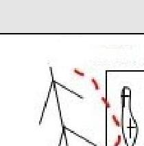 | 300 | 45-60 | IV–V | 24 |
| R2 | 400 | 15-25 | I | - | |
| :--: | :--: | :--: | :--: | :--: | :--: |
| R1 | 60 | 85-90 | V | - | |
| 2500 | 15-25 | I | - | ||
| 入 29.68 | схема в символах УИАА | протяж., м. | крутизна гр. | кат. сл. | Количество точек |
| --- | --- | --- | --- | --- | --- |
| R15 | 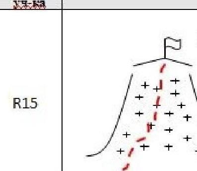 | 250 | 20 | II | |
| R14 | 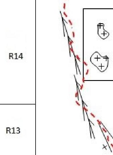 | 300 | 40-45 | IV | 20 |
| R13 | 50 | 40-60 | IV–V | 4 | |
| R12 | 200 | 75-90 | II | - | |
| --- | --- | --- | --- | --- | --- |
| R11 | 150 | 60-90 | V | - | |
| R10 | 50 | 75-90 | V | - |