PASSPORT
-
High-altitude class.
-
Central Tian-Shan, South Inylchek glacier.
-
Peak Khan-Tengri via the South-Southwest ridge.
-
5B category of difficulty, previous ascent was over 3 years ago.
-
Elevation gain — 2610 m, route length — 2840 m.
Length of sections with 5–6 category of difficulty — 2010 m. Average steepness of the main part of the route — 47°, including 45 m of 6 category of difficulty with 70° steepness.
-
Hooks left on the route (not removed) — none.
Previously driven hooks used and not removed — none.
-
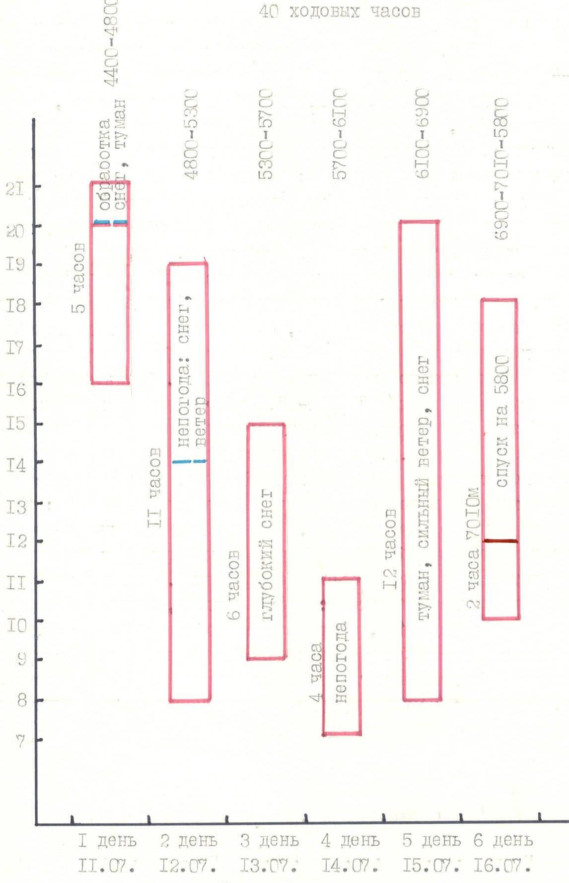
Team's climbing hours: 40 and days – 6.
-
Overnight stays: 1–2 — semi-reclined on the slope, 3–4 — good on snow, 5 — semi-reclined on a rocky slope.
-
Leader: Sergey Konstantinovitch Penzov, Master of Sports of the USSR
Team members:
- Viktor Vasilievich Zhuravlev, Master of Sports of the USSR
- Igor Vladimirovich Benkin, Master of Sports of the USSR
- Vladimir Alexandrovich Nefediev, Candidate Master of Sports
- Andrey Evgenievich Volkov, Candidate Master of Sports
- Vladimir Alexeevich Zhestkov, Candidate Master of Sports
- Vladimir Georgievich Zakharov, Candidate Master of Sports
-
Coach: Sergey Petrovich Galkin, highest category coach, Master of Sports of the USSR
-
Departure to the route: July 11, 1990.
Summit — July 16, 1990.
Return — July 17, 1990.
-
Organization: Kuibyshev Alpine Club "Vertical"
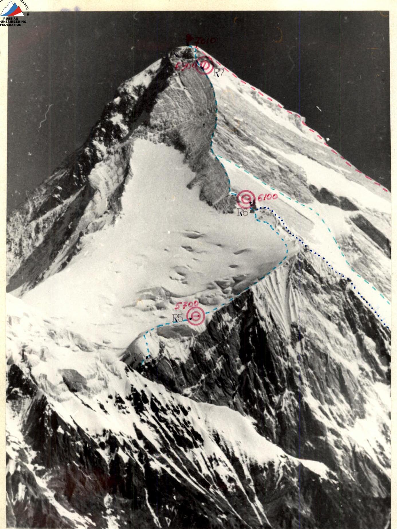
Photo 1. General photo of the route.
- — route taken by the team from a/k "Vertical" in 1990;
- — Sviridenko's route, 1982;
- — Isaichenko's route, 1982;
- — Voronin’s route, 1973.
Photo taken from a helicopter on July 11, 1990 at 11:00. Lens "Industar-22", focal length 50 mm, shooting height 6000 m, distance to the route 2 km, shooting point #1.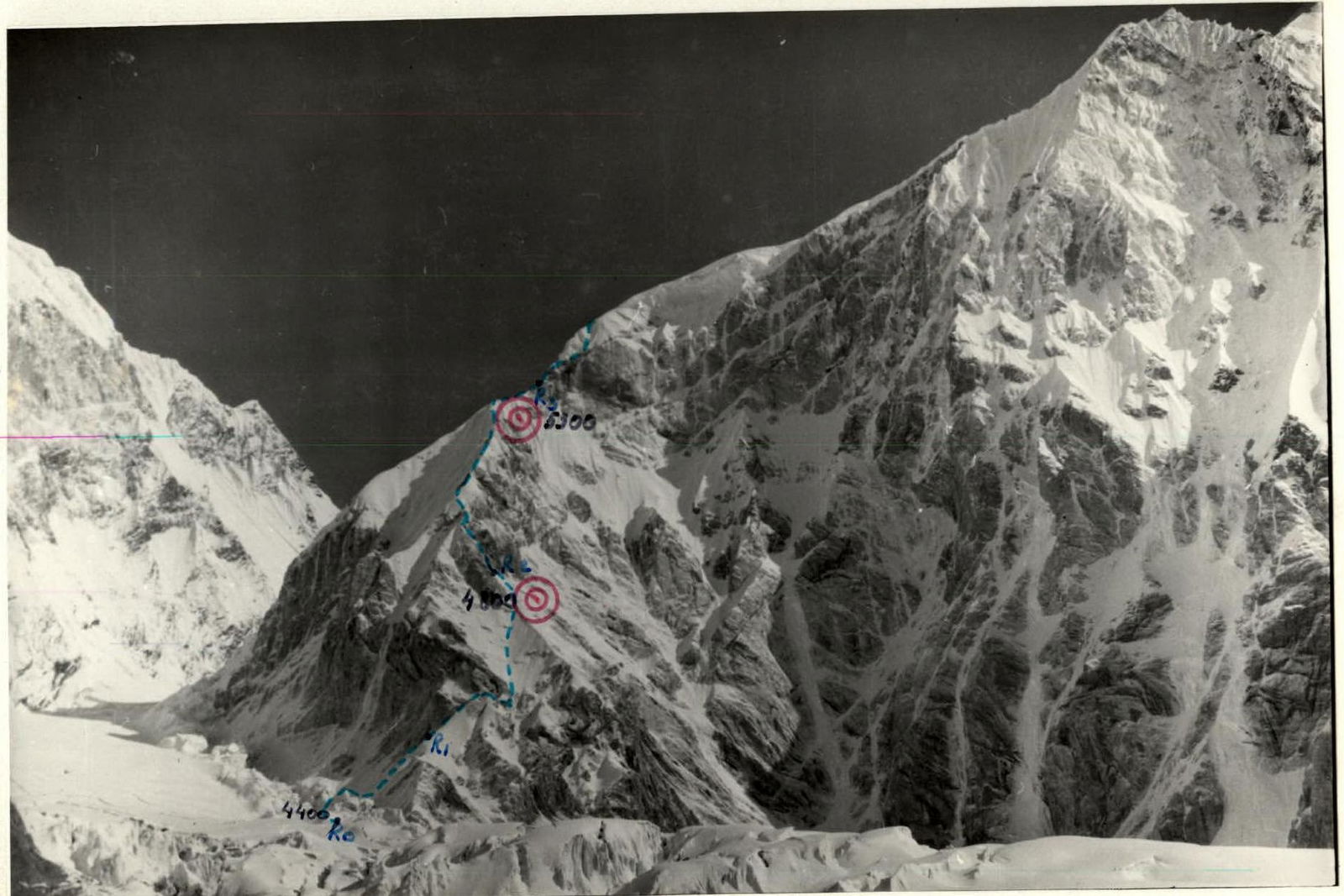
Photo 2. Profile of the route from the right, bottom. — team's route. Taken on July 15, 1990 at 14:00. Lens "Industar-22", focal length 50 mm, shooting height 4200 m, distance to the route 1500 m, shooting point #3.
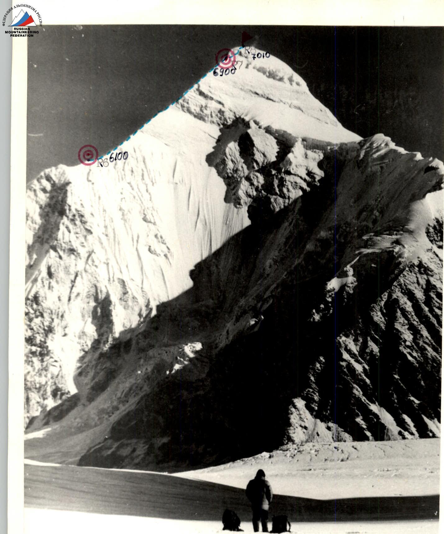
Photo 3. Profile of the wall from the right, top. — team's route. Taken on July 27, 1990.
- — Lens "Industar-22", focal length 50 mm
- — Shooting height 4400 m
- — Distance to the route 6000 m
- — Shooting point #2
Team's Tactical Actions
On July 11, 1990, at 6:00, the team set out in full to approach the Romanov route. Before departure, there was a prolonged bad weather, and the team, after resting and reviewing the route again, decided to take advantage of the good weather, covering 8 ropes of snow and rocks on the route. The overnight stay was organized on a steep rocky slope. Sections R0–R2 were completed.
On July 12, 1990, at 8:00, the first rope team started working on the route on the right side of the snow-covered rocks. Cold and snowy conditions on the rocks required utmost attention and concentration. Unstable weather affected the movement. Further work on a very difficult and dangerous ridge with double-sided cornices continued until the end of the day. Platforms for two high-altitude tents were carved out on a sharp firn ridge. Section R2–R3 was completed.
On July 13, 1990, there was a lot of snow. The first rope team departed at 9:00. Movement was through steep snow-covered rocks with piton protection, and the team reached the hanging glacier. Overcoming it took a lot of effort and time; ice screws and rope hauling were used. Upon reaching the hanging glacier and getting into slushy snow, the team decided not to tempt fate and organized a bivouac. Sections R3–R5 were completed.
On July 14, 1990, the weather deteriorated in the morning. Departure on the route was at 7:00, and through deep snow, the team reached under the marble ridge. Visibility was lost, it was snowing, and the team stopped for a day's rest. Section R5–R6 was completed.
On July 15, 1990, there was fog and snowfall in the morning. Departure on the route was at 7:00. Working on the snow-covered marble ridge required great caution. In some places, the first climber's movement was on friction, and fragile snow-covered rocks in strong wind and frost were traversed very tensely. Section R6–R7 was completed. The overnight stay was organized on a rocky slope under the summit tower.
On July 16, 1990, it was very cold. Departure on the route was at 10:00. After passing the summit tower and snow dome, the team was on the summit of Khan-Tengri at 12:00!
The descent from the summit was well-known to all, and within 6 hours, the team descended to the saddle.
On July 17, 1990, at 11:00, the team, along with observers, was back in the base camp. The entire ascent took 40 climbing hours instead of the planned 33. The deviation from the tactical plan was due to:
- very heavy and deep snow cover;
- a large number of snow cornices on the ridge;
- high complexity of snow-covered rocks;
- bad weather and strong wind.
During the ascent, the team's nutrition regime was as follows:
- in the morning — sandwiches with tea and juice;
- during work — potato-based nutrition;
- at the bivouac — plenty of drinks and a hearty dinner.
Food supplies were sufficient until returning to the base camp. The medical kit was not used during the ascent. There were no falls, injuries, or frostbites. Throughout the route, there were no missed radio communications. Communication with observers and the base was carried out using the "Karat" radio station. The first climber's movement on the route was on an approved rope. On complex and dangerous sections, the team used fixed ropes for the participants. For traversing snow, "combines" — combined ice axes with snow anchors — were used. All team members demonstrated high physical and technical fitness and emerged victorious from this challenge. A rescue team of 6 Candidate Masters of Sports was in close proximity to the team: on the Semenovsky glacier and on the saddle. This ascent was the first on Khan-Tengri that year.
Photo numbers that reflect the described moments:
- Photo #5. Team's work on section R2–R3;
- Photo #6. Work at the beginning of section R3–R4;
- Photo #7. Exit to the hanging glacier on section R3–R4;
- Photo #8. Bivouac on the hanging glacier;
- Photo #9. Team working on the marble ridge, section R6–R7;
- Photo #10. Team on the summit of Khan-Tengri.
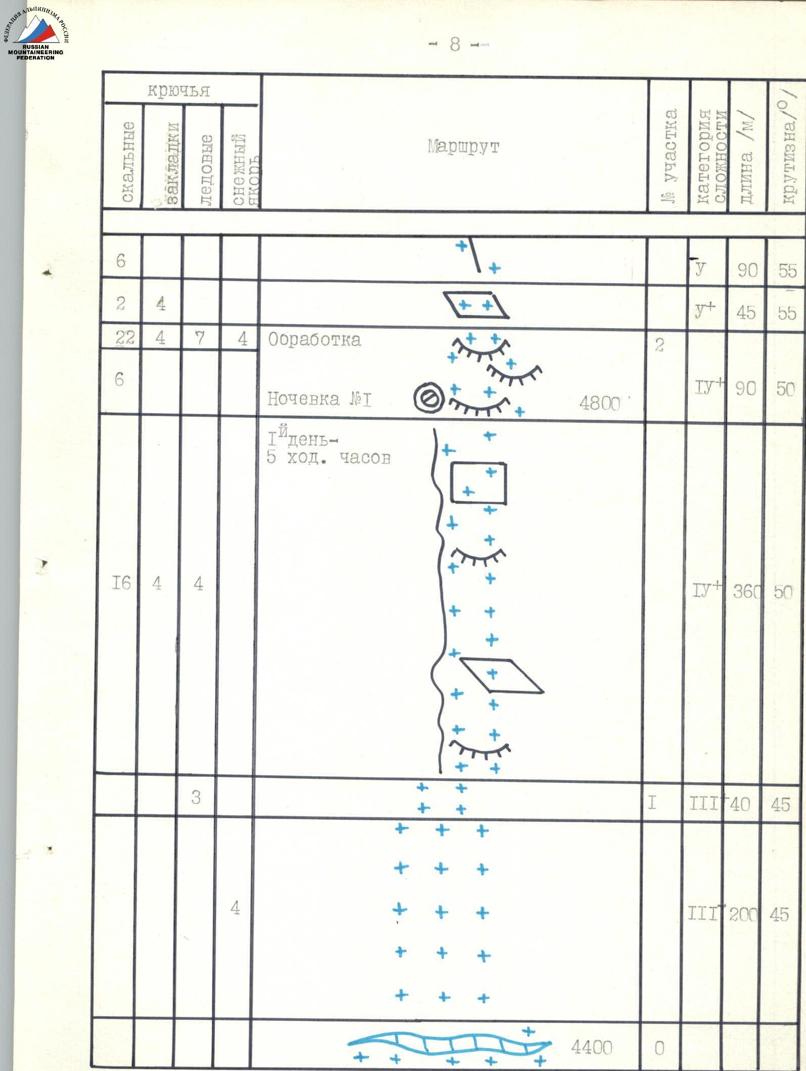
Route scheme in UIAA symbols. Scale 1:4000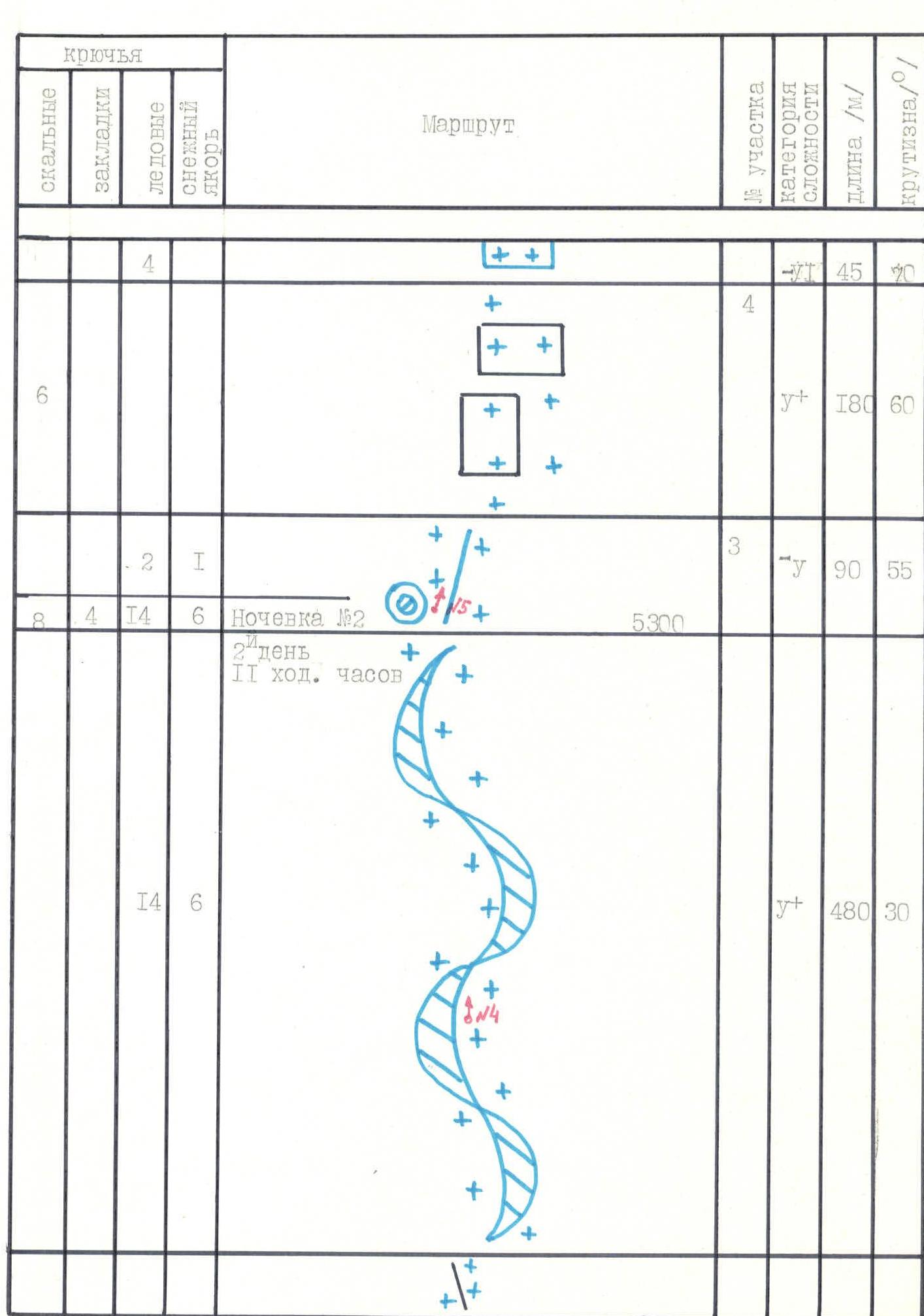
Route scheme in UIAA symbols. Scale 1:4000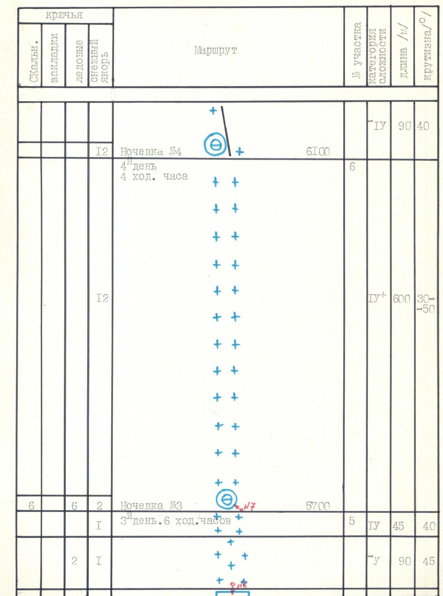
Route scheme in UIAA symbols. Scale 1:4000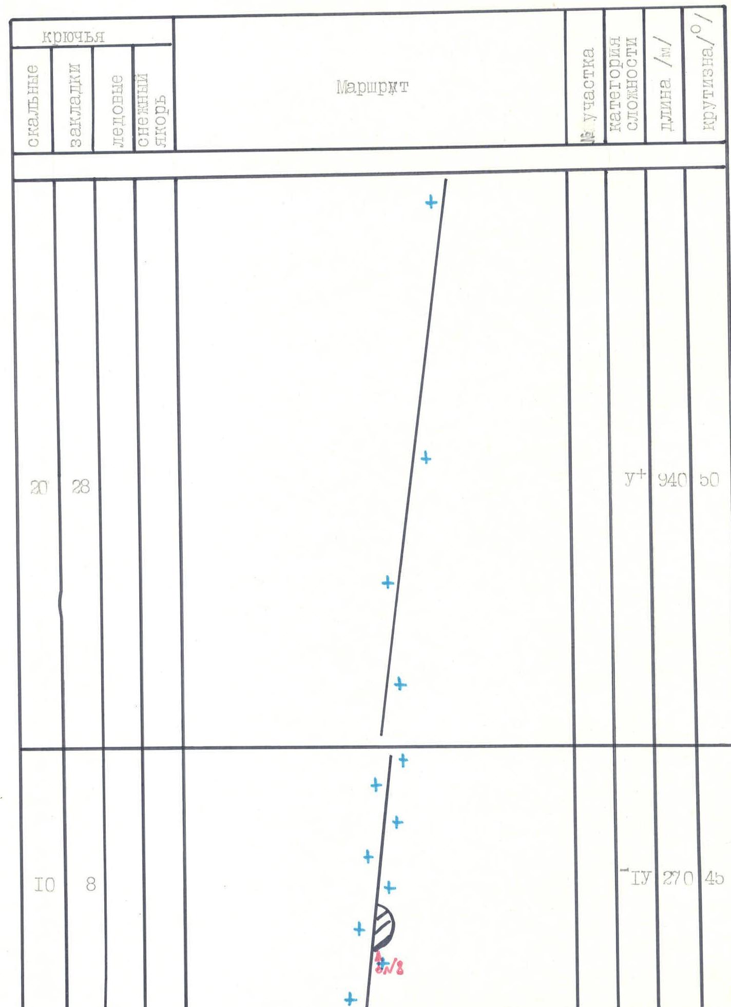
Route scheme in UIAA symbols. Scale 1:4000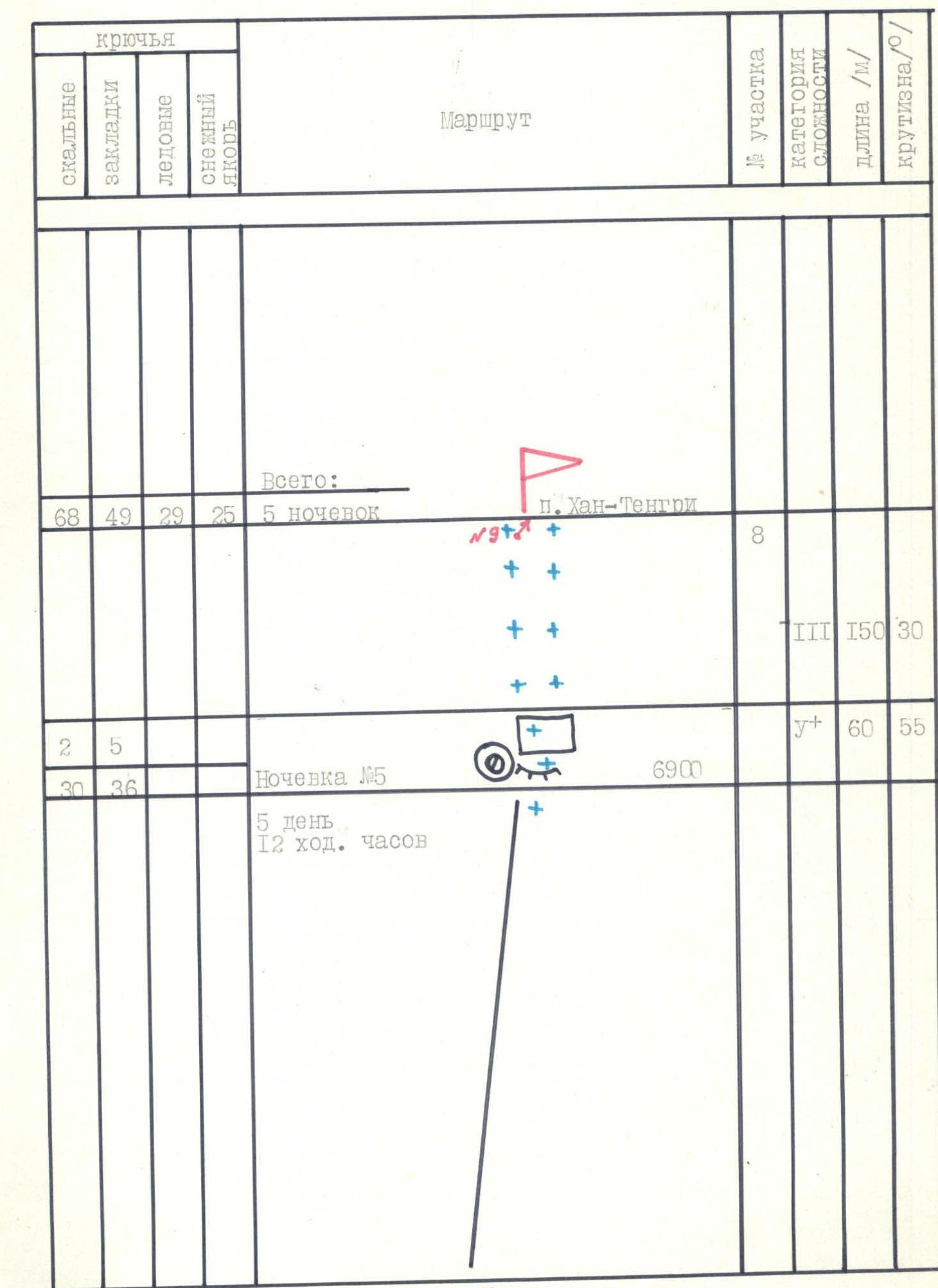
Route scheme in UIAA symbols. Scale 1:4000
Description of the Route by Sections
Day 1. July 11, 1990. Section R0–R1. Overcoming the glacier and simultaneous movement along a snow-ice slope. The first to work were Zakharov V. and Benkin I. The last rope was on ice with the use of fixed ropes, ice screws, and snow shovels.
Section R1–R2. Alternating movement with the use of fixed ropes on steep snow-covered rocks on the right side of the ridge with the use of rock pitons and chocks.
Day 2. July 12, 1990. Section R2–R3. Alternating movement with the use of fixed ropes on steep snow-covered rocks with piton protection and further along a long snow ridge with cornices and organization of protection on snow anchors. Very dangerous. It is possible to go with a cornice or avalanche on the right side of the ridge. Deep snow and double-sided cornices sharply limit the speed of passage.
Day 3. July 13, 1990. Section R3–R4. Alternating movement on steep snow-covered rocks with the use of fixed ropes and protection through pitons and ledges, exiting under the hanging glacier on the right.
Section R4–R5. Very complex exit to the hanging glacier with hauling backpacks with protection through ice screws and snow anchors in the upper part.
Day 4. July 14, 1990. Section R5–R6. Simultaneous and alternating movement on the hanging glacier. Very deep snow. The steepness of the slope changes significantly. Protection through snow anchors.
Day 5. July 15, 1990. Section R6–R7. The beginning is gentle, then a long, steep part of the snow-covered ridge. In some places, movement is on friction, with a limited number of holds. The rocks resemble those in Crimea, but are very fragile. Movement is alternating with the use of fixed ropes. Cold, strong wind tries to sweep the team off the ridge.
Day 6. July 16, 1990. Section R7–R8. Rocky-snow "roof". Initially, steep snow-covered rocks with piton protection lead to the snow dome, and from there, it's not far to the summit of Khan-Tengri. Movement on the dome is simultaneous. Descent to the saddle in a cave took 6 hours.

Photo 4. Technical photo.
- — Team's route
- — Photo taken on July 14 at 13:00
- — Lens "Industar-22", focal length 50 mm
- — Shooting height 4200 m, distance 1500 m, shooting point #3
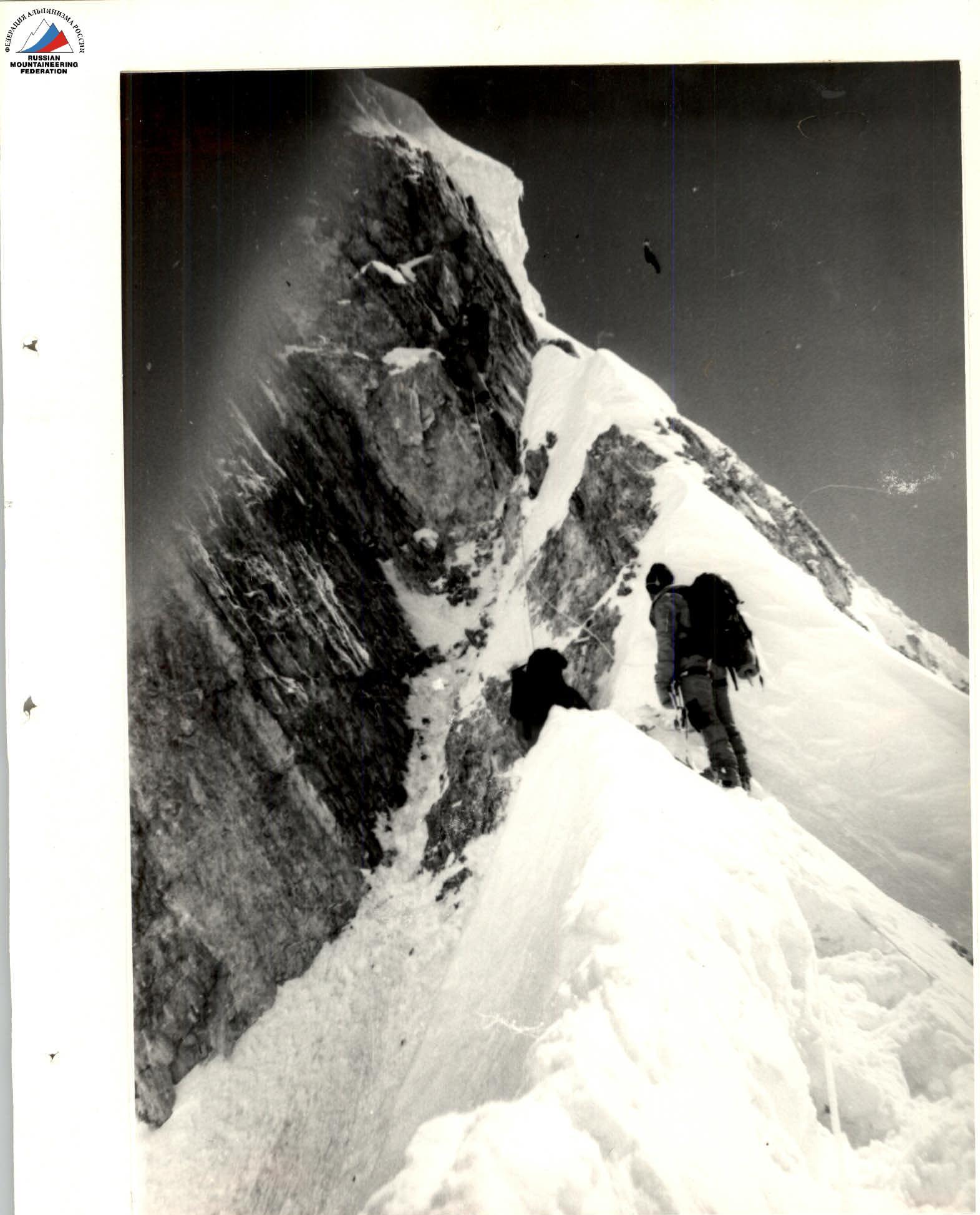
Photo 6. Taken from bivouac #2, section #3. Taken on July 13 at 10:00. Camera "Smena", shooting point #5.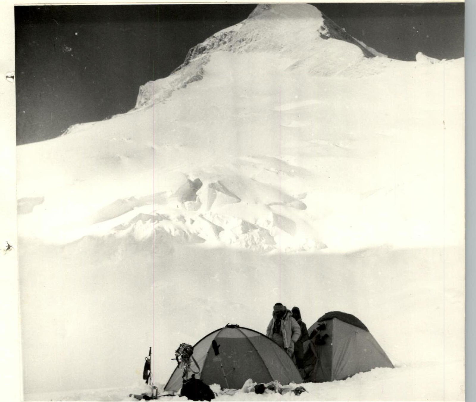
Photo 8. Bivouac on section 5. Taken on July 13 at 17:00 with a "Smena" camera. Shooting point #7.
Preparation for the Ascent
Preparation for this ascent began long before departing for the route: in the summer of 1989, team members climbed Peak Khan-Tengri via the Pogrebetsky route, and at that time, they carefully examined the Romanov route. It was appealing due to its logic, the beauty of the marble ridge, high technical complexity, and relative safety.
By the time of departure for the route, prolonged bad weather significantly complicated the route's condition:
- Deep snow lay in the lower part of the route.
- Passing the ridge with cornices became a problem.
- The marble ridge was covered with a continuous blanket of snow, reducing traversability and reliability of protection.
To ensure reliable protection on snow, "combines" with avalanche shovels were used. The first climber's movement was planned on an approved rope. To ensure safety of movement on the route in very poor weather conditions was not planned.
The team was fully equipped for this high-altitude ascent. Communication with observers was carried out using the "Karat-M" radio station. Simultaneously, communication with the base was maintained. All route documentation was reviewed by judge Izmailov V. N. on site. Observation of the team on the route by the coach was planned using 12x binoculars.
A rescue team consisting of 6 Candidate Masters of Sports was in close proximity to the team: on the Semenovsky glacier and on the 5800 m saddle. After the team descended to the saddle, the rescue team returned to the base camp. Emergency evacuation by helicopter to Przhevalsk for the injured was planned.
When departing on the route, the following factors were taken into account:
- bad weather;
- abundance of snow and snow cornices on the route;
- snow-covered and icy rocks.
As a result, departure on the route was planned for early hours with early organization of a bivouac in two high-altitude tents on safe platforms. Before departing on the route, team members passed physical fitness tests with "good" and "excellent" marks.
Ascent Schedule
40 climbing hours