Ascent Passport
-
Ascent class — high-altitude technical
-
Region — Tian-Shan, Tengri Tag ridge, route № 7.9.8
-
Peak — Khan-Tengri, via the Southwest ridge
-
Category of difficulty — 5A
-
Route type — combined
-
Route elevation gain — 2800 m.
Route length — 5290 m. Length of sections with category difficulty — 1040 m. Average slope: — main part — 45° — entire route — 35°
-
Number of travel hours — 18 hours. Days — 2.
-
Overnight stays — 1, in a snow cave.
-
Team composition:
Arkhipov Vladimir Alekseevich MS, team leader Glazyrin Yuri Evgenievich CMS Khvostenko Oleg Valerievich CMS
-
Team coaches:
Zakharov Nikolai Nikolaevich IMS Balezin Valery Viktorovich IMS
-
Departure dates:
— on the route — at 4 am on August 16, 2000 — on the summit — at 4 pm on August 18, 2000 — return — at 8 am on August 19, 2000
-
Organization: Krasnoyarsk Kraysportkomitet
General view of Khan-Tengri peak 6995 m.
Tactical Actions
For better acclimatization and cost savings, it was decided to move on foot from the MACA "Khan-Tengri" (Maidaydyr gorge, 552 km from Bishkek, 2500 m above sea level) to the base camp under Peak Gorky (4000 m).
- On August 3, 2000, we departed from the overnight stay in Maaydadyr. It's possible to drive a car for about 20 km to Jailyo Camp (Gribkov A.S., Streltsova T.I. farm). The road is toll, we walk.
- Tatyana Ilyinichna Streltsova welcomes us very warmly, we stay for about 2 hours. She invites us to stop by on the return journey.
- On August 6 at 17:30 we arrived at the base camp (4000 m).
- On August 8, we went on an acclimatization trip with the plan to spend the night in the intermediate camp at Shubinsky overnight stays (4200 m) — the confluence of the Semenovsky glacier and the South Inylchek glacier. The journey from the base to the intermediate camp takes about 2 hours.
- On August 9, we departed at 4 am from the intermediate camp (section R0–R1). The section R0–R2 should be traversed from 4 to 8 am due to possible avalanches and icefalls. At 5300 m (section R2–R3), we set up a high-altitude tent, had a snack, and continued upwards. From 5300 to 5900 m (section R3–R4) — 1.5–3 hours of travel depending on the conditions. By 12 pm, we approached the caves (section R3–R4, 5900 m). There are representatives from Kazakhstan, Vladivostok, Spain, Israel, Italy, and Germany — quite crowded. We dug a comfortable cave and settled in for the night. It was planned to descend to the base camp the next day after the overnight stay. However, it snowed at night. By morning, the layer of snow was quite deep, visibility 2–3 meters, and the snowfall didn't stop. We decided to stay put for the day.
- August 10 — a day of rest and "improving acclimatization" — going out was dangerous.
- On August 11, we departed from the caves at 5 am. The layer of fresh snow was 60–70 cm. By 1 pm, we descended to the base camp (4000 m). All tents were knocked down (except one).
- August 12 — a well-deserved rest day.
- August 13 — attempting to approach the intermediate camp was unsuccessful — it was raining with snow. We stayed put.
- August 14 — staying put, rain and snow.
- August 15 — snow and rain with intervals. At 4 pm, we departed for the intermediate camp (4200 m).
- On August 16, we departed at 4 am from 4200 m. Wind, snow — tracks were immediately covered. At 5300 m, the high-altitude tent was snowed over but still standing. We had tea and continued. By 11 am, we approached the cave (5900 m). We rested and considered options for the next day. Representatives from Moscow strongly recommended starting the descent from the summit no later than 4 pm.
- On August 17, we rose at 3 am. The weather was bad — snow, visibility 4–5 meters. We decided to stay put.
- On August 18, we rose at 3 am — today the weather was a bit better, but still snowy and foggy. We decided to proceed with the route. We departed at 4 am. Visibility up to 50 meters. We moved simultaneously, all in crampons, with ice axe belay, through outcrops. We encountered both new and old fixed ropes. The icy couloir (section 8–9) was covered in snow, and we traversed it fairly easily. The walls of section 10–11 were steep but had a rich relief (photo from section 10–11). On section 11–12, the snowy ridge was very narrow at the top. According to some climbers' recommendations, it should be traversed sitting astride. The wind was very strong. Khvostenko reached the summit at 3:30 pm, and by 4 pm, we all gathered. There was no control note. We took photos. It was very cold. We began descending via the ascent route and as quickly as possible. By 7 pm, we were already in the cave. Tomorrow, we would head to the base camp.
For radio communication, we used ALINCO radio stations in the 144 MHz range. Radio communication was stable.
Description by Sections
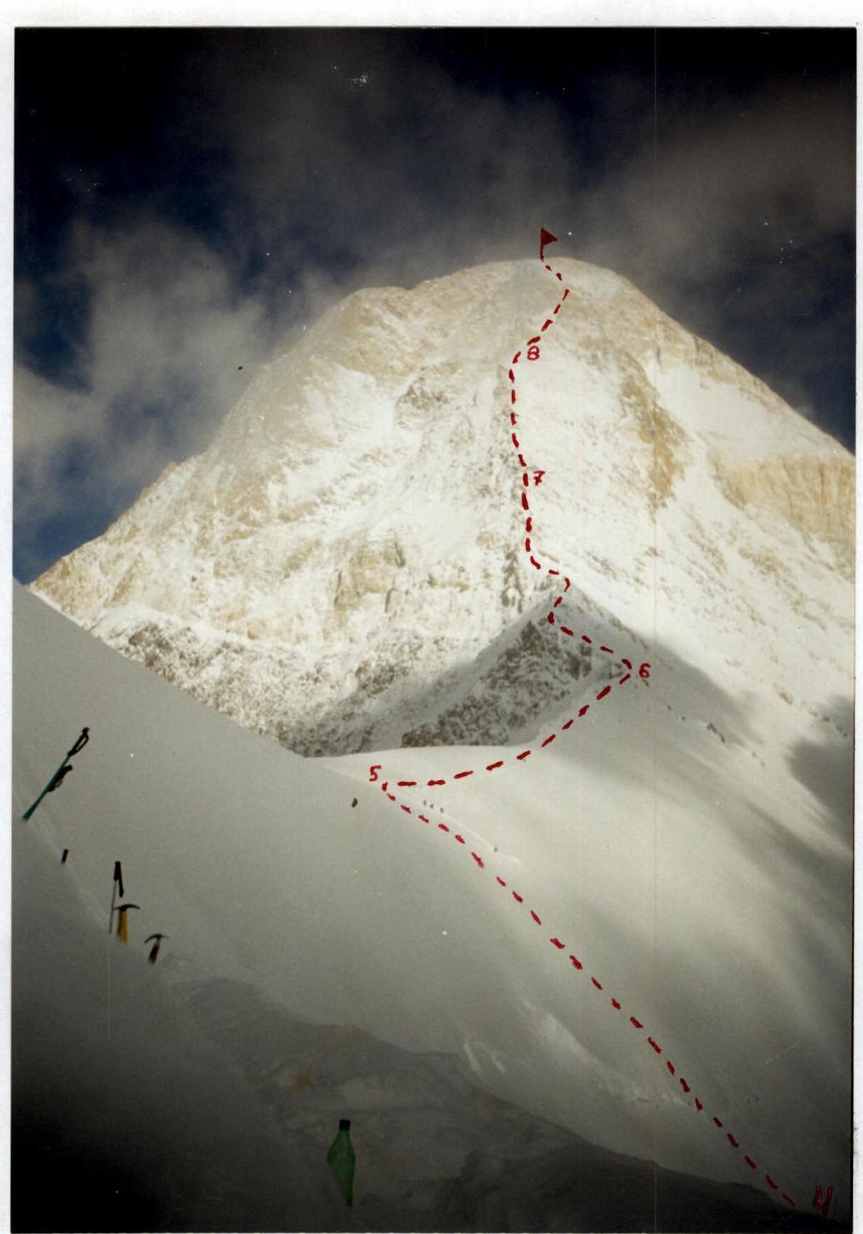
Section № R0–R1. Closed glacier. Section № R1–R2. Icefalls. Section № R2–R3. Snow slope. Section № R3–R4. Icy slope. Caves. Section № R4–R5. Icy slope. Section № R5–R6. Snow ridge. Section № R6–R7. Snow-covered rocky ridge. Section № R7–R8. Snow-covered rocks, walls like "ram's foreheads". Section № R8–R9. Ice and snow couloir, from left to right. Section № R9–R10. Snow-covered rocky ridge, snow cornices. Section № R10–R11. Steep walls. From here, it's 1.5–2 hours to the summit. Section № R11–R12. Snow ridge, very narrow at the top. Section № R12–R13. Snow-covered rocks leading to the summit — a triangulation tripod.