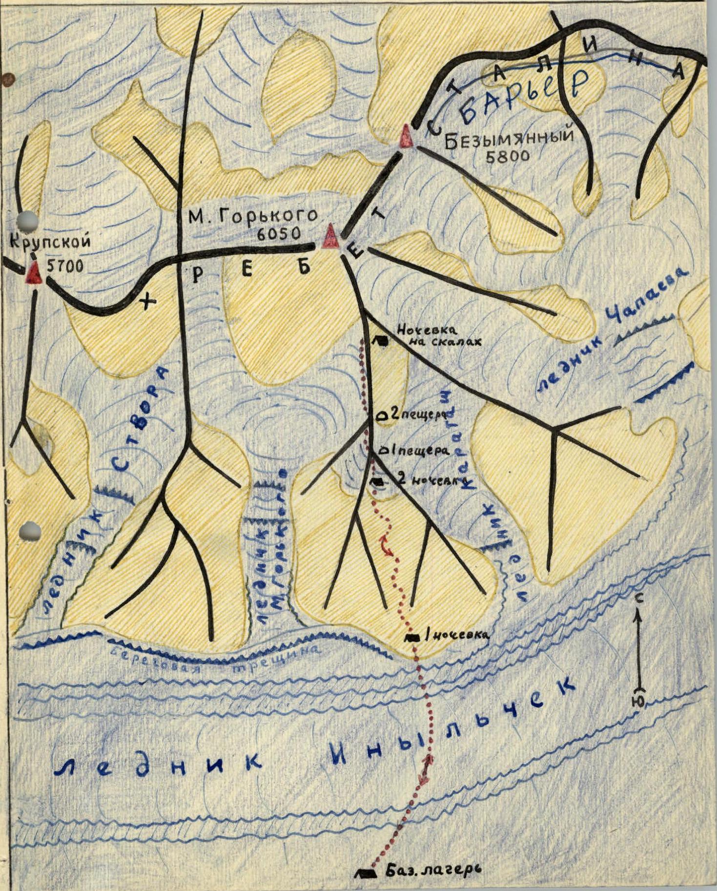
Orography and Glaciation
Peak Maksim Gor'kiy (6,050 m) is undoubtedly one of the most technically challenging peaks in the vast mountain range of Tien Shan. This beautiful peak rises above the middle part of the Stalin Ridge, with Peak Chapayeva (6,371 m) to the east beyond a saddle, and Peak N. Krupskaya (5,900 m) — still unclimbed — to the west, beyond a sharp drop in the ridge.
Peak Maksim Gor'kiy has the shape of a giant trapezoid, sharply elevated above the ridge line. The summit ridge stretches from west to east for almost 2 km, with the highest point located in the eastern part, rising 150–170 m above the ridge.
Three lateral spurs descend towards the South Inylchek Glacier: — southeast; — south; — southwest.
Moreover, in their lower parts, these spurs branch out into a series of rocky ridges heavily glaciated, thus forming numerous rocky walls. The southeast and south spurs merge at around 5,900 m and then connect to the summit dome via a short ridge. All ridges are sharp and typically crowned with large cornices overhanging to the east. The southwest ridge extends to approximately 5,500–5,600 m, where it transitions into a steep edge.
To the east, the peak drops with a 1.5 km wall into the multi-kilometer cirque of the Chapayev Glacier. Between the southeast and south ridges lies a cirque with the Karatash Glacier.
On the southern slope of the peak, an even larger cirque has formed, featuring a classically expressed cirque basin. The Maksim Gor'kiy Glacier descends through its threshold, forming a large icefall. The southern wall of the peak is at least 1,500 m high. Finally, between Peak M. Gor'kiy and N. Krupskaya, there is another cirque that has cut through the ridge more than the others, resulting in a significant depression in the ridge crest down to 5,400–5,500 m; however, it cannot serve as a pass due to its completely vertical walls over 200 m high on both the south and north sides.
All the described lateral glaciers belong to the South Inylchek glacier basin. The northern side of Peak Maksim Gor'kiy is much less explored than the southern side due to the inaccessibility of the Reznichenko Glacier (North Inylchek).
The brief information provided below was obtained during ascents by climbers from the Kazakh Club to Peaks Bayankol and Semenov, from where they were able to observe the upper reaches of the Reznichenko Glacier and the northern side of Peak Gor'kiy.
The northern side of Peak M. Gor'kiy is even more imposing than the southern side — a gigantic rocky cliff with almost no snow retention stretches from the summit ridge into the cirque of the South M. Gor'kiy Glacier. This wall is completely inaccessible. From the western shoulder of the peak, a steep edge extends northward, transforming into a spur that separates the M. Gor'kiy and N. Krupskaya glaciers.
Scheme of orography and route to Peak M. Gor'kiy (6,050 m) of the Kazakh Club expedition in the summer of 1959. The scheme was compiled by M. Grudzinskiy.
History of Exploration
The name of the great Soviet writer Maksim Gor'kiy was assigned to the peak by the leader of the Ukrainian expedition, M.T. Pogrebetskiy, in 1930. Since then until 1959, there was no attempt to climb the peak, as its wild, "razor-sharp" ridges deterred climbers.
During expeditions to the Peak Pobeda region in 1955 and 1956, Kazakh climbers thoroughly scouted the route to Peak Gor'kiy. After conducting a training camp in the Bayankol region in 1957, where a team of young high-altitude climbers was prepared, it was decided to organize an ascent to Peak Gor'kiy in 1959. The Kirghiz Sports Union participated in this expedition organized by the Kazakh Club of Alpinists and Tourists.
Ascent Description
The sports group of the joint expedition — the Kazakh Club of Alpinists and Tourists and the Kirghiz Sports Union — from August 1 to 9, 1959.
Consisted of:
- Tsverkunov V.S. — group leader, Master of Sports of the USSR
- Usenov U. — deputy group leader, Master of Sports of the USSR
- Savukhin V.V. — participant, 1st sports category
- Yeropunov A.N. — 2nd sports category
- Dengnik O.M. — 2nd sports category
- Maryashev A.N. — 1st sports category
- Vododokhov A.A. — participant, 2nd sports category
- Kuderin S.D. — 2nd sports category
- Kuklichev B.R. — 3rd sports category
- Krasil'nikov B.V. — 2nd sports category
- Kireev G.P. — 2nd sports category
- Tagabergenov M. — 2nd sports category
The sports group members departed from the base camp at 4,030 m on the South Inylchek Glacier on August 1, heading towards the northeast couloir that leads to the southern ridge of Peak M. Gor'kiy.
By 19:00, having overcome the Inylchek Glacier cut by gullies, as well as the median and main lateral moraines, the climbers reached the base of the aforementioned couloir, where they stopped for the night.
August 2. Departure at 7:00.
The couloir is initially scree, made of schist rocks, with a 40° slope. The slope gradually increases. From a height of 4,300 m, the slope increases to 50°, and the path passes through a snowy deposit. Several rocky outcrops are overcome, each 2–3 rope lengths, with rocks of average difficulty. At a height of 4,600 m, the slope reaches 60–65°; the snow hardly clings to the ice base, and steps have to be cut. Before reaching the ridge, a rocky section (3 rope lengths) is traversed. The rocks are of average difficulty. After the rocks, we reach the beginning of a snowy-ice slope. The path goes along an ice slope with a 65° angle (1 rope length). At the exit, a cornice has to be cut through. This section is traversed with step-cutting.
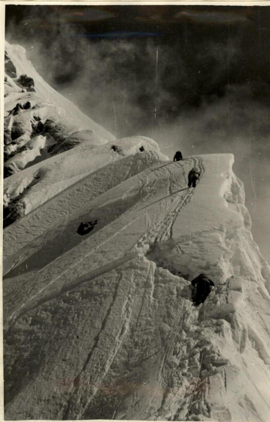
Throughout the entire route, snow cornices overhang to the east.
From the beginning of the snowy-ice slope, the southern ridge stretches with a 50° angle, dropping steeply to the west and with cornices to the east.
After 2 rope lengths, the slope increases to 60°, then decreases to 50°, and again there's a rise of 1 rope length with a slope of up to 70°.
The snow is loose, holding very poorly because it lies on an ice base.
After 3 rope lengths, the slope decreases to 50°. Then follows another ascent with a slope of up to 60° (1 rope length), where an ice cliff is overcome. It's necessary to proceed in crampons. The snow is loose and doesn't hold at all.
The weather quickly deteriorates. It's snowing. In the fog, we reach a more gentle slope, where we start digging a cave at 13:00. The height is 5,150 m. By evening, we hoist the backpacks into this cave. By 19:00, everyone is in place.
August 4. The weather is not good — we rest. It's snowing. Fog is rolling in. A west wind is blowing.
August 5. The weather is still not cooperating. Cloudy, cold, a lot of snow has fallen, and it's blowing. Winter has arrived. We departed at 9:00.
Directly from the cave, a snowy-ice slope rises with a 50° angle (1 rope length).
Then the slope decreases to 50° (2 rope lengths). We overcome an ice crevasse 2 m wide. The slope increases before the crevasse to 60°. After the crevasse, there's an exit onto a snowy-ice slope with a 70° angle (1 rope length) — traversed with step-cutting. We reach a sharp ridge, dropping steeply on both sides with 60° angles (1 rope length).
Further, the slope decreases to 45°, and then there's another rise of 1.5 rope lengths with a slope of up to 70°.
To the right, in the direction of the east, dangerous cornices hang. The snow is loose and very loose, holding not at all. To the left, snowy-ice cliffs drop with rocky outcrops every 30–40 m.
Bad weather is approaching again from the west. Everything is shrouded in dark and heavy clouds. Nansen has already put on a cap of clouds.
Further, there's a bend, and the slope decreases to 30–35° (2 rope lengths). We overcome closed ice crevasses and an ice slope with a 70° angle (1 rope length) with step-cutting. At the exit, the slope reaches 80–85°. This ascent ends with a dome-shaped rise, convenient for a bivouac.
After 2 rope lengths, a new snowy-ice ascent begins with a slope of up to 75°. Here, we dig a cave (5,300 m). Four people continue to process the route further. Ice crevasses are overcome, and the ascent takes 2.5 rope lengths (1 rope length is traversed with step-cutting). When moving from the snowy cave at a height of 5,300 m and up to the base of the rocks, the route goes along the ridge with steep ascents and cornices. One must move very cautiously, taking a significantly leftward path. The line of cornice break-off is not always determinable in poor visibility. To the left, a wall. To avoid going along the edge of the wall, participants made several exits onto a more gentle section — the edge of the cornices — and walked along dangerous sections from one ice ascent to another. As a result, there were 2 falls from cornices. Later, the group took this danger into account and moved significantly to the left (in the direction of travel).
At 12:00, snowfall began, visibility decreased, and the wind was westerly.
At the exit, the ascent has a slope of up to 85°. To the right, huge cornices hang.
Further, for 1 rope length, the ridge has a slope of up to 70°. To the left, smoothed rocky outcrops protrude. The ascent is complex and dangerous. Loose snow lies unsteadily on the ice.
Then follows a bend of 0.5 rope length with a 30° slope. The path continues along a steep slope to the left of the cornices.
There's a small ascent of 10 m with a 40° slope, after which the ridge has a slope of up to 70° for 2 rope lengths. To the right, there are cornices; to the left, there are cliffs.
Visibility is very poor; it's sleeting, with strong winds. By 18:30, we return to the cave. 6 rope lengths have been fixed. The weather has deteriorated completely. The wind is howling. A snowstorm is raging.
August 6. Wake-up at 6:00. Strong drifting snow. Westerly wind. Frost. The sky is partly clear. The summit of Peak M. Gor'kiy is hidden in clouds.
Below, on the glacier, all moraines are covered with snow. A cold snap has set in. Equipment is frozen. We traverse the processed section along the fixed ropes.
Steep 70–75° ascents with cornices to the east and rocky cliffs to the west begin. Bad weather is quickly approaching. We traverse a section of 2 rope lengths with a slope of up to 80° at the exit, with step-cutting.
Further: — the slope decreases to 60°; — we begin to ascend onto a huge snowy cornice, the so-called "lion's mane," with a slope of up to 70° (2 rope lengths).
After that, there's a sharp saddle leading to a rocky ascent with an 80° slope, covered in ice.
The height is 5,500 m. Strong bad weather forces the group to stop processing and descend to the 5,300 m cave.
Simultaneously, an additional delivery of fuel was made from the 5,150 m cave to the 5,300 m cave.
August 7. Wake-up at 5:30. On all peaks, huge snowy flags are waving. Drifting snow is blowing. Everything is swirling. It snowed at night. We take with us:
— warm clothing; — sleeping bags.
The route to 5,500 m has already been processed. Dark clouds are approaching from the west. Nansen is covered. Yesterday's tracks have been covered with fresh snow.
It's very cold. Feet are freezing. Ropes are frozen and inflexible. As on previous days, avalanches from the slopes are constantly rumbling.
We proceed along the tensioned ropes to the so-called "lion's mane."
The weather is deteriorating. Fog, snow, wind have rolled in, and visibility has decreased.
After the "lion's mane," we traverse a sharp ice saddle and ascend to the first rusty rock with an 80° slope (1 rope length).
The rocks are smoothed and covered with an ice crust. We have to chip away the ice and, using the smallest holds and rock pitons, carefully climb upwards. To the left, cliffs drop; to the right, cornices overhang. It's difficult and very dangerous to proceed.
We overcome a series of crevasses between steep rocks and snowy cornices.
After half a rope length, there's a small bend, and then another ascent with a slope of up to 75° for 1.5 rope lengths, with the overcoming of ice cavities.
All ice sections of the ascent are traversed with step-cutting. After this ascent, the slope decreases to 50°. There are rocky outcrops for belays and rope fixing. The path goes along the ridge. All the time, huge cornices overhang to the right, and cliffs drop to the left.
After 1.5 rope lengths of a snowy-ice slope with a 70–75° slope, there's another rocky outcrop convenient for belay.
The snow lies very unstably on a rocky-ice base. Further, there are 3 more bends with a total length of 2.5 rope lengths, each with a slope of up to 70°.
Up to the depression and at the beginning of the ascent, the snow is very loose, and one has to constantly dig trenches.
At the outcrops, step-cutting is applied each time.
Then follows another ascent with a 60° slope (1.5 rope lengths) with rocky outcrops. The rocks are icy, without outcrops, and the belay is very unreliable.
Bad weather relentlessly pursues the group. All the time, there's fog, stinging snow, and a cold west wind.
Along a snowy-ice ridge with a 70° slope, we ascend for 4 rope lengths in the direction of the summit of the so-called "rocky tail." The ascent is traversed with step-cutting and piton placement. At the exit of this ascent, the slope increases to 80–85°. At the same time, a rocky wall is traversed, representing a smoothed rock covered in ice, with an 80° slope (1 rope length), and then there's no holds.
It's traversed with great tension. It's already getting dark, and there's no sign of a suitable place for the night ahead, although according to reconnaissance data, a convenient spot for a bivouac was expected here behind a rocky outcrop.
The group emerges after the rocky wall onto a sharp rocky ridge leading to the right towards a rocky outcrop. The ridge has an overall ascent angle of 60–70° (1 rope length) and is traversed on top.
Further, this ridge abuts a rocky outcrop, which is bypassed on the left with a descent along a rocky wall for 3 m into an ice couloir, where further ascent takes place. The couloir has a 75° slope and is traversed with step-cutting (1 rope length). From the couloir, we exit onto a sharp ridge with snowy cornices to the east.
From the ridge, an ascent begins slightly to the left upwards along an ice wall with an 80° slope, with step-cutting.
Thus, another 1.5 rope lengths are traversed. It's already completely dark, and all hopes for a comfortable night are exhausted. The group settles in 3 different places: — The first rope team digs a niche in the ice approximately at a height of 5,750 m; — The second rope team settles 60 m below; — The rest of the group is even lower.
Having fixed pitons and secured themselves and their backpacks, the climbers tension sleeping bags around themselves. Thus, they spend the night in a semi-sitting position. Underfoot, chasms shine down to 2 km, and vertical walls rise upwards.
August 8. The night passed uneventfully. The wind was not strong, and not much snow fell.
At dawn, the group resumed its work. The sky is again covered with clouds. The sun is hidden. The west wind is strengthening.
There's an ascent of another 1 rope length along the ice wall with an 80° slope, with step-cutting. After that, the group reaches a small bend and begins an ascent to the right upwards along a snowy-ice slope with a slope of up to 70° (1.5 rope lengths).
At the top, a 5-meter cornice is cut through. Further, there are 3 ascents with a total slope of 60° (2 rope lengths); the snow is loose, fresh, and holds very poorly.
Further, the ascent proceeds along a snowy-ice wall with a 70–75° slope (3 rope lengths), leading to the southern shoulder of Peak M. Gor'kiy, at a height of 5,900 m.
It's 14:00; the weather sharply deteriorates. Clouds cover the summit. Strong wind and stinging snow blind and hinder forward movement. Visibility is poor. To the west, everything has darkened. By order of the group leaders, due to the deteriorating weather, the assault is halted. The group began its descent at 14:30.
From the point reached by the group, a wide snowy ridge with huge cornices overhanging to the east leads to the main summit of Peak M. Gor'kiy (6,050 m). With good weather, this path can be traversed in 4–5 hours.
The group descended to the 5,300 m cave by 19:00. The descent was conducted under conditions of extremely bad weather, very poor visibility, and was exceptionally difficult and dangerous.
Ice cliffs and continuous snowy cornices forced the group to move very cautiously. Clothing and equipment were covered in ice. Faces were encrusted with ice and dangling icicles.
At 21:00, a green flare was fired because radio communication failed. A response was received from the base camp.
August 9. The bad weather continued throughout the night. A strong snowstorm made it impossible to exit the cave. By mid-day, the wind became calmer. At 14:30, the group began its descent.
The snowstorm made it impossible to see ahead. From the stinging snow and wind, eyelids swelled, and eyes hurt. One had to squint constantly. Snow penetrated everywhere — under the collar, under the clothes, into the sleeves — and unpleasantly chilled. A continuous "milk" completely obscured the descent path. One had to proceed almost by touch, bending low to the surface to see anything.
Often, descents were organized with the help of a withdrawable ice axe. Finally, we reached the 5,150 m cave, where we took a short rest. The weather hadn't changed; we decided to continue descending. The snowstorm was so strong that those following behind could no longer see the tracks of those ahead. Visibility was nil. Ropes strained, trying to shout over the wind, gave signals to each other with sound.
A few more descents, and the group approached the second overnight stop. The sites were completely covered in snow and almost invisible. — A descent into the couloir was organized via fixed ropes. By around 17:00, gaps appeared in the clouds; the fog began to clear, and visibility improved, but within an hour, everything was shrouded again, and sleet began to fall. By 20:30, the group reached the base camp.
Having considerable experience with high-altitude and highly complex ascents, the group determined that this route to the shoulder of Peak M. Gor'kiy (5,900 m) along the southern ridge is extremely complex and dangerous and, considering:
- the height;
- the extent of the route;
- the duration of work at altitude;
- the technical difficulty (ice, rock, snow) at high altitude;
- the exceptional danger (slope angles up to 85°, the route almost continuously passes along cornices);
- the lack of sufficient reliable belay points;
- the absence of convenient places for organizing overnight stays at altitudes from 5,300 to 5,900 m;
- the remoteness of the ascent area and complex meteorological conditions, believe that this route can be classified as category 5B.
The description was compiled by: V. Tsverkunov (section "Ascent Description") and M. Grudzinskiy (sections: "Orography and Glaciation" and "History of Exploration").
Photos by: B. Kuklichev, M. Grudzinskiy, U. Usenov.
Verified against the original — November 25, 1960. M. Grudzinskiy.
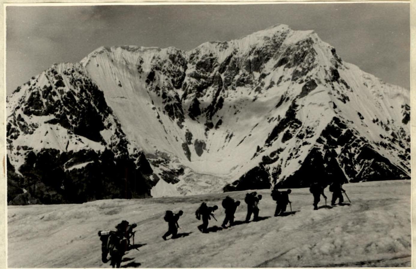
 Approaches to Peak M. Gor'kiy via the Inylchek Glacier.
Scheme of the ascent route to Peak M. Gor'kiy (Stalin Ridge, Tien Shan) from August 1 to 9, 1959.
Threshold of the 2nd ascent (5,400 m).
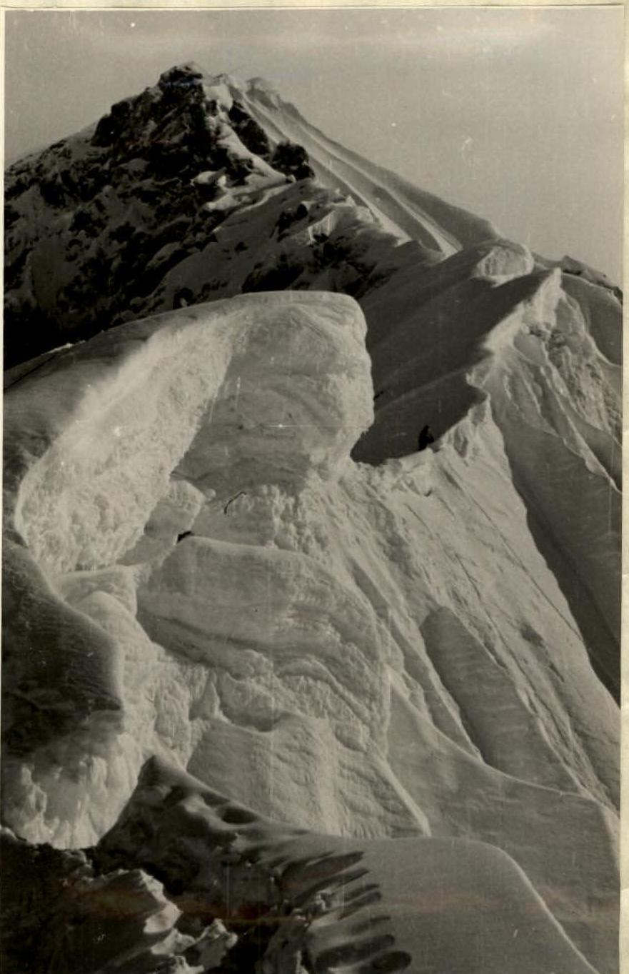
Southeast ridge of Peak Gor'kiy, height 5,500–5,600 m.