
To the Chairman of the Presidium of the Alpinism Federation of the Kirghiz SSR
Comrade Smirnov Yu.N.
From the participants of the traverse of the "Choktal" massif Comrades Buryak V.N., Aksenov V.A., Lengnik O.M.
Petition
In 1962, a sports group led by Naumenko I.M. completed a traverse of the "Choktal" massif, category 5B.
The group followed the route with some deviations from the original route due to the lack of a complete and detailed description. In connection with this, the group made independent decisions on the choice of path in certain sections of the traverse.
The group members removed notes from all the peaks of the massif and control tours. In the group's opinion, the deviations made from the classified route do not affect its category of difficulty.
When reviewing the group's traverse, the commission (chaired by Rotataev N.S.) proposed that we compile a detailed description of the route taken and consider it at the Presidium of the Alpinism Federation of the Kirghiz SSR.
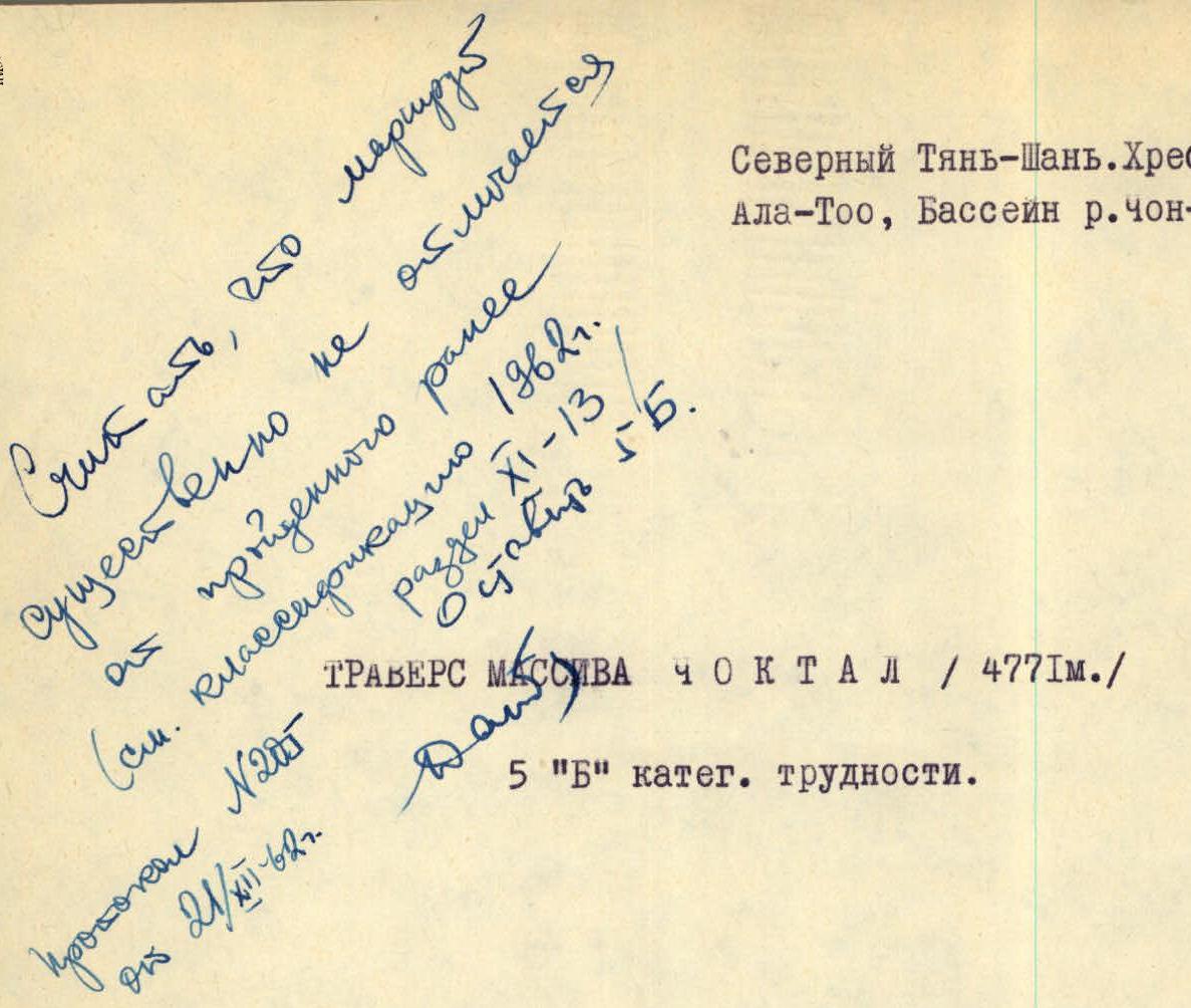
In this regard, the group petitions for the classification of the route taken and consideration of the traverse results. October 20, 1962.
Northern Tian Shan. Kungey-Alatoo ridge, Chon-Kemin river basin.
Description compiled by:
- Buryak V.N.
- Aksenov V.A.
General Information
The Kungey-Alatoo ridge is located in the northern part of Tian Shan and is far from major centers and alpine camps of the Kirghiz SSR. Due to this, most of the ridge's peaks remain unconquered, and those that have been climbed are rarely visited.
Alpinists began to explore the ridge, mainly its high part, the Choktal massif, in 1937. That year, the II Western peak of the massif was conquered via the eastern ridge. In 1950, participants of Chekmarev's expedition made ascents to the II Eastern peak via the western ridge and to the II Western peak via the southwest ridge.
In subsequent years, the Choktal area was visited more frequently. For example, the Aleksashin group completed a traverse of the massif from east to west, category 5B. This route was entered into the USSR championship in the traverse class and ranked 6th. Later, in 1960 and 1961, Kyrgyz alpinists visited the Choktal area. Due to the lack of a detailed description and other circumstances, the ascents in 1960 and 1961 were made with deviations from the route and violations of the "Rules".
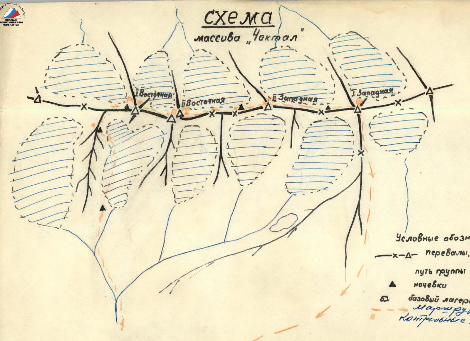
The Choktal massif consists of 4 peaks located in a latitudinal direction and has a significant length of 7-8 km. The northern slopes of the peaks descend to the glaciers of the Dzhindysu river basin, which flows into the Chon-Kemin river - a powerful mountain river that separates the slopes of the Trans-Ili Alatau and Kungey-Alatoo ridges. The southern slopes are less steep and descend to Lake Issyk-Kul. To the west and east, the massif is flanked by peaks that are less interesting from an alpinism perspective.
The peaks of the massif are united under a single name because they are located close together and stand out from other peaks in the ridge due to their height (about 4800 m). The massif can be divided into two parts - eastern and western - due to a relatively wide (about 2 km) and low depression in the ridge. Hence the names of the peaks: I and II Eastern and I and II Western peaks of Choktal.
The highest peak is the I Eastern peak, with a height of 4771 m according to the latest data. The peaks of the massif are of significant interest to alpinists. For example, ascending the I Eastern peak via the northern wall is undoubtedly a challenging task.
Traversing the peaks of the massif in both directions is also a complex task. The complexity of the traverse is evident at first glance. One cannot help but notice the deep gaps between the peaks and the complex ridge leading to the I Eastern peak from the east. The traverse route is combined, featuring:
- steep snow slopes,
- ice slopes,
- rocky slopes.
The most challenging part of the route is the ascent and traverse of the eastern peaks from the east. The traverse of the remaining part of the massif also abounds with complex sections, though less extensive.
Given the length and significant number of complex sections, the traverse of the massif should be classified as one of the most challenging routes in the Northern Tian Shan.
Due to the proximity of Lake Issyk-Kul, the weather in the area is characterized by instability. The group managed to complete the route in relatively good weather. The approaches to the massif are lengthy and straightforward.
Route Description
From the city of Frunze, take a car via the Pupsky tract to the Boom gorge and then through the Semyonov bridge along the Chon-Kemin gorge to the village of Novorossiysk. From the village, drive up the gorge for about 60 km until the end of the road. The end of the road is located in the forest zone, where there are many suitable places for a base camp.
Then, walk about 1 km upstream, to the right along the Chon-Kemin river. Climb up the step-like slopes to the right until reaching the Dzhindysu gorge. Before reaching the terminal moraines, cross the Dzhindysu river and move towards the already visible I Eastern peak.
The ascent via the moraine is relatively straightforward. Then, move along the glacier in rope teams.
A bivouac is set up a little above the glacier tongue (to the right). The journey from the base camp to the bivouac site takes about 5 hours. The left eastern Dzhindysu is bounded on the left (in the direction of travel) by a counterfort leading to the I Eastern peak, and on the right by a counterfort leading to the II Eastern peak.
Climb up the glacier to the icefall descending from the saddle between the counterfort and the main ridge. The approach to the icefall takes about 30 minutes from the bivouac site.
Upon reaching the icefall, cross the bergschrund (via a bridge) to the start of the couloir located to the left (in the direction of travel) of the icefall - 20 minutes. The first 30 minutes along the snow-covered scree present no difficulty; thereafter, the path becomes more challenging. The steepness increases from 30° to 50°, and there is serac ice. Over a distance of 50-70 m, it is necessary to cut steps and use piton protection. The first rock wall is ascended using ladders. The rocks are of the "sheep's forehead" type, with a steepness of about 65°.
From the wall, move left and upwards 15-20 m along scree ledges to an overhanging 10-meter wall. The wall is covered in serac ice, and the rock character is similar to the previous section. It is not possible to bypass it on the left or right. Passing the ice-covered wall is the key section of the ascent to the counterfort saddle.
Further on, the steepness decreases somewhat. It is necessary to ascend along serac ice for about 200 m, cutting steps and using piton protection. The ice slope ends with a narrow throat in the form of a 6-meter rock wall with ice, at 70°.
Then, the couloir widens again into a steep, wide ice slope of 60-65°, extending for about 300 m. The ice is serac and covered with a thin layer of snow. At the top of the slope:
- Move left along rocks for 40 m onto a snow-ice ridge,
- Then ascend along the ridge leading directly to the counterfort ridge.
The ascent along the slope to the start of the ridge took 2 hours 30 minutes. The ridge, about 120 m long, is steep (up to 65°) and took 1 hour 30 minutes.
At the point of exit onto the counterfort, the ridge is wide, and a I control tour is built in a visible location. Climb up two snow ascents (30-40 m each, at 50°). Then, there is a ridge; a rock wall 60 m - 55°. The rocks are of moderate difficulty. After the wall, the ridge becomes gentler for 20 m and then there is another rock wall 15 m high. The rocks are of moderate difficulty.
After the wall, it is necessary to bypass a gendarme on the right. There is a convenient place for a bivouac behind the gendarme. A night's stay is organized here.
The journey from the first bivouac took the group 12 hours. The following were used:
- 14 ice pitons
- 10 rock pitons
From the bivouac, it is necessary to ascend to the saddle along a relatively straightforward rock ridge about 80 m long.
The path from the saddle to the main ridge is an ice-snow slope-ridge with a steepness of 35° and a length of 50 m.
To the east, the main ridge descends, transitioning into a saddle, from which a gentle snow slope leads to an unnamed peak, beyond which another peak is visible. The distance from the point of exit onto the main ridge to the unnamed peak is within 400 m.
Our group considered it illogical to ascend this peak during the traverse of the Choktal massif since it is not part of the massif. In the group's opinion, this section, previously traversed by the Aleksashin group, does not affect the category of difficulty of the route.
The ridge leading to the I Eastern peak is steep (35-45°). To the north, it is bounded by walls with giant cornices overhanging them; to the south, by steep snow-ice slopes with a steepness of about 60°. The ridge is narrow, and the presence of serac ice greatly hinders movement. It is necessary to move strictly along the ridge, near the line of cornice detachment, cutting steps and driving in ice pitons.
The length of this labor-intensive section is 300 m. The snow-ice ridge ends in a gap, and the descent into it is made "in sports style" for 35 m. Then, bypassing a large stone on the left, descend onto a small snow "pocket" about 15 m long. Further, there is a 10-meter ice slope at 60° to the saddle of the gap. From the gap, the ridge rises with a 45-meter rock wall, then ascends in steps for another 30 m.
The rocks are very difficult. The first person must ascend without a backpack becomes a rigger. With careful piton protection, overcome the wall. Further, the path becomes simpler.
- Vertical ascents - 3-4-meter walls have a difficulty above average.
- After the ascent, there is a descent along a steep (45°) snow couloir (10 m).
- Then, a small, narrow snow ridge, when exiting which from the couloir, it is necessary to move along the snow slope, holding onto the rocks.
- The ridge leads to a steep rock ascent, which is bypassed along a steep (50°) snow patch on the left.
- The snow patch leads to a ledge, from which the rest of the group can be belayed.
Further, the ridge ascends and represents a series of gendarmes, most of which are taken "head-on". The length of this section of the ridge is about 500 m.
Before the last two ascents to the peak, a bivouac is organized. The snow-rock section of the ridge gives way to a purely rock section, as if composed of individual rock blocks 1.5 m high. The stones are without cracks, and the gaps between them are too wide for pitons. For protection, ice pitons are used. The length of this section is 50 m. The rock ridge turns into a snow ridge, leading to the saddle. To reach the saddle, descend along a smooth inclined slab ending in a negative wall (5 m) below. The ridge becomes rocky again.
The next gendarme is bypassed on the left along the snow. After that, a steep snow ascent leads back onto the ridge (20 m). The path along the ridge is 30 m to a snow cornice, which is bypassed on the left. The exit to the I Eastern peak is along a straightforward snow-rock ridge (40 m).
The descent from the peak is "in sports style" (40 m) to the west. Then, traversing a steep (45°) ice slope (60 m), exit onto the ridge. About 20 m along serac ice, descend with step-cutting. Further, the descent is "in sports style" for 60 m along a rock-ice slope (50°).
The ridge becomes gentler, and after 60 m, reach the junction of the southwest counterfort with the main ridge. The ridge is very jagged; movement along it is very challenging. Downward, there is an ice couloir (50°, 60 m). The couloir becomes gentler and turns into snow. Cross the couloir from left to right, and then the steepness increases again. Another descent "in sports style" is organized for 50 m to the saddle between the I and II Eastern peaks. The descent takes 2 hours.
From the saddle, along an ice slope 100 m (40°), approach a rock ascent 250 m, 50°. The rocks are of medium difficulty, and in the upper part, 20 m - "in the chimney". Exit onto the northern peak of the II Eastern peak. The descent to the saddle is 40 m along straightforward rocks. From the saddle, traversing an ice slope (40°, 150 m), approach an ice couloir (50°, 50 m) leading to a shoulder.
Then, along a steep rock-ice ridge (100 m), ascend to the southern peak. The descent to the shoulder is via the ascent route. Further down, "in sports style," descend along rocks to the start of the ice slope. The ice slope, 100 m long (50°), is traversed:
- with piton protection,
- on crampons.
Then, a large rock gendarme is bypassed on the left along an ice couloir (40° - 80 m). Further, along a gentle snow ridge (100 m) and down along a rock ridge. On the rock ridge, there are individual sections of smooth walls requiring attentive and technical climbing. After 200 m, the ridge drops steeply. A descent "sitting" is organized onto a snow patch (40 m). The snow patch is not steep, but there is ice underneath. With step-cutting (15 m), descend further and then along a straightforward ridge to the saddle between the II Eastern and II Western peaks. A bivouac is organized.
The ascent to the II Western peak of Choktal begins along a steep ice slope (from 30°-55°, 400 m long). The slope is overcome on crampons and with piton protection. Further, there is a long, tapering, gentle ridge leading to a rock wall. The wall is bypassed on the left. From the ridge, traverse left and down, crossing two ice couloirs with step-cutting and piton protection, exiting onto a horizontal rock ledge (80 m). The ledge leads to a rock wall (15 m, 65°). Then, a short traverse along rocks of medium difficulty to the left (40 m). Then, up along rocks of the "sheep's forehead" type, ascend with piton protection for 40 m. Approach a 10-meter sheer inner corner. The corner leads to a ledge. Along the ledge, traverse right and exit onto the ridge.
The exit is challenging and requires careful piton protection. On the ridge, there is a small platform from which ascend along the wall of a gendarme (40 m, 75°).
The descent down to the saddle is straightforward. From the saddle, ascend up along a wall of the same type as the previous one. Further, there is an ice ridge. In its middle, a sheer cornice overhangs to the left; it is bypassed on the left with step-cutting and piton protection (10 m).
The ridge leads to a rock wall (65°, 40 m) composed of slabs. The wall is ascended with careful piton protection. Then, exit onto the peak along an ice ridge (80 m, 50°) with piton protection. We are on the peak.
The tour is located on the western side of the plateau. The descent from the peak to the saddle is along an ice slope (80 m, 45°). The slope becomes gentler, transitioning into a narrow rock-snow ridge. In the ridge, there is a gendarme taken "head-on" (12 m, 60°). Further, along a snow patch (50 m), approach the start of the descent to the saddle, to the right - a large rock gendarme. The descent is along an ice slope along the rocks (45°, 120 m). The slope becomes gentler (30°, 100 m), and further down along a straightforward rock ridge, descend to the saddle. A bivouac is organized on the saddle. From the saddle, there is a gentle snow ridge with a series of small gendarmes. Begin the ascent with a traverse to the left onto a well-defined inclined snow terrace leading to a bergschrund, which is passed relatively easily.
Then, along a steep snow slope (55°, 100 m), approach an ice wall (10 m, 60°), and then the ridge becomes gentler, leading to the peak dome. The peak is snow-covered, and the tour is built to the left below on the outcropping rocks. The descent is along the northern counterfort. 50 m along a steep snow slope. The slope becomes steeper, and serac ice appears. 140 m - descent "in sports style" along a steep (55°) ice slope.
The ridge becomes gentler. Along a snow patch, approach a gendarme bypassed along an ice couloir (40 m, 50°). Descent "in sports style". Then, move along a narrow, steep rock ridge. Protection is via outcrops (80 m, 60°). Approach a second massive gendarme, which is traversed on the left along challenging rocks.
The descent from the gendarme is 80 m "in sports style". Further down, left along a non-steep scree couloir, descend to the glacier (400 m, 55°).
It should be noted that the descent along the northern counterfort is more challenging than the descent along the western ridge. The group did not cross the spur of Choktal but descended down the gorge, traversing to the right across grassy slopes to the base camp.
The group members traversed the route with a movie camera but without a still camera. Therefore, the description includes landscape photographs and several photos from other groups.
The group classifies the route taken as category 5B. The deviations made by the group from the Aleksashin group's route, namely:
- Ascent to the main ridge along the northern counterfort to the left of the icefall.
- Ascent to the 1st peak, which is not part of the Choktal massif.
- Exit to the I Western peak along a snow-ice slope to the left of the ridge.
Do not significantly affect the category of difficulty. Breaking down the entire traverse into sections, it can be said that:
- The ascent route to the I Eastern peak corresponds to category 5A;
- The remaining part of the traverse also corresponds to a category 5A route.
The traverse was completed by a group consisting of:
- Naumenko I.M. - 1st category - group leader.
- Lengnik O.M. - Master of Sports
- Buryak V.N. - 1st category
- Aksenov V.A. - 1st category
Time calculation:
- Approaches from the base camp to the I bivouac - 8 hours.
- I bivouac on the glacier - II bivouac on the counterfort - 12 hours.
- II bivouac - III bivouac before the I Eastern peak - 12 hours.
- III bivouac - IV bivouac on the saddle - 9 hours.
- IV bivouac - V bivouac on the saddle between the Western peaks - 10 hours.
- V bivouac - base camp - 12 hours.
Total - 62 hours.
Equipment for a group of 4:
- Main rope - 2×40 m.
- Auxiliary rope - 1×40 m.
- Rock pitons - 18 pcs.
- Ice pitons - 8 pcs.
- Hammers - 1 pc.
- Ice axes - 2 pcs.
- Crampons - 4 pairs.
- Carabiners - 12 pcs.
- Rucksacks - 4 pcs.
- Harness belts - 4 pcs.
- Repschnurs - 6×5 m.
- Ladders - 2 pcs.
- "Pamirka" tent - 1 pc.
- Down jackets - 4 pcs.
- Sleeping bags - 2 pcs.
- Petrol stoves - 1 pc.
Note: A food cache was made on the saddle between the Eastern and Western peaks.
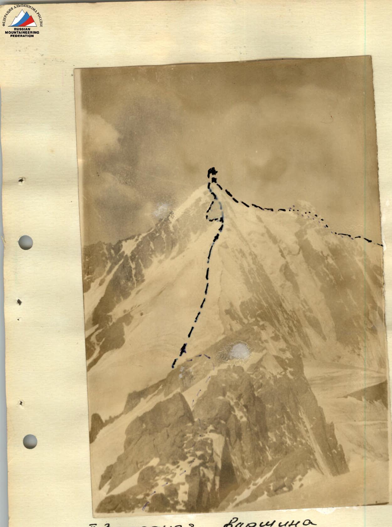
 I Western peak (view from the saddle)
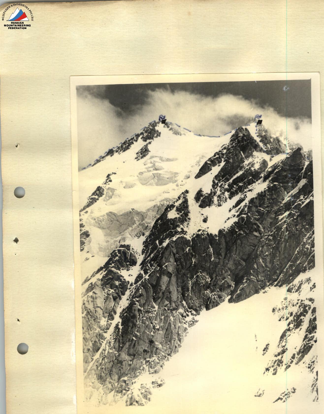
 II Eastern peak
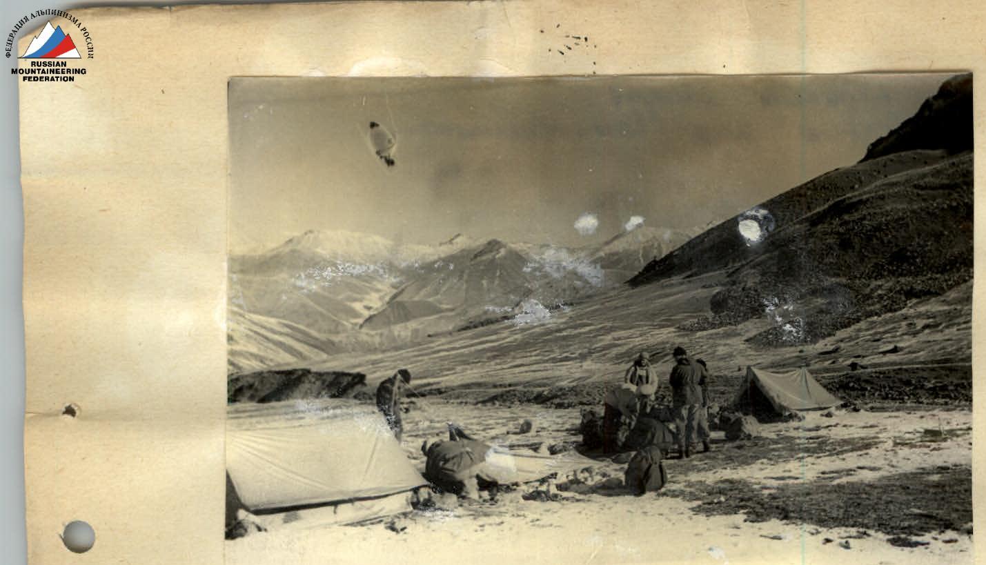
 Base camp under the moraine of Upper Dzhindysu. In the background is the Trans-Ili Alatau.
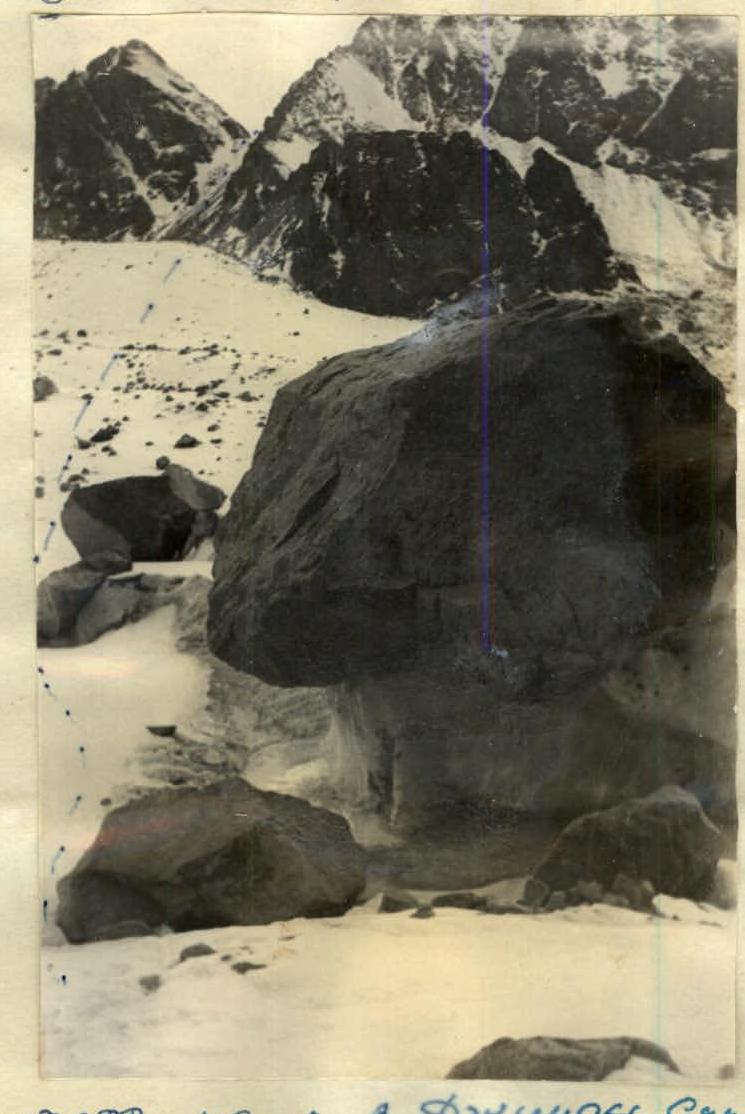
Ascent to Upper Dzhindysu glacier
Base camp under the moraine of Upper Dzhindysu. In the background is the Trans-Ili Alatau.
Ascent to Upper Dzhindysu glacier
Comments
Sign in to leave a comment