
Kungey Ala-Too Range
Northern Tian Shan
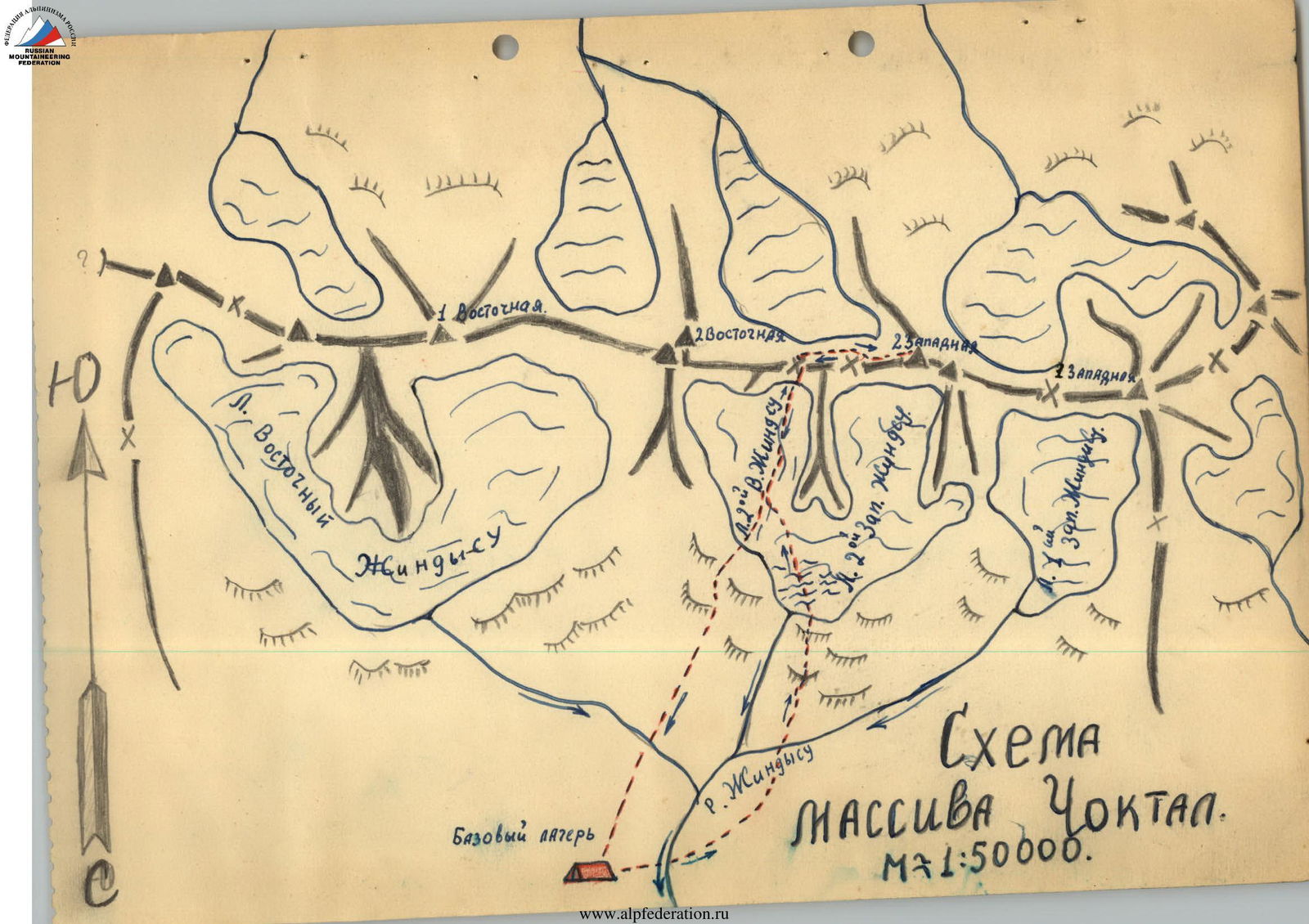
Choktal Massif
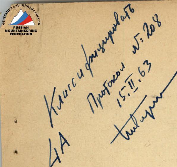
Peak 2nd Zapadnaya (West) 4771 m. Route 4A cat. diff. From glacier 2 V. Dzhindyku and then along the E. ridge
Description compiled by Kholodniak A.M.

General information about the climbing area: the Choktal massif is the highest point of the Kungey Ala-Too range in the Northern Tian Shan. Being far from major alpine camps, the area is rarely visited by climbers.
The first attempts to explore this area date back to 1937, when three alpine instructors ascended the 2nd West peak via the eastern ridge; the second attempt was made in 1950, when the Lokomotiv DSO expedition led by Chekmarev visited the Choktal area. The participants of this expedition conquered:
- 2nd East peak via the western ridge,
- 2nd West peak via the northwestern ridge.
However, no materials from these ascents have been preserved. There is no description of the routes to the 2nd East and 2nd West peaks of the Choktal massif in the mountaineering literature.
The northern slopes of the peak descend to the glaciers of the Dzhindy-Su river basin, which flows into the Kemin - a powerful mountain river that separates the slopes of the Trans-Ili Alatau and Kungey Ala-Too ranges. The southern slopes descend to Lake Issyk-Kul. To the west and east, the Choktal peaks are adjacent to less interesting peaks in terms of mountaineering, which are also significantly lower in height.
The Choktal massif consists of 4 peaks located in a latitudinal direction and has a considerable length of 7-8 km. The peaks are united under a single name as a massif. Apparently, they are 4 independent peaks with a distance of up to 2 km between them and deep saddles. According to recent maps, the height of the Choktal massif is 4771 m.
From the city of Frunze, one can reach the village of Novorossiysk in the Chon-Kemin valley by bus, and from Novorossiysk, one can drive another 60 km by car to the third bridge, counting from the bridge within the village of Novorossiysk. The third bridge is located in the Dzhava tract, approximately 8-10 km below the mouth of the Dzhindy-Su river. Further movement goes up the slopes of Kungey Ala-Too to the base camp site on the bank of one of the Dzhindy-Su tributaries.
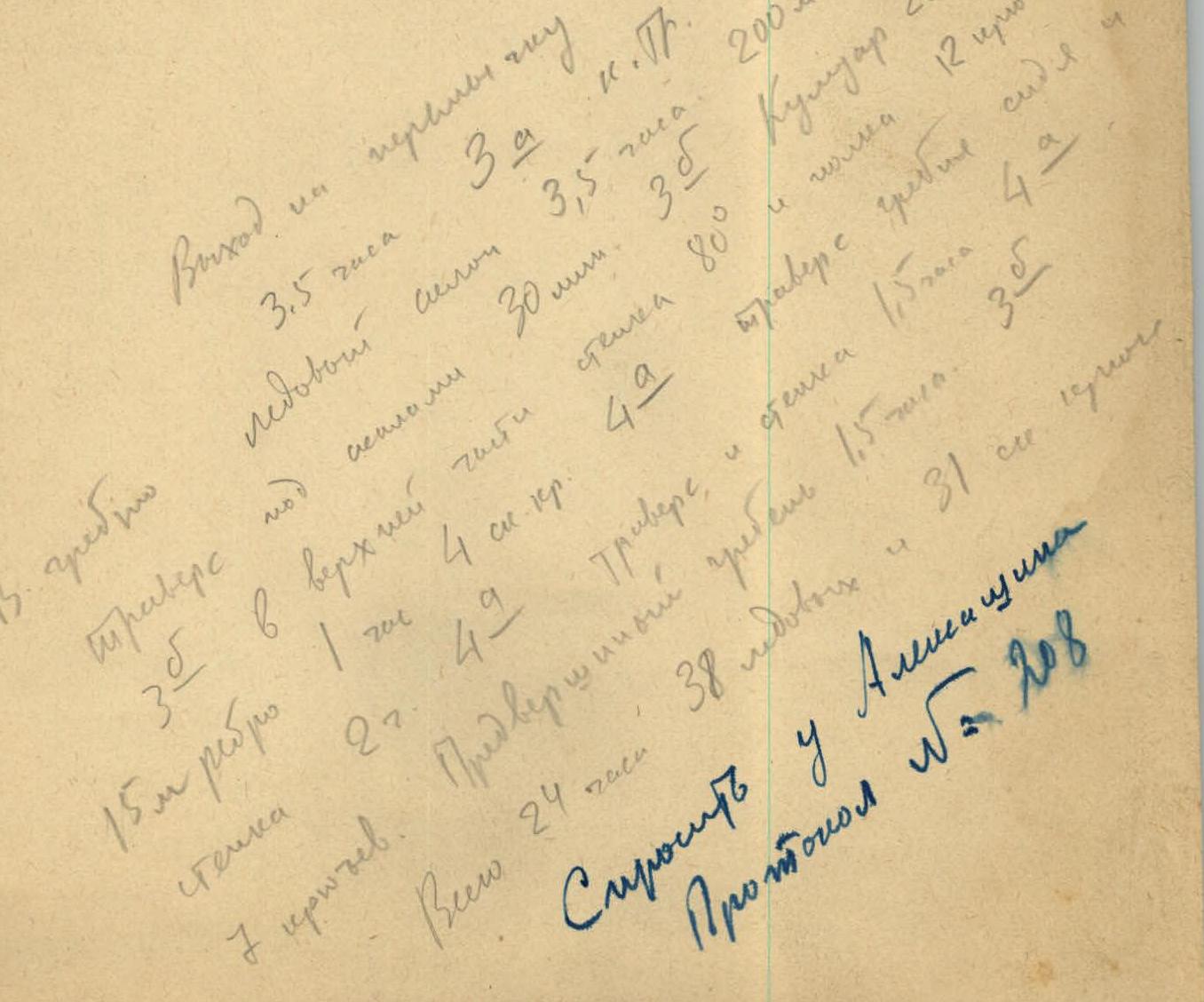
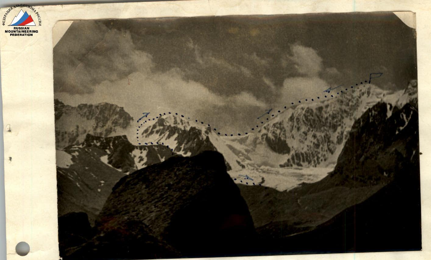
From the base camp, ascend towards the saddle between the 2nd East and 2nd West peaks. Initially, the route goes across grassy slopes, then across the moraine. The moraine is steep at first, but becomes gentler as you gain height. The glacier is covered with moraine in its lower part, and the moraine is mobile. The glacier in its lower part is heavily crevassed - this is a kind of small icefall that needs to be traversed in a rope team.
The 2nd West and 2nd East Dzhindy-Su glaciers are separated by a large counterfort extending from the saddle in a northerly direction. In their lower parts, these two glaciers merge. The further path goes along the 2nd East Dzhindy-Su glacier; the glacier is snow-covered, with crevasses. After crossing the entire glacier, you approach the saddle; the saddle is an icy slope.
In its lower part, the slope has a steepness of 30-35° and is snow-covered. In its upper part, the slope has a steepness of 40-45°, with no snow. The slope is 350-400 m long.
After 50 m, you overcome the marginal crevasse. It is filled with snow and is easily traversed. After another 100 m ascent up the shallow snow, you reach a rocky outcrop, where it is convenient to put on crampons. From here begins the challenging section of the icy slope. After 120 m, you approach the 2nd marginal crevasse. Its passage is much more complicated compared to the first one - the crevasse is traversed over a snow bridge. The remaining 150 m go along the icy slope with a steepness of 40-45°. The area is challenging. 12 ice screws were hammered in. Reaching the saddle took the group 3 hours and 30 minutes.
You reach the saddle.
- On the saddle, to the south, on the scree, a cairn is built.
- The saddle is a large, gentle area, sloping southwards across the scree.
- There is water on the saddle, making it convenient to set up a bivouac.
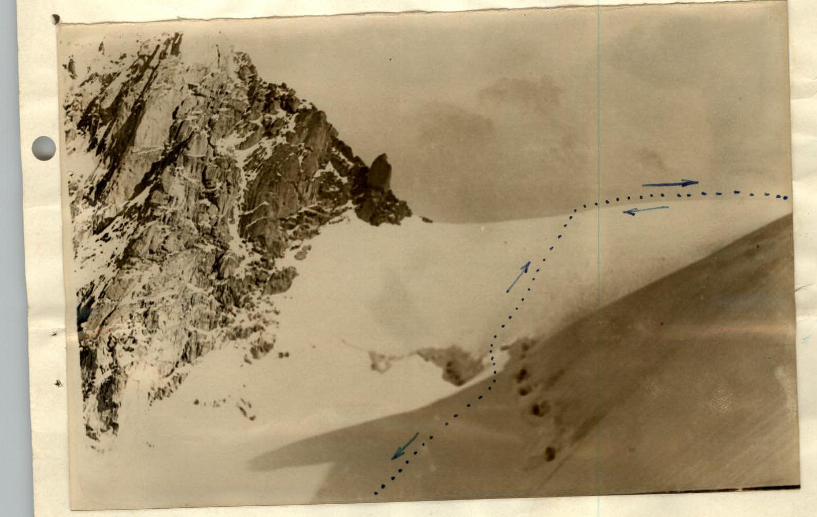
The further path goes along the eastern ridge of the 2nd West peak.
- Initially, along a steep snow-ice slope 300 m long.
- In the lower part, there are crevasses, so it is necessary to move in a rope team immediately.
- As you gain height, the steepness of the slope increases:
- In the lower part, the slope has a steepness of 30-40°, is 100 m long, and is snow-covered.
- In the upper part, the slope is 50-55° steep, 200 m long, with no snow, and is challenging: 15 ice screws were hammered in.
- The passage of the slope took the group 3 hours and 30 minutes in total.
- To the right, cornices overhang to the north towards the 2nd West Dzhindy-Su glacier.
The steep slope leads to a flat plateau 300 m long, which approaches the rocks. The rocks are bypassed on the left, losing 60 m of height. This section is ice with a steepness of 45-50°. After descending 30 m, you approach the rocky ridge, where a rock pit is hammered in, and continue descending across the ice, traversing to the right. On this section, 3 ice screws and 2 rock pits were hammered in. The time taken was 30 minutes.
After that, you reach a rocky inclined ledge 10 m long. From here, the path leads to a steep couloir with ice sections 3-5 m long, which require step-cutting. Characteristics of the couloir:
- The couloir is 55-60° steep and 250 m long.
- In some areas, the steepness reaches 70-80°.
- The couloir is narrow and prone to rockfall, so it should be traversed as quickly as possible. The rocks here are of medium difficulty. Alternate belays are required to traverse the couloir.
- In its upper part, the couloir turns into an internal angle 80° steep and 10 m long. The internal angle leads to a rocky inclined ledge 45° steep and 8-10 m long. From the ledge, you move to the right onto the ridge.
- The area is challenging: 12 rock pits were hammered in.
- The passage of the couloir took the group 4 hours and 30 minutes in total.
Before you is a 15-meter ridge 70° steep. The ridge is traversed with piton belays, 4 rock pits were hammered in, and the time taken was 1 hour. The ridge leads to a sharp rocky ridge 10 m long. To the left and right, there are sheer drops, making the ridge hazardous. The passage is made sitting astride with careful belays. Further, the ridge has several more challenging sections. The sharp rocky ridge leads to a snow-rock wall 70° steep and about 20 m long. On this section, 8 rock pits were hammered in, and the time taken was 2 hours. After passing the wall, you reach a shoulder, and before you is a snow ridge and a cornice. The cornice is bypassed on the left, and you reach an icy section 50° steep and 10 m long. The passage of this section is complicated by the difficulty of belaying; belaying is done through the waist. The icy section leads to a rocky wall 80° steep and 8-10 m long. The area is challenging: 2 ice screws and 5 rock pits were hammered in. The passage of this section took 1 hour and 30 minutes.
Finally, before you is the last snow-ice ridge 80 m long and 45-50° steep. Its passage is made with alternate belays, 6 ice screws were hammered in, and the time taken was 1 hour and 30 minutes. The summit is a fairly large snow plateau. To the west, there are rocks where a cairn is built. The descent from the summit is made via the ascent route. Thus, the ascent to the 2nd West peak took the group 24 hours in total. A total of 38 ice screws and 31 rock pits were hammered in.
The ascent to the 2nd West peak was made by a sports group of an expedition organized by the Alpinist Club of the Kyrgyz SSR in the following composition:
- Kolesnikov E., 2nd sports category
- Kholodniak A., 2nd sports category
- Veselov P., 3rd sports category
Equipment for a group of three:
- Main rope 1x40 m, 9 mm
- Auxiliary rope 1x80 m
- Rock pits 10 pcs.
- Ice screws 8 pcs.
- Hammers 2 pcs.
- Ice axes 3 pcs.
- Carabiners 10 pcs.
- Crampons 3 pairs
- Backpacks 3 pcs.
- Belts 3 pcs.
- Rope slings 3 pcs.
- Pamir tent 1 pc.
- Down suits 3 sets
- Sleeping bags 3 pcs.
- Storm suits 3 sets
- Primuses 2 pcs.
- Gasoline 3 l
According to the participants, the ascent to the 2nd West peak fully deserves a 4A category difficulty rating.
Diagram of the Choktal Massif. Scale 1:50,000.
Comments
Sign in to leave a comment