
70 Kungey Ala-Too Range Northern Tien Shan
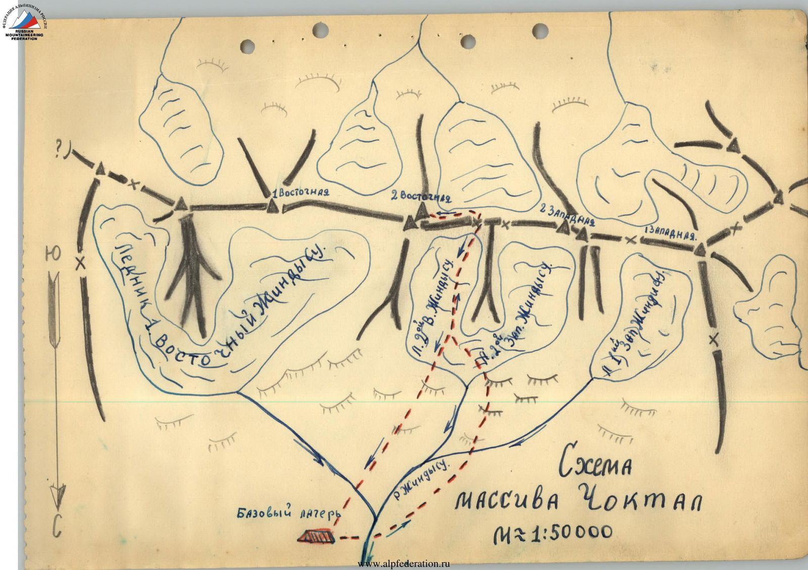
Choktal Massif
2nd Eastern Peak
- 4771 m
- Choktal Massif
- Category 3B difficulty
Description compiled by: Kholodniak A.M.
General information about the climbing area: the Choktal massif is the highest point of the Kungey Ala-Too range in the Northern Tien Shan. Being far from major alpine camps, the area is rarely visited by climbers. The first attempts to explore this area date back to 1937, when three alpine instructors climbed the 2nd Western peak via the Eastern ridge. The second attempt was made in 1950, when a DSO "LOKOMOTIV" expedition led by Chekmarev visited the Choktal area. The participants of this expedition conquered:
- the 2nd Eastern peak via the Western ridge;
- the 2nd Western peak via the North-Western ridge. However, no materials on these ascents have been preserved. Descriptions of routes to the 2nd Eastern and 2nd Western peaks of the Choktal massif are absent in mountaineering literature.
The northern slopes of the peak descend to the glaciers of the Zhindy-Su river basin, which flows into the Kemin - a powerful mountain river that separates the slopes of the Trans-Ili Alatau and Kungey Ala-Too ranges. The southern slopes descend to Lake Issyk-Kul. To the west and east, the Choktal peaks are adjacent to less interesting peaks from an alpinist's perspective and are also significantly lower in height.
The Choktal massif consists of four peaks located in a latitudinal direction and has a significant length of 7-8 km. The peaks are united under a single name as a massif. Apparently, this is because they are located in the Kungey Ala-Too ridge, close to each other, and are significantly higher than the surrounding peaks. Apparently, these are 4 independent peaks with distances between them up to 2 km and deep saddles. According to recent maps, the height of the Choktal massif is 4771 m.
From the city of Frunze to the village of Novorossiysky in the Chon-Kemin valley, you can get by bus. From the village of Novorossiysky, you can drive a car for about 60 km to the third bridge, counting from the bridge within the village of Novorossiysky. The third bridge is located in the Dzhaya tract near the Kaskeleng pass, approximately 8-10 km below the mouth of the Zhindy-Su river. Further movement up the slopes of Kungey Ala-Too to the base camp site on the bank of one of the Zhindy-Su tributaries.
From the base camp, ascend in the direction of the saddle between the 2nd Eastern and 2nd Western peaks. First, along grassy slopes, then along the moraine. The moraine is steep at first, but becomes gentler as you gain height. The glacier is covered with moraine in its lower part, and the moraine is mobile. The glacier in its lower part is heavily crevassed. This is a kind of small icefall. It must be overcome in a rope team.
The 2nd Western and 2nd Eastern Zhindy-Su glaciers are separated by a large counterfort extending from the saddle in a northerly direction. In their lower parts, these two glaciers merge. The further path goes along the 2nd Eastern Zhindy-Su glacier. The glacier is covered with snow, and crevasses are found. Having passed the entire glacier, we approach the saddle. The saddle is an ice slope. In its lower part, the slope has a steepness of 30-35° and is covered with snow. In the upper part, the slope has a steepness of 40-45°, and there is no snow. The slope is 350-400 m long. Having passed 50 m, we overcome the bergschrund. It is filled with snow and is very easy to overcome. Having gone another 100 m up the shallow snow, we reach a rocky outcrop. Here it is convenient to put on crampons. From here begins a difficult section of the ice slope. Having passed 120 m, we approach the 2nd bergschrund. Its passage is much more complicated than the first one. It is overcome by a snow bridge. The remaining 150 m go along the ice slope with a steepness of 40-45°. The place is difficult. 12 ice screws were hammered in. Reaching the saddle took the group 3.5 hours. We come out onto the saddle. On the saddle to the south on the scree, a cairn is built. The saddle is a large gentle area, descending to the south with a gentle scree. There is water on the saddle, and it is convenient to set up a bivouac.
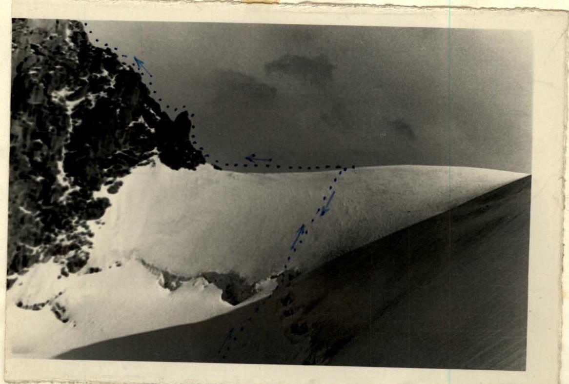
Further, the path goes along the Western ridge of the 2nd Eastern peak. At first, along a steep large scree, 300 m long, the scree leads to an ice couloir. The couloir is steep, 45°, 60 m long. We ascend the couloir with belay, cutting steps. We move to the right along the way. 3 ice screws were hammered in this section, and it took 30 minutes to pass the couloir. The couloir leads to the ridge. Further along the ridge, there are a number of small, about 2-3 m, rocky sections, which require careful belay. The rocky sections lead to an ice slope, descending to the south. The slope is limited by rocks on the left along the way. Overcoming the slope requires movement with belay. The slope is 200 m long. 10 ice screws were hammered in. Further, the ice slope turns into a snowy gentle ridge, 250 m long. The snowy slope leads to rocks. The rocks are bypassed on the right along the way, along an ice-snow couloir. We move, hammering in pitons into the rocks, which are on the left along the way. In the upper part, the couloir widens. Organize belay using ice screws. The couloir is 150 m long and has a steepness of 45°. The place is difficult. 10 pitons and 3 ice screws were hammered in. Passing the couloir took 2.5 hours in total. Having passed the couloir, we come under a large rocky trident with sheer walls. It serves as the beginning of a counterfort extending north to the 2nd Zhindy-Su glacier.
Further movement is to the right upwards along the ice slope. Steepness is 50-55°, slope length is 150 m. The place is difficult: 10 ice screws were hammered in, and it took 2 hours. The further part of the path is rocky steps with differences of 2-3 m. Here, movement is carried out with belay. The steps lead to the subpeak. From the subpeak, along easy rocks, we reach the summit. The summit is a snowy dome. On the western side, there are rocks where a cairn is built. The descent from the summit is carried out along the ascent route. Thus, the ascent to the summit took the group 16 hours. A total of 10 pitons and 36 ice screws were hammered in.
The ascent to the 2nd Eastern peak was made by a sports group of the expedition organized by the Alpinist Club of the Kir. SSR, in the following composition:
- Kolesnikov E. - 2nd sports category
- Kholodniak A. - 2nd sports category
- Tukstukbaev A. - 3rd sports category
- Veselov P. - 3rd sports category
1st Eastern — 2nd Eastern
 Choktal Massif Diagram M ≈ 1:50,000
Comments
Sign in to leave a comment