Ascent Passport
1 Ascent class — combined 2 Ascent area — Tian-Shan, Kungey Alatau ridge 3 Peak — Suvenir, height 3880 m, route — via the Northern edge from the Suvenir glacier, combined. 4 Estimated complexity category — 2A 5 Route characteristics:
- height difference — 400 m
- average steepness — 45°
- sections of 5th complexity category — none
6 Pitons driven:
- for belaying — 3, for creating I.T.O. — none
7 Overnights on the route — none
8 Number of travel hours — 5 hours
9 Group composition:
- Ganyalin V.A. — CMS — leader
- Staroselets E.V. — MS — participant
- Kholmogorov A.I. — 3rd sports rank — participant
10 Team coach —
11 Date of departure on the route and ascent — August 7, 1981
TABLE OF MAIN CHARACTERISTICS OF THE ASCENT ROUTE
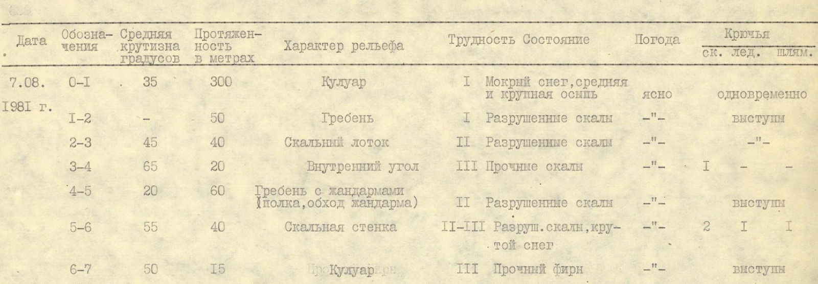
TABLE OF MAIN CHARACTERISTICS OF THE ASCENT ROUTE
| Date | Designations | Average steepness in degrees | Length in meters | Nature of terrain | Difficulty | Condition | Weather | Pitons (rock. ice. belay) |
|---|---|---|---|---|---|---|---|---|
| August 7, 1981 | R0–R1 | 35 | 300 | Couloir | 1 | Wet snow, medium and large scree | Clear | simultaneously |
| R1–R2 | 50 | Ridge | 1 | Broken rocks | — | ledges | ||
| R2–R3 | 45 | 40 | Rocky chute | 2 | Broken rocks | — | — | |
| R3–R4 | 65 | 20 | Inner corner | 3 | Solid rocks | — | 1 | |
| R4–R5 | 20 | 60 | Ridge with gendarmes (ledge, gendarme bypass) | 2 | Broken rocks | — | ledges | |
| R5–R6 | 55 | 40 | Rocky wall | 2–3 | Broken rocks, steep snow | — | 2, 1, 1 | |
| R6–R7 | 50 | 15 | Couloir | 3 | Firm névé | — | ledges |