
TO THE QUALIFICATION COMMISSION OF THE ALPINISM FEDERATION OF RUSSIA
Report
On the first ascent to the summit of Kosmos via the center of the North wall, presumably category 6B, by the team of the St. Petersburg Alpine Federation from September 26, 2021, to October 2, 2021.
I. Ascent Passport
| 1. General Information | ||
|---|---|---|
| 1.1 | Full name, sports rank of the leader | Aleksandr Borisovich Gukov, CMS |
| 1.2 | Full name, sports rank of participants | Viktor Aleksandrovich Koval, MS |
| 1.3 | Full name of coach | A.B. Gukov, V.A. Koval |
| 1.4 | Organization | St. Petersburg Alpine Federation |
| 2. Characteristics of the Ascent Object | ||
| 2.1 | Region | Central Tian Shan, Kokshaal-Too ridge |
| 2.2 | Valley | E. branch of Grigoryev Glacier |
| 2.3 | Section number according to the 2013 classification table | 7.5 |
| 2.4 | Name and height of the summit | Kosmos Peak (formerly Schmidt Peak) 5957 m by GPS |
| 2.5 | Geographic coordinates of the summit (latitude/longitude), GPS coordinates | 41°00,4378′ N 077°36,889′ E |
| 3. Characteristics of the Route | ||
| 3.1 | Name of the route | Via the center of the North wall |
| 3.2 | Proposed category of complexity | ED, WI4, 2600 m, 7 days (6B) |
| 3.3 | Degree of route exploration | First ascent |
| 3.4 | Nature of the route terrain | Combined |
| 3.5 | Elevation gain of the route (altimeter or GPS data) | 1807 m by GPS |
| 3.6 | Route length (in meters) | 2600 m |
| 3.7 | Technical elements of the route (total length of sections of varying complexity with terrain type (ice-snow, rock)) | 5 cat. cl. rock — 250 m. 3 cat. cl. ice/firn — 70 m. 4 cat. cl. ice — 500 m. 5 cat. cl. ice — 1450 m. 6 cat. cl. ice — 330 m. |
| 3.8 | Average slope of the route, (°) | 60 |
| 3.9 | Average slope of the main wall section R7–R17, (°) | 70 |
| 3.10 | Descent from the summit | Along the southeast ridge and eastern wall to Kosmos plateau, then north along the snow-ice tongue to the eastern branch of Grigoryev Glacier |
| 3.11 | Additional route characteristics | Limited number of bivouacs, hazardous lower third of the route due to icefall risk |
| 4. Characteristics of the Team's Actions | ||
| 4.1 | Time in motion (team's walking hours, in hours and days) | 41 h, 5 days |
| 4.2 | Bivouacs | 1 good bivouac, 2 ice-hollowed platforms, 1 hollowed ledge |
| 4.3 | Time spent on route processing (3) | No processing |
| 4.4 | Entry onto the route | 09/26/2021 08:30 |
| 4.5 | Summit attainment | 09/30/2021 16:50 |
| 4.6 | Return to base camp | 10/02/2021 14:00 |
| 5. Characteristics of Weather Conditions (4) | ||
| 5.1 | Temperature, °C | — |
| 5.2 | Wind speed, m/s | — |
| 5.3 | Precipitation | — |
| 5.4 | Visibility, m | — |
| 6. Responsible for the Report | ||
| 6.1 | Full name, e-mail | Aleksandr Borisovich Gukov, guuk@mail.ru |
II. Ascent Description
1. Characteristics of the Ascent Object
1.1 General Photograph of the Summit
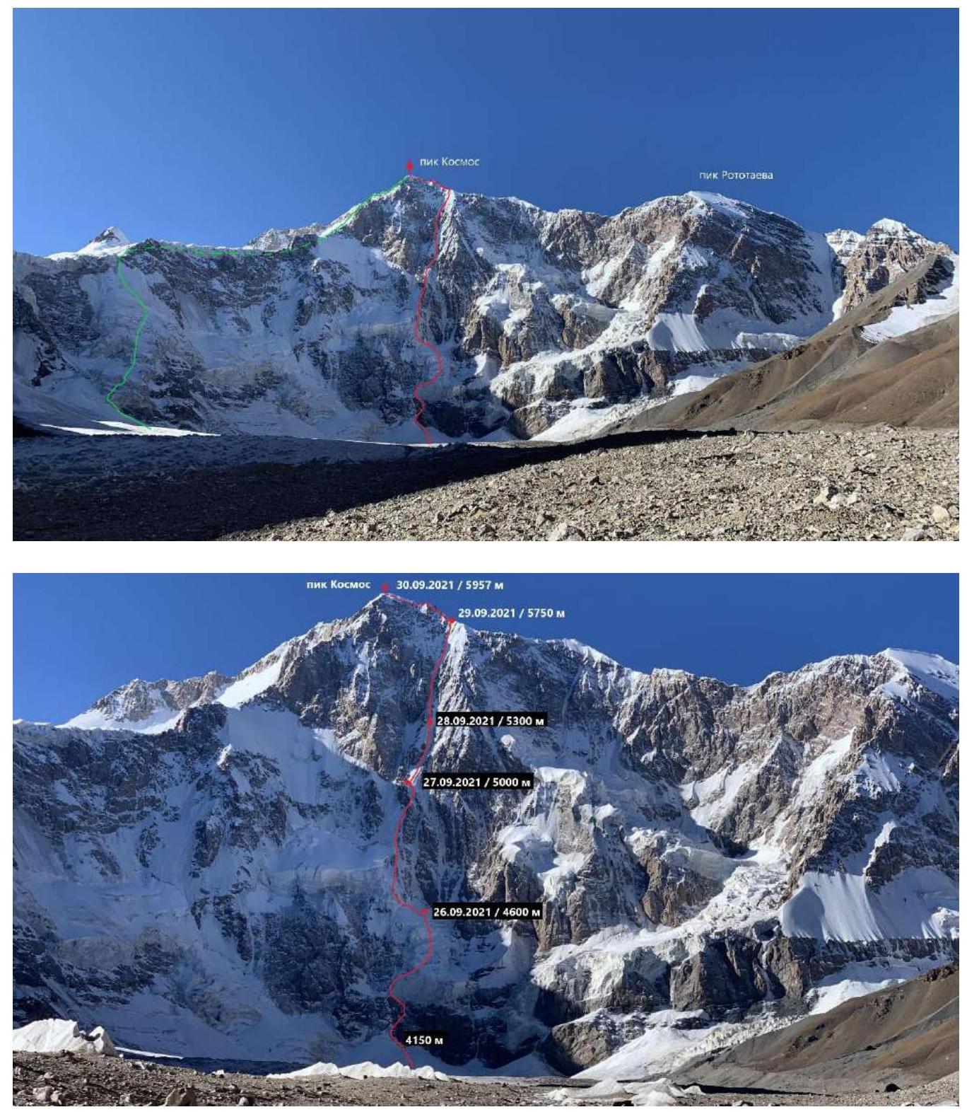
Photos taken in September 2021 from Grigoryev Glacier, E. branch. — Red line — ascent route of the St. Petersburg Alpine Federation team. — Green line — descent route of the team. No other routes to the summit of Kosmos Peak exist.
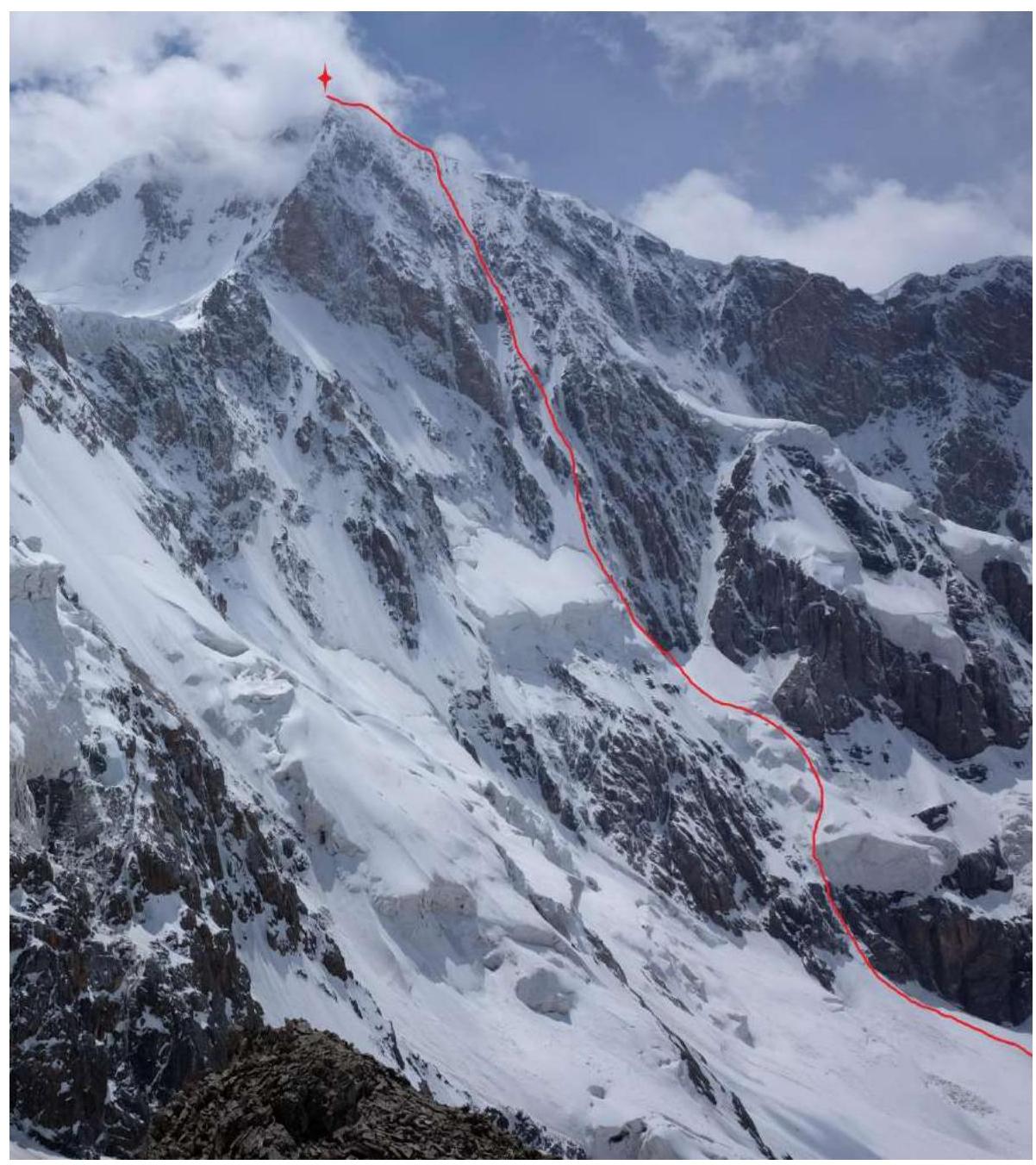
1.2 Photo of the Wall Profile
Profile of the north wall of Kosmos Peak from the west. Photo from the 2014 Polish expedition, taken from https://www.drytooling.com.pl ↗
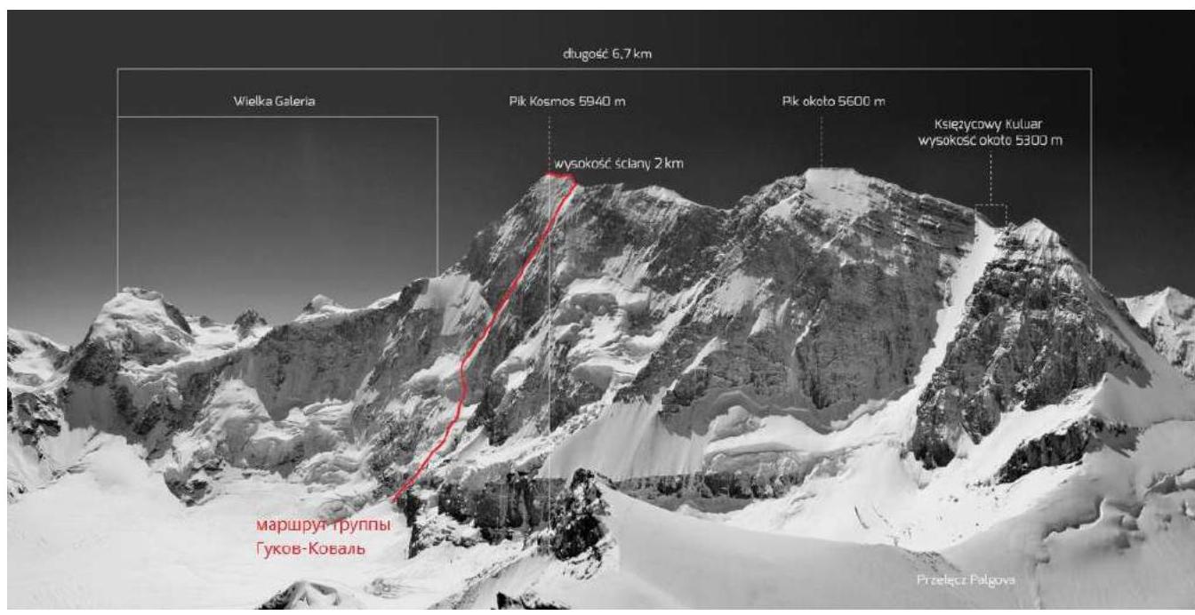
Source: Google Earth. Profile of the north wall visible on the right part of the satellite image.
1.3 Drawn Profile of the Route
1.4 Photopanorama of the Area
Taken by the St. Petersburg Alpine Federation team in September 2021.
The West Kokshaal-Too is the southernmost and highest ridge in Kyrgyzstan. It is formed by three latitudinal ridges: — Terskey Ala-Too; — Jetym; — Borkoldoy.
These ridges are located in the Central Tian Shan between Lake Issyk-Kul and the Taklamakan Desert. The highest section of the ridge, 70 km long, is between the through valleys of the Kakshaal River to the south and the Uzenigush and Mudyur rivers to the north, which cut through the ridge and carry their waters into the Tarim basin.
This area has many peaks above 6000 m. The most interesting among them: — Kyzyl-Asker Peak (5842 m); — Krylya Sovetov Peak (5800 m); — Kosmos Peak (5957 m); — Dankova Peak (5982 m); — Chon-Turasy or Joldash Peak (5729 m); — Alpinist Peak (5641 m); — Sergei Korolev Peak (5816 m).
The area is characterized by a combination of alpine forms (many vertical rock walls with a height difference of about 1.5–2 km) with extensive glaciation, second only to the area around Peak Pobeda in Tian Shan. The Ak-Sai glaciation node (153 glaciers with a total area of 443 km²) is one of the largest in Tian Shan.
The entire area, including the lowlands, is a zone of permafrost. The terrain is heavily waterlogged.
The snow line is at an altitude of about 4000–4500 m above sea level. The river valleys have a relatively high absolute height of about 3000–3500 m above sea level.
The climate in the valley is harsh. The average monthly temperature in summer is around −5–8 °C, with unstable weather. According to our observations and information from local specialists, the best time of year with stable weather is September–October and January–February.
This area is rarely visited by people. The West Kokshaal-Too can still be called a "white spot" on the map. For modern expeditions, visiting this area is an excellent opportunity not only to find new alpine routes but also to conquer new peaks that have not been trodden by human foot. And that's what we did.
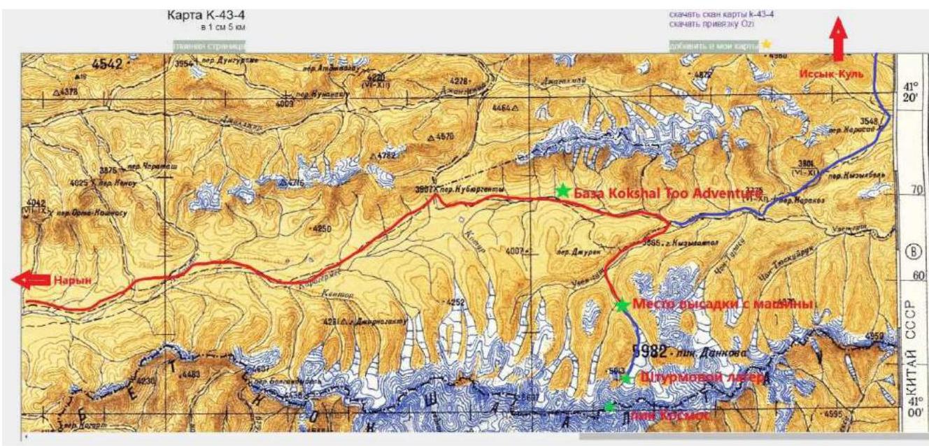
There are two roads to the Kosmos Peak area from Bishkek: — the first goes through the southern shore of Lake Issyk-Kul; — the second — through the town of Naryn and the Kyzyl-Asker area.
In the winter of 2020, we traveled along the first road, and this time — along the second, through Naryn. It's better to organize the trip through the Kokshaaltoo Adventure company, which has two bases in the area: — one opposite Kyzyl-Asker Peak; — the second opposite Dankov and Kosmos Peaks.
The journey from Bishkek to the Kokshaaltoo Adventure base via Naryn takes a day under favorable weather conditions. From the base, you can drive to the Dan'kova meadow at the foot of the western branch of Grigoryev Glacier in another 4–5 hours by car (4WD). If the rivers are swollen, horseback delivery is possible through a pass.
From the Dan'kova meadow to the assault camp under the wall of Kosmos Peak, the journey takes about 12 km along Grigoryev Glacier between Dankov Peak and Chernogolovka Peak.
The glacier is passable in the center, to the right of the river downstream. From the assault camp to the start of the route under the wall, it's another 1.5 km.
The wall of Kosmos Peak closes the valley with a massive width of several kilometers. There are several hanging glaciers on the wall, from which icefalls constantly occur. This must be taken into account when planning the location of the base camp, which should be situated at a significant distance from the wall.
History of Attempts to Ascend Kosmos Peak
In 1972, a team of climbers from Kazakhstan (G. Gulnev, A. Ilyinsky, R. Kuramshin, V. Mikhin, Yu. Mitrokhin) attempted to traverse the Kosmos Peak massif from east to west via Peak 5642. Although the team did not reach the summit and the ascent was aborted, erroneous information about a supposedly existing 5B category route appeared in the FAR archives.
According to our information, after reaching the first summit of the traverse of Peak 5642, the team stopped the ascent and descended (confirmed by participant Viktor Mikhin).
In 1980–1989, the area was not visited. Meanwhile, foreign publications contained erroneous information about an ascent to this peak in the 1980s via a 5B route (referring to G. Gulnev's team's attempt).
Climbers returned to this area in the mid-1990s. In 1995, a team led by A. Chkhetiiani ascended Rotoataev Peak — a summit in the Kosmos massif ridge, 2 km west of the main summit, but due to weather conditions, they abandoned the attempt to reach Kosmos Peak.
In 1998, climbers from the "Chernogolovka" club (Moscow and Moscow region) attempted to ascend the north wall of Kosmos Peak, resulting in the death of the team leader, Igor Korsun.
In 2014, a Polish team ascended a snow-ice couloir to a saddle to the right (west) of Rotoataev Peak without reaching its summit.
In 2019, a tourist group led by Ilya Mikhalev ascended from Kosmos Plateau along the eastern ridge to an altitude of about 5800 m.
Thus, on the last day of September 2021, we were fortunate enough to become the first climbers to set foot on the summit of Kosmos Peak.
2. Characteristics of the Route
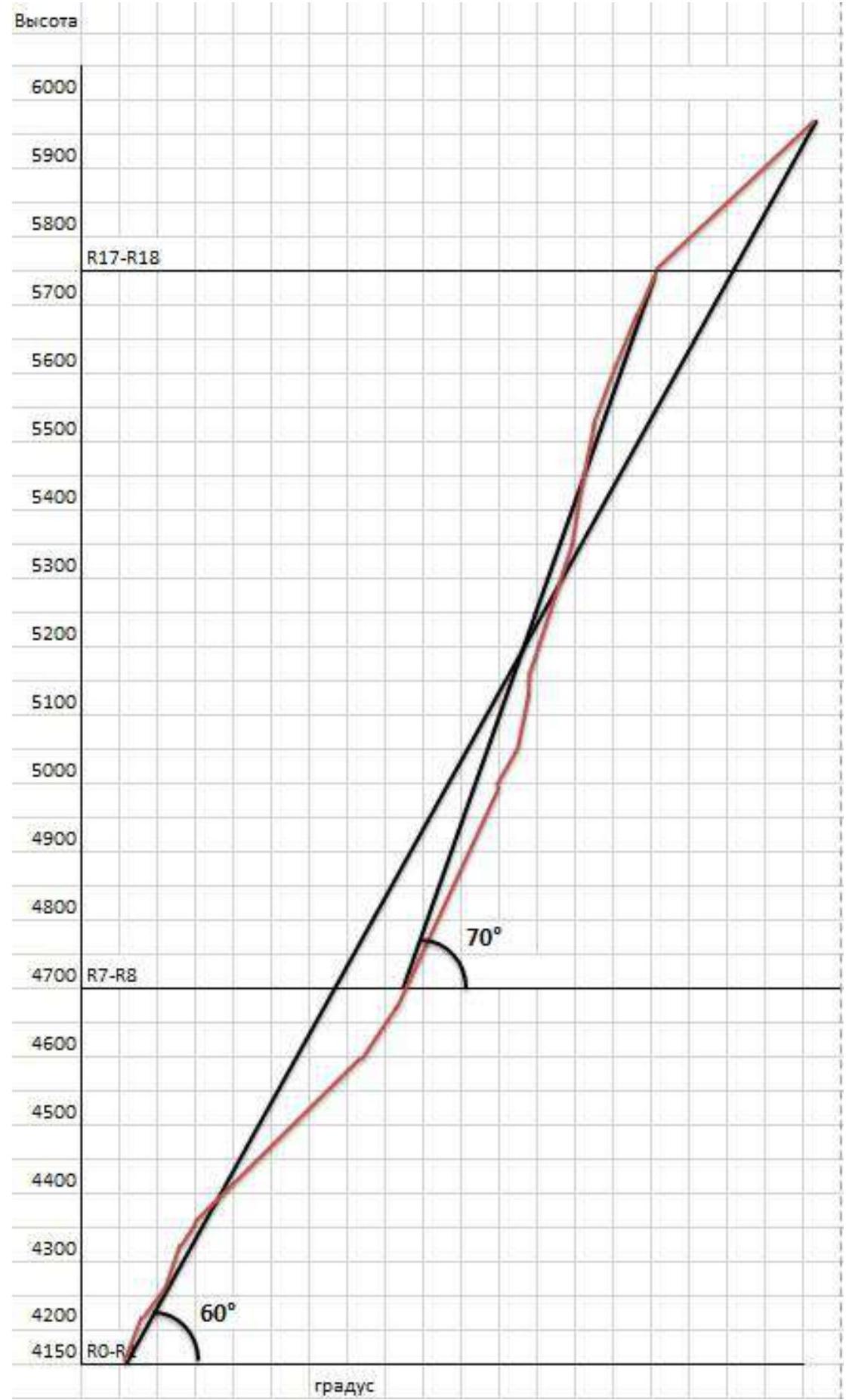
2.1 Technical Photograph of the Route
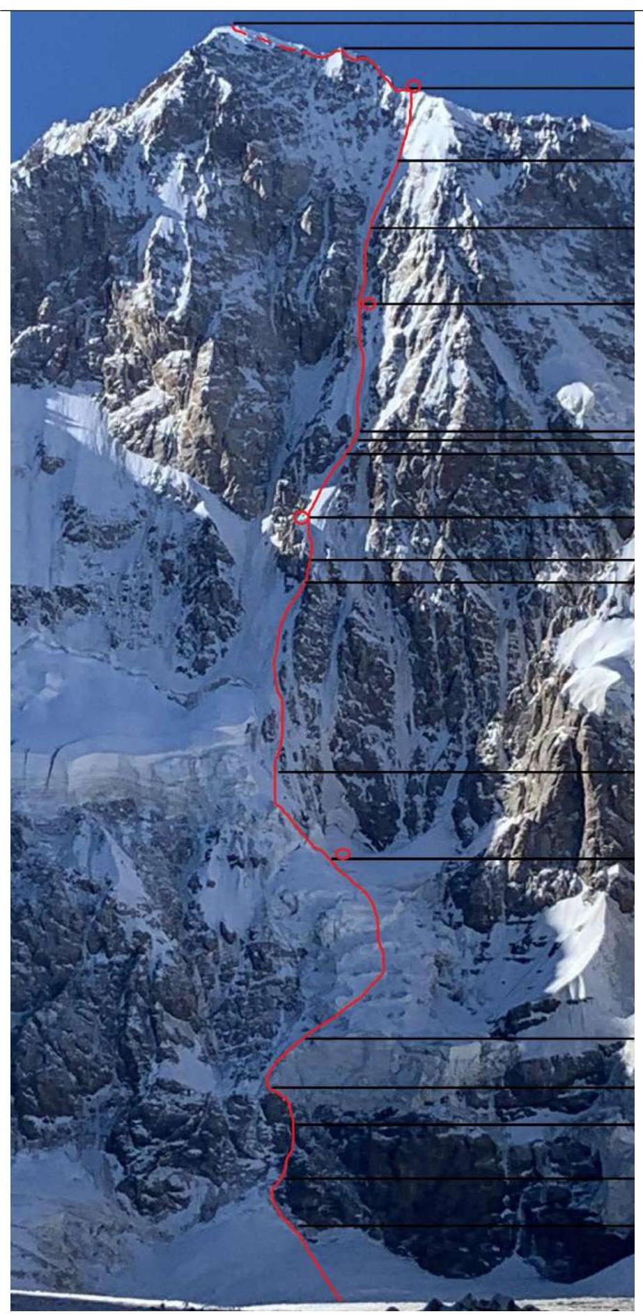
Summit 5957 m, September 30, 2021. — R17–R18 rappel, snow-ice slope — R16–R17 rock ridge
Bivouac 5750 m, September 29, 2021. — R15–R16 snow-ice slope, 60°
— R14–R15 ice slope, 65° — R13–R14 ice "river," 80–75°
Bivouac 5300 m, September 28, 2021. — R12–R13 ice slope, 70° — R11–R12 ice wall, 100° — R10–R11 ice slope, 70° — R9–R10 ice slope, 60°
Bivouac 5000 m, September 27, 2021. — R8–R9 ice slope, 65° — R7–R8 ice saddle, 75°
— R6–R7 ice slope, 65° — R5–R6 second ice barrier, 55°
Bivouac 4600 m, September 26, 2021. — R4–R5 first ice barrier, average slope 50°
— R3–R4 ice wall, 70° — R2–R3 ice wall, 75° — R1–R2 ledges and internal corner, filled with ice, 65°
— R0–R1 ice wall along the rock boundary, 75°, height 4150 m
2.2 Route Diagram in UIAA Symbols
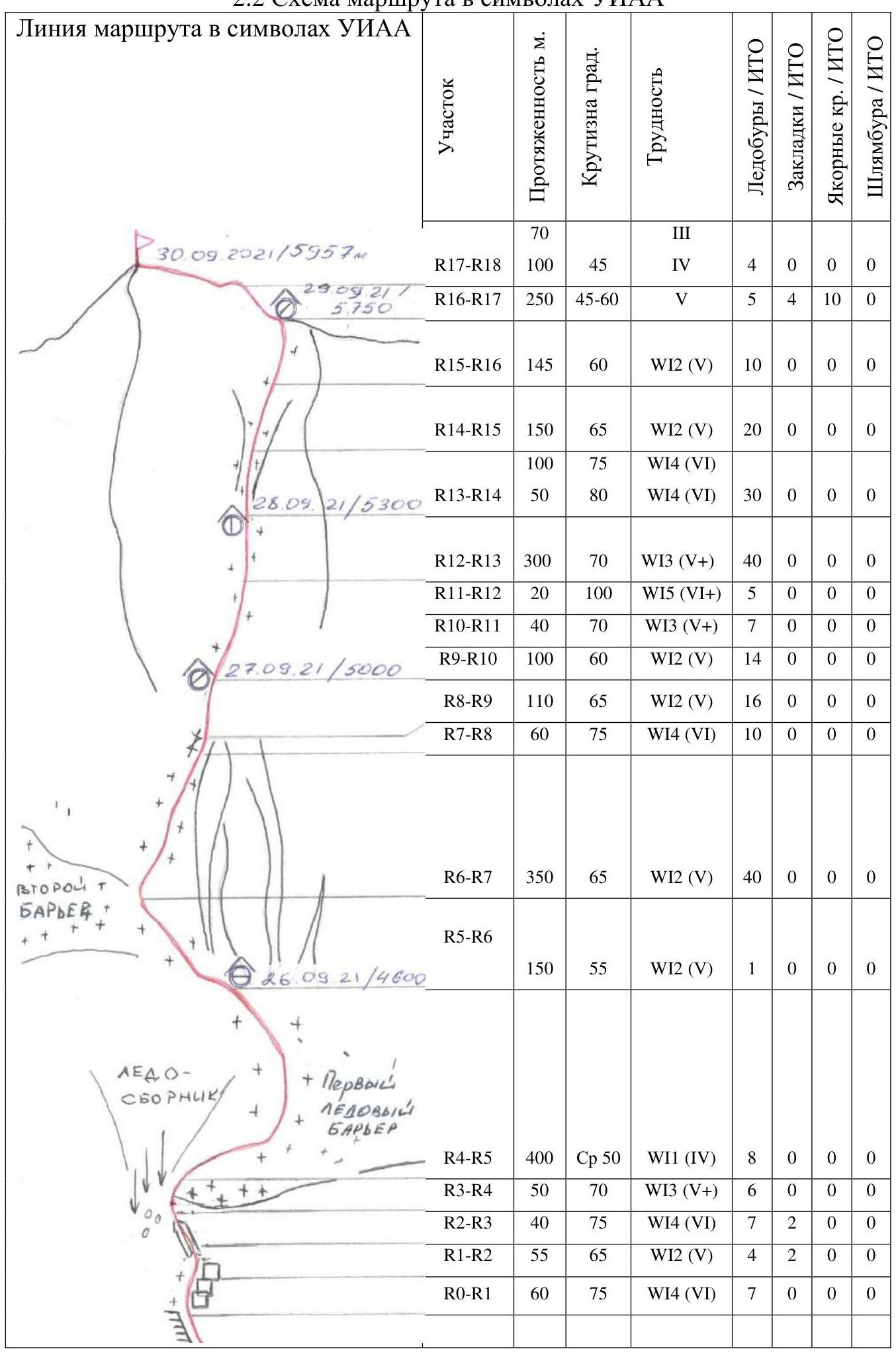
| Section | Length, m | Slope, ° | Difficulty | Ice screws / ITO | Pitons / ITO | Anchor hooks / ITO | Bolts / ITO |
|---|---|---|---|---|---|---|---|
| R17–R18 | 100 | 45 | 4 | 4 | 0 | 0 | 0 |
| R16–R17 | 250 | 45–60 | 5 | 5 | 4 | 10 | 0 |
| R15–R16 | 145 | 60 | WI2 (5) | 10 | 0 | 0 | 0 |
| R14–R15 | 150 | 65 | WI2 (5) | 20 | 0 | 0 | 0 |
| R13–R14 | 100 | 75 | WI4 (6) | ||||
| 50 | 80 | WI4 (6) | 30 | 0 | 0 | 0 | |
| R12–R13 | 300 | 70 | WI3 (5+) | 40 | 0 | 0 | 0 |
| R11–R12 | 20 | 100 | WI5 (6+) | 5 | 0 | 0 | 0 |
| R10–R11 | 40 | 70 | WI3 (5+) | 7 | 0 | 0 | 0 |
| R9–R10 | 100 | 60 | WI2 (5) | 14 | 0 | 0 | 0 |
| R8–R9 | 110 | 65 | WI2 (5) | 16 | 0 | 0 | 0 |
| R7–R8 | 60 | 75 | WI4 (6) | 10 | 0 | 0 | 0 |
| R6–R7 | 350 | 65 | WI2 (5) | 40 | 0 | 0 | 0 |
| R5–R6 | 150 | 55 | WI2 (5) | 1 | 0 | 0 | 0 |
| R4–R5 | 400 | 50 | WI1 (4) | 8 | 0 | 0 | 0 |
| R3–R4 | 50 | 70 | WI3 (5+) | 6 | 0 | 0 | 0 |
| R2–R3 | 40 | 75 | WI4 (6) | 7 | 2 | 0 | 0 |
| R1–R2 | 55 | 65 | WI2 (5) | 4 | 2 | 0 | 0 |
| R0–R1 | 60 | 75 | WI4 (6) | 7 | 0 | 0 | 0 |
3. Characteristics of the Team's Actions
3.1 Brief Description of the Route Passage
| Section | R16–R17 (rock ridge) | | | The beginning of the section passes through the heavily destroyed lower part of the second ice barrier along the rock wall with an exit through a narrow saddle to its upper part. Movement is simultaneous, the possibility of effective belaying is absent (firn) despite the length of the section and its steepness. The risk of icefalls is very high up to the approach to the ice wall. Length 150 m, slope 55°, 5 cat. cl. | 6 | | R6–R7 | The end of the hazardous part of the route. A prolonged ice section in the direction of a narrow rock saddle filled with ice. Length 350 m, slope 65°, 5 cat. cl. | 7–8–9 | | R7–R8 | A rock saddle filled with ice, reliable belay. Transition to the right and up to the adjacent ice wall. Length 60 m, slope 75°, 6 cat. cl. | 10 | | R8–R9 | An ice wall ending in a steep ice ridge, on which a small (half a tent) ledge can be hacked out in two hours. Bivouac is safe but uncomfortable. There are no other places for bivouacs. Height 5000 m, length 110 m, slope 65°, 5 cat. cl. | 11 | | R9–R10 | Movement along the ice ridge, transitioning into a steep ice wall towards an overhanging ice wall. Length 100 m, slope 60°, 5 cat. cl. | 12 | | R10–R11 | Approach along the ice to the overhanging ice wall. Length 40 m, slope 70°, 5+ cat. cl. | 13 | | R11–R12 | An overhanging ice wall, climbing is extremely difficult, requiring skills in ice climbing. Length 20 m, slope 100°, 6+ cat. cl. | 14 | | R12–R13 | A prolonged steep steep ice wall, eventually becoming a narrow ice couloir. Further, up to the summit ridge, there are no places for bivouacs. Despite the steepness of the slope (70°), we decide to organize a bivouac here under the protection of overhanging rocks. Two hours of work allow us to hack out a ledge wide enough for half a tent. Sitting bivouac. At night, due to increasing wind in the upper part of the wall, continuous micro-avalanches began, significantly disturbing rest. Height 5300 m. Length 300 m, slope 70°, 5+ cat. cl. | 15 | | R13–R14 | An ice couloir gradually widening upwards. Length 50 m, slope 80°, 6 cat. cl. — 100 m, slope 75°, 6 cat. cl. | 16 | | R14–R15 | An ice wall. Contrary to expectations, the steepness of the ice wall decreases insignificantly. We continue moving upwards towards the summit ridge. Length 150 m, slope 65°, 5 cat. cl. | 17 | | R15–R16 | A snow-ice section leading to the eastern ridge of Kosmos Peak. Under the snow, partially destroyed rocks. The ridge turned out to be sharp, no bivouac sites were visible, a strong south wind arose, and we had to hack out a platform in the ice again. Bivouac is uncomfortable. The night was tense, the wind reached hurricane force. But the tent held! Length 145 m, slope 60°, 5 cat. cl. | 18 | | R16–R17 | A sharp, destroyed rock ridge with gendarmes, many loose stones, belay is extremely unreliable. In the middle part of the section, we had to traverse to the north wall and move left-up along the wall, bypassing the gendarmes of the summit ridge below on the rocks (about 120 m). Belaying here is possible only on anchor hooks, which were simply pulled out by hand by the second participant due to the rock's characteristics (resembling tiles on an old roof). Further, we return to the ridge, and at the end of the section, a twenty-meter rappel onto a snow saddle. Psychologically very difficult section. Length 250 m, slope 45–60°, 5 cat. cl. | 19–20 | | R17–R18 | A snow-ice summit tower, the section is traversed from the south side. Belay on ice screws. Summit 5957 m by GPS. Length 170 m, slope 45°, 4–3 cat. cl. | 21 |
Photos of Route Sections
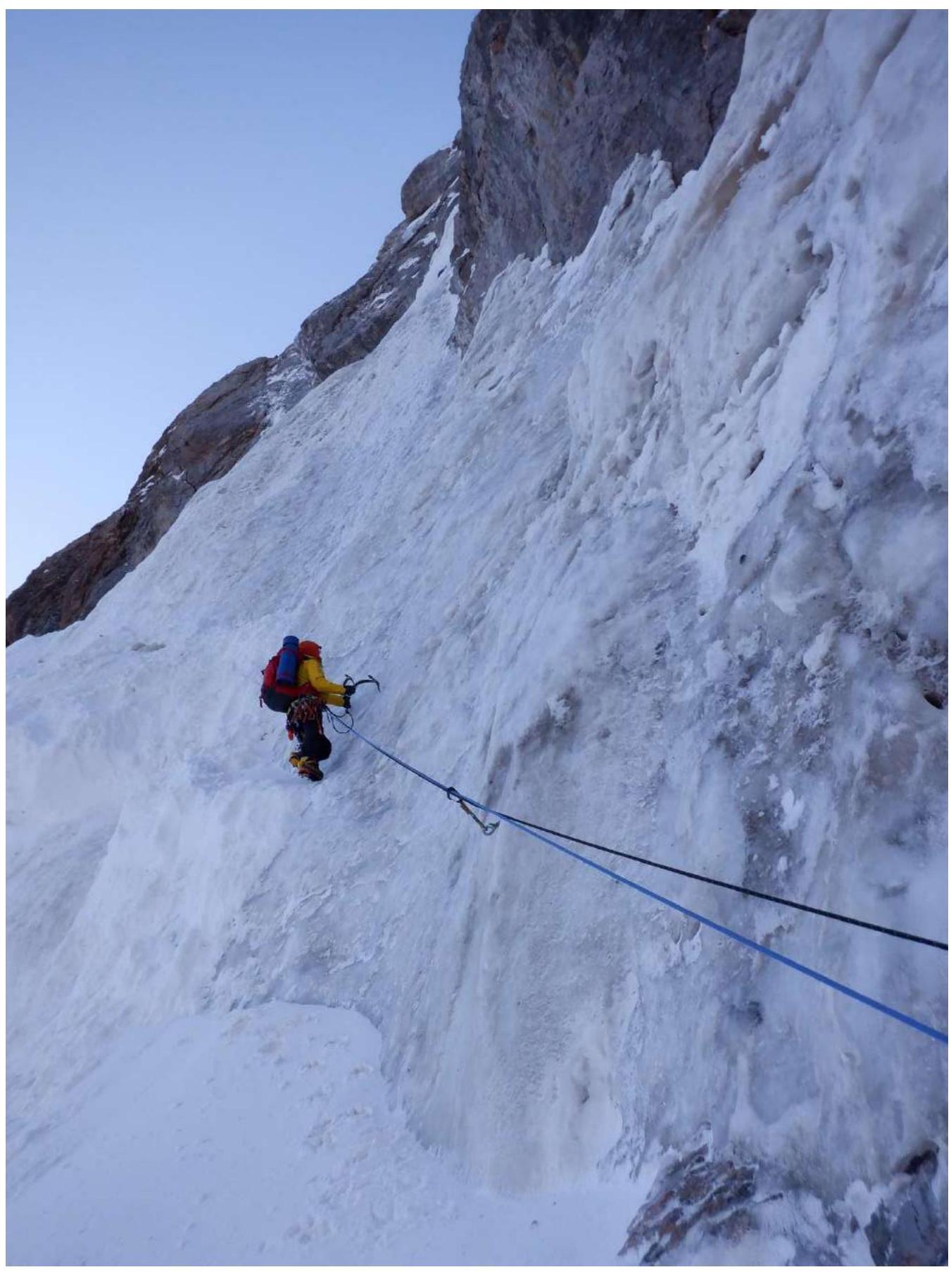
Photo 1. Section R0–R1
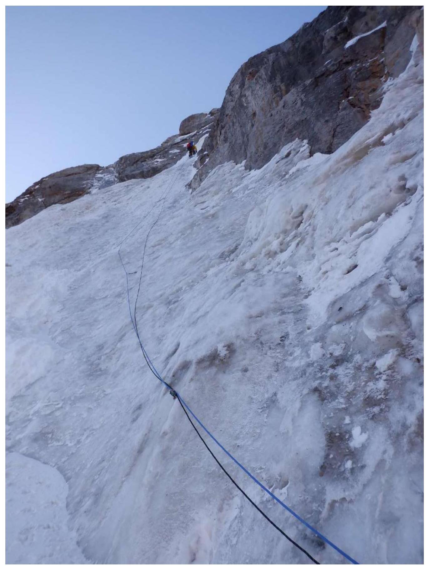
Photo 2. Section R0–R1
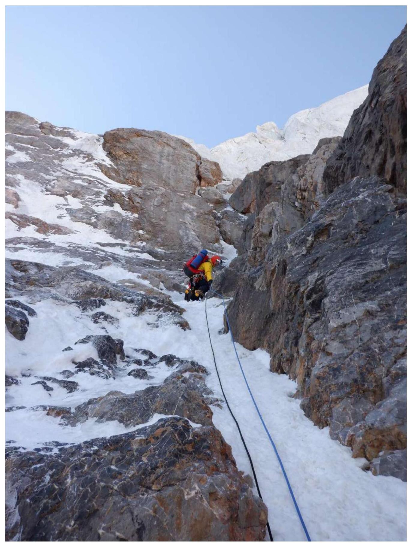
Photo 3. Section R1–R2
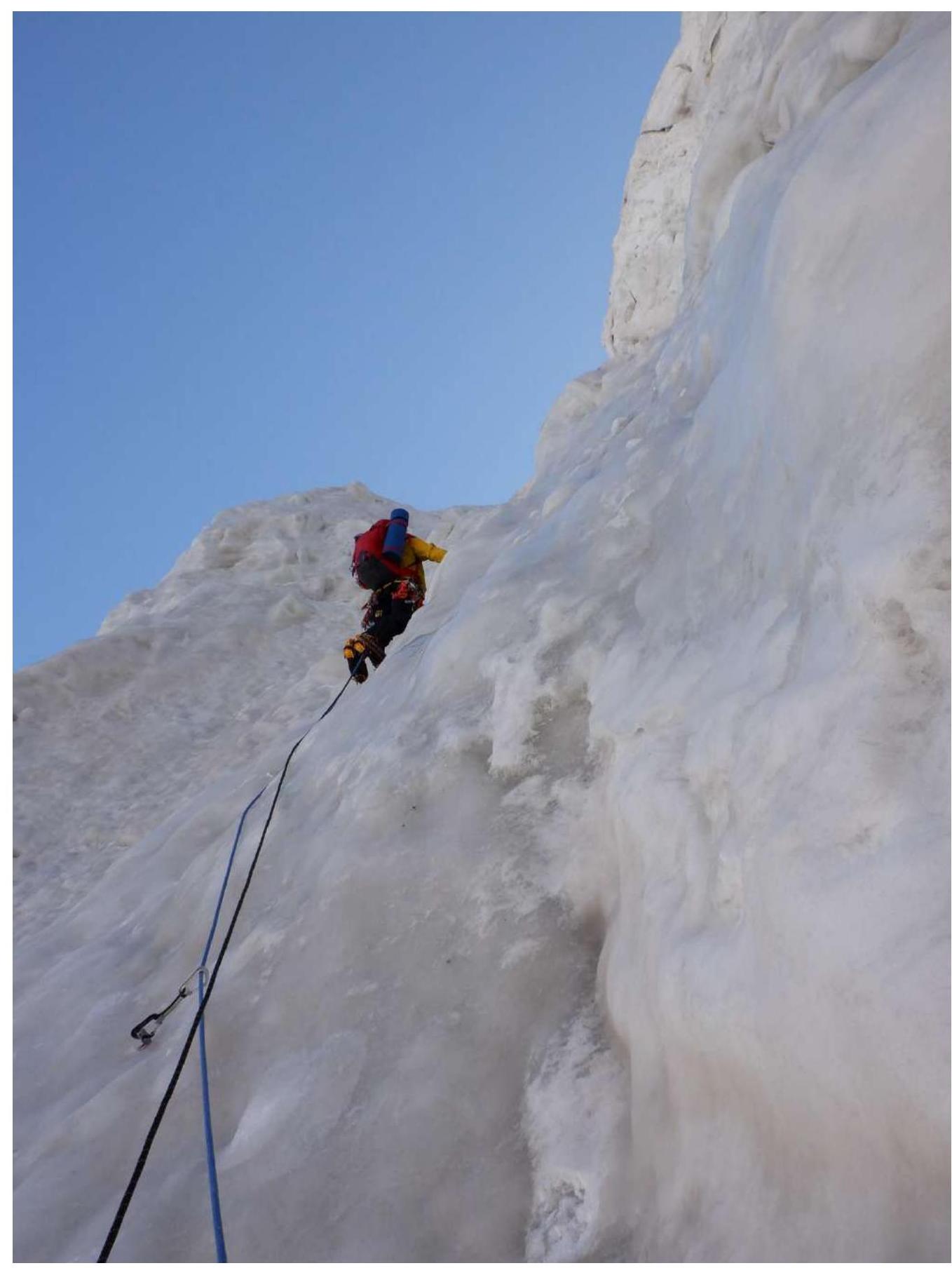
Photo 4. Section R2–R3
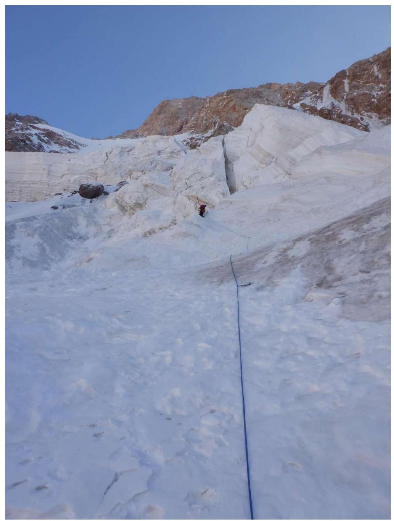
Photo 5. Section R4–R5
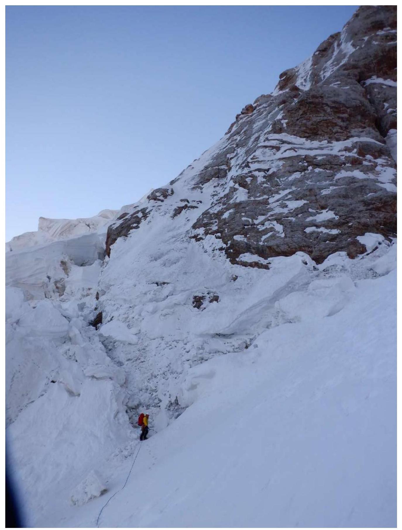
Photo 6. Section R5–R6
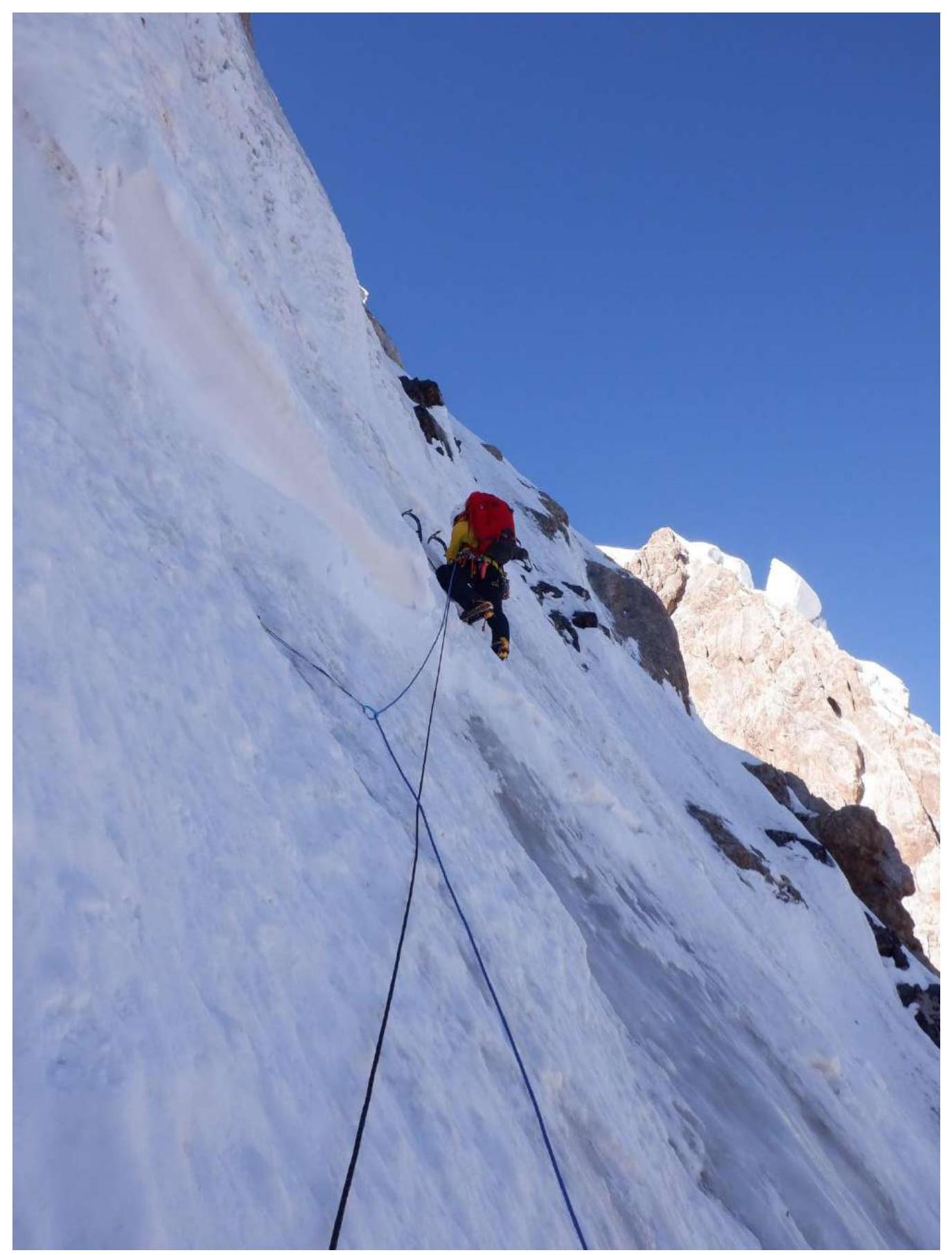
Photo 7. Section R6–R7
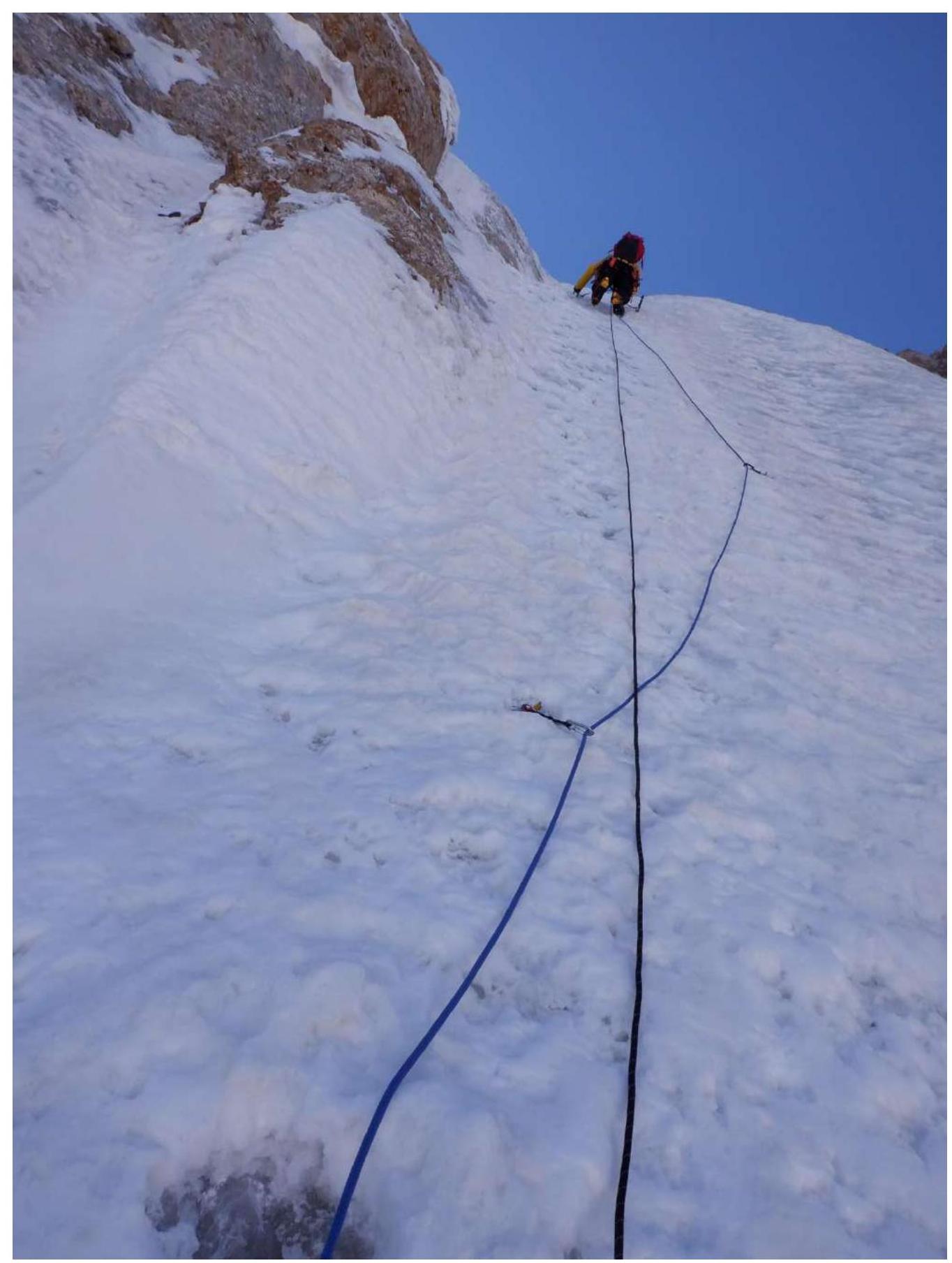
Photo 8. Section R6–R7
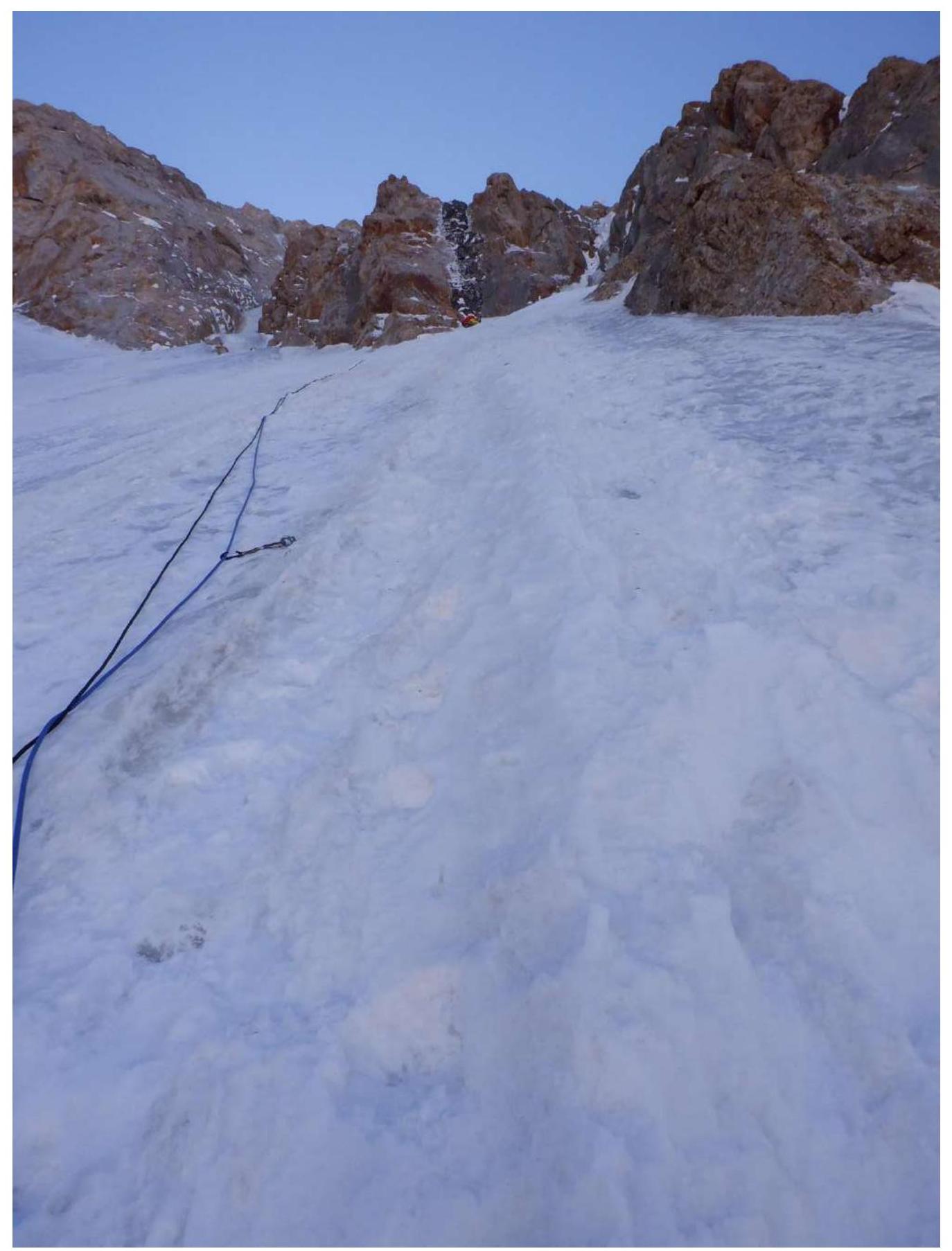
Photo 9. Section R6–R7
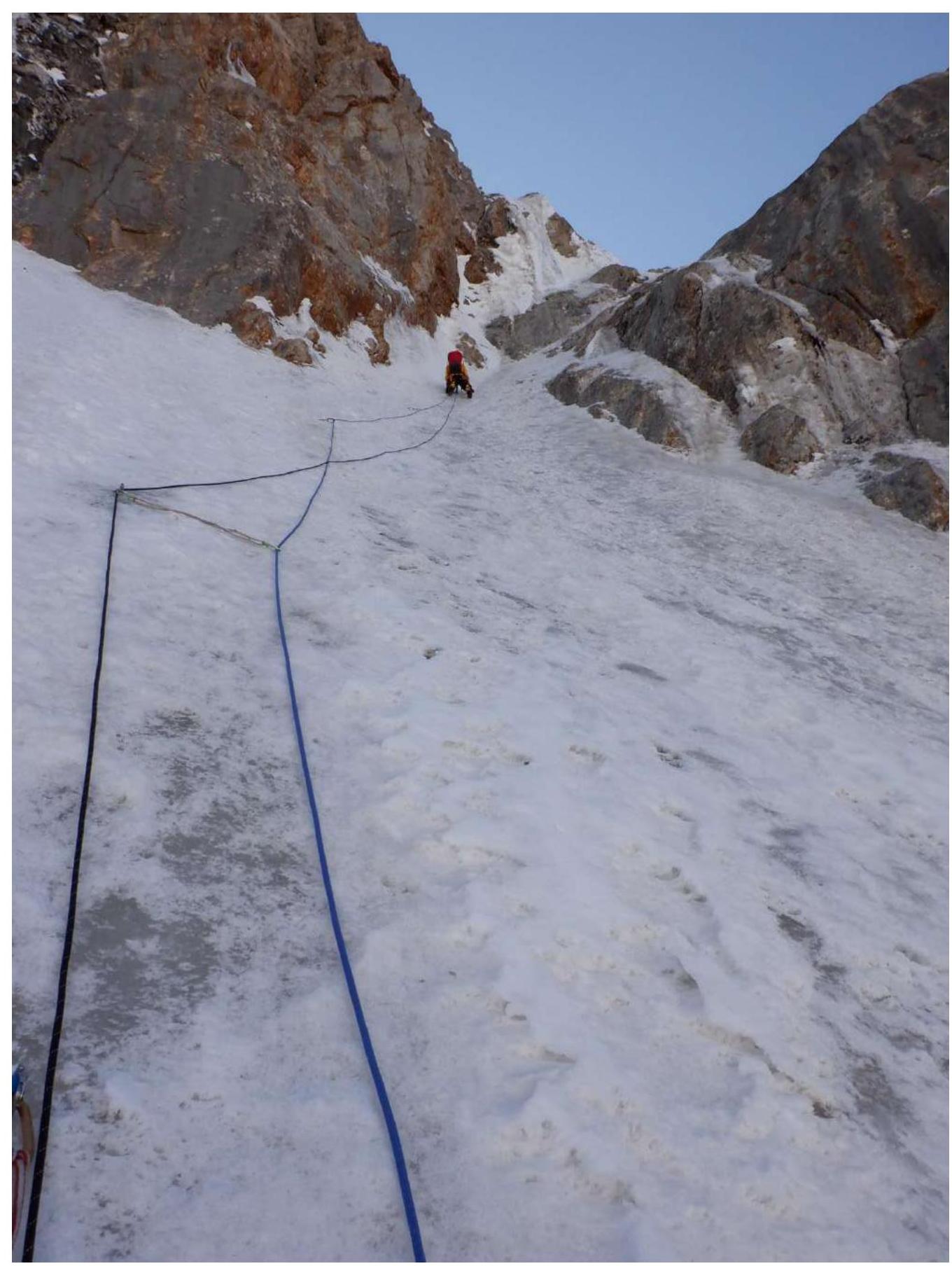
Photo 10. Section R7–R8
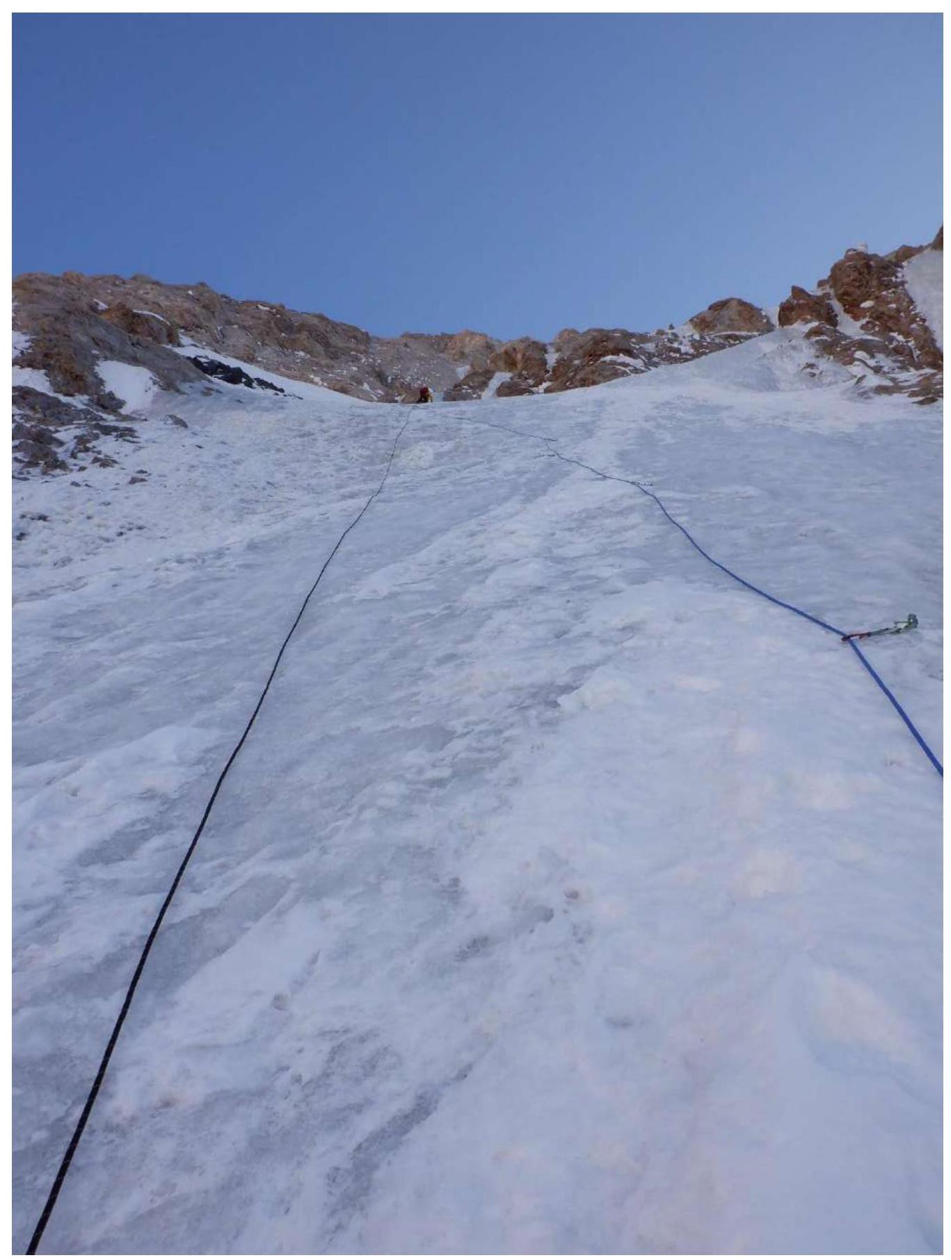
Photo 11. Section R8–R9
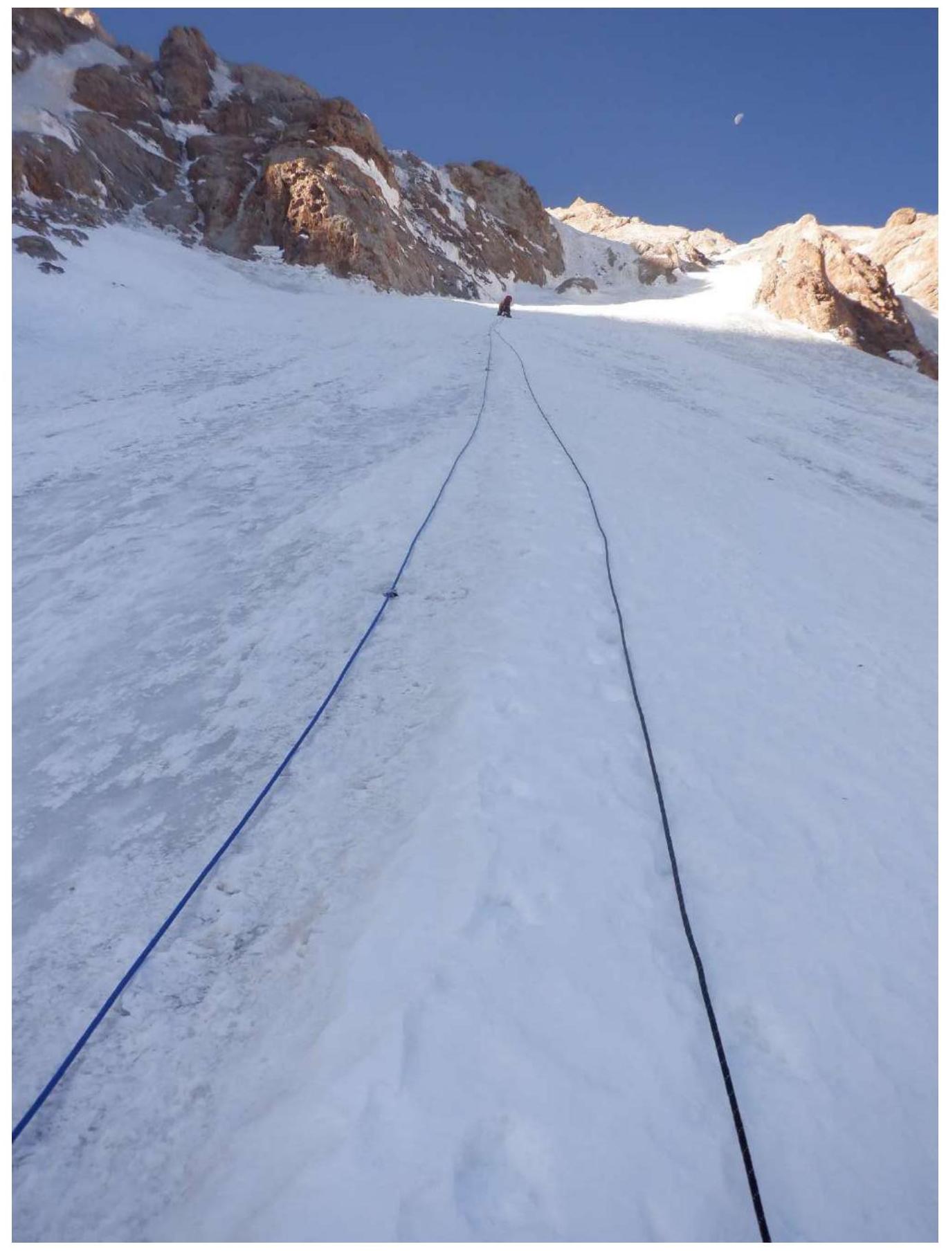
Photo 12. Section R9–R10
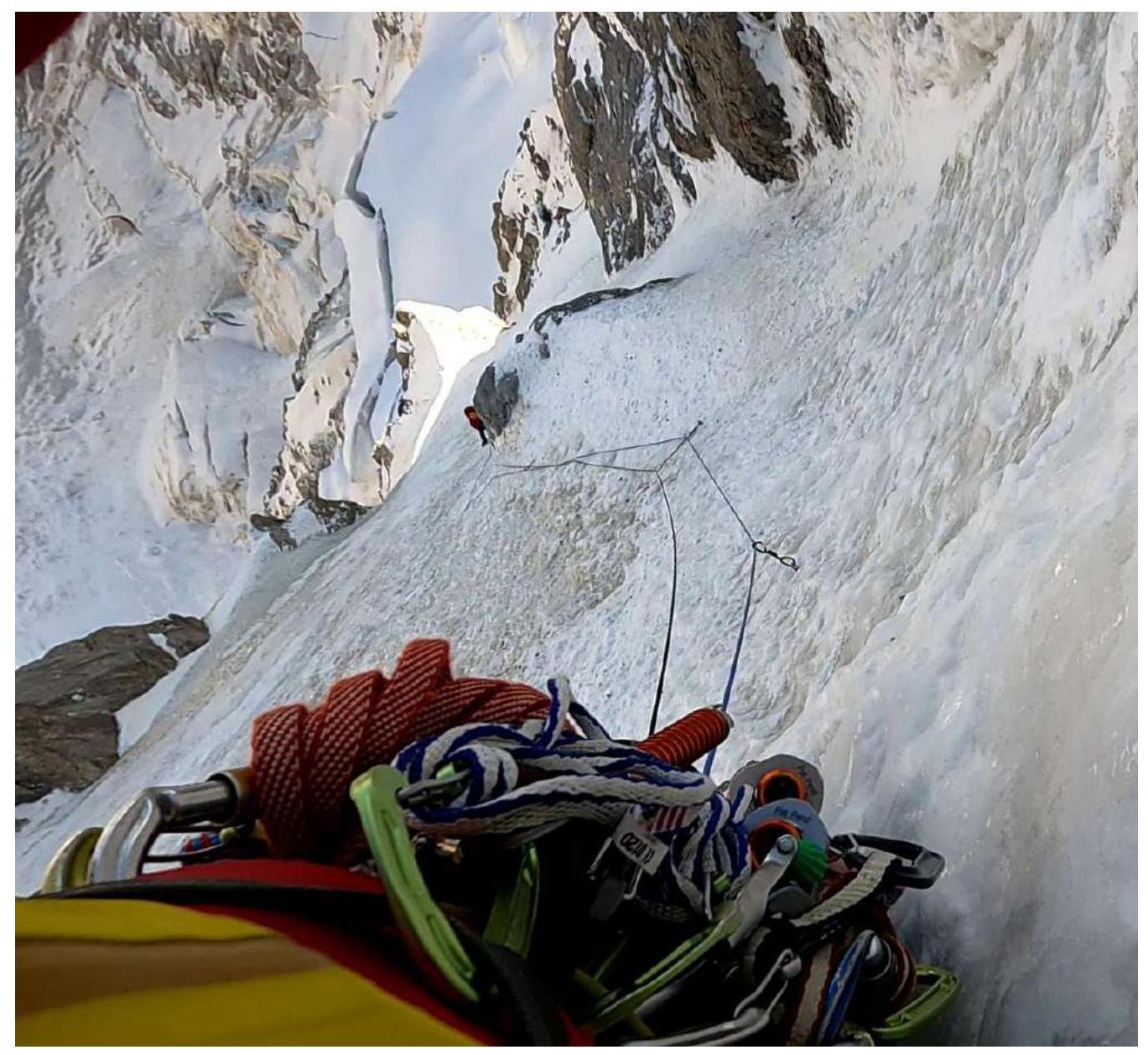
Photo 13. Section R10–R11
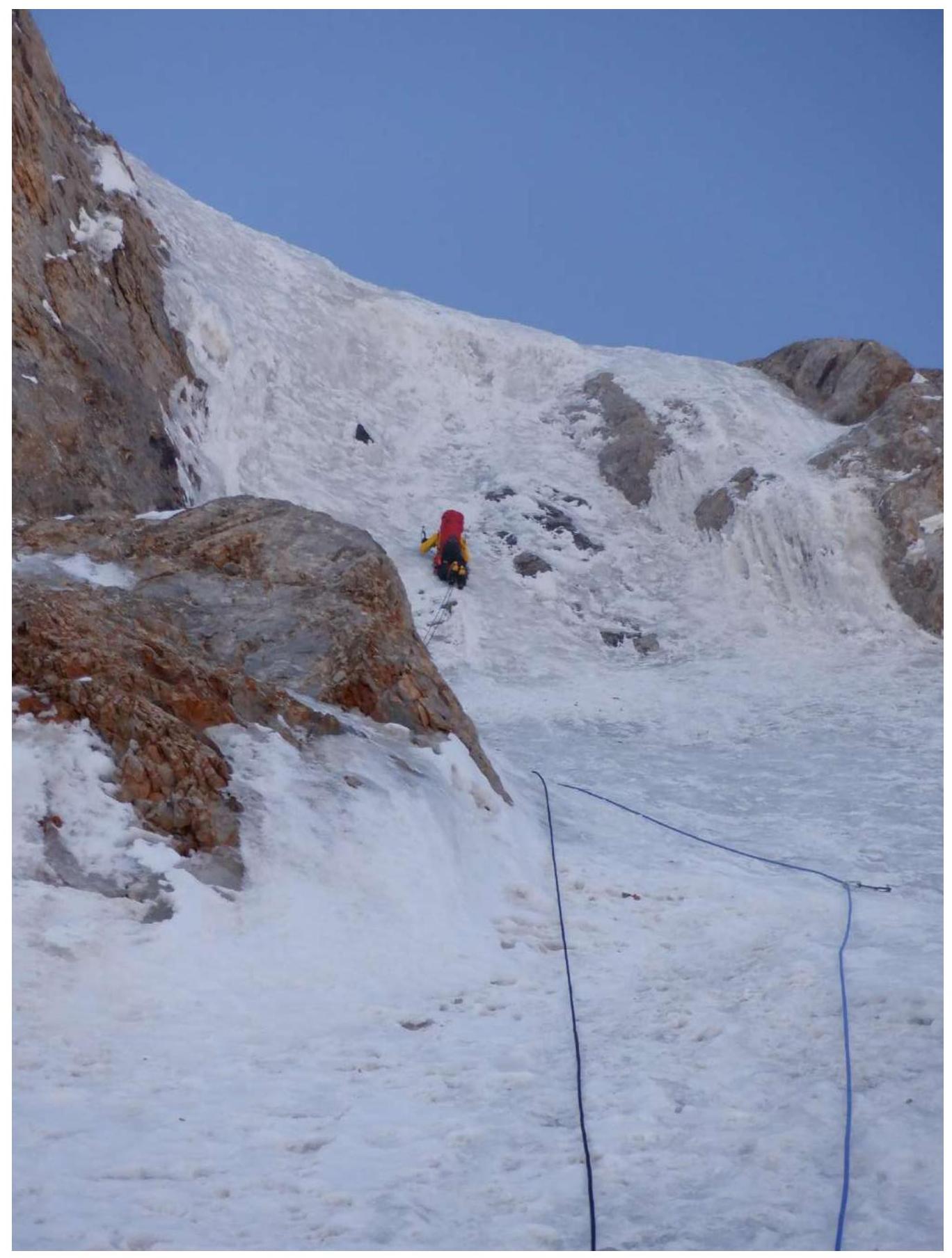
Photo 14. Section R11–R12
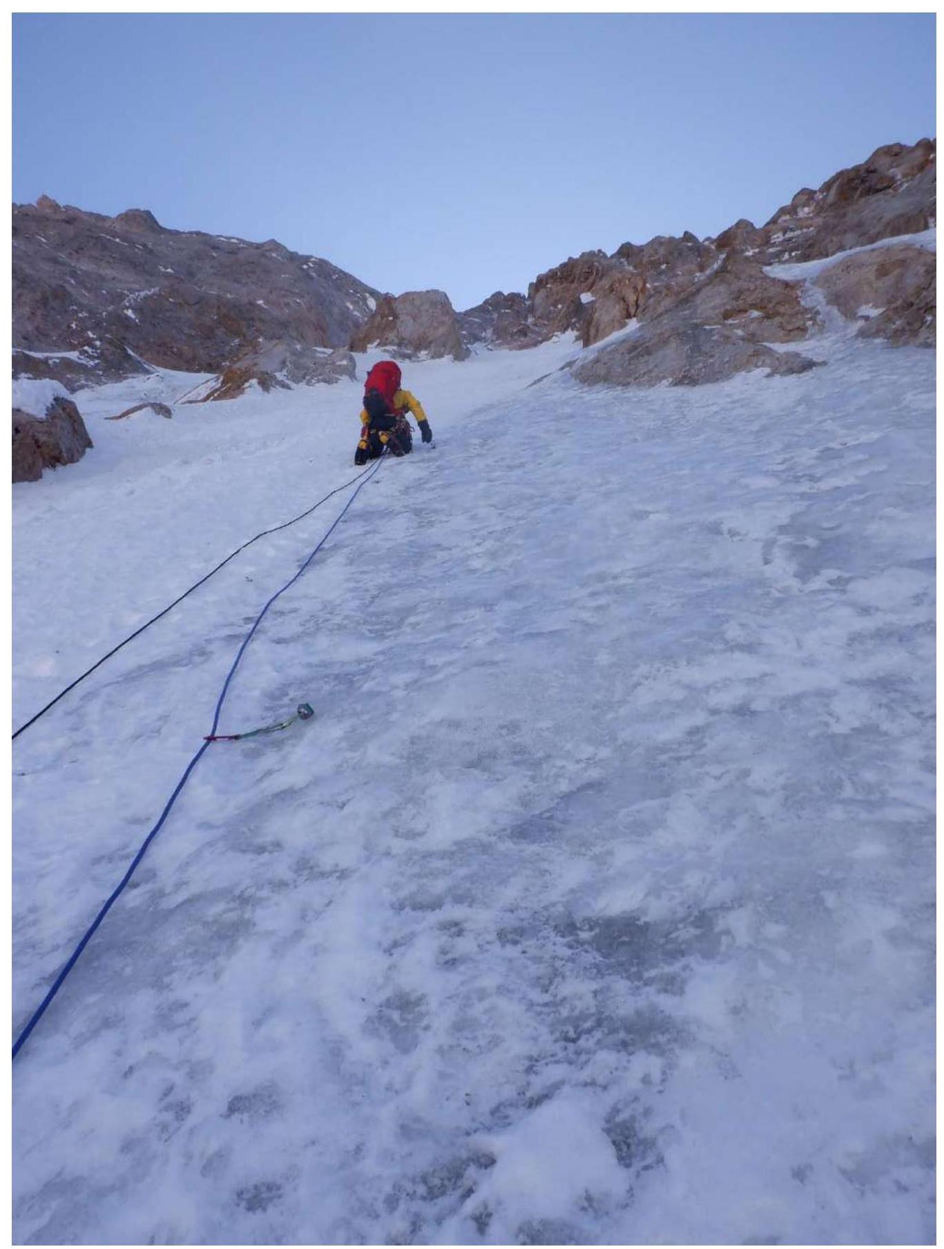
Photo 15. Section R12–R13
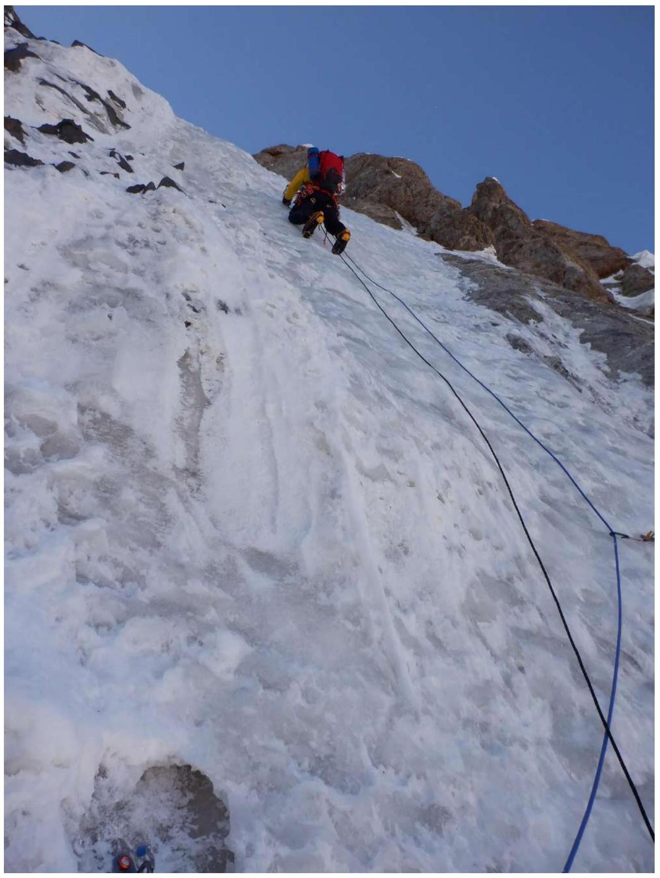
Photo 16. Section R13–R14
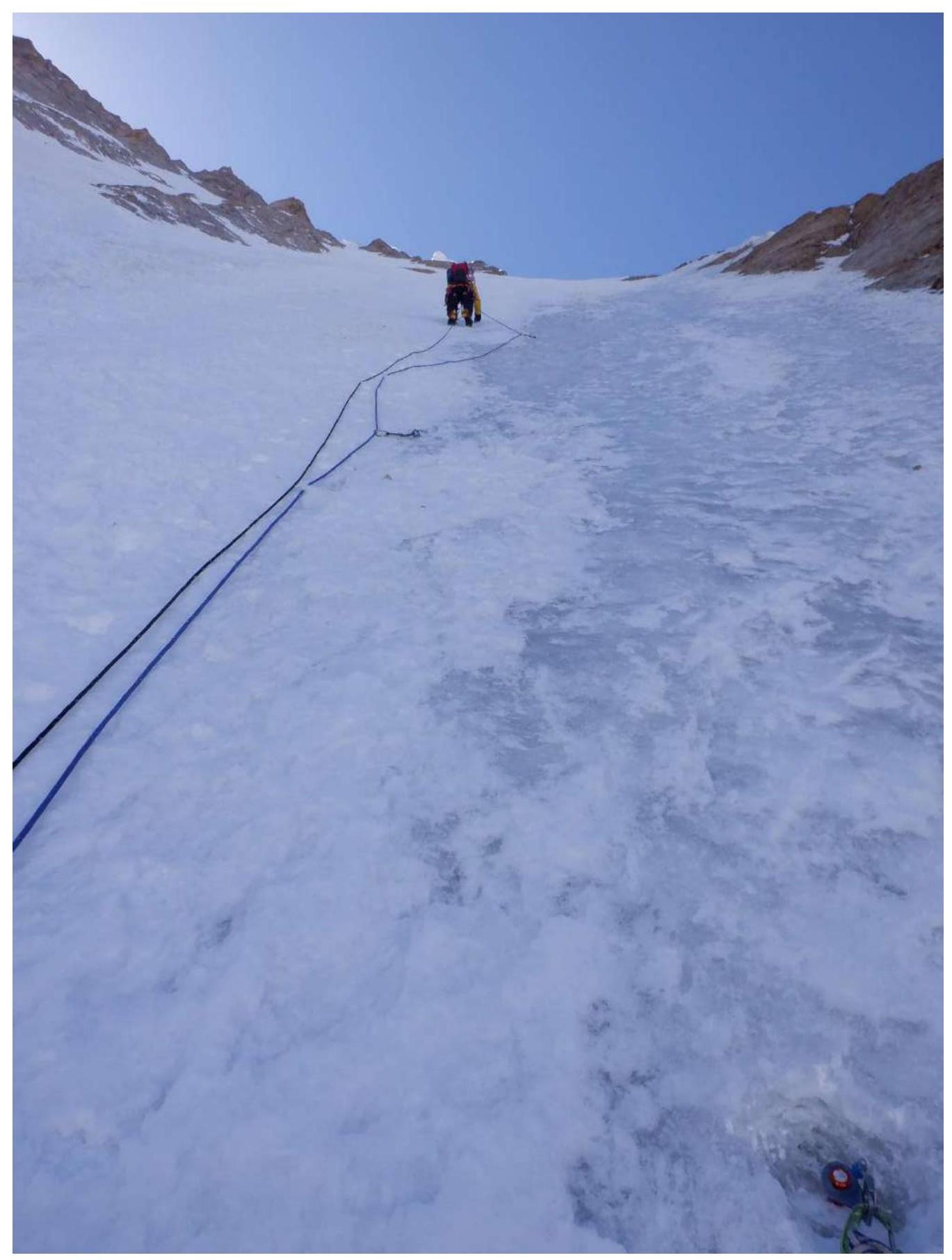
Photo 17. Section R14–R15
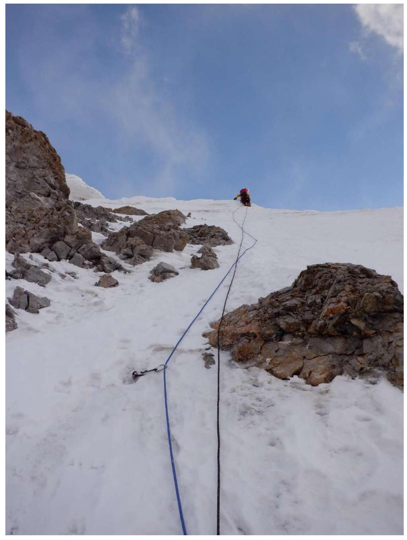
Photo 18. Section R15–R16
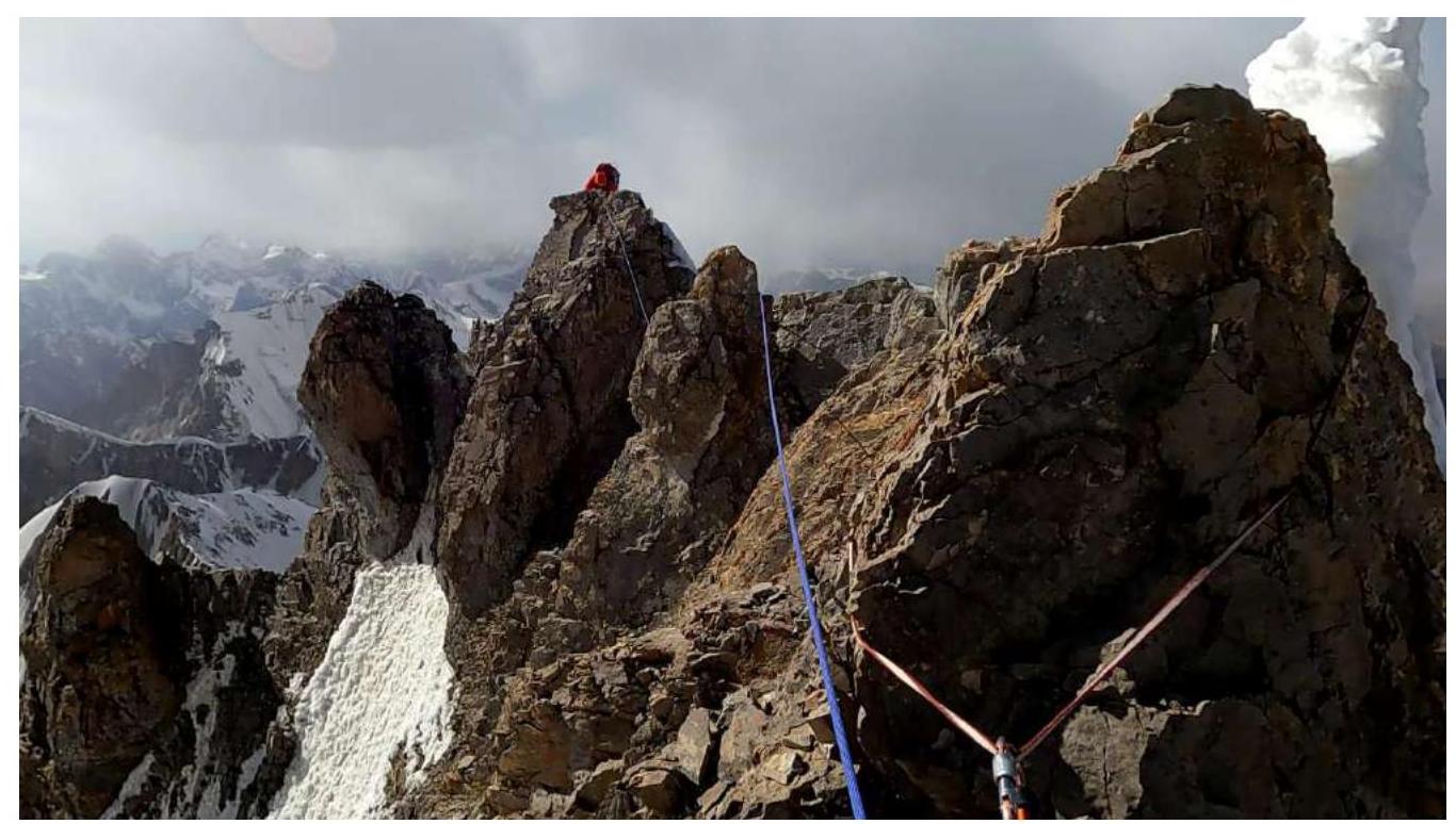
Photo 19. Section R16–R17
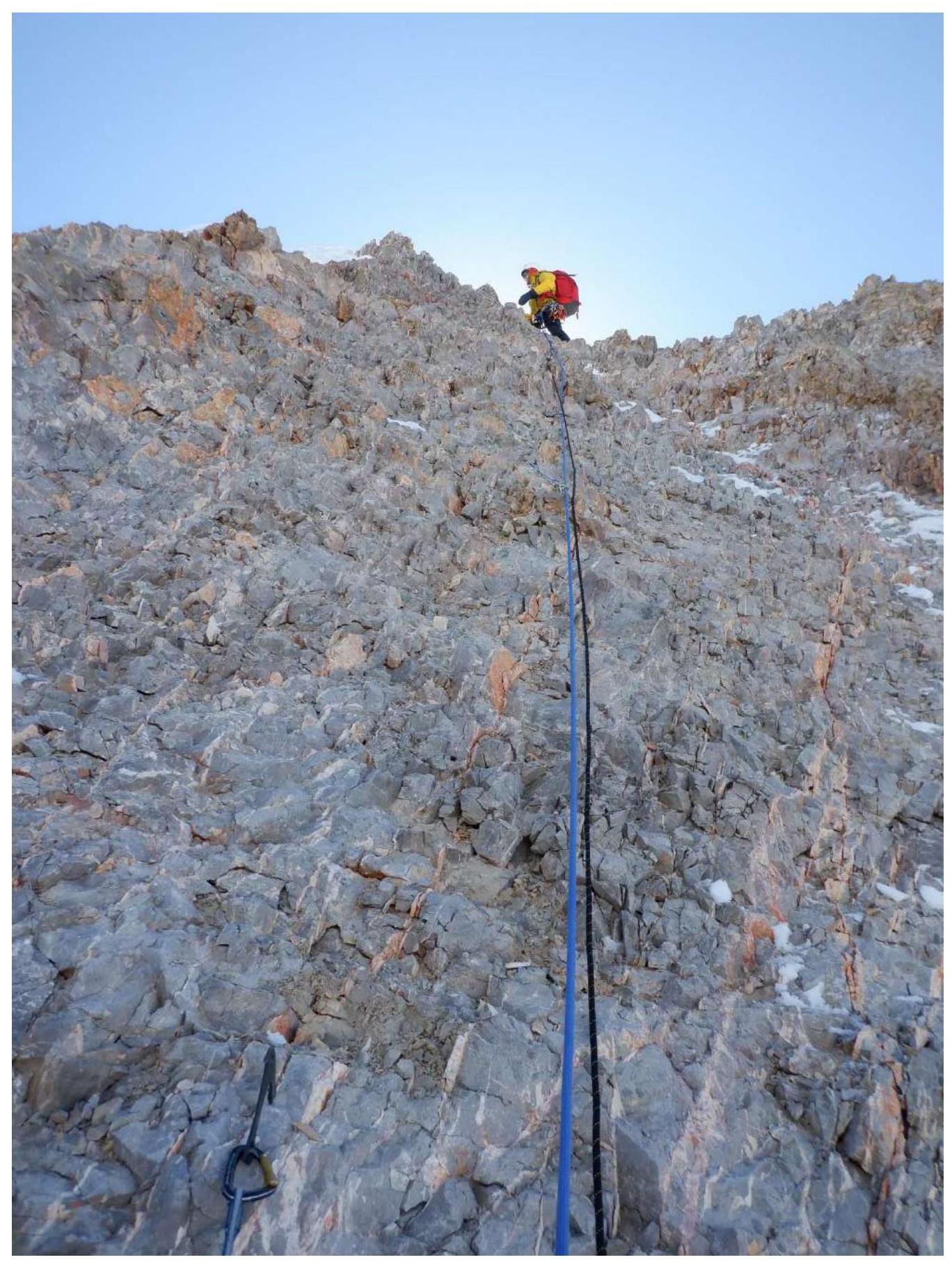
Photo 20. Section R16–R17
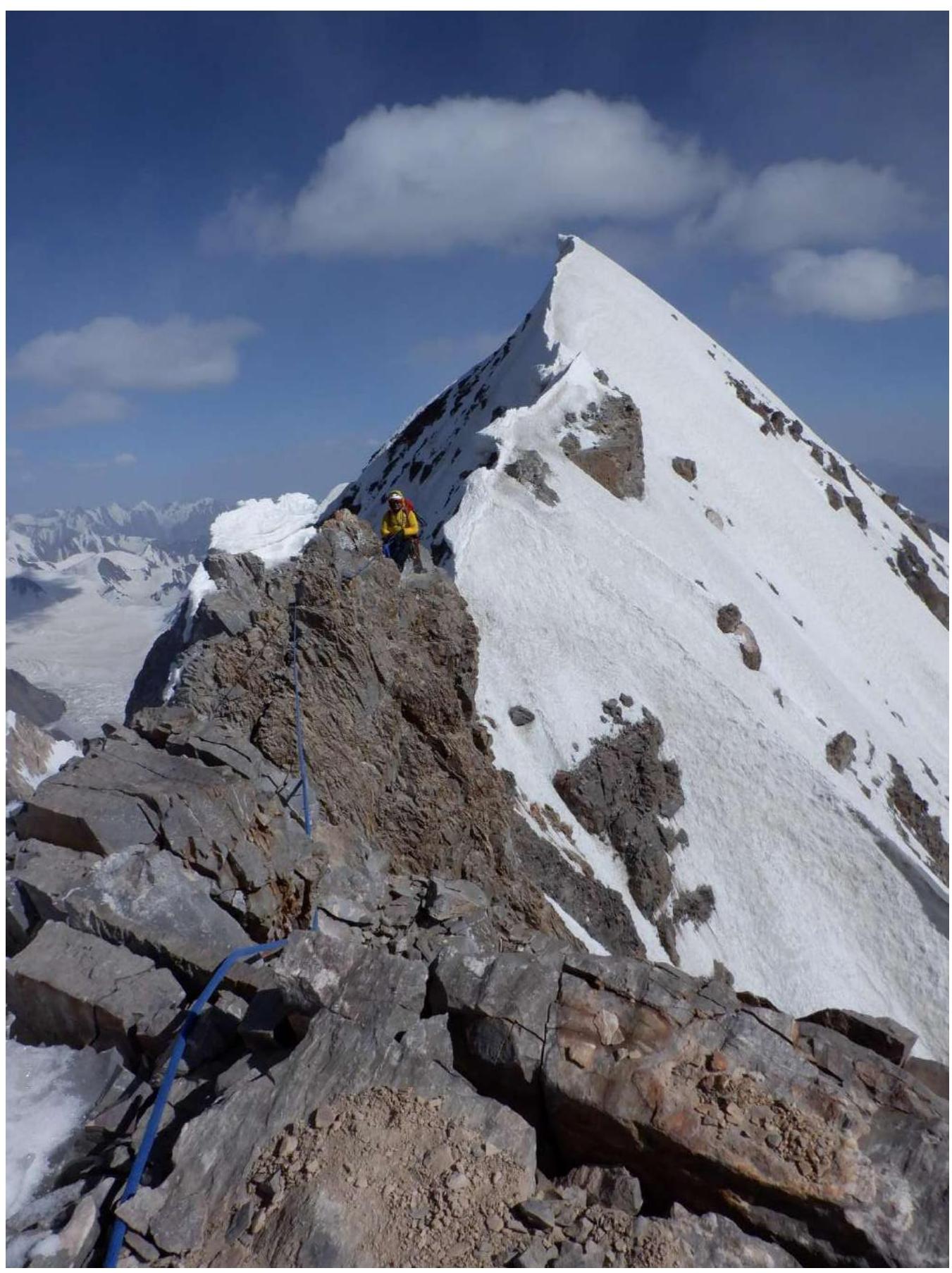
Photo 21. Section R17–R18. In the background — the summit of Kosmos Peak
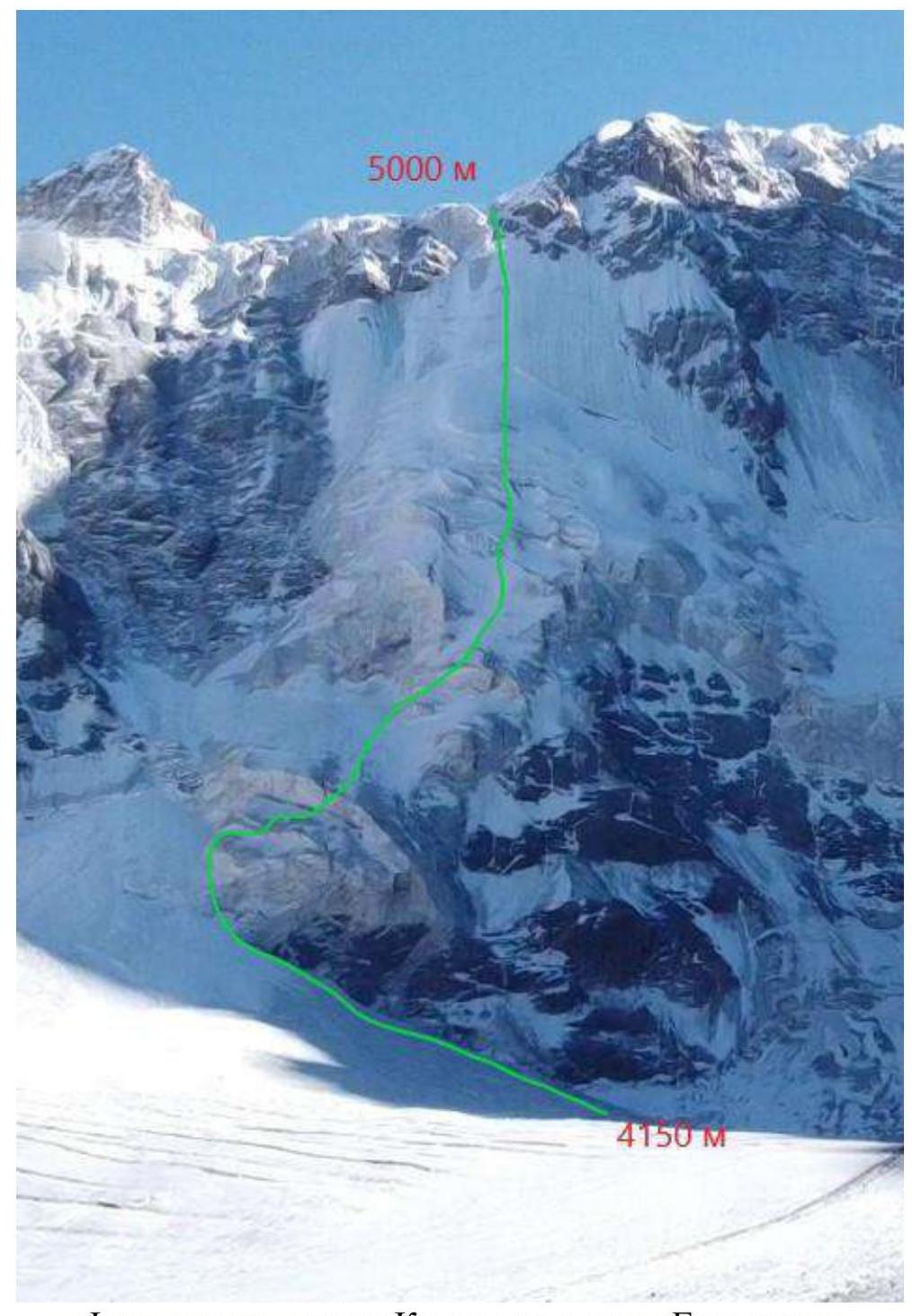
Photo of the descent from Kosmos Plateau to Grigoryev Glacier
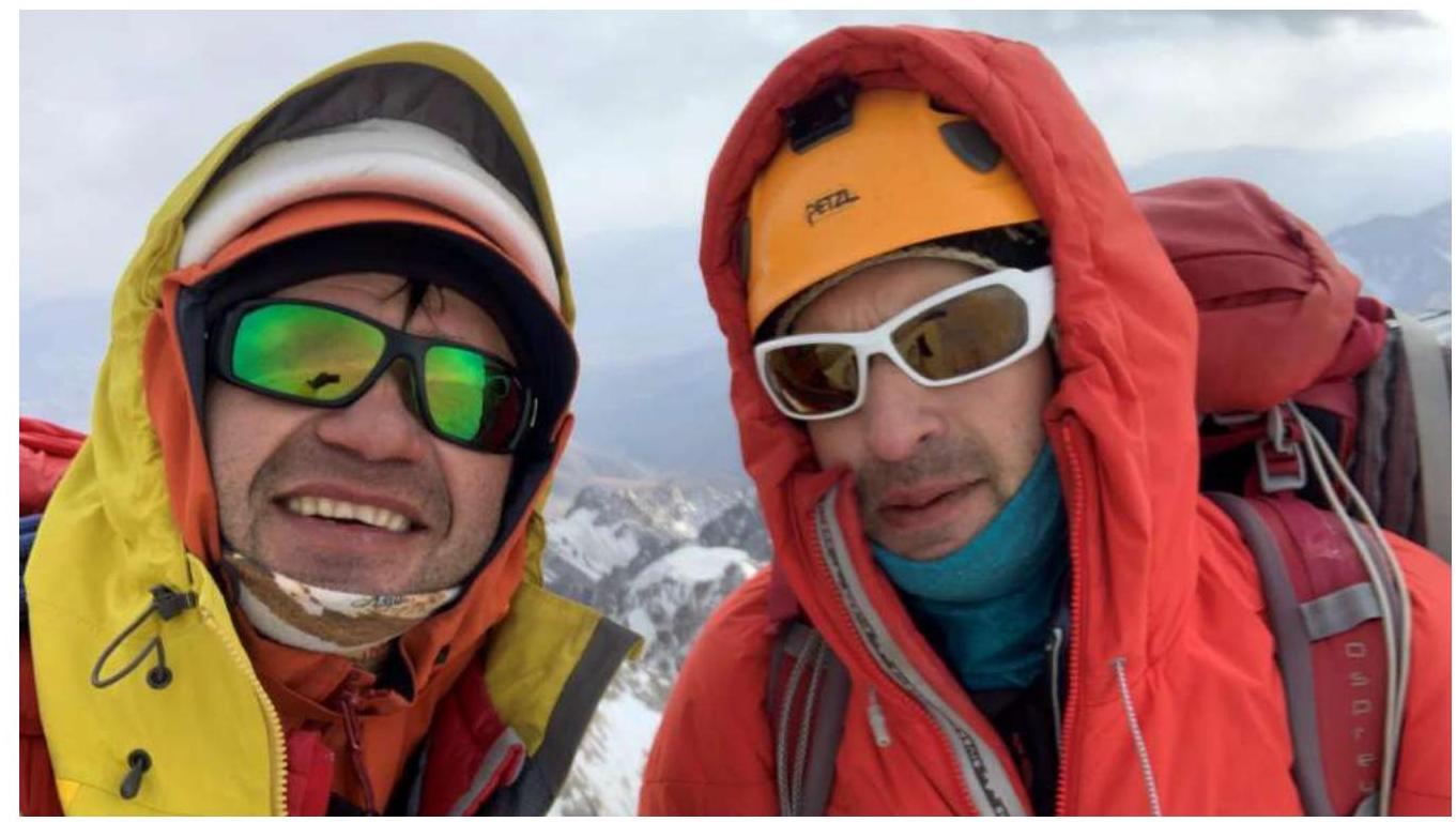
3.2 Photo of the Team on the Summit
3.3 Safety Assessment of the Route
The lower part of the wall is very hazardous due to frequent falls from ice barriers and hanging glaciers crossing the wall. Aleksandr Gukov was at the wall in winter 2020 and conducted reconnaissance, assessing bivouac sites and descent options. In winter, the wall is not as active as in September. After approaching the wall and observing, we found a virtually unique relatively safe passage through the center of the wall between the upper and lower ice barriers. However, all precautions were necessary — the route line was chosen to pass either under the protection of rocks or under the protection of a stable overhanging part of the ice barrier. Station locations were chosen under overhanging terrain features whenever possible. Both participants moved as quickly as possible through each section. The correctness of the chosen path was constantly emphasized by icefalls occurring to the right and left of the route. The first and part of the second day of the ascent were very emotionally tense. After passing the upper part of the second ice barrier, the route becomes relatively safe. However, it's essential to understand that a safe descent from this point is only possible via the summit ridge, as descending along the ascent line is extremely difficult and hazardous.
The route also has a very limited number of bivouac sites, and there are none in the upper part of the wall. All this must be planned when planning ascents and being prepared for sitting and very uncomfortable bivouacs.
For communication on the route, the team used a Garmin InReach Explorer+ satellite communicator. A helicopter evacuation possibility was agreed upon with the receiving party, and corresponding insurance was purchased with coverage of up to 40,000 euros.
The descent was greatly aided by recommendations from Ilya Mikhalyov, who attempted to ascend the peak from the east with a team in 2019. The descent from the summit was made along the southeast ridge, followed by a rappel down the eastern ice wall to Kosmos Plateau (10 ropes). The plateau is heavily crevassed in its middle and lower parts. It's better to traverse it: — along the right part to a small, isolated peak; — descend along its slope to the middle part of the plateau; — traverse to find a passage through the icefall to the ice tongue descending to Grigoryev Glacier.
Descent from the plateau is only possible in good visibility, with constant risk assessment of icefalls and adjustment of the route line.
3.4 Conclusion on the Preliminary Assessment of the Route Compared to Classified Routes of the Same Category
When assessing the complexity of ice sections, we considered ice sections from the Ruchkin and Semiletkin routes on Pik Svobodnaya Koreya
Comments
Sign in to leave a comment