
Passport
- Class of high-altitude technical ascents
- Inylchek Ridge
- Peak Shokal'skogo via the northeast wall
- Complexity category — 6
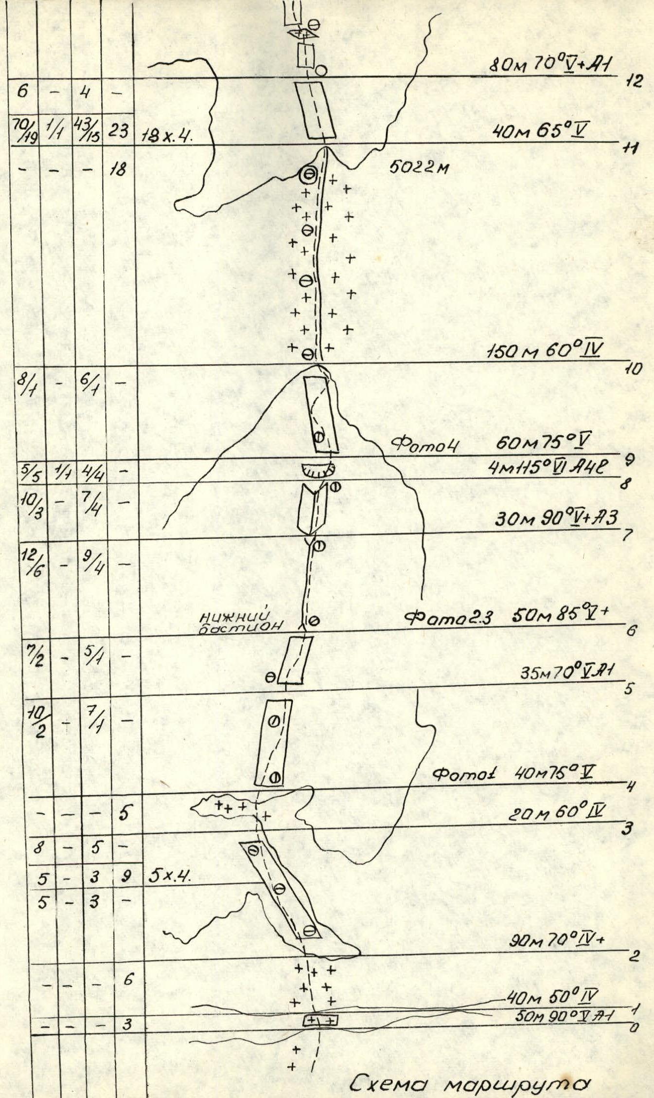
- Height difference — 1172 m. Total route length — 1362 m. Length of sections with 5–6 difficulty grade — 824 m. Average steepness of the main part of the route — 71°
- Pitons hammered:
| 135 | 4 | 109 | 53 |
|---|---|---|---|
| 46 | 4 | 41 | 0 |
- Team's travel hours: 56, days — 6.
- Overnights: — 1st — semi-reclining, on an ice ridge. — 2nd, 3rd — reclining, on a rocky-ice ledge. — 4th — sitting, on a rocky ridge.
- Team leader — Darmin E.N. — MS
- Participants Danichkin A.M. — MS, Vakurin V.V. — MS, Popov F.E. — MS, Komissarov V.A. — CMS, Guber G.D. — CMS
- Coach: Kuropatkin V.P. — CMS
- Entry to the route: July 30, 1985.
Return from the route: August 4, 1985.
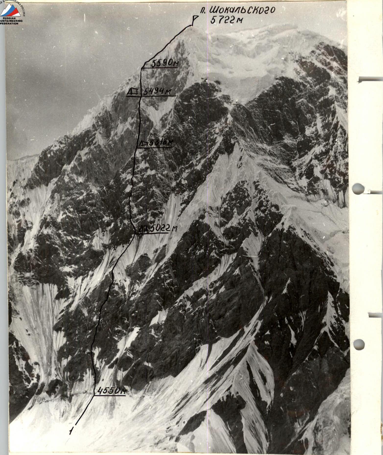 I — team's route. Taken — July 28, 1985, 11:00. T-22 lens, focal length — 75 mm. 2200 m to the object, point #1, height 4600 m.
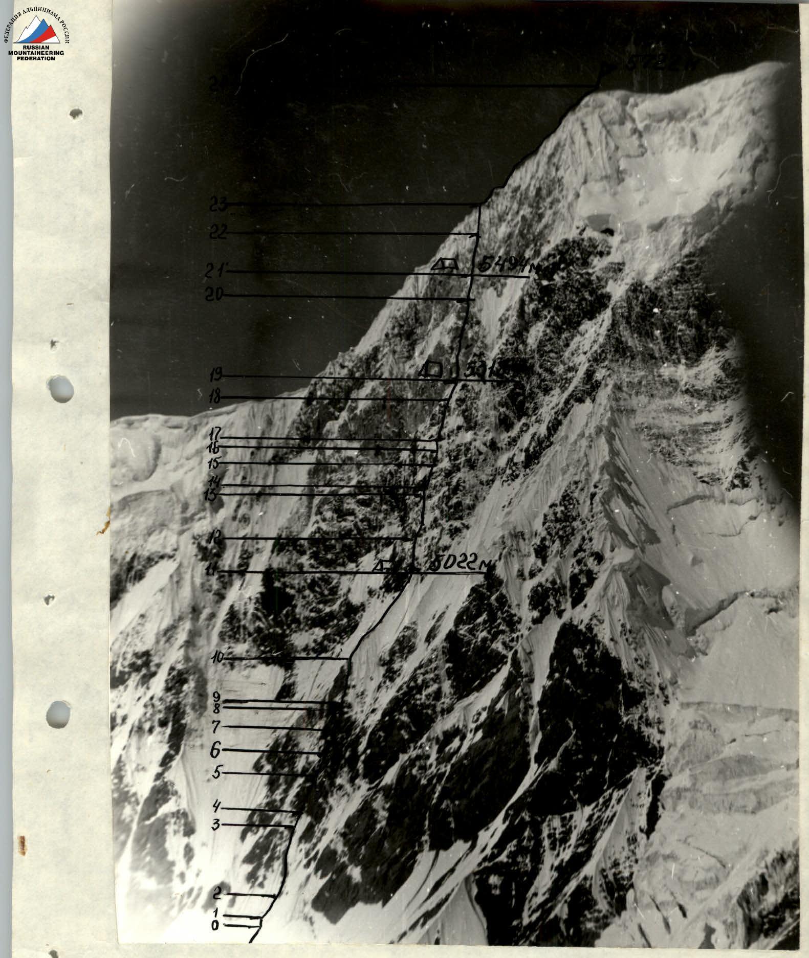
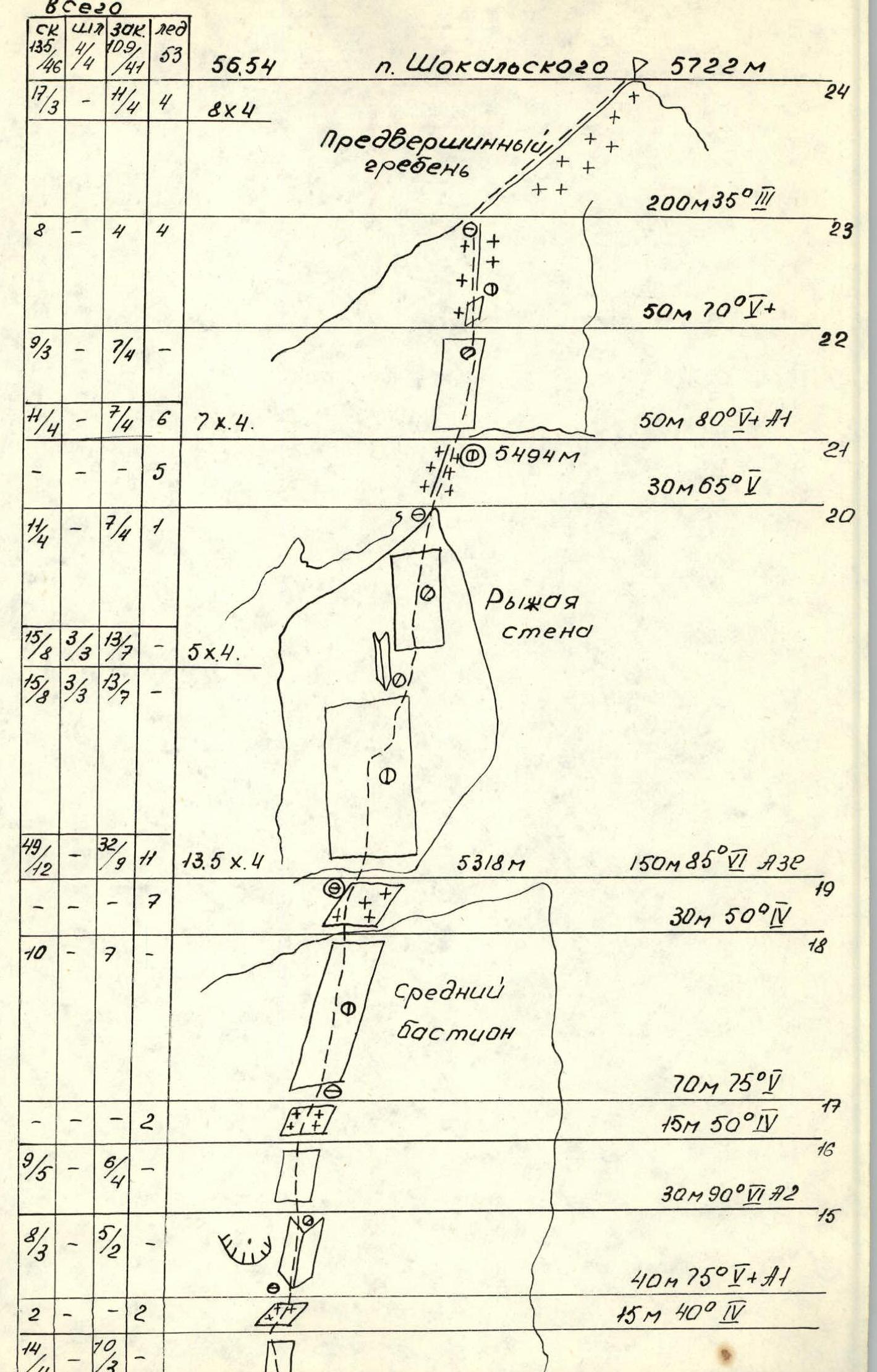
ROUTE PROFILE FROM THE RIGHT
Taken July 25, 1985, 11:00. T-22 lens, focal length — 75 mm. 1000 m to the object, from a helicopter, height 4900 m.
Team's Tactical Actions
During the ascent, the tactical plan developed by the team was fully followed. Except for the location of the third overnight stay (it was planned at the exit to the ridge). A sharp deterioration in weather conditions did not allow the team to reach the pre-summit ridge that day.
During the ascent, the team worked on a double rope. The lead climber used one foreign-made rope and one Soviet-made rope. The group had 6 ropes, so all participants moved along the fixed ropes with top-rope belay. The last climber on horizontal sections (traverses) organized fixed ropes for himself with subsequent rope-dragging, for which pitons with loops were left on the route. For more dynamic movement in the group, the entire load was divided into 5 backpacks: the lead climber had only equipment, and the last climber had a lightened backpack. Pulling backpacks on difficult sections was not used: the backpack was suspended on a belay rope, which allowed moving 2–3 meters along the fixed ropes, and then pulling it up, and so on.
On the route, each participant worked as the lead climber, except for Popov, which was generally planned in advance by the tactical plan. The lead climber was changed every 3–5 rope lengths, depending on the route's complexity. The lead climber worked with maximum effort, as the group's speed depends only on him. During the day, the group did not stop for lunch: each participant had their own individual ration with high-calorie products.
The lower bastion is quite steep, and therefore relatively safe, except for the lower part, which was climbed early in the morning. In case of deteriorating weather conditions, the group had a reserve of food and warm clothing, so the day spent waiting at the second overnight stay was not unexpected for the group.
At the overnight stay: — all participants were in helmets and on self-belay; — fixed ropes were organized from the main rope. Communication with observers was carried out from 8:00 to 20:00 every 4 hours using an RTP-70 radio station. If the group worked after 20:00, an additional radio session was scheduled.
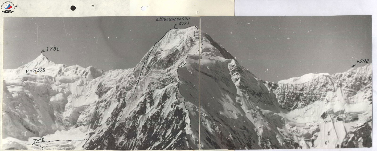
Photopanorama of the Area
— peaks; — shooting points. Taken July 25, 1985, 11:00. T-22 lens, focal length — 75 mm. Distance to the object — 3000 m, from a helicopter, height 5100 m.
Description of the Route by Sections
R0. Bergschrund 1.5 m wide. Passed with the help of an "ice axe anchor". R1–R2. Ice slope of moderate steepness, covered with a fragile crust of snow in the lower part. R2–R3. Steep rocks, but with a large number of holds. Climbed with free climbing. R3–R4. Ice of moderate steepness. R4–R5. Rock wall with a small number of cracks. Mainly climbed with free climbing. R5–R6. Rocks, most cracks are filled with ice. R6–R7. Crevice, movement is only possible through it, monolithic walls on the right and left. R7–R8. Steep inner corner, a lot of artificial climbing. R8–R9. Cornice at the top of the inner corner, passed on the right side (vertical crack). R9–R10. Steep rock wall with a small number of holds and cracks. R10–R11. Ice ridge covered with a thin layer of snow (10–15 cm). R11–R12. Rocks of moderate steepness. R12–R13. Rock wall, heavily filled with ice, some sections climbed with "ice axe anchors". R13–R14. Ice ledge with deep loose snow. R14–R15. Inner corner, heavily filled with ice. Constantly had to clean rocks from ice and snow to find cracks and holds. R15–R16. Sheer rock wall. R16–R17. Steep ice ledge. R17–R18. Steep rock wall with a vaguely defined ridge. R18–R19. Snow-ice ledge. The large thickness of snow allows organizing a comfortable platform, although it takes a lot of time, as the snow is dry and loose. R19–R20. Key section of the route — monolithic sheer wall, small number of holds. A lot of artificial climbing, use of pitons. The passage of this section was complicated by bad weather. R20–R22. Steep ice ridge. R21–R22. Steep rock wall, heavily filled with ice. R22–R23. Vaguely defined rocky-snow ridge. Dry loose snow, had to dig a trench to reach the rocks and ice for piton placement. R23–R24. Snow ridge of moderate steepness with a large number of cornices.
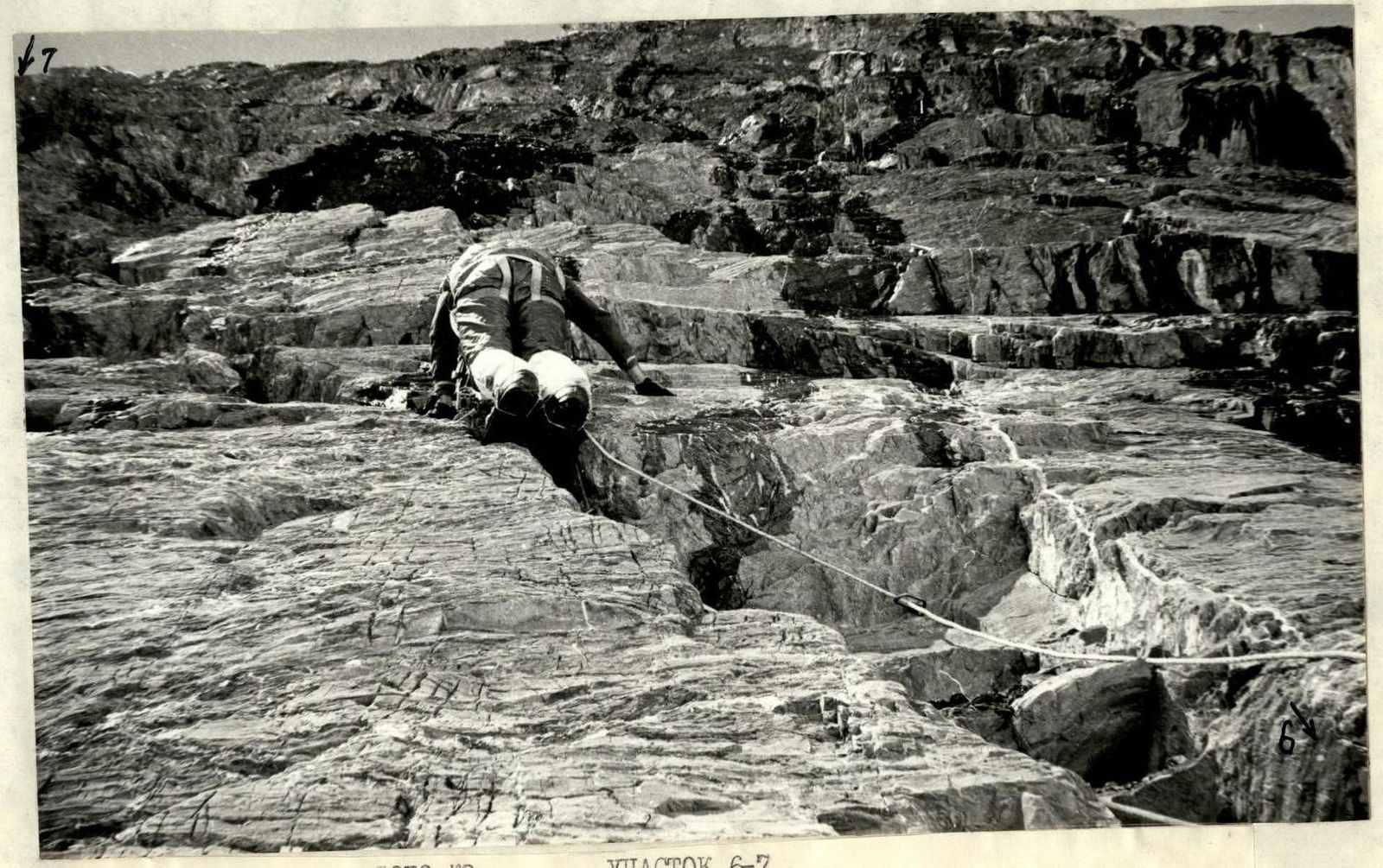 Passing the crevice. Taken July 31, 1985, 11:00. T-23 lens, focal length — 40 mm, point #4.
Comments
Sign in to leave a comment