MOSCOW ALPINISM AND ROCK CLIMBING FEDERATION
Report
On the ascent of the CSKA team named after Demchenko
To the summit Chudo (5100 m). Central Tien Shan, Western Kokshaal-Too
(41°2′41.03″ N. 77°29′33.94″ E)
via the Western ridge. First ascent, presumably 2B category of difficulty.
Zaryaev V.V. — Sharifullin R.F. 2015
Dedicated to Anastasia Shurtakova
Participants of the ascent
- Team leader — Zaryaev Vladimir Valerievich¹. 2nd sports category. Address: 117465, Moscow, Profsoyuznaya st., 156, bld. 1, apt. 384. VVZaryaev@yandex.ru, +7 903 105 8148
- Sharifullin Ruslan Folurovich. 1st sports category.
Coach: Kuznetsova E.V.
Route 2B to the summit Chudo via the Western ridge
Ascent passport
- Central Tien Shan, Western Kokshaal-Too range, Sarychat gorge, classifier section: 7.5.
- Chudo 5100 m (41°2′41.03″ N. lat. 77°29′33.94″ E. long.) via the Western ridge.
- Proposed category of difficulty — 2B, first ascent
- Route type: snow-ice
- Route elevation gain: 290 m (according to Google Earth image)
Route length: 2000 m (from Malitskiy glacier). Average slope:
- main part of the route — 20°;
- entire route — 10°.
- Number of pitons left on the route:
total — 0; including bolted pitons — 0.
- Team's total climbing hours: 4 hours (excluding descent, from the bivouac on the col between peaks Korsun and Chudo), 1 day
- Team leader: Zaryaev V.V., 2nd sports category
Participants: Sharifullin R.F., 1st sports category, instructor № 1379
-
Coach: Kuznetsova E.V.
-
Departure from the bivouac on the col between peaks Korsun and Chudo: 09:00, August 17, 2015. Route started: 09:00 August 17, 2015. Summit reached: 13:00 August 17, 2015. Return to base camp: 16:00 August 17, 2015. Descent from the summit: via the ascent route.
-
Organizations: Moscow Alpinism and Rock Climbing Federation, CSKA named after Demchenko, Zelenograd Alpinism and Rock Climbing Club
-
Person responsible for the report — Zaryaev Vladimir Valerievich.
VVZaryaev@yandex.ru, +7 903 105 8148
General photograph of the summit
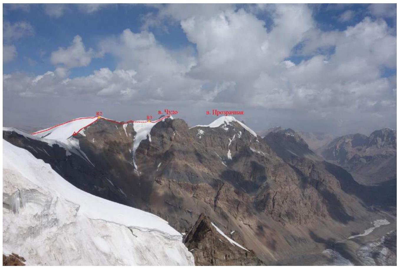
Fig. 1. View of peak Chudo from peak Sedoy Strazh.
Photographs of the route profile
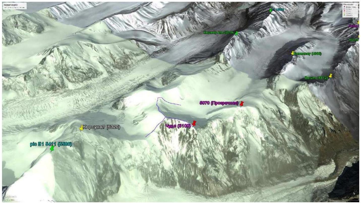
Fig. 2. Ascent route on a Google image (two options: from Korsun pass and from Malitskiy glacier)
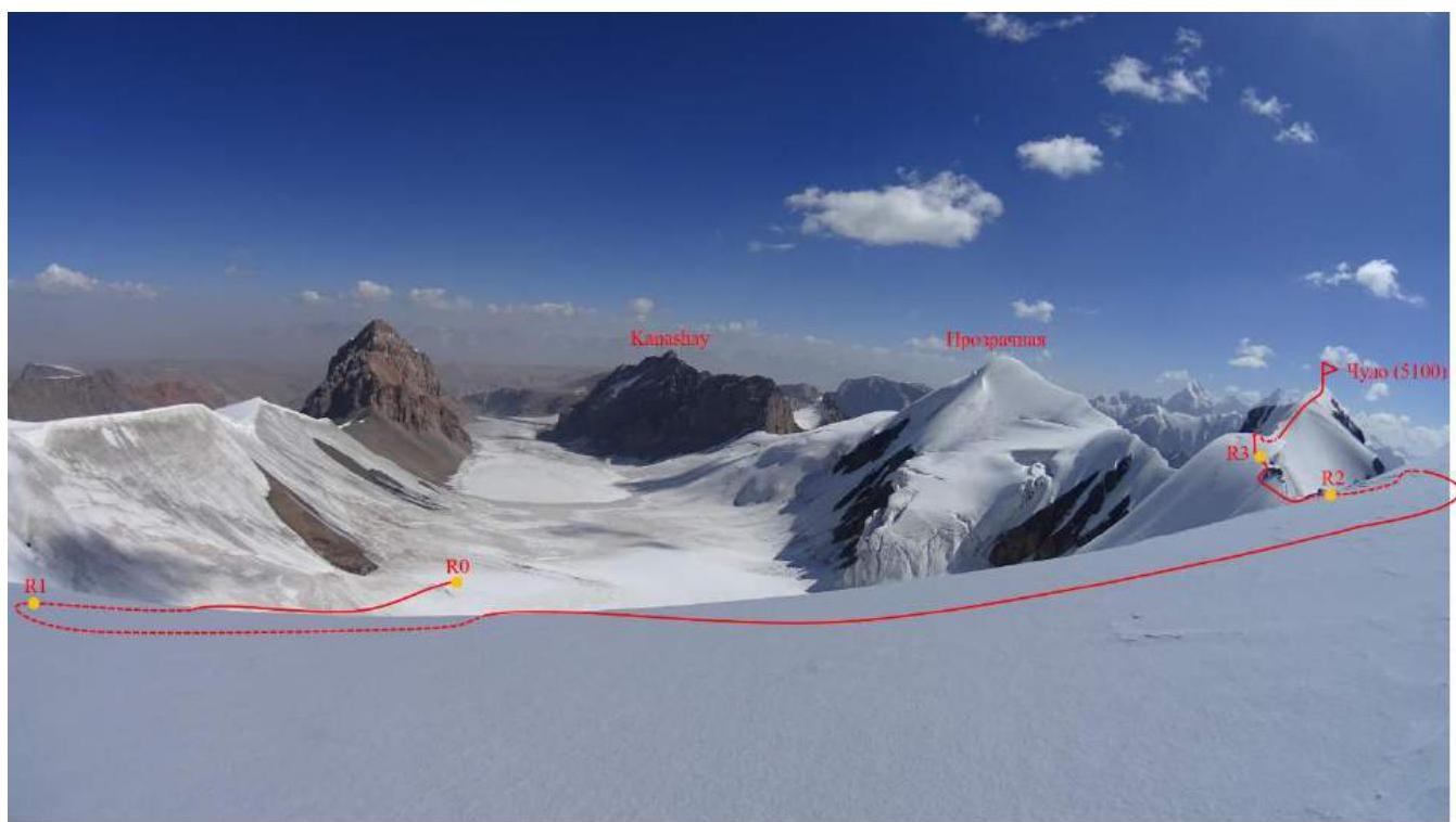
Fig. 3. Peak Chudo. Photo from the route along the 3rd ridge (Svetly put pass — see fig. 14 — to the left). View of Malitskiy glacier.

Fig. 4. Peak Chudo. Photo from Malitskiy glacier. Route along the 3rd ridge.
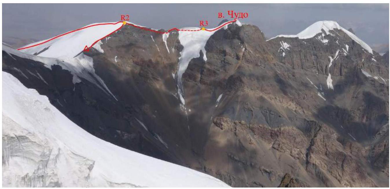
Fig. 5. Peak Chudo. Photo from peak Sedoy Strazh. Route along the 3rd ridge. Two route options are indicated:
- from Malitskiy glacier
- from the col between peaks Korsun and Chudo.
Photopanorama of the area
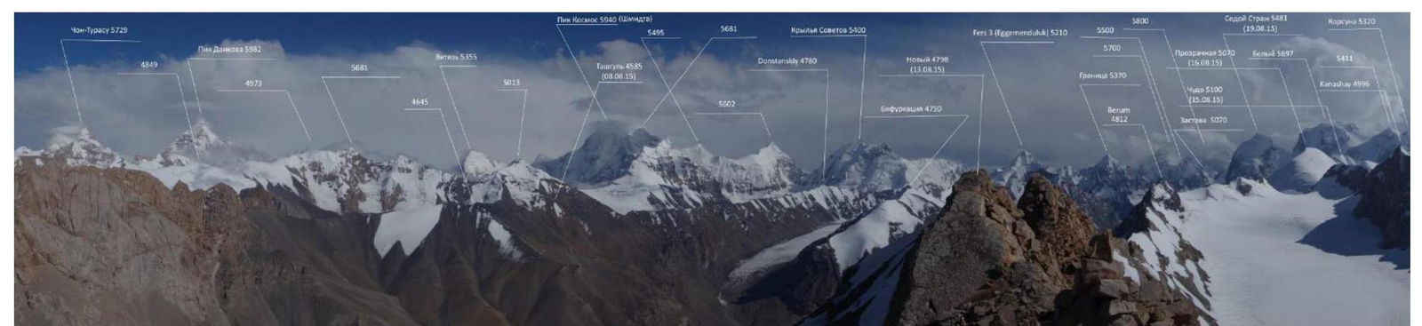
Fig. 6. Photopanorama taken from peak Novy to the south.

Fig. 7. Map of the area.
Central Tien Shan, Western Kokshaal-Too range, peak Beliy (5486 m) area
Brief description of the area
Western Kokshaal-Too is the southernmost range in Kyrgyzstan. This range is located in the Central Tien Shan between Lake Issyk-Kul and the Takla-Makan desert, on the border of Kyrgyzstan and China. To the north, the Kokshaal-Too range borders the Uzengy-Kuush and Mudyryum rivers, to the south — the Kokshaal River.
There are many peaks around 6000 m in this area. The most interesting among them are: peak Kyzyl-Asker (5842 m), peak Krylya Sovetov (5800 m), peak Shmidt (5954 m, not climbed), peak Dankova (5982 m), peak Chon-Turasu or Joldash (5729 m), peak Alpinist (5641 m), peak Sergey Korolev (5816 m). This area is characterized by a combination of typical Alpine forms (many vertical rock walls with a height difference of about 1.5–2 km) and extensive glaciation, second only to the Peak Pobeda area in Tien Shan. The entire area, including the lowlands, is permafrost. There are often marshy areas up to elevations of 4000 m.
The snow line is at an altitude of about 4000–4500 m above sea level. River valleys have a high absolute height of about 3000–3500 m above sea level. The climate in the valley is harsh. The average monthly temperature in summer is around 5–8 °C, and the weather is unstable.
Approach
 to the Autali River (fording in case of flooding or crossing on stones upstream or downstream depending on the weather). Then along the Sarychat River to the last grassy areas on the slope, about 1 hour before the melted tongue of the glacier. The base camp is set high above the river, in a flat depression protected from the wind.
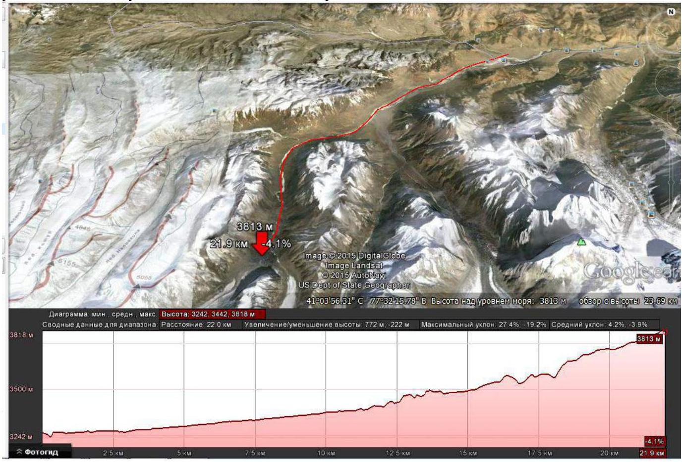
Fig. 9. Map of the path from the hunting lodge to the base camp in the Sarychat gorge.
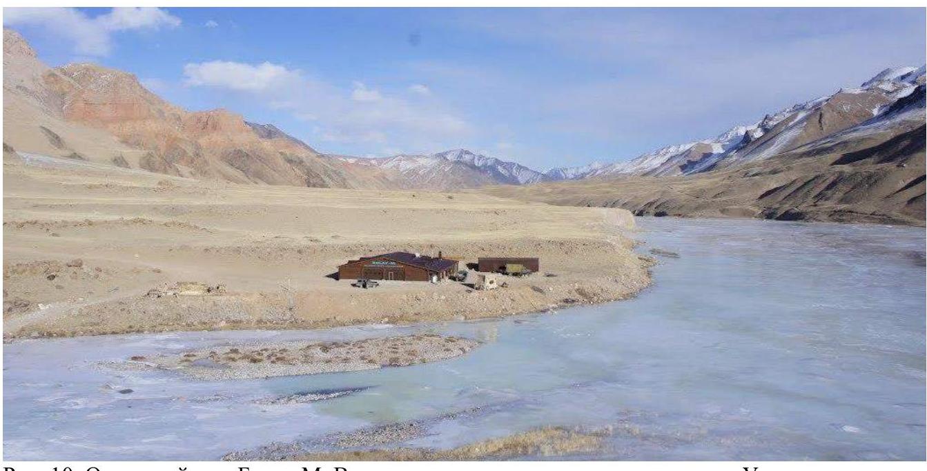
Fig. 10. Bulat-M hunting lodge. View from the southeast downstream along the Uzenigush River.
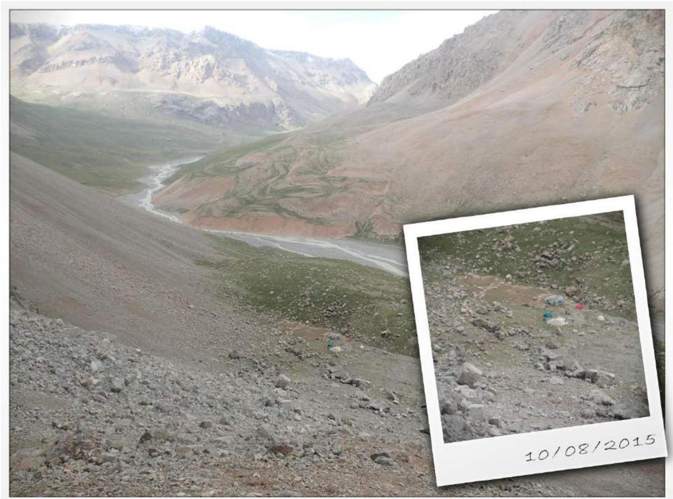
Fig. 11. Base camp in the Sarychat gorge.
Weather
The optimal time for expeditions here is considered to be the second half of July to the first half of September. The weather is unstable but with prolonged clear periods.
Bad weather is short-lived, almost always accompanied by strong stormy winds. Due to this, there are certain requirements for the base tent — it must be sufficiently wind-resistant.
In August, the weather cannot significantly affect the ascents, considering the nature of the routes. Even in good weather, it gets quite cold in the mountains. Taking all this into account, it is necessary to have:
- appropriate clothing
- the right mindset

Fig. 12. Map of the area indicating the location of the ascent.
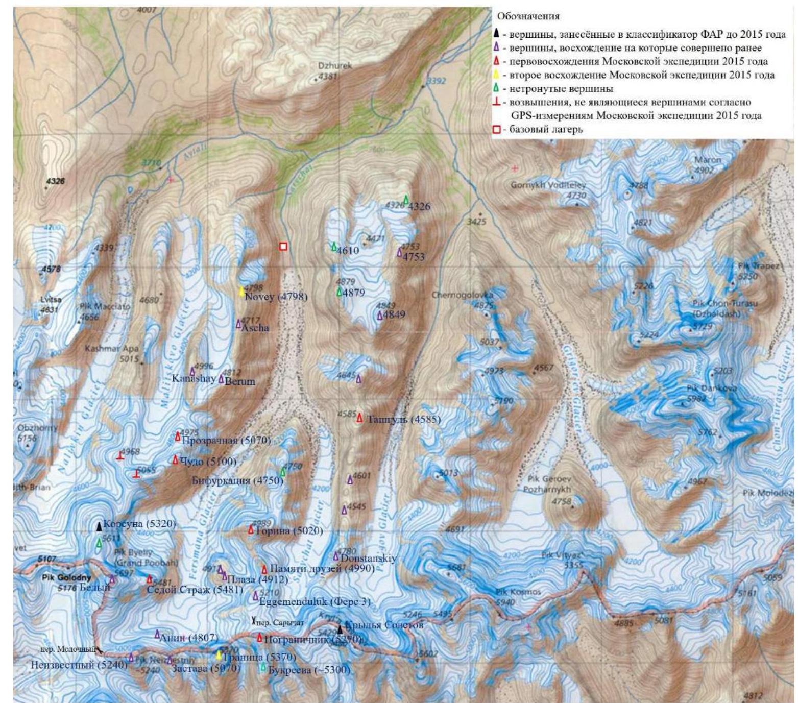
Fig. 13. Map indicating the peaks climbed during the 2015 Moscow team expedition.
Approach to the bivouac
There are several options for bivouacs and corresponding approaches from the base camp in the Fersman gorge.
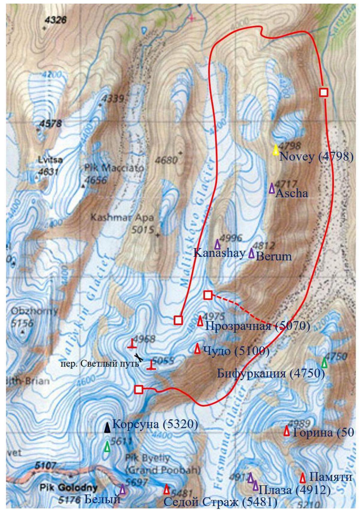
Fig. 14. Approach options (red lines) from the base camp (red square in the northeast corner) and bivouac options (red squares). 1st approach option — through Malitskiy glacier — is the most convenient. 2nd option — through Fersman glacier. The 3rd option, which was not explored, is indicated by a dotted line.
Bivouacs:
- Bivouac on Malitskiy glacier.
- On the col between peaks Prozrachnaya and Kanashay.
- On the col between peaks Chudo and Korsun («bivouac under peak Korsun», «Korsun pass»).
Approaches:
- Through Malitskiy glacier. This approach is the simplest. It was explored and used by us on the return journey to the base camp.
- Up the Fersman gorge, then from Fersman glacier to the col between peaks Korsun (5320 m) and Chudo (5100 m), connecting Fersman and Nalivkin glaciers. This option was used by us when approaching the summit, but it is quite labor-intensive as it involves climbing a steep scree slope (up to 20–30°).
- It can be assumed that an approach through the col between peaks Prozrachnaya (5070 m) and Kanashay (4996 m) is possible, but this path was not explored.
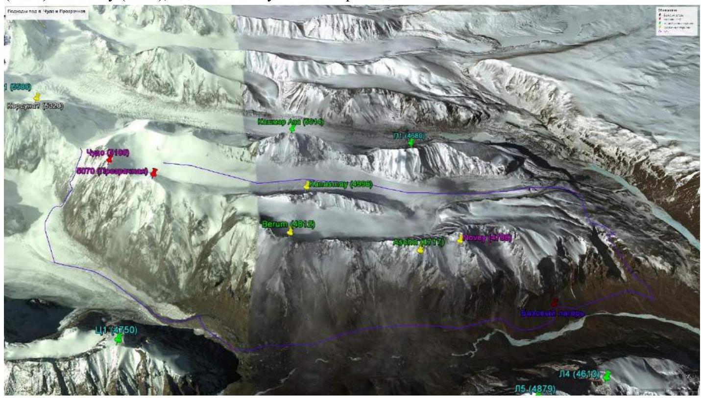
Fig. 15. 1st and 2nd approach options are indicated by blue lines. Below is a description of the three options.
1. Approach through Malitskiy glacier
Departure from the base camp. Descend to the entrance of the canyon along the grassy slopes. Cross the stream flowing from the canyon and climb up the steep grassy slope along a winding trail into the canyon. Walk along the bottom of the canyon (on the right — red rocks, on the left — a gentle scree slope with rock outcrops at the top). Continue to the end of the canyon (on the left, a waterfall over 50 m), turn right along the rocks, exit onto a stony slope, and climb up the scree slope to the southern edge of the canyon. Traverse around the canyon from the south to the north side along wide stony fields, similar to «Japanese rock gardens» (up to this point, the path coincides with the beginning of the route to peak Novy). Start traversing to the west. Walk 1.3 km, then, avoiding rock falls on the right, descend to the left down the scree onto Malitskiy glacier. Climb onto the moraine, walk along its ridge for about 100–200 m, and descend to the right onto the glacier. Then — upwards along Malitskiy glacier, to the right of peak Kanashay (4996 m), to the col between peaks Prozrachnaya (5070 m) and Kanashay (4996 m).
Bivouac options:
- On Malitskiy glacier. Water may be absent.
- Climb to the col between peaks Prozrachnaya (5070 m) and Kanashay (4996 m) (see the description of the route to peak Prozrachnaya), where there is a flat scree shelf and space for several tents. Water is absent (melt snow).
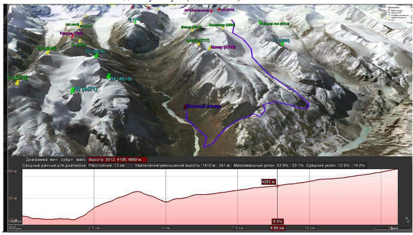
Fig. 16. Approach through Malitskiy glacier. The relief profile is shown below. Duration of the approach: 9 hours. Path length: 13 km. Elevation gain: 1400 m.
2. Approach through Fersman glacier and the col between peaks Korsun and Chudo
From the base camp, ascend along the orographic left bank of the river — first close to the river, and then between the moraines of the glacier (confluence of Fersman and Sarychat glaciers), «rock river» (accumulation of large boulders) leads to the right edge of the glacier. Navigate through the complex relief of the glacier, descend into the depression of Fersman glacier. Moving diagonally to the right among the boulder fields, climb onto the moraine. Follow the moraine approximately to the foot of peaks Chudo and Goriin. Here are convenient bivouac sites.
Then:
- Turn right
- Climb up the icefall into the cirque of peaks Sedoy Strazh, Beliy, Korsun, and Chudo
The ascent up the icefall is mainly along the right side and is not difficult. Along the glacier, approach the foot of the scree slope to the right of the col. The landmark is the stream bed under the rocks of peak Chudo.
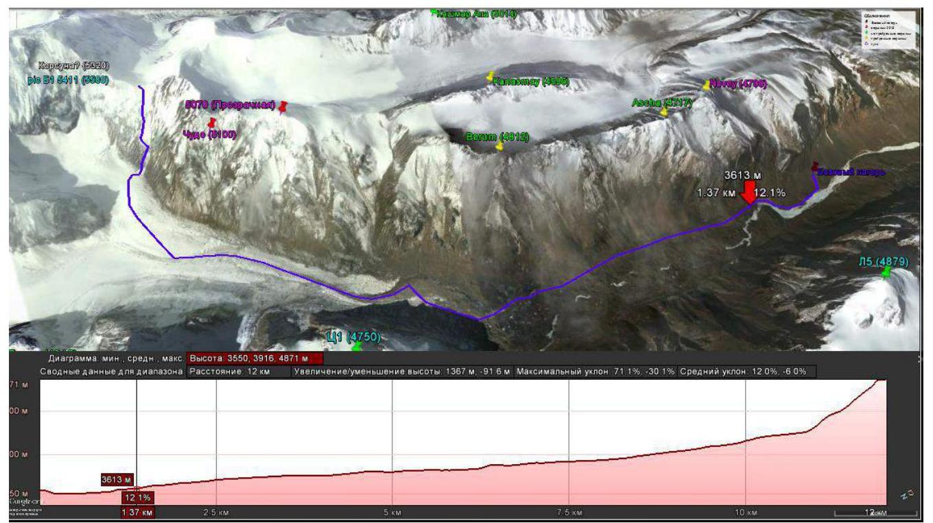
Fig. 17. Approach through Fersman glacier. The relief profile is shown below.
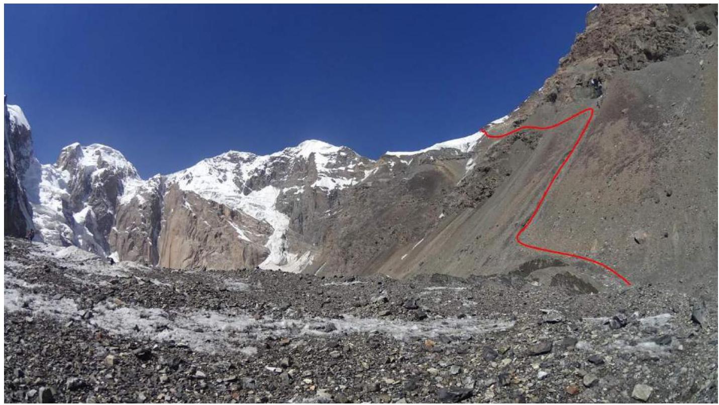
Fig. 18. Ascent to the col between peaks Korsun and Chudo.
Climb up the scree along the stream (may be dry) to the waterfall (movement along the gully is more convenient).
From the waterfall:
- Traverse to the left, avoiding rock falls from above;
- After passing the rock falls, move diagonally to the left and upwards (most labor-intensive section);
- Avoiding the snow-ice slope, climb to the col.
At the end, when transitioning to the col, crampons may be necessary.
On the col, there are scree shelves allowing for tent setup.
Duration of the approach: 12 hours. Path length: 12 km, elevation gain — 1400 m.
3. Approach through Fersman glacier and the col between peaks Prozrachnaya and Kanashay
It is presumably possible to safely ascend from Fersman glacier to the col between peaks Prozrachnaya (5070 m) and Kanashay (4996 m). To do this, as in the previous option, exit onto the moraine but travel significantly less along it. To the right, a gully will be visible, ending in an ice section — this is the path to the col.
As already mentioned, this path was not explored by us. Difficulties can be expected when passing the ice section, including rockfall hazards. Rocks are present in large numbers on the ice slope. However, when observing the ice section from the col, we did not see any falling rocks.
Technical photograph of the summit
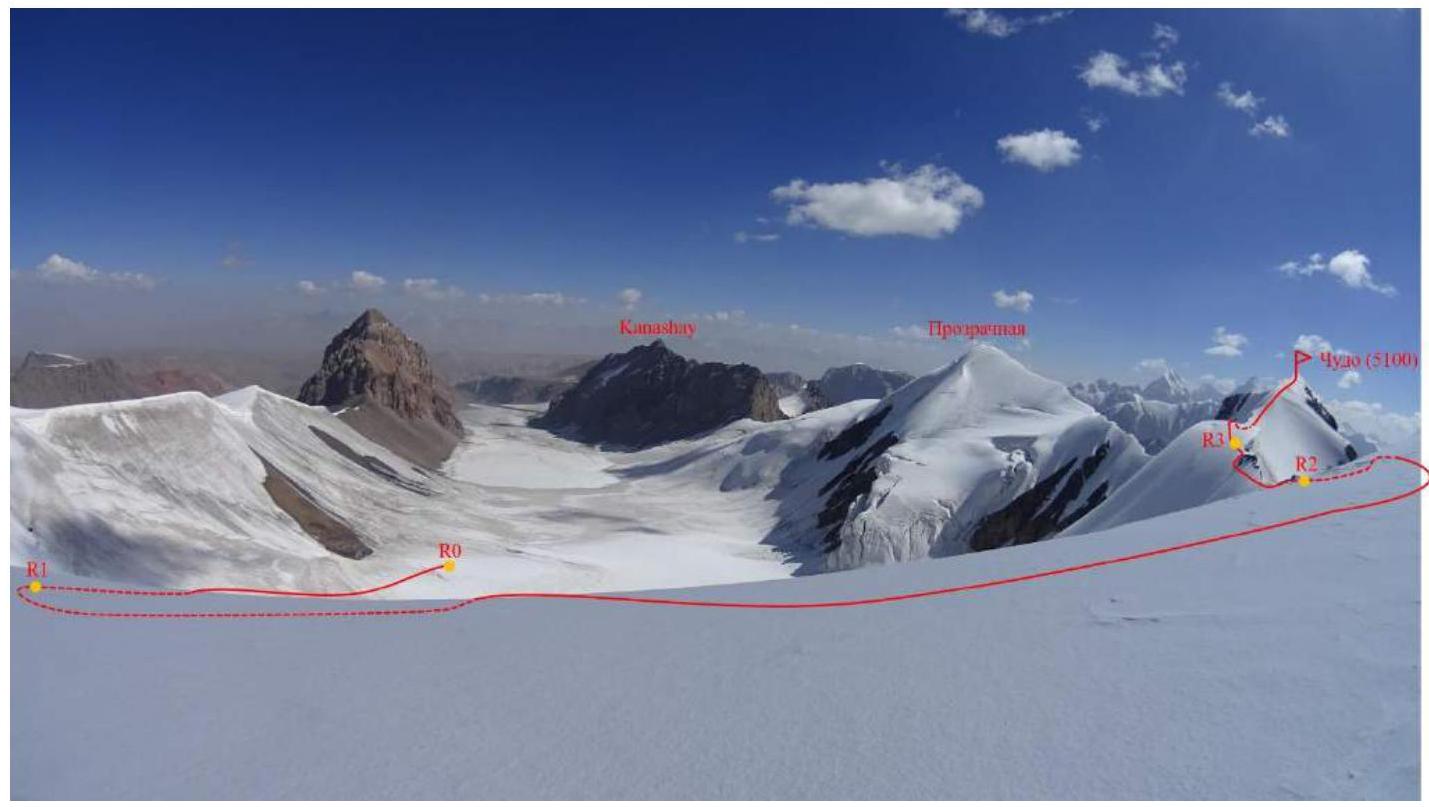
Fig. 19. Peak Chudo. Photo from the route (view of Malitskiy glacier from the ridge).
Description of the route's difficulty sections
| Section № | Length | Slope | Relief characteristics | Category of difficulty |
|---|---|---|---|---|
| R0–R1 | 600 m | 20–30° | Snow-ice slope, bergschrund | 3 |
| R1–R2 | 700 m | 0° | Snow ridge | 1 |
| R2–R3 | 300 m | 0–40° | Snow-ice ridge | 3+ |
| R3–Summit | 350 m | 0–30° | Snow-ice slope | 3 |
Brief description of the route passage by sections
The description is given from Malitskiy glacier (bivouacs 1 and 2). Along Malitskiy glacier, approach the snow-ice col in the southwest corner of the glacier — we will call this col «Svetly put» (see fig. 14). R0–R1. Snow-ice slope leading to the col. Movement in rope teams with simultaneous belay. In the middle of the slope — a bergschrund, which can be easily passed. 3, 20–30°, 600 m. R1–R2. Traverse along a gentle snow ridge to the west to peak 5055 (a cairn is built). 1, 0°, 700 m. From here, you can reach the bivouac under peak Korsun. R2–R3. Key section of the route. From peak 5055, move west along the ridge to the left, avoiding snow cornices and rocks. Movement in rope teams with simultaneous belay using ice axes. 3+, 0–40°, 300 m. Pass under the rocks and exit onto the ridge, onto a rocky-scree shelf at the end of the second pillar. R3–Summit. Traverse a few meters along the rocky-scree shelf and descend onto snow. Along the base of a large snow cornice, traverse the ridge from left to right, move to its right side. Then ascend along the right side of the snow-ice ridge to the summit. 3, 0–30°, 350 m. The summit is a snow cornice. A cairn is built on the rocky-scree shelf to the right, slightly below.
When ascending from the col between peaks Chudo and Korsun (bivouac 3), approach along the gentle ridge to the north to R2, then follow the description.
Descent
The descent from the route is made via the ascent route.
Recommendations for the route
In good weather, the route is short and safe. With abundant snowfall, it can be avalanche-prone — as evidenced by the report of the Anglo-Russian expedition in 2006 [http://publications.americanalpineclub.org/articles/12200730100/Asia-Kyrgyzstan-Western-Kokshaal-Too-Navlikin-and-Malitskovo-Glaciers-First-Ascents↗]. However, it seems that such a situation is rare. Belay is organized simply. Sometimes it is necessary to dig out the ice under a layer of firn.
Route length 2000 m, elevation gain 350 m.
In conclusion, we note that the traverse of peaks Chudo-Prozrachnaya is interesting. It appears to be significantly more difficult due to the presence of a strong depression in the ridge between them (see fig. 23) — rock protection is required.
Photo illustration of the report
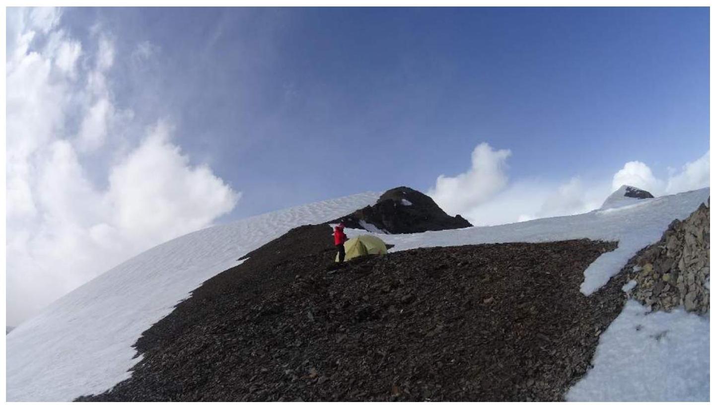
Fig. 20. Bivouac on the col between peaks Korsun and Chudo. Peak Chudo is visible in the upper right. The middle — peak 5055.
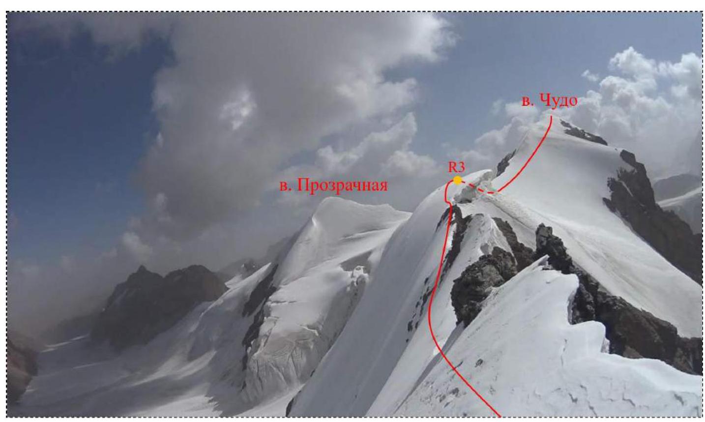
Fig. 21. Key section of the route (R2–R3).
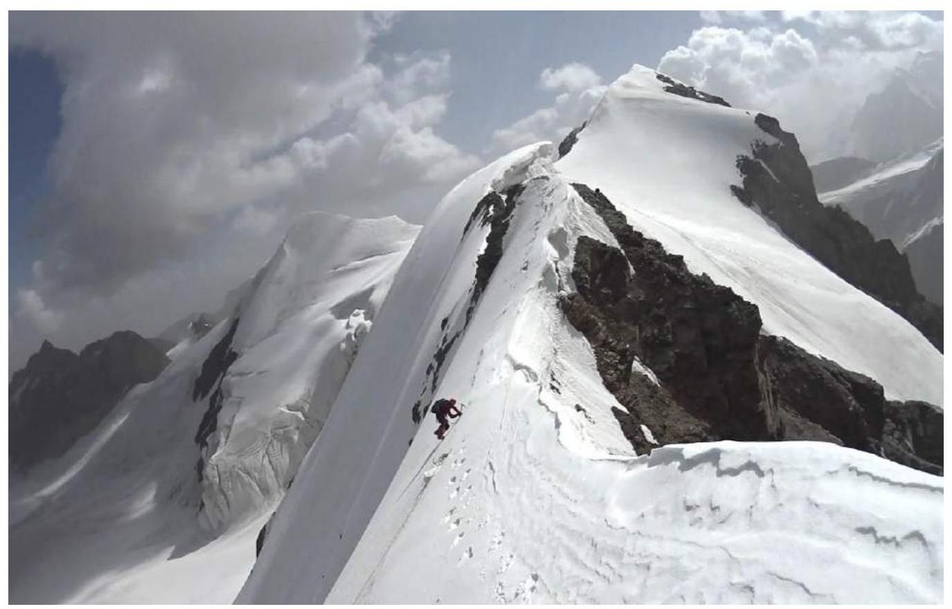
Fig. 22. Passage of the key section of the route (R2–R3).
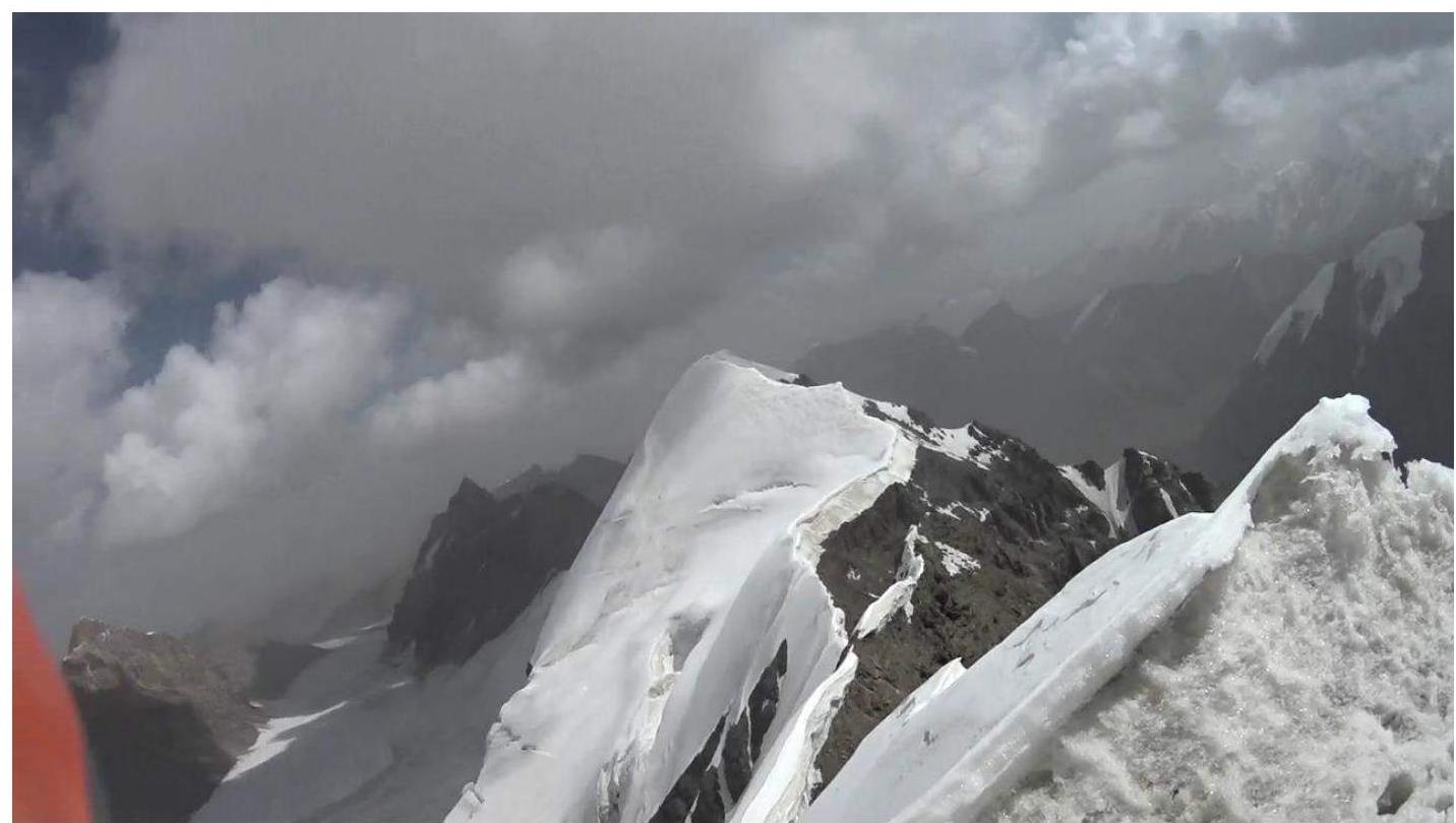
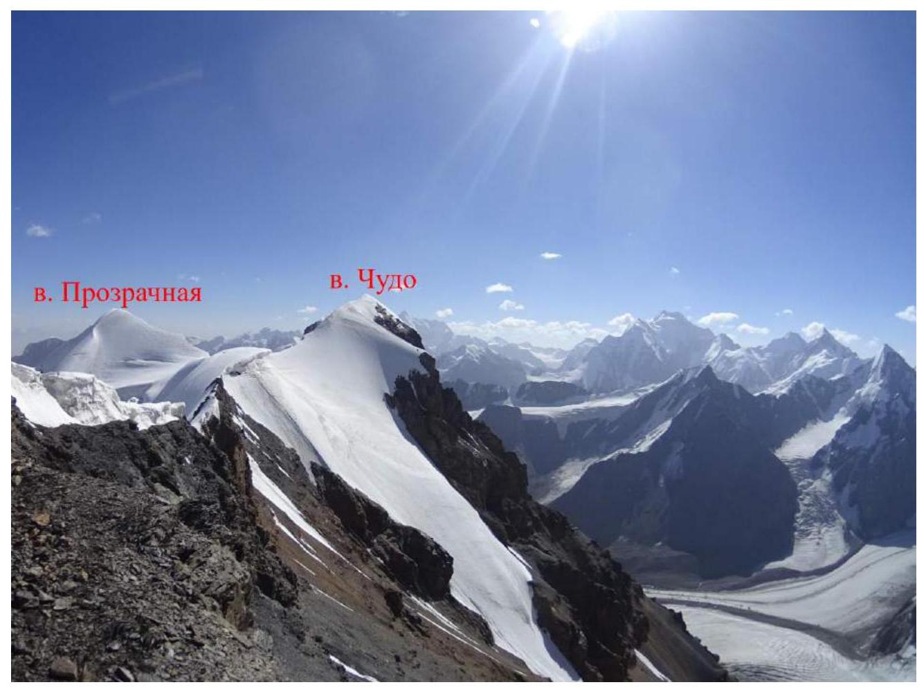
Fig. 23. View of peak Prozrachnaya from peak Chudo (visible in the lower right corner).
Dedicated to Anastasia Shurtakova
Footnotes
-
¹ Actual full name: Nikitin Vladimir Valerievich (Zaryaev — pen name) ↩