
Passport
-
Technical category
-
Tian-Shan, western Kokshaal-Tau, Chon-Turasu valley
-
Peak Trapeziya (5240 m) via the SE wall and East ridge
-
Proposed 5B category, first ascent
-
Height difference 1140 m.
Length 1970 m. Length of sections with 5th category difficulty — 460 m. 6th category difficulty — 92 m. Average steepness: main part of the route — 62°, entire route — 41°
-
Pitons hammered in:
rock 37/2, chocks 66/5, ice screws 22/0
-
Team's moving hours 26 and days 4
-
Overnight stops:
1st on a shoulder 2nd, 3rd — carved into a snow-ice slope
-
Captain: Starostin B.N., 1st sports category
Participants: Romanov V.A., CMS, Smirnov A.V., 1st sports category, Shmokhin I.A., 1st sports category
-
Coach: Akhmatov F.A., MS
-
Approach to the route — August 24, 1996.
Summit — August 26, 1996. Return — August 27, 1996.
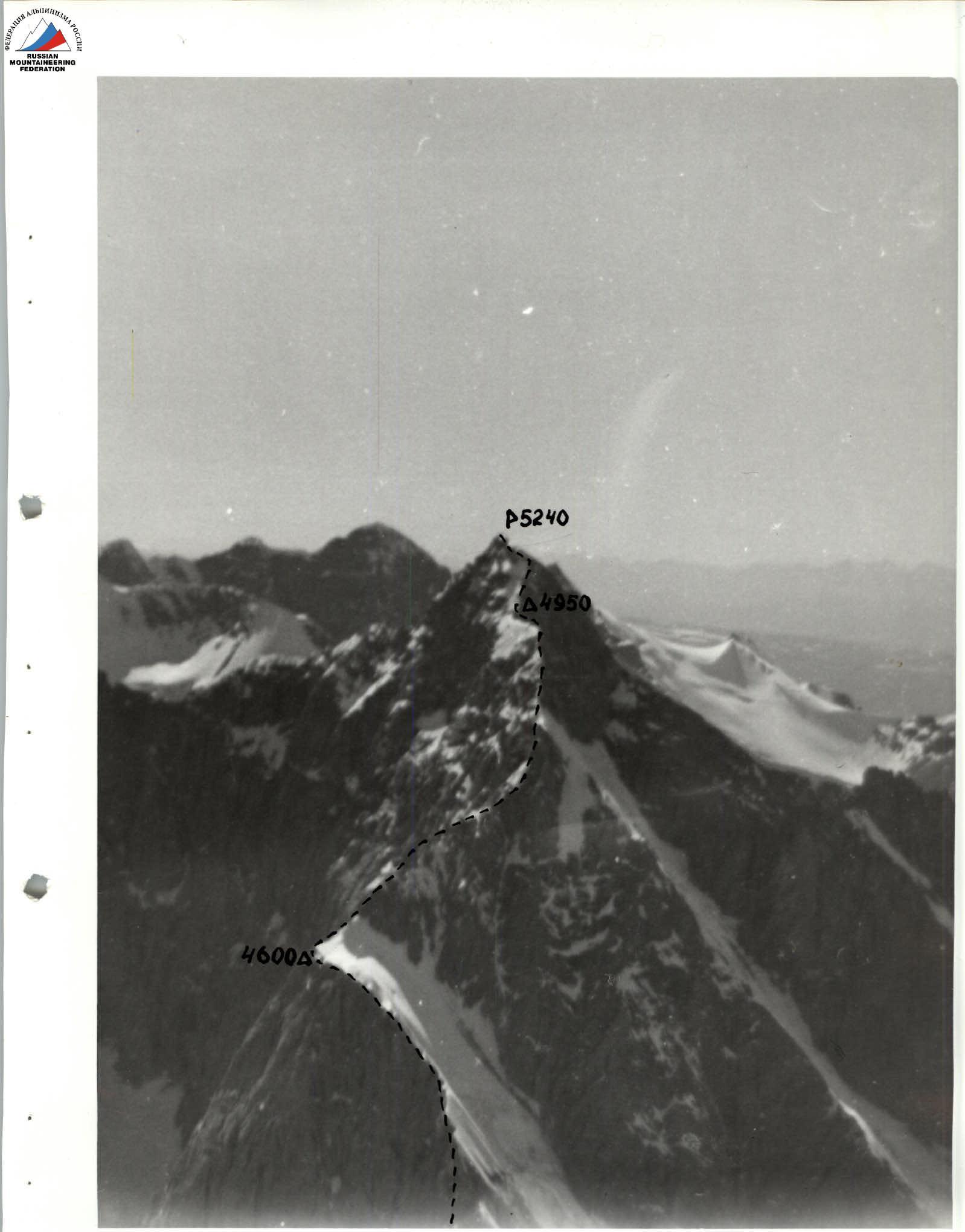
Photo 1. Peak Trapeziya. View from p. Kibal'chicha. September 10, 1996. H = 5000 m, L = 4000 m.
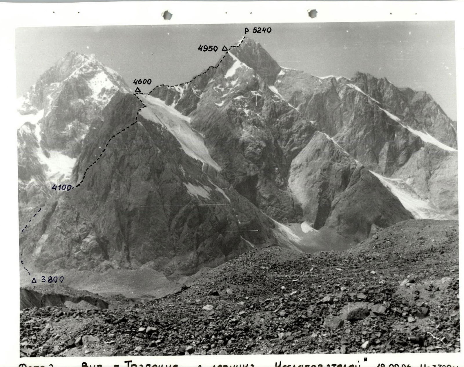
Photo 2. View of p. Trapeziya from the "Issledovateley" glacier. September 18, 1996. H = 3700 m, L = 2500 m. View from the right.
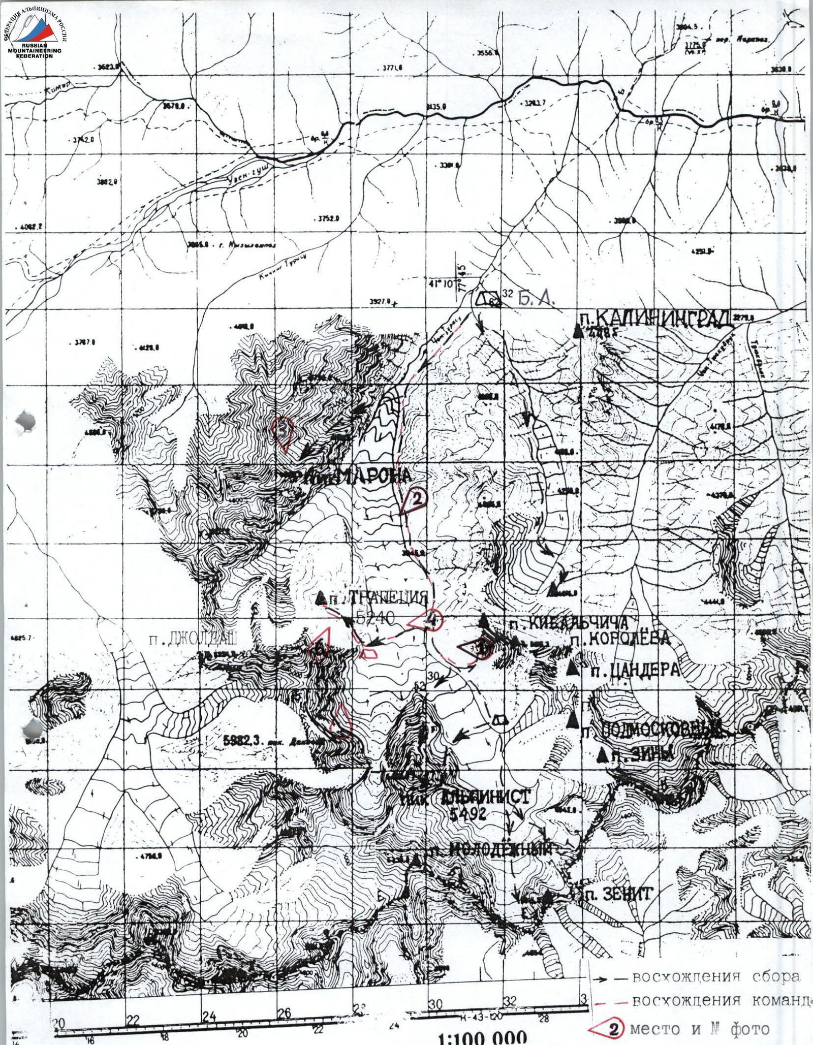

Photo 3. Panorama of the upper reaches of the Chon-Turasu valley. View from the N. ridge of peak Maron. July 25, 1993. H = 4800 m, L = 4000 m.
- 5B A. Korsun 69. 2. 5B A. Korsun 69. 3. P. V. Franco-German group 96. 4. E. Korenev 3B 69. 5. 6A M. Lebedev 93.
- P. P. V. Boyko 96. 7. P. P. Franco-German group 96. 8. 3A A. Berlyand 60. 9. P. V. 5B B. Starostin 96. 10. 1B A. Letavet 32.
Tactical actions of the team
August 24
The team left the overnight stop on the moraine of the glacier under the route at 7:15. The ascent via the scree to the center of the Eastern wall took 1 hour 30 minutes. The pre-planned route went diagonally from the center of the wall to the upper third of the right edge. At 9:00 they started working on the route. Starostin worked first on the entire route. The structure of the rocks (monolith without small cracks) did not allow the use of pitons. Intermediate belay points were organized using large chocks and friends. Steep rock sections on the wall alternated with inclined scree ledges. When reaching the ledges, attention and caution were necessary to avoid dislodging "live" stones.
When organizing belay stations, the leader constantly encountered difficulties. The available small cracks were usually blind and not suitable even for leaf-shaped pitons.
Stations were organized on tied chocks, for which there was not always a possibility. In two cases, to organize a reliable station, it was necessary to extend the rope.
At 15:20 they reached the edge of the wall. Further movement took place in crampons. Gentle sections of the ridge with snow cornices were traversed simultaneously below the line of detachment. On steep sections, under a thin layer of snow or firn, ice was found. Movement proceeded using ice screws. In the upper part of the steep ice slope, before reaching the lower shoulder (section), there were rock outcrops. When approaching them, the layer of ice became thin and the ice screw did not bite even to the length of the thread. To ensure reliable belay, they moved from the ice to the rocky ridge and along it reached the wide lower shoulder at 18:15. On the shoulder, there was an excellent place for an overnight stop in a wide snow hollow.
August 25
At 9:00 the team began moving along the route. The further route went along the ridge. The ridge was very narrow; rock pitches were climbed only head-on. The rocks of the ridge were heavily destroyed; maximum caution was necessary during movement. On gentle sections, movement proceeded as independent pairs. Belay was carried out through ledges. The ridge had three rock pitches:
- First pitch: rocks of medium difficulty, heavily destroyed, great difficulties with organizing belay.
- Second pitch: narrow chimney with a plug at the top, flowstone, then a vertical rock wall, holds clogged with snow, partially flowstone. During the passage of the wall, the leader experienced a "working" fall to a small depth (0.5 m): a hold came out under the right hand.
- Third pitch: snow-covered rocks, flowstone. An overhanging cornice at the exit is bypassed on the left.
The next rope length passes along a very sharp ridge, which abuts against a rock wall (120 m). The structure of the rocks is represented by "sheep's foreheads" (in the lower part) and monolithic blocks with wide cracks (in the upper part). From the ridge, a variant of bypassing the lower part of the wall on the right along a wide internal angle was visible, which led to the middle part of the wall; however, when approaching the wall, a large stonefall was observed exactly along the internal angle. As a result, it was decided to move directly along the wall to the left part of the internal angle and further along the rock blocks to the exit to the upper shoulder. The structure of the rocks ("sheep's foreheads") determined the complexity of passing the wall. A small number of holds with inconvenient orientation (directed downwards) added to the previous difficulties with organizing belay. The use of artificial aids (AIDs) was required. The wall was passed at 18:30. A site for an overnight stop was leveled in the snow ridge of the upper shoulder.
August 26
Movement began at 9:00. The first rope lengths went along a simple snow ridge, then — simple, heavily destroyed rocks with a small rock wall (6 m), gentle but without holds (passed on friction). Behind a small depression of the ridge followed a rock pitch (40 m):
- In the lower part — rocks of medium difficulty with flowstone;
- In the upper part — steep rocks (85°) with inconvenient holds, required maximum tension when passing.
The further path went along a simple ridge, partially rocky, partially snowy with large cornices (bypassed on the left). At 11:30 they approached the summit tower. The first 20 m — snow-covered rocks, then a steep ice slope under a thin layer of snow, with rock outcrops. Belay through ice screws, exit to the summit ridge through a 3-meter snow cornice. At 13:50 they were on the summit, built a cairn, left a note, at 14:10 they began descent. The weather was clear, visibility good. They descended to the upper shoulder to the site of the second overnight stop by 18:00.
August 27
At 10:00 they began descent from the upper shoulder along the ascent route, at 16:00 they were on the glacier. Throughout the route, the team maintained contact with the base camp and rescue team via radio (Motorolla).
Belay was provided by the rescue team consisting of:
- Boyko — MS
- Veshnyakov — CMS
- Saliy — 1st sports category, Lapunova — 1st sports category
Route diagram in symbols
UNAA
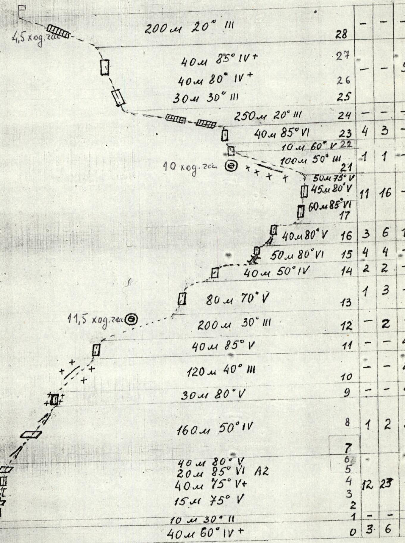
Scale 1:5000
Description of the route by sections
R0–R1 Internal angle. Flowstone in the center. Climbing of medium complexity. Few opportunities for belay. R1–R2 Scree inclined ledge, in the upper part a place for belay. R2–R3 Complex climbing, few reliable holds. Few places for pitons. R3–R4 Chimney narrowing upwards. No places for pitons and chocks. Complex transition to the wall. R4–R5 Climbing of medium complexity, many loose holds, preliminary clearing necessary. R5–R6 Smooth wall with a wide oblique crack. Climbing on underclings, partially on AIDs. R6–R7 Rock wall with a small number of holds. Transition to a couloir filled with ice. Ice thickness insufficient for ice screws. Exit along the right wall of the couloir. R7–R8 Wide scree ledge, further wide scree couloir. Many "live" stones, maximum caution required. R8–R9 Snow-ice ridge. On steep sections, belay through ice screws required. R9–R10 Ice under a thin layer of firn snow. Reliable belay through ice screws. R10–R11 Snow-ice ridge with small cornices. R11–R12 Steep ice slope, in the upper part rock outcrops. When approaching the outcrops, traverse left to the rocky ridge. Complex exit to the rocks. R12–R13 Exit to a wide snow lower shoulder, overnight stop site. R13–R14 Simple ridge with a small rock wall. Passed on the right, holds need to be checked before loading. R14–R15 Rock wall. Rocks heavily destroyed. Belay complicated. R15–R16 Chimney filled with flowstone, plug at the top, belay complicated, complex exit to the rock wall. Small number of small holds, flowstone. Preliminary testing of holds necessary. R16–R17 Traverse of the rock wall to the left to a small snow-ice couloir, belay through an ice screw. Then rock wall with a small overhang at the top. Bypassed on the left. R17–R18 Narrow rocky ridge, in the final part resembling a "knife". R18–R19 Very steep wall. Rocks in the form of "sheep's foreheads", tense climbing, partially on AIDs, belay complicated, required rope extension. R19–R20 Movement left-upwards along a small slab (10 m). Exit to the wall on AIDs. Further system of small cracks of small depth, small chocks go well. At the top, a good place for belay behind a large slab. R20–R21 Complex climbing along rock slabs with change of direction, few convenient holds and places for belay. R21–R22 Simple snow ridge. Convenient overnight stop site. R22–R23 Small rock wall without holds, passed on friction. R23–R24 Complex climbing. Inconvenient holds. Little space for belay. Preliminary testing necessary. R24–R25 Simple ridge with large snow cornices, bypassed on the left. R25–R28 Snow-ice slope with rock outcrops. Reliable belay through ice screws. Exit through a snow cornice. R28–R29 Summit ridge. Belay through ice axes. Summit.
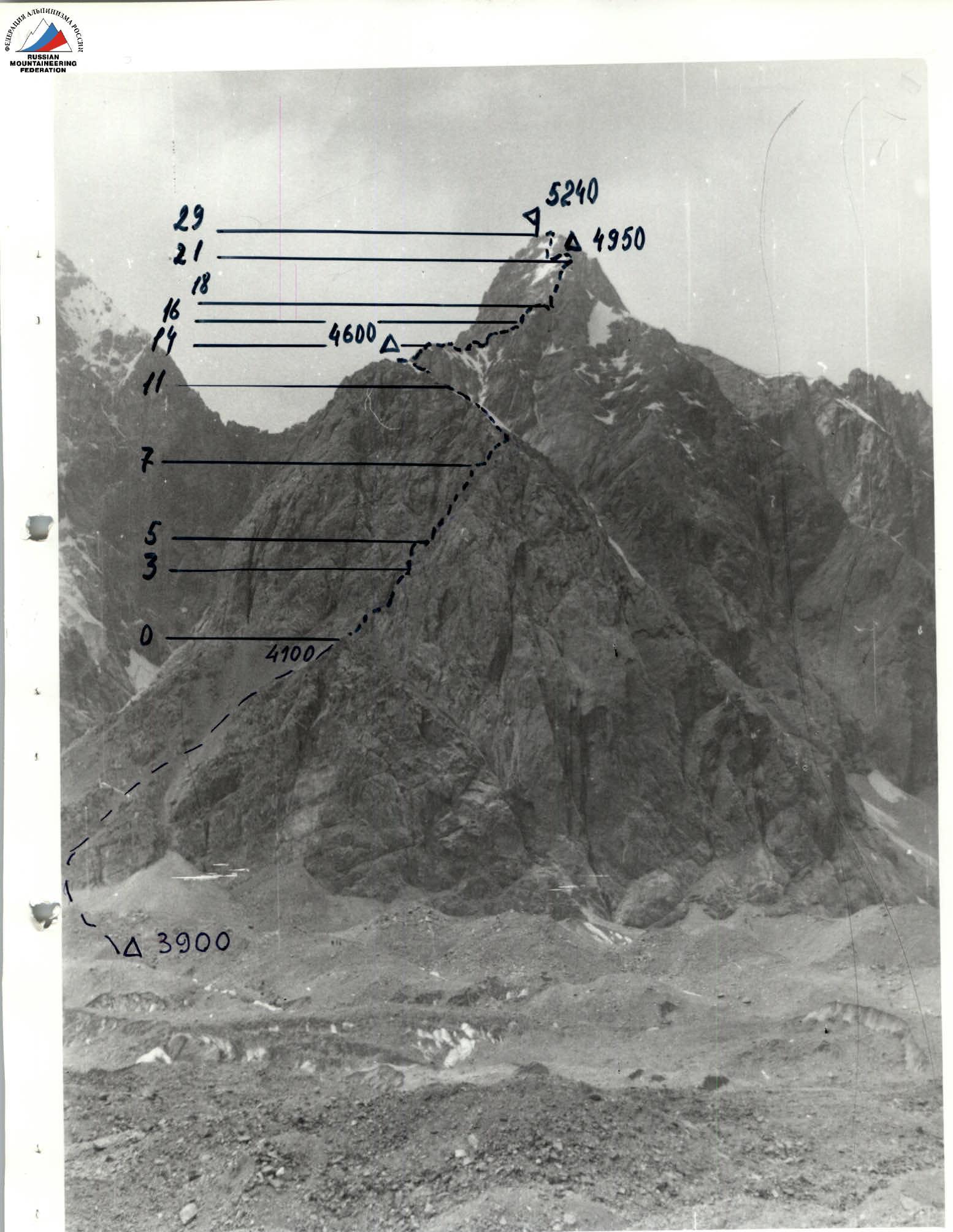
Photo 4. Technical photo of the route. Shot from the "Issledovateley" glacier. September 18, 1996. H = 3800 m, L = 2000 m.

Photo 6. Profile of the route from the left. View from p. Dzholdash. August 25, 1996. H = 5000 m, L = 2000 m.
Comments
Sign in to leave a comment