
Ascent Passport
1. Ascent Class — High-altitude
- Ascent Area — Central Tien Shan, Kokshaal-Too ridge
- Ascent Route — Peak Pobeda Main (7439 m) via 3rd category route, through Peak Pobeda West, from Glacier Zvezdochka
- Complexity Category — 5B–6A, combined
- Route Characteristics:
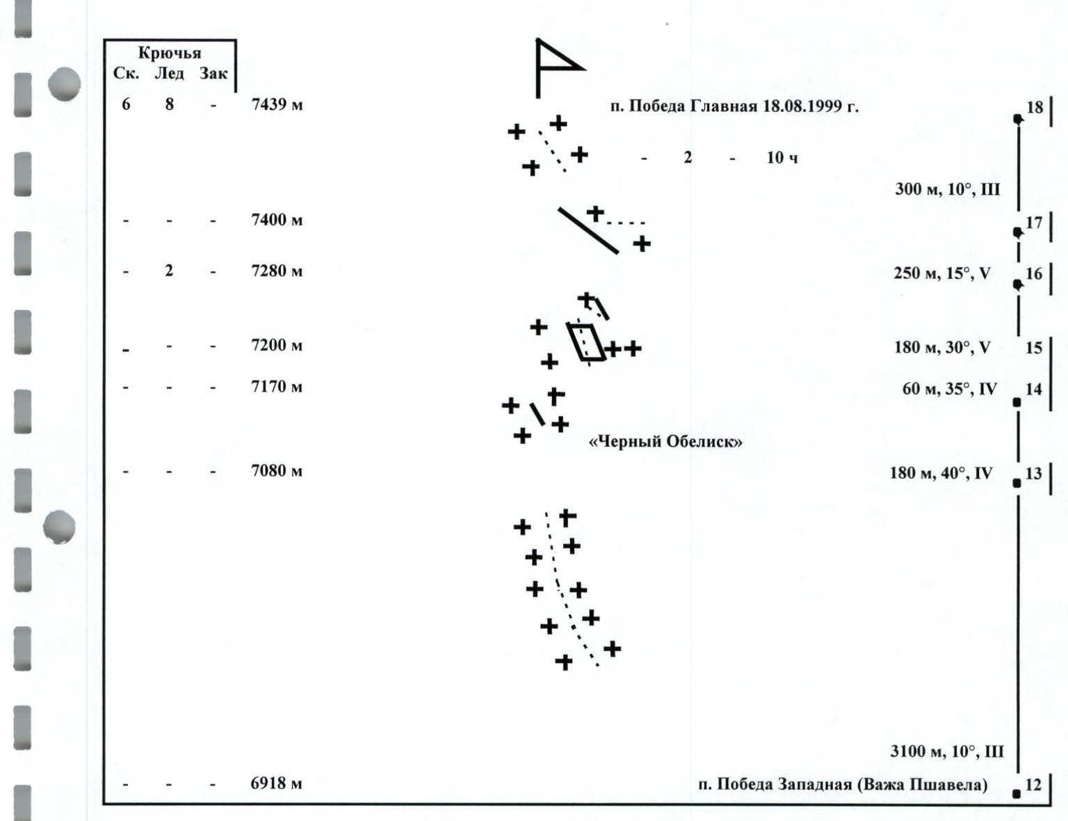
height difference — 3240 m; of which wall section — 980 m; total route length — 8650 m; wall section length — 1450 m; of which 5th category complexity — 1250 m; of which 6th category complexity — 70 m. Average steepness of the main (wall) part of the route is 35°, of the entire route — 22°
- Pitons used: rock — 6, ice — 8, chocks — none, snow anchors — none
- Total climbing hours — 54.5 hours, days — 7
- Number of bivouacs and their characteristics:
total 6 bivouacs:
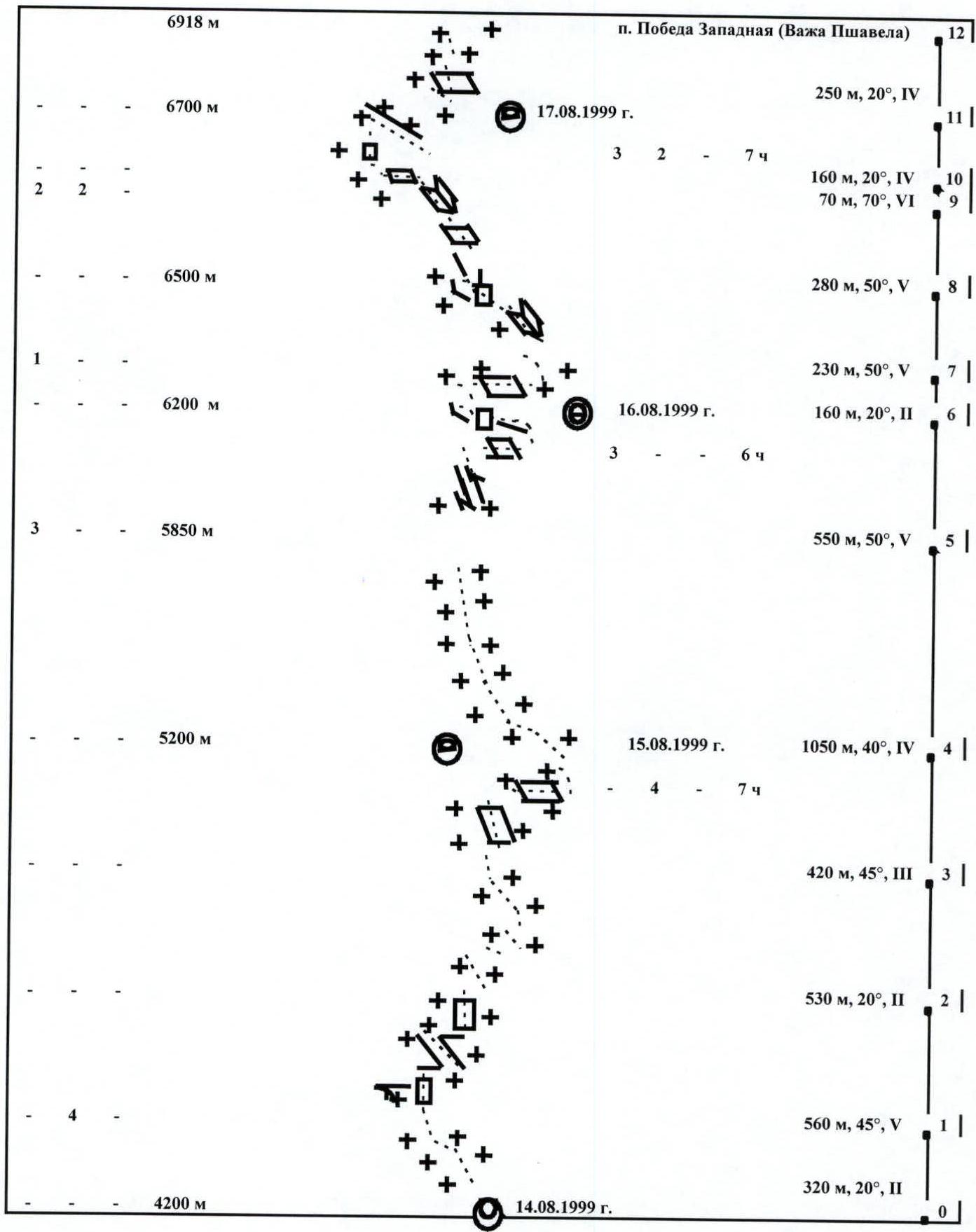
- 1st in a tent (4200 m)
- 2nd in a cave (5250 m)
- 3rd in a tent (6200 m)
- 4th in a tent (6700 m)
- 5th in a tent (7300 m)
- 6th in a tent (6700 m)
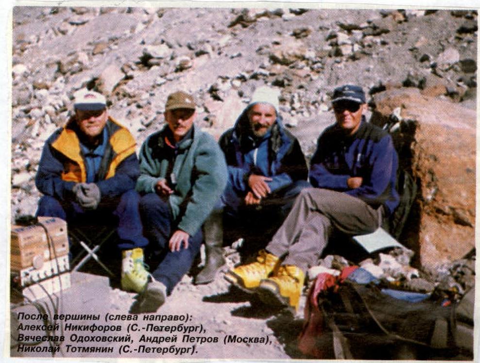
- Group Leader: Petrov Andrey Evgenievich, Candidate Master of Sports.
Group Member: Odokhovsky Vyacheslav Veniaminovich, 1st sports category
Group Observers:
- Totmyanin N.A., Master of Sports
- Nikiforov A.M., Candidate Master of Sports
- Group Coach: Khokhlov Yuri Vladimirovich, Master of Sports
- Departure to the route — August 14, 1999.
Summit — August 18, 1999.
Return — August 20, 1999.
- Organization — Moscow Alpine and Rock Climbing Federation
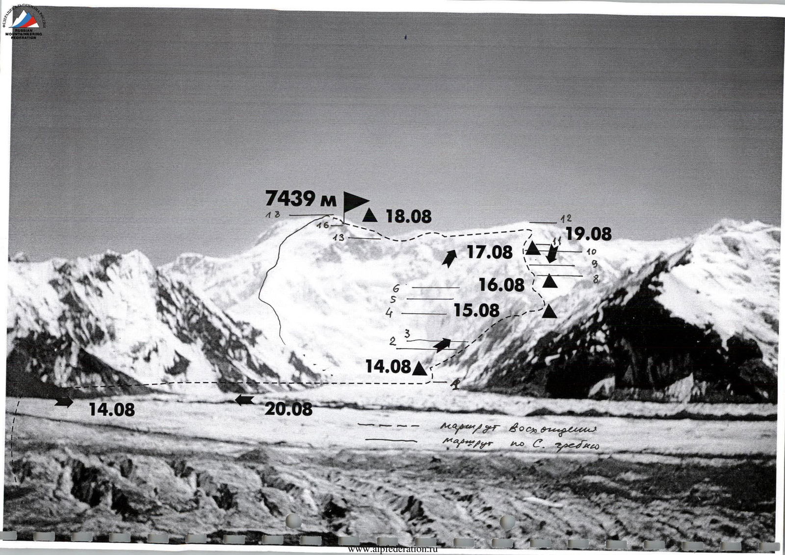
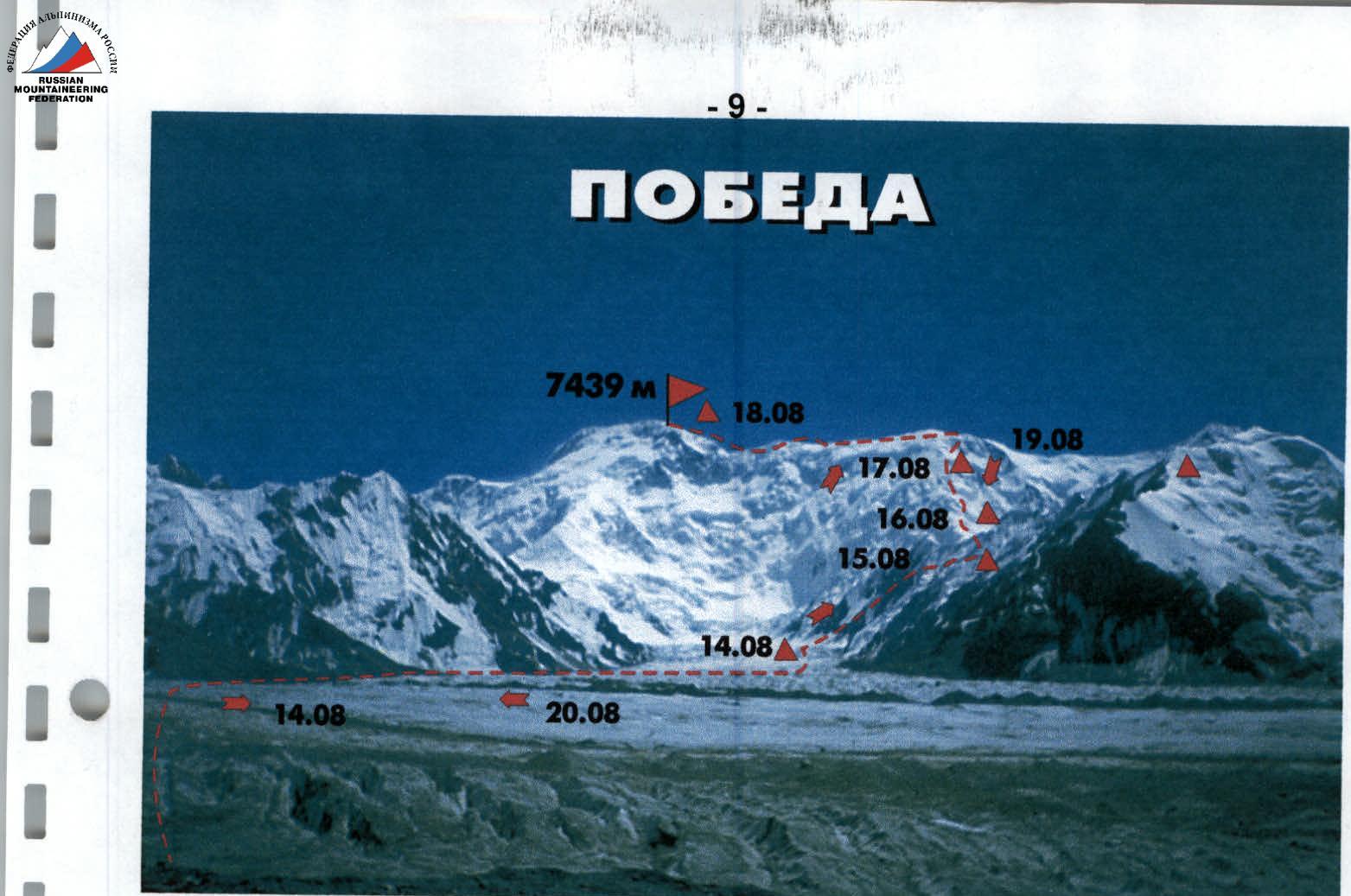
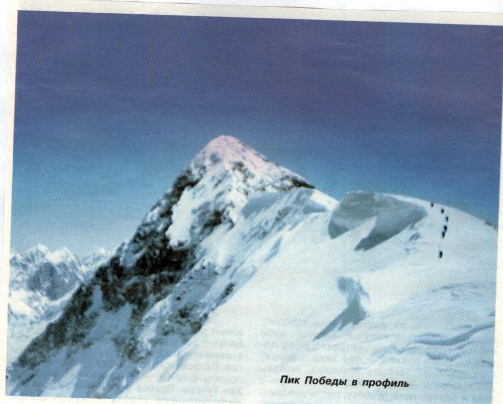
Fig. 2. Photo of the summit showing the ascent route and bivouac locations.
The 4th day according to the tactical plan was supposed to be crucial, as we planned to establish a storm camp (tent) on that day. We decided to choose a site at an altitude of 6700–6900 m for this purpose. If we were in good physical condition, we could ascend to 6900 m; otherwise, or in case of bad weather, we would stop at 6700 m (one of the bivouac locations on this route). On the 5th day of the ascent, we planned to reach the summit of Peak Pobeda Main and then descend according to the group's condition and weather conditions. The possibility of descending directly via the West Ridge was complicated by our observation that in the second half of the day, the entire ridge from the East Summit to the West Summit was usually covered in a layer of clouds, making orientation above 7000 m difficult. Additionally, according to feedback from the group members from Almaty, it snows daily on the ridge during this period, covering the tracks. Thus, we would have to make new tracks. On the 6th day of the ascent, we planned to descend via the West Ridge. The large (rocky) part of the West Ridge was "littered" with old ropes from previous climbers (serving as markers). We had previously descended from an altitude of 5800 m via snow slopes in conditions of zero visibility and covered tracks, which, although difficult, were still traceable under the fresh snow. At critical points, we (and other groups) had previously set up flags. All this led us to conclude that descending via the West Ridge was possible even in bad weather. Taking all the above into account, we expected to descend to the bivouac in the caves (5250 m) on the Diky Pass (in the best case) or to the bivouac in the cave at 5800 m (in the worst case). On the 7th day of the ascent, we planned to descend to the base camp (in the best case) or (in the worst case) to the bivouac in the tent set up on the Zvezdochka Glacier at an altitude of 4200 m.
Ascent Description
Day I. August 14, 1999
Departure from the base camp on the moraine under Peak Gorky at 11:00. Crossed the South Inylchek Glacier in the upper, more gentle part without significant issues, as the rivers were covered by previous days' snowfalls. As we approached the M AL (K. Valiev's camp), a dense snowfall began, which continued until the end of the day. From M AL, the group moved along the right (orographic) morainic part of the Zvezdochka Glacier until the trail transitioned into one of the glacier's tongues. Then the movement continued along the glacier, initially through its central part and then gradually transitioning to its left part under the slopes of the Diky Peak ridge. The condition of the Zvezdochka Glacier was good (almost completely open); nevertheless, the movement was in rope teams due to the numerous crevasses. In the upper part of the Zvezdochka Glacier, the icefall was heavily broken, with open crevasses, and the path through it was potentially hazardous, requiring bridge crossings and detours. At 18:00, the group reached the bivouac site at 4200 m and set up camp in a tent established during the reconnaissance. The tent had been placed far from the icefall for safety reasons — during the icefall processing, one group's (Kazakh) tent had been swept away by an avalanche. The tent had to be dug out as it was buried under snow from previous days' snowfalls. The snowfall ceased by night.
Day II. August 15, 1999
The morning was magnificent. We rose with dawn and set out on the route — we had to pass the icefall before the sun warmed the slopes and rockfall began. After snowfalls, avalanches could occur. The path to the pass through the valley among the slopes was like a "frying pan" where it was hot during the day. We packed the tent into a bag, secured it, marked it with sticks (from now on, we would use ice axes) and left it on the snow. Twenty minutes later, we reached the Iranian camp — there were several tents here. The trail was covered in fluffy snow, but it was easier to walk than during the reconnaissance when we had to make tracks. The section R0–R1 from the bivouac to the beginning of the icefall was traversed in a rope team with simultaneous movement in pairs. About 20 minutes later, we approached the start of the icefall. We put on crampons under the protection of rocks. The sun already illuminated the icefall. We ascended the snowy slope and trod steps in the snow to the beginning of the ropes. Previously, there was ice here. Above, ice walls with enormous blocks of ice, like multi-story buildings, over the snow. We had to rehang one rappel rope in the lower part of the icefall (it was covered in snow and ice from a collapse). The upper part of the icefall remained untouched. As a result, after 2 hours, the pair completely traversed the section R1–R2 (icefall) using alternating movement with the use of rappel ropes and protection via ice screws. Next, a gradual ascent-travel began along the slopes of the Diky Peak ridge, leading to a sort of "plateau" before the Diky Pass. This place resembled the "saucer" on Lenin Peak. The section R2–R3 was traversed in pairs with simultaneous movement. The ascent to the Diky Pass was not particularly difficult or prone to avalanches. Therefore, on the section R3–R4, the pair's movement was entirely autonomous. The group needed about 1 hour to ascend to the pass and approach the caves at an altitude of 5200 m. Here, we rested and had a gas-cooked lunch. During the rest, the weather began to deteriorate, with wind picking up, clouds gathering, and snow starting to fall. This confirmed our observations that the weather worsens in the second half of the day. Therefore, it was decided to bivouac here in the cave dug during the reconnaissance, following the plan, and ascend higher along the ridge the next day to an altitude of 6200–6400 m. On the pass, a group of Spaniards and French with guides from St. Petersburg were resting; the instructor had gone down with a sick Frenchman and they were waiting for his return. Thus, our pair had to make tracks again, as it was during the reconnaissance. Four army climbers from Almaty came from above; they had ascended 5 ropes up from the Obelisk and descended in bad weather, turning back almost from the summit. When they returned, they couldn't see their tracks. Everything was covered and filled in. Snowfall was daily at higher altitudes. We treated the army climbers to tea, and they descended, tied in pairs.
Day III. August 16, 1999
We departed early; there were no tracks on the slope — everything was covered. During the ascent towards the caves (section R4–R5), the weather was excellent. The ridge above the West Summit was shrouded in clouds by noon. The ascent on this section proceeded through deep snow, with occasional covered crevasses. Movement was in a rope team simultaneously, with protection via ice axe. Frequent leader changes were necessary as making tracks was not easy. The last 200 m were a challenging ascent combined with track-making. By 13:00, we reached the caves, climbed into "our" cave, retrieved the supplies, and prepared lunch. The ceiling on the shelf where we slept had sagged significantly. We had to take advantage of the weather and gain altitude. People were still visible below the pass. It seemed we wouldn't be alone. The snow beyond the caves continued to sag. The rocks seemed close, but it took a long time to reach them. Old, thin ropes appeared, serving as a guide. The ascent continued to the right onto a small shoulder, then around a wall. The ascent involved alternating movement with protection. Soon, we reached a ledge. The caves were now below us. Upward, through a rocky throat, old, tattered ropes led. The ridge itself was heavily serrated, with numerous protrusions and remnants of previous climbers' ropes. Climbing was complicated by the fact that the rocks were snow-covered and partially iced. Protection was achieved through numerous ridge protrusions. Gradually, the rocky ridge transitioned into a snowy one, leading to a large snow ledge (altitude 6200 m) — an excellent bivouac site. The pair traversed this section R5–R6 in 2 hours (a good pace). We decided to bivouac. For the day, we gained a kilometer in altitude, similar to the previous day. We spent a long time enjoying the sunset. Clouds from China hung over the horizon but didn't touch the sun. The weather for the next day was expected to be good. In the darkness, the wind began to howl somewhere on the N er u wall. Generally, on the West Ridge, the wind blew constantly along the entire Pobeda massif from Peak N er u to Peak East Pobeda.
Day IV. August 17, 1999
The wind battered the tent all night. It was very cold, and the tent was frosted from the inside. By morning, it had calmed down. The sun shone, and the sky was clear and cloudless. While preparing breakfast, a dusty avalanche went down from N er u — where was the camcorder? The entire day was windy, though not as strongly as at night. We exited the tent at 9:00. The pair moved in a rope team, first simultaneously and then alternately, using ice axe protection. Next, there was a relatively technically simple section R6–R7, transitioning from the snow ledge back to the rocky ridge. Movement here was simultaneous but with leader changes due to the need to make tracks. Section R7–R8 resembled the rocky part traversed the day before. The rocks were snow-covered. There were also many protrusions used for protection. Movement was mostly simultaneous and only occasionally (in rockfall-prone areas) alternate. Old ropes (path markers) were still visible. After a steep ascent, there was a horizontal traverse. Here, there were several ropes, old ones with worn-out sheathing. At the end, a loop was wrapped around a rock, with the end buried in the snow. Upward, a long chimney led to the ridge. Climbing was required here. At the top, a thin rope led to a snowy edge — a "knife" between two precipices. To the left was the icefall, to the right, the Diky Glacier. After the narrow part of the ridge, there was an expansion, with more snow (due to winds). The site was heavily wind-swept and unsuitable for a bivouac. About 100 m further, via quite steep ice under the snow and then along the slope, we reached a large boulder, next to which was an excellent site, protected from the wind on one side. According to our estimates, this was at 6500 m. We had been walking for 2.5 hours from the bivouac at 6200 m. Here, we took a break. Section R8–R9 from the boulder to the beginning of the rocky triangle at an altitude of 6700 m (the key site of the route) was traversed in a rope team simultaneously in 1 hour. Protection was achieved through ridge protrusions. The wind had died down. Section R9–R10 (rocky triangle) was traversed by the pair alternately using piton protection. This was the steepest and most challenging section of the route on the ridge, with snow-covered and iced rocks. Further, the ridge became more gentle. Meanwhile, the wind even picked up. As usual, clouds formed on the ridge, this time right above our heads. Climbing further in the late day was impractical, especially since we had passed the key sections and the path to the summit was open. Higher up on the ridge, there was a good site; we expanded it with a shovel, built a snow wall, and set up the tent. About an hour later, we were in a warm tent, starting to prepare food. After dinner, we discussed plans for the next day:
- If the wind was moderate in the morning, we decided to head for the summit of Peak Pobeda Main.
The pair's condition was good.
Day V. August 18, 1999
The night was calm. The wind died down. It was warm and comfortable to sleep; we rested well. The "Sumitomo" tent proved to be the best option for two people at high altitude. We woke up before dawn. At six, we started to stir. The weather was clear — we had to attempt the summit, although it was far. We packed, had breakfast, and departed at 8:00. Within an hour, we passed the rocky belt and reached a slope without rocks leading to the snowy dome. The long ascent was challenging even on tracks. One step required two to three breaths. The pair traversed section R10–R11 simultaneously. Section R11–R12 was completed by 10:00 — we ascended to the summit of Peak Pobeda West. The dome was snowy, with no tracks. Beyond the dome, along the ridge, we reached a depression, where there was an old cave — a convenient site for a bivouac. Here, we rested and met S. Penzov's group, an old acquaintance from a neighboring base camp, Commissarova. They were the ones ascending behind us. The Spaniards and French were far below. Section R12–R13. Along the ridge, over 3 kilometers long. After a rise to bypass a huge cornice, there was a long descent. There was no trail, and the snow was hard. To the right, a slope descended. Movement was partially with alternate protection. At the end of the descent, the slope transitioned into a wide saddle. We approached the Obelisk around 1 pm. Here, a piercing wind blew. Section R13–R14. Ascent along the slope to the right of the Obelisk. This hundred-meter rocky tower appeared as a black tooth on the ridge from below, hence the name Black Obelisk. Here, it was brown and covered in weathering ribs. Their intricate convex pattern resembled magical script. Section R14–R15. The snowy slope ended in rocks. Altitude 7200 m. Remnants of old ropes indicated the path between the rocks, further to the right. Traverse to the right along the snowy slope and then directly up to the ridge. On the ridge, to the right, then up, under a rock. Behind a snowy edge was a platform under an overhanging rock. A cozy spot, protected from the wind. Section R15–R16. From under the rock onto steep snow and up to the ridge. Ahead was a sharp ridge and wind. Below us, everything was filled with clouds. We crossed a snowy wall on the ridge — to the right, from China, to the left, to Kyrgyzstan. We walked exactly along the border. Below, a steep slope descended into the clouds, into the abyss, towards the Zvezdochka Glacier. Section R16–R17. The ridge narrowed into a sharp "knife," steeply dropping on both sides. On top, it was like walking on a blade. We had to walk on the side. Feet on the right wall, and the ice axe, leaning over the ridge, on the left. Behind us was China, in front of us, beyond the ridge, Kyrgyzstan. Thus, we danced with sidesteps for 150 meters. It felt like an eternity. Then the ridge widened into a gentle slope. Rocks were visible higher up on the slope. Section R17–R18. The top of the dome was the summit. To the right, a rocky ridge from China approached, to the left, the top of a steep snowy ridge from the north was visible. We were at the summit. One step required three to four breaths. We circumvented the rocks. The ascent was over. We filmed with a camcorder. Below, clouds swirled, somewhere near the Obelisk. Soon, they would reach us. It was already 6 pm; less than three hours remained until dark. Behind a black rock, I picked up a white stone with black veins as a memento. There were no emotions. Yes, this was the summit. We found a cairn with a note from the previous group. We descended to the platform under the rock at an altitude of 7300 m and set up for the night. Directly below us were clouds. Around us, the wind howled.
Day VI. August 19, 1999
We rose before dawn. Had a light breakfast and descended. Under the Obelisk, tents from a Spanish and French group were visible. Before us was a long, long ascent — we had to go up again, with the summit already behind us. Below, clouds rose, and when we ascended to the next rise, everything was shrouded, and snow began to fall. We walked a long time along the ridge in conditions of zero visibility and covered tracks. Descended into a depression. Climbed into a cave, made tea. Meanwhile, outside, the wind picked up. We bypassed the dome. Below us was a slope and the glacier. We descended to our platform and set up for the night.
Day VII. August 20, 1999
Early rise. The morning was clear, but very cold and windy. The descent presented no technical difficulties. On gentle sections, we had to make new tracks. When passing key sections of the route, as well as icy sections, movement was alternate, and on the rocky part of the ridge and from 5850 m to the Diky Pass — simultaneous. On the Diky Pass, we took a break. It was already warm here, and in the valley, on the way to the rappel ropes, it was suffocatingly hot. We descended onto the Zvezdochka Glacier without incident, working at a steady, continuous pace. In daylight, we managed to traverse the Zvezdochka Glacier. By 20:00, we returned to the base camp. Two days later, we flew out by helicopter to the settlement Inylchek.
TABLE OF MAIN CHARACTERISTICS of the ascent route to Peak Pobeda Main via the West Ridge:
- Height difference: 3240 m
- Average steepness of the wall section: ~35°
- Average steepness of the entire route: 22°
| Date | Section No. | Average Steepness | Section Length | Relief | Protection | Complexity | Climbing Hours | Rock Pitons | Ice Screws | Chocks | Snow Anchors | Notes |
|---|---|---|---|---|---|---|---|---|---|---|---|---|
| August 14, 1999 | Base camp | 10° | 12.5 km | moraine, glacier | simultaneous | 2 | 7 h | Zvezdochka Glacier broken | ||||
| August 15, 1999 | R0–R1 | 20° | 320 m | snow | simultaneous | 2 | 20 min | |||||
| R1–R2 | 45° | 560 m | ice | piton protection | 5 | 2 h | 4 | |||||
| R2–R3 | 20° | 530 m | snow | simultaneous | 2 | 1.5 h | ||||||
| R3–R4 | 45° | 420 m | snow | simultaneous | 3 | 1 h | Bivouac in a cave | |||||
| August 16, 1999 | R4–R5 | 40° | 1050 m | snowy ridge | simultaneous | 4 | 3 h | 30 min rest | ||||
| R5–R6 | 50° | 550 m | rocky ridge, snow-covered | piton, protrusion | 5 | 3 h | 3 | Bivouac in a tent at 6200 m | ||||
| August 17, 1999 | R6–R7 | 20° | 160 m | Snow ledge | simultaneous | 2 | 30 min | |||||
| R7–R8 | 50° | 230 m | Snowy ridge | piton, protrusion | 5 | 2 h | 1 | 30 min rest | ||||
| R8–R9 | 50° | 280 m | Rocky ridge | simultaneous | 5 | 2 h | ||||||
| R9–R10 | 70° | 70 m | Rocky wall, iced | piton, protrusion | 6 | 1 h | 2 | 2 | key route section | |||
| R10–R11 | 20° | 160 m | Rocky-snowy ridge | simultaneous | 4 | 1 h | Bivouac in a tent at 6700 m | |||||
| August 18, 1999 | R11–R12 | 20° | 250 m | Snowy dome | simultaneous | 4 | 1 h | West Summit | ||||
| R12–R13 | 10° | 3100 m | Snowy ridge | simultaneous | 3 | 3 h | Obelisk | |||||
| R13–R14 | 40° | 180 m | Snowy slope | simultaneous | 4 | 1 h | ||||||
| R14–R15 | 35° | 60 m | Snowy slope | simultaneous | 4 | 1 h | ||||||
| R15–R16 | 30° | 180 m | Snowy ridge | alternate | 5 | 1 h | ||||||
| R16–R17 | 15° | 250 m | Snowy "knife" | alternate | 5 | 2 h | 2 | |||||
| R17–R18 | 10° | 300 m | Snowy slope | simultaneous | 3 | 1 h | Main Summit | |||||
| Total: | Ascent to the summit (from base camp) | 35 h | 6 | 8 | ||||||||
| August 18, 1999 | Descent from the summit via the ascent route | 2.5 h | ||||||||||
| August 19, 1999 | 5 h | |||||||||||
| August 20, 1999 | 12 h | |||||||||||
| Total: | Entire route | 54.5 h | 6 | 8 |
UIAA Route Scheme
Comments
Sign in to leave a comment