PASSPORT
- Climbing category — high-altitude
- Climbing area — central Tian Shan, Kokshaltoo ridge
- Peak Pobeda Main (7439 m) via col 6918
- Category of difficulty: 5B (6A)
- Route description:
height difference — 3239 m, average steepness — 22°, length of sections with 5–6 category of difficulty — 300 m, including:
- 6 category of difficulty — 50 m
- Number of pitons: rock, ice, chocks II, II, 0
- Number of climbing hours to the summit — 21
- 3 bivouacs on the ascent — in snow caves
- Team from the urban mountaineering club "Ritur" St. Petersburg
- Leader: Bernatsky S.I. — Master of Sports
Team members:
- Luganov S.V. — Candidate for Master of Sports
- Kirgirin V.A. — Master of Sports
- Lavrinenko V.V. — Candidate for Master of Sports
- Team coach: Bernatsky S.I. — Master of Sports
- Departure to the route — August 21, 1995 Summit — August 24, 1995 Return — August 27, 1995
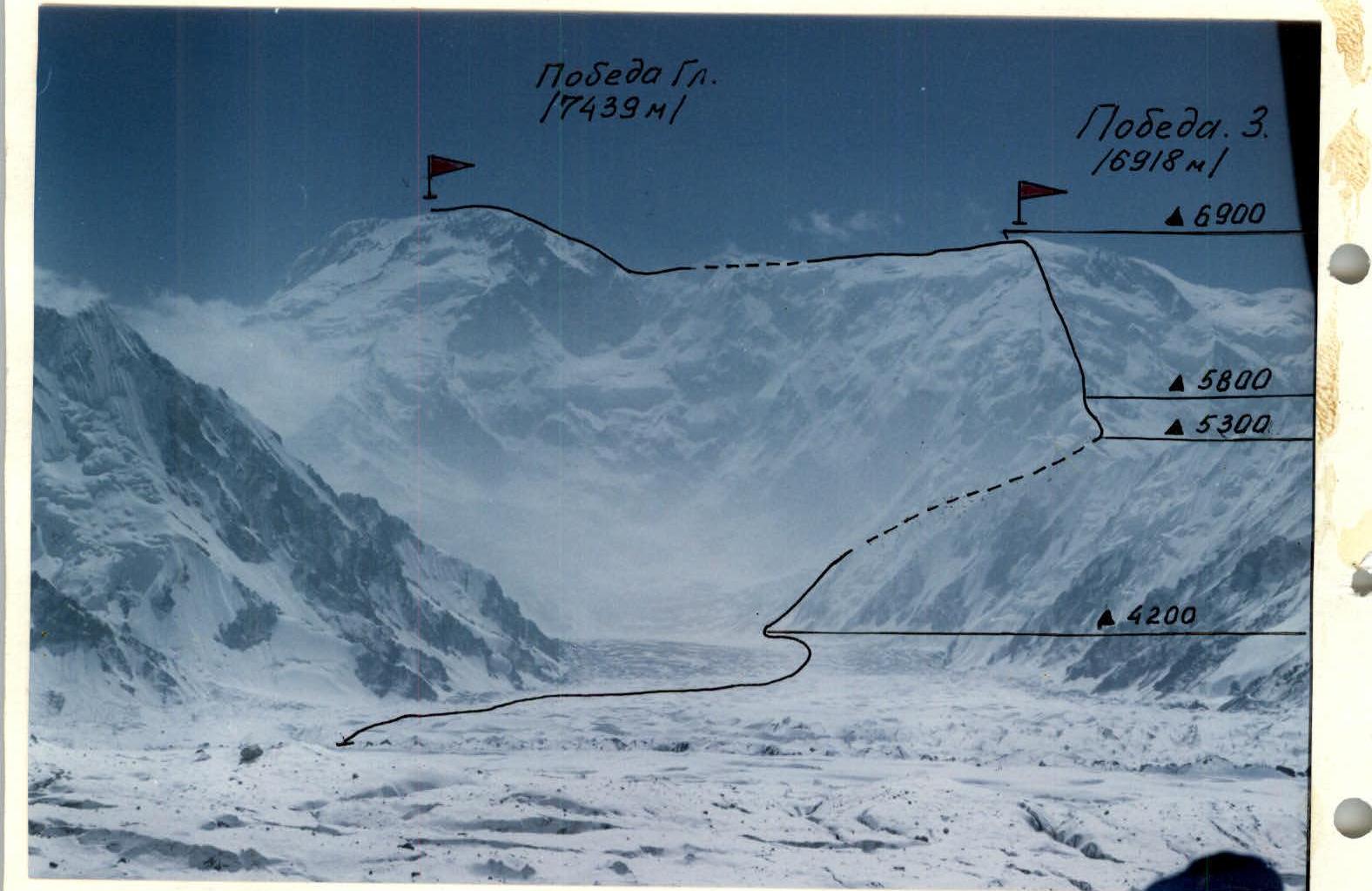
Photo — 1. Date taken — August 17, 1995. Lens: Helios-44. Distance — 8 km. Height — 4000 m.
1 — team's route via 3 gr. through col. Pobeda 3 (6918 m) 5B (6A) category of difficulty.
Panorama of the area.

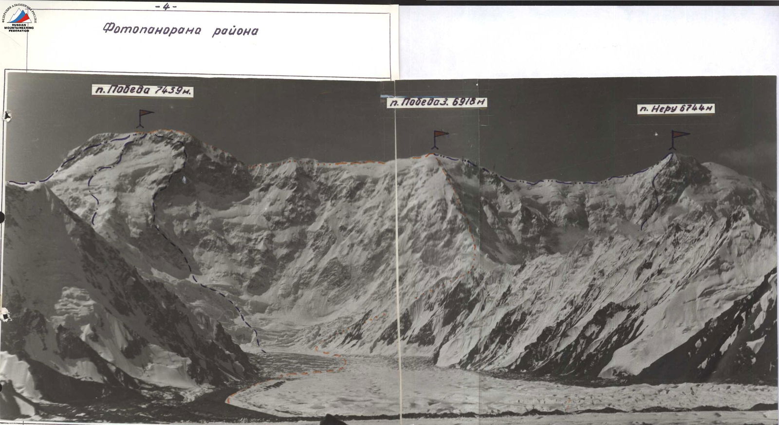
p. Pobeda (7439 m). p. Pobeda 3 (6918 m). p. Neru (6744 m).
Photo #2.
- Abalakova's route from the North, 5B category of difficulty, 1956.
- Erokhin's route from col. Chonteren, 6A category of difficulty, 1958.
- Medzmariashvili's route via 3 gr., 4B/3B (p. Pobeda 3, 6918 m),
- Team's route, 5B/6A category of difficulty, 1961.
- Smirnov's route via S wall, 6B category of difficulty, 1982.
- Ivanov's route, traverse Neru—Pobeda, 6B category of difficulty, 1970.
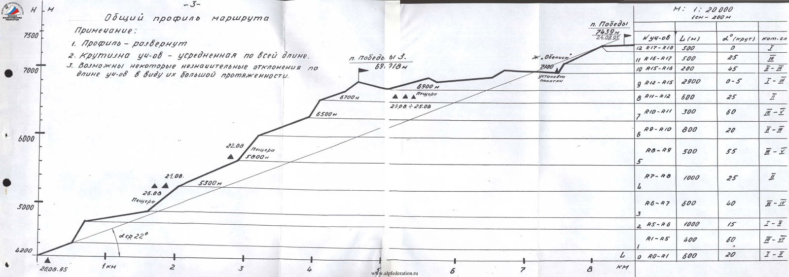
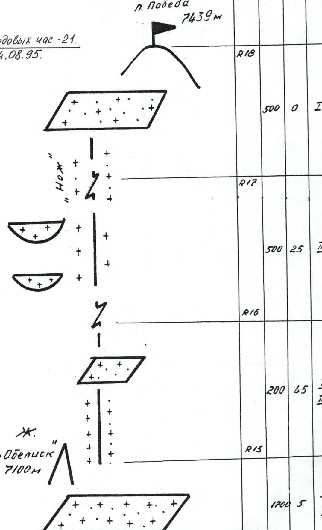
General route profile
Note:
- Profile — unfolded.
- Steepness of sections — averaged over the entire length.
- Some minor deviations in section lengths are possible due to their considerable extent.
p. Pobeda 3 (6918 m). p. Pobeda (7439 m), August 24, 1995.
| Section # | L (m) | α° (steepness) | Category of difficulty |
|---|---|---|---|
| R0–R1 | 600 | 20 | 1–2 |
| R1–R5 | 400 | 60 | 3–4 |
| R5–R6 | 1000 | 15 | 1–2 |
| R6–R7 | 600 | 40 | 3–4 |
| R7–R8 | 1000 | 25 | 2 |
| R8–R9 | 500 | 55 | 3–2 |
| R9–R10 | 800 | 20 | 2–1 |
| R10–R11 | 300 | 60 | 3–5 |
| R11–R12 | 600 | 25 | 2 |
| R12–R15 | 2900 | 0–5 | 1–2 |
| R15–R16 | 200 | 45 | 2–3 |
| R16–R17 | 500 | 25 | 3 |
| R17–R18 | 500 | 0 | 1 |
Gendarme "Obelisk" (7100 m). Tent installation. Cave 6900 m. Cave 6700 m. August 23–25. Cave 5800 m. August 22. Cave 5300 m. August 21. Cave 4200 m. August 20, 1995. Average steepness 22°.
Team's tactical actions
August 20, 1995. According to the tactical plan, after leaving the base camp (4000 m), the team crossed l. Yu. Inylchek, passed l. Zvezdochka, and established a storm camp at the foot of p. Pobeda's slopes by 16:00. Movement across l. Zvezdochka was done in rope teams. Overnight stay.
August 21, 1995. Departure at 8:00. Movement in rope teams: Lavrinenko — Kirgirin, Bernatsky — Luganov (section R0–R1). Transition to the icefall step (section R1–R5). Noticeable strong serac movements and traces of icefalls. Some old belays are either torn or deeply frozen into the ice. The leading rope team, Lavrinenko — Kirgirin, uses almost the entire arsenal of ice climbing techniques. The second rope team moves autonomously, using left-behind ice screws. By 12:00, the icefall is passed. The leaders in both rope teams used two ice tools each. After passing the snow cirque (section R5–R6), the leading rope team, Bernatsky — Luganov, finds a logical ascent route to the northern ridge of p. Pobeda 3, bypassing col "Dikiy", whose approach is hazardous due to hidden crevasses and rifts. On the ascent path, a rather unpleasant traverse of a hard snow-ice slope is encountered, with a small ice overhang in its middle part. Belay via ice axes; organization of rope belays (section R6–R7). Weather deteriorates sharply, with strong gusts of wind. Following the backup plan, they decide to proceed to the snow caves, check their condition, and spend the night.
August 22, 1995. Due to extremely strong winds and heavy cloud cover, the departure is postponed to 12:00. Movement along the northern ridge of p. Pobeda 3 is done autonomously, towards the black "triangle" of rocks of the first rock belt (section R7–R8). Weather does not improve; wind gusts intensify. By 14:00, upon approaching the caves at 5800 m, they decide to stop and spend the night.
August 23, 1995. Departure at 8:00. Start working on the first rock marble belt (section R8–R9). The leading rope team is Luganov — Kirgirin. The belt is heavily destroyed; rock is very hard; rockfall is possible. Rocks are snow-covered; cracks are filled with ice. Difficult to organize belays. Rock pitons (mainly "boxes") are used; natural rock outcrops are utilized when possible. Remnants of old belays are visible but not used.
The belt features quite complex walls and internal corners. Rope teams move autonomously. After passing relatively easy sections R9–R10 (rope team: Kirgirin — Lavrinenko), the team approaches the second rock belt by 11:00. Weather worsens sharply; strong winds; cold. They decide to set up a tent and wait out the bad weather. At 12:00, they resume movement.
Start working on the second rock belt (section R10–R11). The leading rope team is Lavrinenko — Kirgirin. The belt is less destroyed than the first one and steeper. Sufficiently complex sections are encountered throughout. Belays via rock pitons and natural relief. Rope teams move autonomously. The belt ends with a smooth slope, transitioning into a hard snow-ice slope. Ice is very hard; crevasses are present. Rope teams move autonomously. After proceeding further along a fairly simple and wide snow ridge, the team reaches the snow dome of p. Pobeda 3's summit (6918 m). No cairn is found; a "veshka" (marker) is located slightly to the left on the slope.
After traversing along the western ridge and slightly descending onto the northern slopes of p. Pobeda, they enter a wide hollow where they dig another cave for the night (section R12–R13).
August 24, 1995. Departure from the cave at 9:00. According to the tactical plan, they take a high-altitude tent and sufficient food supplies. Movement is autonomous along the main western ridge (section R13–R14). Large cornices are visible to the left of the movement direction. The ridge section is heavily serrated. Further movement proceeds along the more southern (Chinese) side of the ridge. The hard snow-ice slope demands maximum attention from the participants (section R14–R15). By 11:00, upon approaching the gendarme "Obelisk", they set up a tent and proceed onto the main pre-summit ridge. Movement is autonomous (section R15–R16). Further along is the heavily serrated ridge "Knife" with numerous small cornices and overhangs (section R16–R17). By 14:00, after completing the final section (R17–R18), the team reaches the summit of p. Pobeda (7439 m).
The weather holds; they decide to descend to the hollow. By 18:00, after traversing the last meters in complete fog, they arrive near the cave. August 25, 1995. They spend the entire day at the same location. Their task is to monitor the movement of the second team (led by Reznik V.). In case of need, they are to provide backup. August 26, 1995. After radio communication at 12:00, upon seeing the second team and confirming that everything is in order, they receive permission to descend. By 16:00, they are in the caves at 5300 m. August 27, 1995. Early departure at 8:00. By 11:00, they descend onto l. Zvezdochka. At 14:00, they return to the base camp.
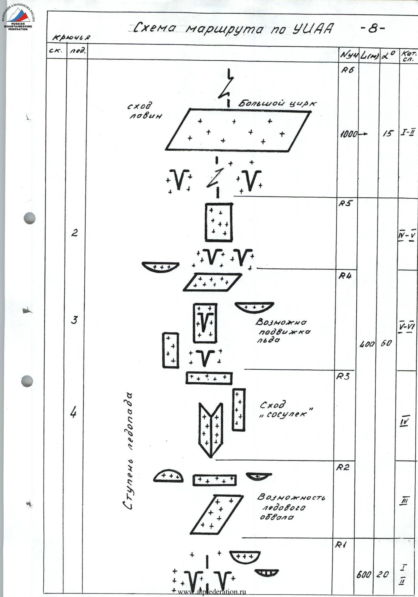
Route diagram according to УЧАА3 section
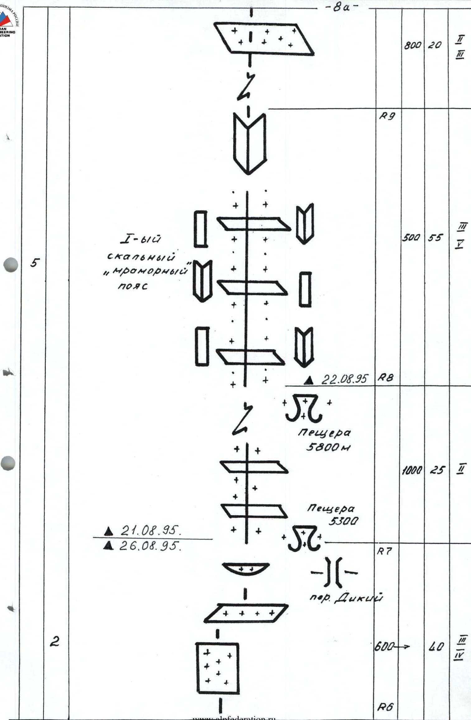


p. Pobeda
7439 m
Route description by sections
Section R0–R1: Relatively simple snow-ice slope with crevasses in the initial part. Objective hazards: icefalls and snow avalanches from the adjacent ridge. The section is best traversed early in the morning. Movement is simultaneous; belay via ice axes.
Section R1–R2: Beginning of the icefall step. Steep ascent along a snow-ice slope under an ice serac. Possible icefall and falling icicles. The entire icefall step is recommended to be traversed early in the morning with crampons. Belay via ice screws.
Section R2–R3: Steep ice internal corner leading to a snow-ice ridge. Belay via ice screws.
Section R3–R4: Congestion of seracs. Movement is carried out along an ice wall; in the middle part, a large crevasse is present. The ice overhang is bypassed on the left. The wall ends with a convenient shelf — the base of the next serac. Movement is alternating; belay via ice screws.
Section R4–R5: From the shelf, through a crevasse, the next ice wall begins, which flattens out in the upper part and smoothly leads into the snow cirque of p. Pobeda's massif. Movement is alternating; belay via ice screws and ice axes. The first climber works with two ice tools, as on section R3–R4.
Section R5–R6: Large snow cirque. Movement proceeds along its middle part towards col "Dikiy" (5300 m). Possible avalanches from the northern slopes of p. Pobeda and the southern slopes of the adjacent ridge. Ascent to the ridge of p. Pobeda 3 (6918 m) is done to the left of col "Dikiy".
Section R6–R7: Traverse of a snow-ice slope to the right and then upwards. Exit onto the main northern ridge of p. Pobeda 3 (6918 m). In the middle part of the traverse, a small ice overhang is present. Belay via ice screw. On the ridge, a snow cave is located (5300 m).
Section R7–R8: Relatively simple snow section of the ridge. Ends with a black "triangle" of the first rock belt. Objective hazards: "boards". Under the rock "triangle", a cave is located (5800 m).
Section R8–R9: First rock belt composed of hard marble rocks. Practically all rock sections of the belt are heavily destroyed, but steep walls and small internal corners are frequently encountered. Rocks are snow-covered and iced. Old belay ropes are sometimes seen. Rope team movement is simultaneous. Belays are organized using:
- natural rock outcrops,
- rock pitons (mainly "boxes"). The belt ends with a steep internal corner. Objective hazards: rockfall.
Section R9–R10: Fairly wide snow ridge abutting a steep snow-ice wall. In the upper part of the wall, a small ice cornice is present. Objective hazards: cornice collapse may trigger a small snow-ice avalanche down the wall. Movement is simultaneous; belay via ice axes. Further, the ridge becomes slightly steeper with numerous rock outcrops.
Section R10–R11: Second rock belt; at its beginning, a fairly convenient spot for an overnight stay is located on a shelf under a steep rock wall with an overhang (6500 m). Movement is done to the left of the wall. The second rock belt is less destroyed and steeper than the first. Climbing is more complex. Various forms of rock relief are encountered. Belays via pitons and outcrops. Old belays are better not used.
Section R11–R12: Snow-ice slope; in some places, ice is quite firm. Exit onto the snow dome of p. Pobeda 3's summit (6918 m).
Section R12–R13: From p. Pobeda 3's summit (6918 m), movement proceeds left along the western main ridge. On the northern slopes of the ridge, a large hollow (snow cave) is located.
Section R13–R14: Heavily serrated snow ridge. Objective hazard: not to drift too far left onto the northern slopes where powerful cornices are located.
Section R14–R15: Hard firn slope of the western ridge; in some places, ice is encountered. Movement proceeds as if along the southern (Chinese) side. Objective hazards:
- losing orientation,
- hard snow formations,
- cornices,
- overhangs. Movement is done in crampons. Belay via ice axes (sometimes face-to-the-slope). Further movement proceeds along the upper part of the ridge towards gendarme "Obelisk". Convenient area for a tent.
Section R15–R16: Hard, fairly steep firn slope; in its upper part, destroyed rocks are present.
Section R16–R17: Heavily serrated, sharp snow-ice ridge "Knife". Cornices and overhangs are frequently encountered, mainly on its left part. Movement is very cautious. Belay via ice axes.
Section R17–R18: Flattening. Wide pre-summit ridge. Numerous rock outcrops. Cairn on rocks.
Photo illustrations of the report

Photo — 4. View of Pobeda summit from the Northwest at a height of 6000 m.
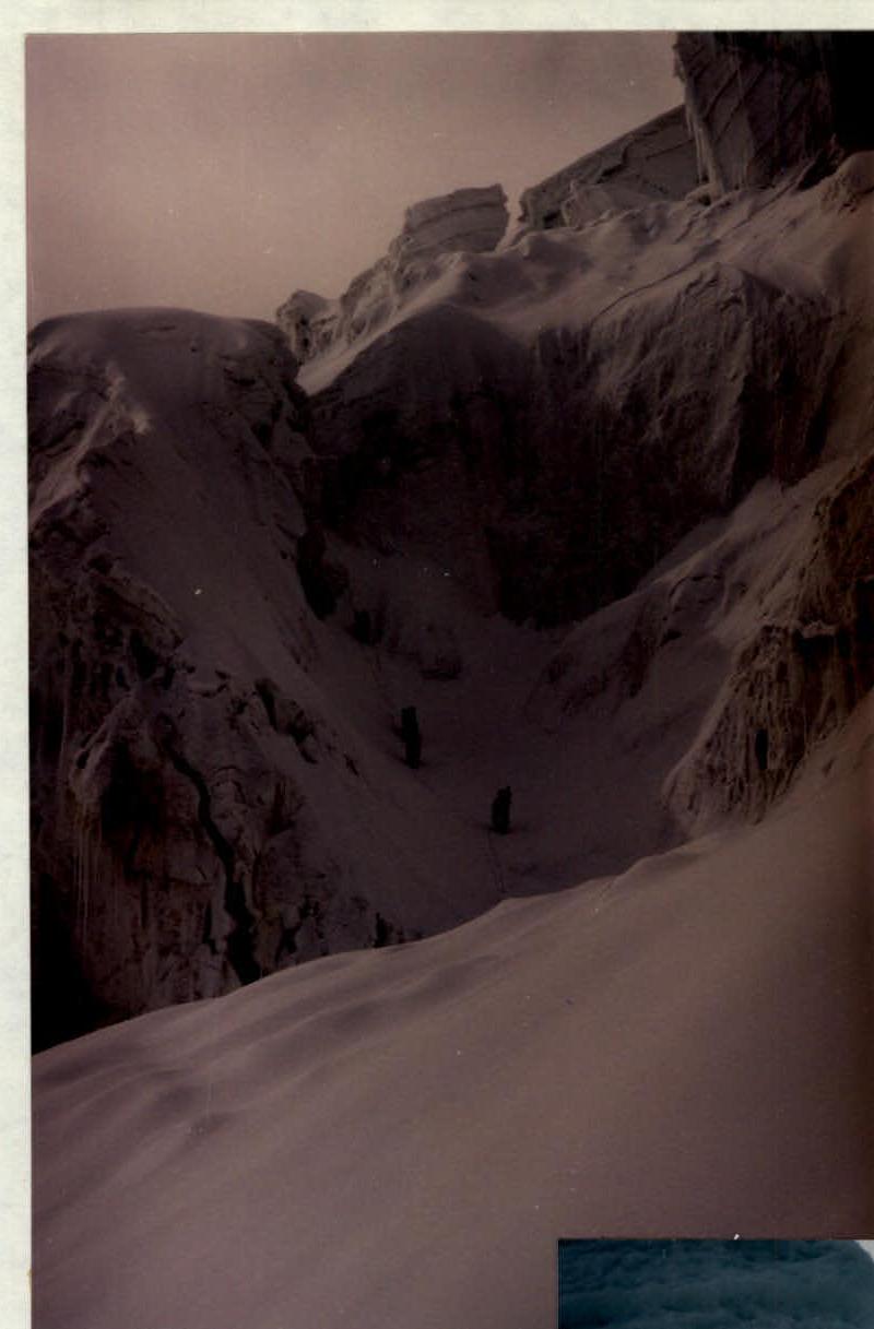
Photo 5. R1–R2. Beginning of the route.
Photo 6. R3–R4. Congestion of seracs.
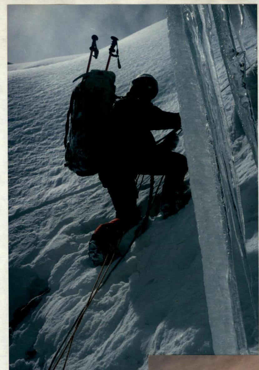
Photo 9. R4–R5. Ice wall before entering the cirque.
Overnight stay (5300 m)!
Photo 10. R5–R6. In the cirque under col "Dikiy".
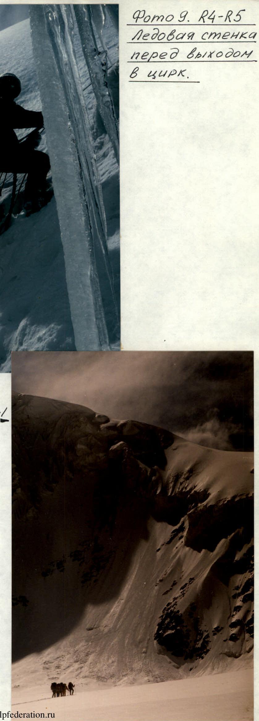
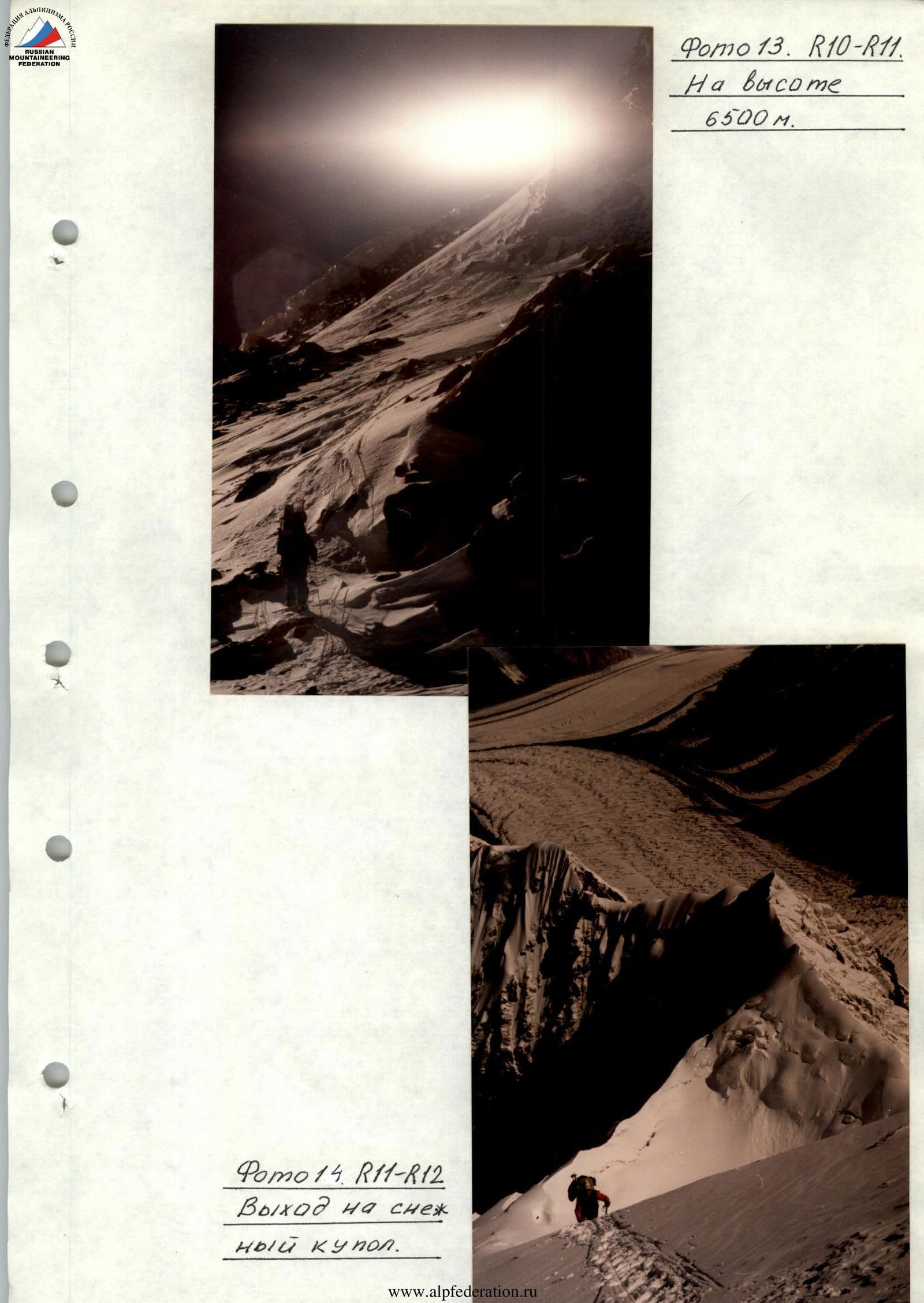
Photo 13. R10–R11. At a height of 6500 m.
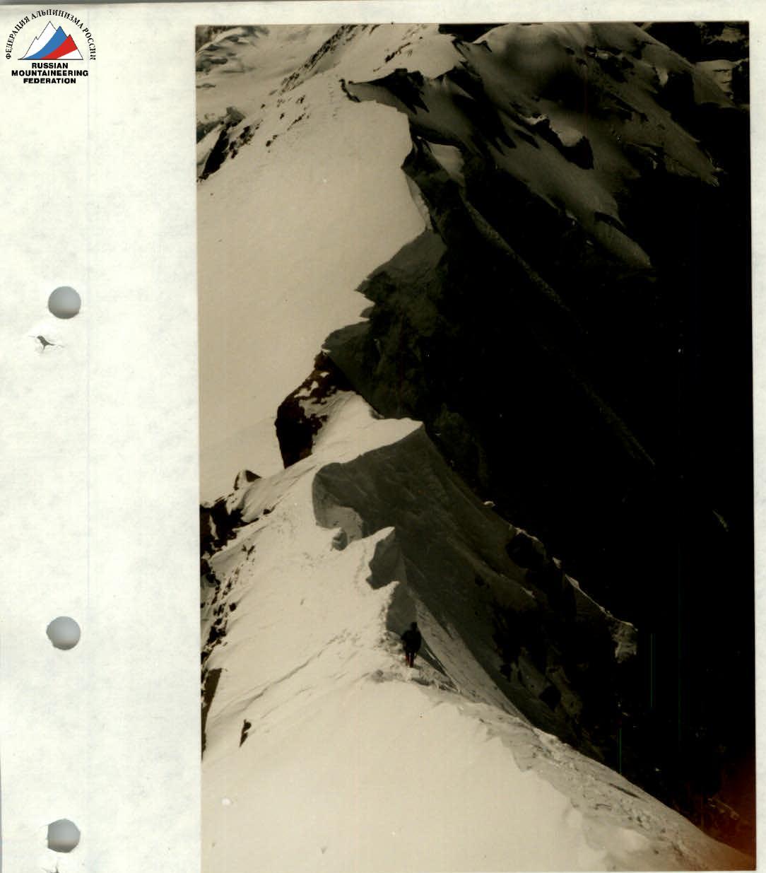
Photo 14. R11–R12. Exit onto the snow dome.
Photo 17. R16–R17. Snow-ice "Knife".
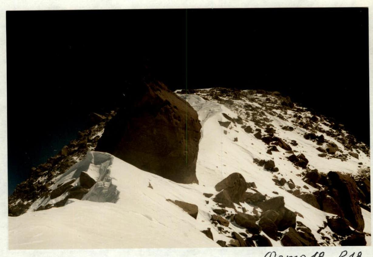
Photo 18. R18. Summit is near.

Photo 19. View from the summit (7439 m) towards China.