Federation of Alpineism of the USSR
1970 Alpinism Championship
Report
on the ascent of Peak Pobeda 7439 m via the Northern ridge (Northeastern edge) by the combined team of CS DSO “Spartak” in the category of high-altitude ascents.
Leningrad 1970
I. Geographical Description and Sporting Characteristics of the Ascent Object
The most southerly and largest ridge of the Soviet Tian Shan is the Kokshaal-Tau ridge, along which the border between the Soviet Union and China runs. The highest section of the ridge, stretching for 115 km, constitutes the massif of Peak Pobeda, the most northerly seven-thousander on Earth (7439 m). To the north of the Chon-Teren pass, the Ak-Tau ridge branches off the Kokshaal-Tau ridge to the northwest, separating the Zvezdochka glacier and the upper reaches of the Inylchek glacier.
The northern slopes of Peak Pobeda rise above the Zvezdochka glacier from the Chon-Teren pass to the Diky pass. They represent a grandiose, almost sheer rock wall with alternating belts of dark and light-colored rocks. Only on individual ledges of the ridges and in the less steep parts of the wall can ice accumulate, forming powerful hanging glaciers from which large sections of ice continually break off, crashing down in enormous avalanches.
In the western part of the wall, six indistinctly expressed counterforts descend steeply downwards, most of which peter out at a high altitude, not reaching the cirque of the glacier below. About ten similar counterforts descend along the eastern part of the wall. The western and eastern counterforts are separated by a long northeastern ice counterfort beginning at the pre-summit ridge of rocks. To the right of it, high on the wall (6400 m), at the lower edge of the summit hanging glacier, begins the only significant Northern ridge of Peak Pobeda. At an altitude of 5900 m, this ridge branches into northwestern and northeastern branches, surrounding a characteristic depression at an altitude of 5300 m, filled with a glacier that descends northwards to the Zvezdochka glacier. The lower part of the ridge protrudes northwards in a gigantic step, forming a kind of pedestal at the foot of Peak Pobeda.
The ascent to Peak Pobeda from the Zvezdochka glacier via the northeastern branch of the Northern ridge was the goal of the Leningrad “Spartak” team participating in the 1970 USSR Alpinism Championship in the category of high-altitude ascents.
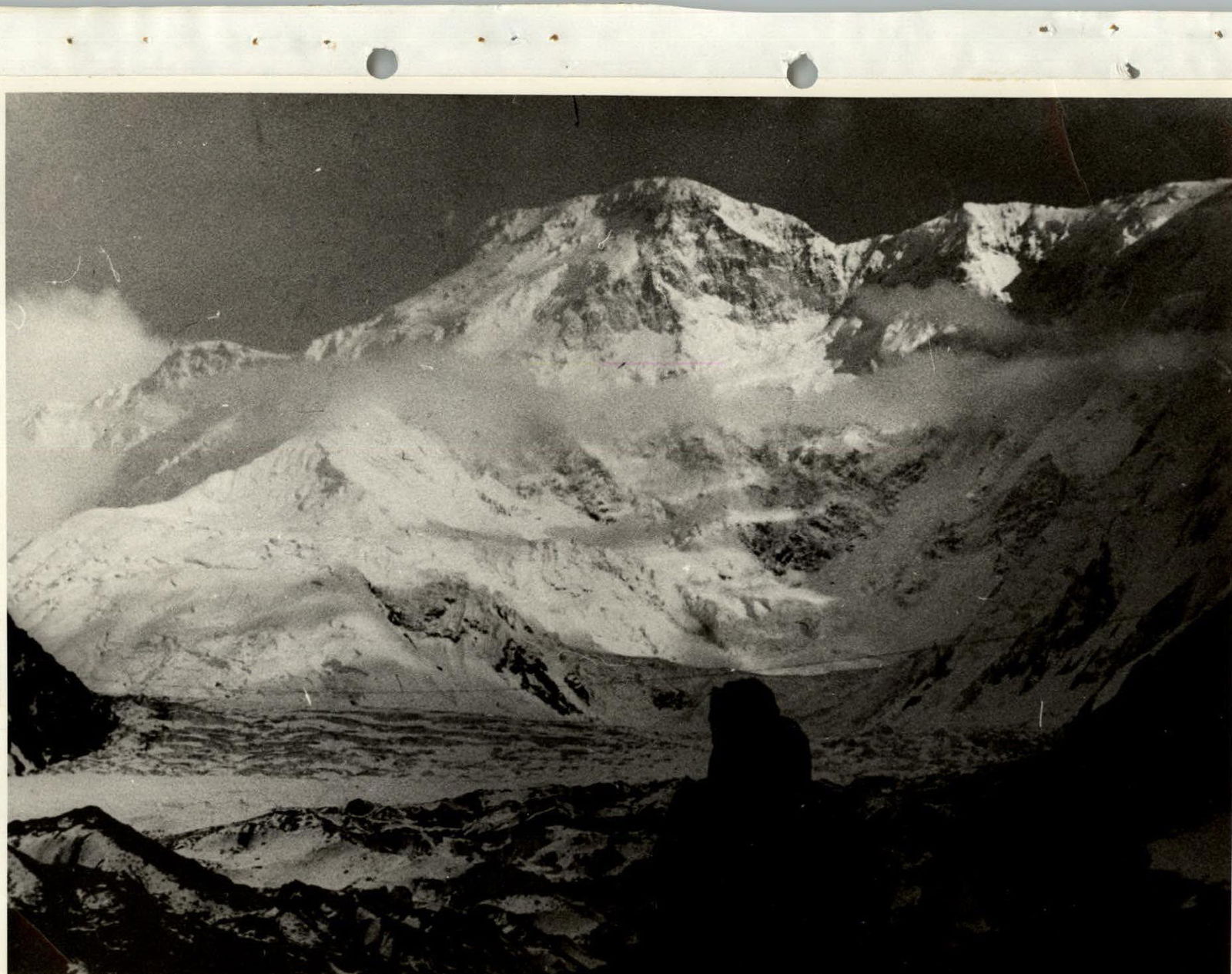
Photo 1. View of Peak Pobeda from the base camp
I. Climbing Conditions on Peak Pobeda
All travelers who have visited Central Tian Shan have noted its harsh climate with very unstable weather. Climbers encounter even harsher conditions on their way to the highest peaks in this region. The page of the sinister biography of Peak Pobeda is a testament to this.
The meteorological conditions in the area are exceptionally harsh, and their forecast is not possible due to the absence of meteorological stations in this region. Frost (exacerbated by high humidity - up to 80%), cloudiness, wind, and snow, as well as a constant avalanche hazard, await the climber at every step. The average annual temperature in the Zvezdochka glacier area has not been measured, but it is lower than that recorded at the Tian Shan meteorological station of the Academy of Sciences (–7.0 °C). The warmest period is July, but even in July at noon, the air temperature does not exceed +1 °C. July also sees the maximum amount of precipitation.
According to literary data, out of 1000 mm of annual precipitation in the upper reaches of the Inylchek glacier:
- 60% falls during the three summer months (or 78 days with precipitation in the summer).
From July 14 to August 22, 1970, there were no more than fifteen days without precipitation.
The area around Peak Pobeda has a unique wind regime due to:
- the enclosed nature of the Zvezdochka glacier from the west, south, and east by high ridges;
- the presence of the highest Tian Shan peak in the upper reaches of the glacier;
- the orographic features of the eastern part of Central Tian Shan;
- the huge accumulation of ice.
At the same time, a mild (up to 5 m/s) wind of local origin is observed in the area, as well as a constant western air flow at altitudes above 5500 m. The speed of these winds often reaches hurricane force.
Sharp changes in snow cover conditions with altitude, weather conditions, time of day, and substrate relief, as well as the duration of stay at high altitude, require constant attention and dictate the work regime. Frequent cloudiness and lack of visibility greatly complicate movement on the large snow and ice spaces of Peak Pobeda.
Taking into account all the above, as well as the experience of their predecessors - all climbers who have ascended Peak Pobeda, the members of the Leningrad team approached the preparation and organization of the expedition very seriously, and above all, to the physical and psychological preparation of all expedition members. All participants, without exception, were required to meet control standards - a criterion for selection to the expedition - and undergo a medical examination at a sports dispensary with increased endurance requirements. There were no people in the main team without high-altitude experience. For everyone, Peak Pobeda was at least the third seven-thousander.
The specifics of the planned ascent dictated the use of specially designed chekhols (bakhils) on woolen socks, spikes on them, felt boots (pai-paki), masks, underhelmets, and careful consideration of all elements of personal and public equipment. The latter included:
- the manufacture of titanium pitons (ice and rock) of several types;
- titanium shovels and saws;
- duralumin tubes (sections for high-altitude tents);
- marking poles for marking the route;
- planning of daily rations and packaging them for “dropping” from a helicopter.
III. Reconnaissance Exits
On July 15, a group consisting of Kletsko B.B., Agranovsky G.L., Roshchin I.N., and Dyakchenko Ya.V. was transported by helicopter to the moraine at 4200 m (the site of the future base camp), from where on July 16, the group set out to the upper reaches of the Zvezdochka glacier with the aim of:
- finding and marking the path to the moraine at 4700 m (the site of the base camp of some previous expeditions);
- further finding and marking the path to the first assault camp (under the beginning of the route - 4800 m).
The assault camp at 4800 m was very successfully located, from which it was possible to constantly observe the routes, both the main one and the alternative variant declared by the team.
The orographic features of the terrain at the assault camp at 4800 m were very convenient for receiving cargo dropped from the helicopter and could even be used, if necessary, as a takeoff and landing strip.
From July 17 to 19, the reconnaissance group conducted visual observations of the route, outlined a possible ascent path, and carried out photo and film shooting of the object. The group had multiple optical instruments at its disposal - binoculars and a spyglass.
On July 20, the base group of participants arrived at camp 4800 m, engaged in transporting cargo, moving to the base camp, and organizing it. Further detailed observation of the route and the beginning of its processing up to an altitude of 5300 m, with the delivery of equipment, supplies, and organization of camp II (5300 m), realistically confirmed the potential avalanche hazard of the route. Upon returning to the base camp, after a wide discussion by the team of the reconnaissance results and consultations with experienced climbers (Kuzmin K.K. and Budanov P.P.), it was decided:
- to abandon the planned route due to its avalanche hazard;
- to ascend Peak Pobeda via the northeastern edge of the Northern ridge (Photo 2).
IV. Strategy and Tactics of the Ascent
The change of route “on the fly” did not alter the strategic plan of the ascent, which was based on the classical principles of high-altitude alpinism:
- Good familiarity with the object before the ascent and thorough preparation for the assault (three Leningrad “Spartak” members participated in the first successful expedition to Peak Pobeda and led the preparation).
- Maximally quick start of work on the route.
- Gradual acclimatization and maximum possible preparation (processing) of the route for the ascent (driving pitons, cutting steps, hanging ropes, digging caves, delivering supplies and necessary equipment, etc.) up to altitudes not lower than 6500 m.
- Maximum improvement of the base camp for good rest.
Tactical features of the ascent were dictated by the situation. Thus, the maximally quick start of work on the route was achieved by:
- helicopter transportation of four scouts from Maydabdir to the Zvezdochka glacier and their foot approach under the edge (acclimatization 4200 m–4700 m–4800 m–5300 m);
- foot transfer of the remaining participants from Maydaodyr to the base camp at 4200 m and, with a three-day break, further to the assault camps at 4800 m and 5300 m on the route;
- helicopter transportation of the base (equipment, supplies, auxiliary property) from Maydaodyr to the moraine at 4200 m;
- cargo drop under the route from a helicopter.
Thanks to this quick start, the decision to change the route, made at the end of the first exit, did not prevent the team from making the ascent to Peak Pobeda via a new path. The result of the first exit was also good acclimatization of the personnel up to an altitude of 5300 m, organization of the assault camp at 4800 m, and close acquaintance of the participants with the unstable weather, the nature, and relief of the northern slopes of Peak Pobeda. This led all participants to a unanimous conclusion:
- the need to mobilize the team's efforts for work on the new route (northeastern variant of the Northern ridge);
- to obtain the maximum possible acclimatization (up to altitudes of 6400–6500 m);
- in all camps, starting from the mark of 5300 m, overnight stays in high-altitude tents should be duplicated by caves.
V. Composition of the Leningrad Part of the Expedition and Assigned Duties
- Budanov P.P. - MSMS - expedition leader, trainer, first release officer.
- Evstifeev L.M. - 1st sports category - head of the expedition's household.
- Melnikov L.V. - 1st sports category - deputy head of the expedition for household affairs.
- Ilyinsky G.Ya. - MSMS - deputy head of the expedition for general matters.
- Kletsko B.B. - MSMS - team captain, second release officer, trainer.
- Roshchin I.N. - CMS - trainer.
- Borisenok O.N. - CMS - deputy captain, compiler of the description.
- Agranovsky G.L. - MSMS - participant, member of the coaching council.
- Ustinov D.K. - MS - participant, compiler of the description.
- Konoplev K.A. - MS - participant.
- Dyakchenko Ya.V. - MS - participant.
- Maerkovich V.V. - CMS - participant.
- Kolchin A.M. - CMS - participant.
- Pepin A.M. - CMS - participant, photographer.
- Zakharenko G.D. - 1st sports category - participant, team doctor.
- Smirnova G.G. - cook.
VIII. Composition of the Ascent Group
On August 10, eight participants set out from the base camp at 4200 m to assault Peak Pobeda:
- Kletsko B.B.
- Borisenok O.N.
- Roshchin I.N.
- Ilyinsky G.Ya.
- Pepin A.M.
- Ustinov D.K.
- Maerkovich V.V.
- Kolchin A.M.

The rope teams were distributed as follows:
- Borisenok O.N. - Roshchin I.N.
- Kletsko B.B. - Ilyinsky G.Ya.
- Pepin A.M. - Ustinov D.K.
- Kolchin A.M. - Maerkovich V.V.
IX. Route Description
During the ascent (and during the first two exits), communication with the base camp was carried out via the “Nedra P” radio station. Throughout the entire expedition and ascent in particular, the communication was stable and reliable. In addition:
- From an altitude of approximately 5400 m, the group on the route was practically always visible through optical instruments from the base camp.
- There was an agreement on light communication using flares in case of necessity.
The teams of the CS “Spartak” expedition from Kabardino-Balkaria and Petropavlovsk-Kamchatsky had completed their ascents by the time the Leningrad team reached the route and formed a rescue team under the leadership of the expedition head, Budanov P.P. The team from Kazakhstan, which was on the traverse of Peak Pobeda at that time and with which there was constant radio communication, acted as a liaison group with the Leningrad team.
August 10. 4:00. The weather is good; we set out from the base camp. A slight frost; the snow on the glacier is in excellent condition. We move quickly, aiming to cover as much distance as possible on the firm crust with minimal effort and energy.
The path from the base camp (4200 m) to the camp (4700 m), found by the reconnaissance group through a terraced steep turn of the glacier, proved to be the most optimal. The Zvezdochka glacier is closed, but moving in the early morning hours, in good snow conditions, and on a marked path - it is not difficult.
At 7:30, we благополучно reached camp 4700 m. A light breakfast and a brief rest. At 8:30, we set out from camp 4700 m.
The first part of the path to camp 4900 m is a practically flat plateau that the group quickly covered on the firm crust. The frost persists, but the rising sun, struggling to break through the cloudiness, begins to soften the snow, and the pace of movement sharply decreases.
The second half of the path to camp 4900 m passes through a glacier torn by crevices and an accumulation of ice seracs and breaks.
At 13:00, the group arrived at camp 4900 m. Lunch.
After lunch, the Ustinov-Maerkovich rope team processes (marks the trail):
- the snow-ice slope up to the ridge;
- further along the ridge to a characteristic ice drop, which is bypassed on the left.
The wind-compacted snow is very dense, and steps are made with difficulty. On the icy sections of the slope (R0–R1), steps are cut during ascent to the ridge, and piton belays are used, while two rocky outcrops at the exit to the ridge (R1–R2, photo 3) are traversed on fixed ropes (2 ropes). The exit to the ridge (R2–R3) - belay via an ice axe. Movement is alternating. Descent downwards. Overnight stay in camp 4900 m in tents.
August 11. Ascent at 7:00. The weather is cloudy, with a slight wind. We set out at 9:00. The Borisenok-Roshchin rope team leads. Progress along the marked trail and fixed ropes on the ridge is quite easy up to the characteristic drop on the ridge (R3–R4). The average steepness of the slope is 50°, and the ridge is 40–45°, with individual steep sections up to 50°. Upon exiting the ridge, belay is provided by pitons and ice axes. Movement along the ridge is predominantly alternating. The characteristic ice drop on the ridge is bypassed on the left along steep snow (45–50°) (R4–R5).
Returning to the ridge along a snow-ice slope, quite steep (50°), the slope is 60–70 m long, steps are cut, and titanium ice pitons hold well in porous, not very strong ice (R5–R6). Snowfall begins. Movement upwards along the ridge between ice drops. The snow is deep, and belay is provided via an ice axe. The average steepness of the upper part of the ridge is about 40° (R6–R7). A steep snow ascent (up to 50°) with an eastern exposure (2 ropes) leads to a platform under a huge drop. This is camp 5300 m. It takes 20 minutes to reach the cave; one needs to descend slightly into the depression. We set up tents under the protection of a huge drop since there is a western wind on the ridge and in the depression, and it is calm here, under the drop. Lunch. After lunch, a brief rest. The weather is good; the snow has stopped; it has cooled down. At 15:00, the Kolchin-Pepin rope team, and an hour later, the Ustinov-Ilyinsky team, set out to process the path for tomorrow. The snow is deep, above the knee, and dry - movement is challenging. For an hour and a half, they move between ice drops (R7–R8), then a steep and long ascent to the ridge, replete with massive cornices to the east (R8–R9, photo 5), along which one must move along the ridge up to an altitude of 6200 m. The ridge is an alternation of ascents and slightly flattening sections of the snow slope. Movement is all the time alternating, with belay via an ice axe (R9–R10). Having reached the rocky wall on the ridge, the group began descending to the tents. A bad weather suddenly set in. A hurricane-force wind with severe frost hindered progress. Visibility was lost. After 15–20 minutes, the half-meter deep tracks of the ascent disappeared. With great difficulty, the group returned to the tents before nightfall. It was relatively calm in the camp.
August 12. The weather is satisfactory. At 8:30, the Roshchin-Borisenok rope team sets out first; it is necessary to tramp the snow again since nothing remains of yesterday's tracks, and it's not even visible where they went. Then the two trios set out in turn. The last to go is the Maerkovich-Kolchin-Ustinov trio, carrying tents that needed to be dried. The rocky wall with a western exposure, which the foursome reached yesterday, is traversed with a slight traverse followed by climbing left upwards and then straight, exiting onto the ridge. The rocks are icy, covered in snow, quite steep, and, unfortunately, monolithic (R10–R11, photo 6). Two rock pitons and three ice pitons driven into the rocks are left for the descent. The wall is about 40 m.
Further, about an hour of movement along the ridge, not very steep (35–40°, R11–R12), then overcoming two steep (R12–R13, photo 7) and very long snow ascents (40°), finally leads to the cave at 5800 m. Movement along the ridge to camp 5800 m is almost entirely alternating; the ridge is steep but safe from avalanches. After lunch, at 16:30, the Ustinov-Kolchin rope team sets out to process the ice slope immediately above the cave, leading to the “triangle vertex” of the Northern ridge. It is snowing, with poor visibility. It is very steep, 70–80°; they have to cut steps, with piton belay. At the top, a rope is fixed (R13–R14); the rope team returns. The well-being of all participants is good; the mood is cheerful. Via communication with the base camp, we learn that the forecast is unfavorable, but we hope that the weather will favor us on this exit.
August 13. Ascent at 6:00. Exit at 8:00. The weather is cloudy, windy, but it's possible to move. Everyone gathers somewhat slowly - the last warm and comfortable cave. The Roshchin-Borisenok rope team goes first - again, they need to tramp the snow. Having passed the ice slope processed yesterday on fixed ropes, the rope team exited onto the actual Northern edge of Peak Pobeda. The path further represents, at first, a ridge with a chain of equally powerful cornices (R14–R15) to the eastern side, with alternating sections:
- Gentle (20–25°)
- Steep ascents (40–45°, R15–R16, photos 8–9)
Moreover:
- On gentle sections, the snow is very deep and loose.
- On steep sections - either very dense snow or firm snow.
Overcoming this section of the ridge is not particularly difficult but requires attentive belay since the lateral steepness of the ridge is significant.
It should be noted that from the cave at 5800 m, the path approximately up to an altitude of 6900–7000 m coincides with the “Spartak” route of 1956. The snowfall continues, and the wind does not cease; movement is challenging, especially on gentle sections, due to loose snow and limited visibility.
“Having passed several steep wall sections with alternating belay, we began digging a cave at an altitude of 6200 m, an hour and a half walk from the ‘black genie’ (R16–R17),” write Ya.G. Arkin and A.U.M. Borovikov, participants in the 1956 ascent.
Our cave is at an altitude of 6500 m, above the mentioned rocky genie. The path to it lies from the flattening at an altitude of 6200 m along a steep snow slope (up to 50°, R17–R18) and a rocky genie blocking the path along the ridge. The genie is traversed on its right side; the rocks are of medium difficulty. The rocks are snow-covered, with belay via ledges and pitons; there are sections with rime ice, totaling about three ropes (R18–R19). Having overcome the genie, we approach the cave of camp 6500 m along a gentle ridge (R19–R20). Despite the dense snow, progress is slow and challenging. Bad weather, strong western wind, cold. 17:00.
August 14. At 9:00, it is comparatively clear all around, but the wind is very strong, cold. The Borisenok-Roshchin rope team sets out first, tied together in the cave, but returns after half an hour - it's very cold; the wind is knocking them off their feet. We wait until 12:00, dressed, fed, and ready to go. We set out during a lull. Initially, from the cave, there is a gentle firn slope (R20–R21), then an ice-firn steep ascent leads to the icefall, which we approach by moving right towards the exit of rocks at the base of the icefall, along the ridge, right up to the wall (R21–R22). The rocks are of medium difficulty, largely covered with rime ice, which significantly complicates their passage. Moreover, the rocks drop off to the west in sheer cliffs.
The icefall is glazed; the ice here is polished to a shine by constant strong winds. The rope team, having processed the icefall, fixed it with ropes (3 ropes of 50 m, R22–R23).
Behind the icefall, the ridge actually disappears; there is a steep firn drop (R23–R24), and then a snow-firn slope begins, leading all the way to the summit rocks (R24–R25). The snow is very hard, compacted by winds; longitudinal sastrugi indicate the direction of the prevailing western wind. The average steepness of the slope is 30°; near crevasses and drops, it's much steeper. We move upwards in the direction of a large genie in the rocky ridge leading to the summit. 6800 m (R25–R26). We set up tents under the slope of a large crevasse and begin digging a cave. The Roshchin-Kletsko rope team sets out to scout the further path. After 2 hours, having come across a large crevasse, we stop digging the cave; however, even in its unfinished state, it duplicates our tents and, in case of bad weather, will serve as a reliable shelter, although not very comfortable. To protect the tents from the strong western wind and snowfalls, we build a wall from large snow bricks, diagonally to the wind, to the northeast. The wall helped a lot - there was a strong wind with snow at night.
The scouts outlined the path for tomorrow: we will not deviate to the left side of the characteristic rocky ridge descending from the summit. In 1956, the “Spartak” team deviated left-upwards, into the lower “gates” of the rocky ridge. Our path is straight up the snowy slope to the right of the rocks. It is planned to exit onto the ridge in its upper part.
We spend the night in tents at an altitude of 6800 m. The well-being, sleep, and appetite of all are normal.
August 15. In the morning, a strong wind complicates an early exit. It's cold; there's a high probability of frostbite. We sit in the tents, ready to go, until 12:00. During a relative lull at 12:20, we set out, moving slowly upwards along the snowy slopes (R26–R27). The steepness increases to 40° (R27–R28). At 16:30, we stop under a rocky drop at an altitude of approximately 7150 m (R28–R29). The rocky ridge is 100 m to our left. We prepare sites for tents. It's steep; there's a lot of work; belay is provided on pitons; fixed ropes are hung. Having prepared the site for tents, we begin digging a cave next to it. The cave turned out to be small since, when expanding it, we encountered ice, and nevertheless, in case of a sharp deterioration in the weather, the cave will insure the overnight stay in tents.
August 16. In the morning, there is a strong wind, frost, but it's clear. We set out at 9:00, moving slowly upwards along the rocky ridge, approaching the base of a large rocky genie (R29–R30), at the level of which we cross the rocky ridge. The rocks are not difficult, strongly weathered and snow-covered, sometimes icy, representing small wall sections of 2–4 m. They are traversed alternately (R30–R31, photo 10). To the left of the rocky ridge, there is a firn-ice slope, along which we begin moving upwards. The slope is steep; sections of firn alternate with open ice. Progress is hindered by a hurricane-force lateral wind and ice outcrops, on which it is necessary to organize piton belay (R31–R32). Gloves cannot be removed; the biting frost is most felt by our photographers.
The slope becomes steeper, turning into a snow-ice ridge (R32–R33), with sections of pure ice and isolated outcrops of rocks, along which we head straight into the cornice of the summit ridge (R33–R34). And now, the first Borisenok-Roshchin rope team, and then the rest, slowly crest the ridge. The summit (R34–R35). A large cairn made of granite fragments is nearby. At the cairn, there is a flattening, and it's calm. These are the southern slopes; before us lies China; we can see far. And behind our backs, snow streams are whipped up to 20 m into the air - on the northern slopes, the wind rages.
We retrieve the note left by the Chelyabinsk “Burevestnik” team (captain Ryabukhin A.), which passed the traverse of Peak Pobeda from east to west before us. The note from the Kazakhstan team (captain Popov V.), which also traversed after Ryabukhin, is left in the left cairn on the summit.
Having rested for about half an hour, we begin our descent. It's already 18:00 - we need to hurry.
The descent proved to be very challenging. The wind blows with the same hurricane force as during the ascent, hitting our faces. Goggles are instantly clogged with snow, and without them, eyes need to be protected from the fierce cutting snow with hands. Icicles constantly form on eyelashes, and removing them is painful. Masks also ice over. It's very cold. It quickly got dark, further slowing down the descent. The last rope team descended into camp 7150 m only at 23:00.
August 17. Exhausted by the previous difficult day, we set out late, at 10:00. The weather is good, although the wind has not completely died down. The mood is better - everyone is eager to descend. We quickly lose altitude, moving without rest; the rope teams rest during belay. Movement is alternating. We pass camp 6800 m, rest for 15 minutes, and continue further. We have passed the icefall; we are at camp 6500 m. The weather is good; the wind is dying down. Without entering the cave, at its entrance, we prepare lunch and rest. After lunch, we continue downwards. We move along the ascent path - almost to the very summit, the path is marked with poles. It's very convenient and pleasant since the ascent tracks are not visible. At 18:00, having passed the cave at 5800 m, we quickly descend along the eastern ridge to camp 5300 m. We spend the night in a comfortable cave. At 5:00 AM, we set out further downwards. The weather is excellent, and the wind is not blowing (incidentally, the weather remained stable for the next four days). Within 3 hours, we are already at camp 4900 m, retrieve the left equipment and some gear, move further to camp 4700 m, and after another 3 hours, we are back at the base camp. Victory! We congratulate each other. And they congratulate us. Victory!
X. Characteristics of the Participants' Actions
The assault group coped with the task excellently. All participants during the ascent acted cohesively and with full dedication. Good physical preparation, acclimatization, and cohesion of all team members brought the team well-deserved success.
The successful ascent of Peak Pobeda is the common success of the Leningrad team. There is no need to emphasize the guiding role of the expedition head, P.P. Budanov. Although he was not with us this time at the top, the success of the entire expedition (all teams completed their tasks) is largely his success. And isn't it Budanov P.P.'s merit to have nurtured a whole team of “lions”? There are quite a few of them now in the Leningrad “Spartak.”
A difficult task fell to Kletsko B.B. Successfully organizing and leading the ascent to the most formidable seven-thousander in the country with a team that had long worked under Budanov P.P.'s leadership - a difficult task.
The team composition also underwent significant changes. The ascent was not participated in by deserving team members: P.P. Budanov, B.B. Kletsko, G.L. Agranovsky, Ya.V. Dyakchenko, K.A. Konoplev. For the first time, V.V. Maerkovich, A.M. Kolchin, and A.M. Pepin were part of the CS “Spartak” combined team. Naturally, the veterans - B.B. Kletsko, I.N. Roshchin, D.K. Ustinov, G.Ya. Ilyinsky, and O.N. Borisenok felt more confident on the ascent.
Those participating for the first time in such events, Maerkovich V.V. and Kolchin A.M., coped with their tasks on the ascent, giving it a lot of strength and energy. The strongest rope team was Roshchin-Borisenok. With this ascent, Roshchin I.N. fulfilled the standard of an international class master of sports (MSMK). Endurance, high technical preparation, and self-control are the most valuable qualities of this duo.
The Kletsko-Ilyinsky-Pepin rope team was distinguished by great climbing experience, calmness in the most critical circumstances, and increased personal responsibility for all team actions.
The Maerkovich-Kolchin-Ustinov rope team bore the greatest physical load on the route and withstood it. Thanks to the combined efforts of all participants, the ascent was made in good style and maximally safely.
XI. Remarks
After a successful ascent of Peak Pobeda via a new variant from the north, the CS “Spartak” team considers it necessary to note some general conditions (recommendations) for a successful ascent of this peak. It is necessary:
- High physical and psychological preparation and technical equipment of the team.
- Overall physical and special high-altitude training.
- Acclimatization above 6000 m.
- Experience of ascending to heights above 7000 m.
- Ability to withstand prolonged physical loads at high altitude in adverse conditions.
Peak Pobeda places special demands on the psychology of a climber (unexpected prolonged bad weather, the need for psychological compatibility among team members, etc.).
Technical equipment implies well-thought-out and fitted personal and public gear:
- Equipped ice axes;
- Crampons;
- High bakhils;
- Gloves;
- Masks;
- Anoraks;
- High-altitude tents of improved design on duralumin poles;
- Marking poles;
- Lightweight (titanium) tools for digging caves;
- Pitons, etc.
XII. Conclusion on the Passed Route
It must be said that the technical complexity of the route turned out to be much higher than previously thought. This primarily concerns the overall steepness of the route and its individual sections. Photographs of the summit taken from a close distance strongly distort the actual steepness of the Northern ridge, apparently due to the overlay of gentle and steep sections, which often follow one another here. Steep sections are characterized by ascents where firn gives way to open ice. Gentle sections, on the other hand, represent traverses along massive cornices on the ridge, the lateral steepness of which reaches 50–60°, significantly complicating the passage of these sections and requiring careful belay.
The entire upper section of the route consists of steep firn ascents with sections of pure ice, where steps must be cut, and rocky walls covered in firn and ice. All this at high altitude greatly complicates the ascent. The entire ascent is further complicated by:
- Constant strong (at times hurricane-force) lateral wind;
- Frequent bad weather.
The team believes that the route they passed favorably differs from the usual one.
A well-defined ridge up to an altitude of 5900 m is technically more interesting (snow, ice, rocks).
Without reducing the tension of the route to Peak Pobeda from the north, the new variant introduces diversity into the heavy snow work on the Northern ridge.
The main advantage of the new variant is its avalanche safety.
The general, unanimous assessment of the difficulty of the route passed by the team is the highest, category 6B.
To the Classification Commission of the USSR Alpinism Federation
On August 16, 1970, the team of LGS DSO “SPARTAK,” as part of the CS “SPARTAK” expedition, made an ascent to Peak Pobeda, with an ascent via a new variant up to an altitude of 5900 m and further along the path of the first ascenders - the northeastern edge of the Northern ridge.
The section of the route from 5900 m to 6900 m completely coincided, and then the team ascended again via a new variant to the summit.
Having experience in high-altitude ascents, such as:
- Peak Communism via the southwestern ridge - category 6B;
- traverse of Peaks Znamensky-Marx - category 6B;
- Peak Korzhenevskaya via the southern ridge;
- Peak Lenin from all sides
the team leader and participants consider it necessary to inform the commission of the following:
The route passed by the team, largely via a new path, although technically more complex than the path of the first ascenders (V. Abalakov), is nevertheless preferable and expedient since the route is safe from avalanches. The team proposes recommending the new ascent variant as the classic path to Peak Pobeda from the north.
In the team's opinion, the path of the first ascenders is classified as category 5B, a part of which coincided with the route of the LGS DSO “SPARTAK” team; this classification is underestimated and should be revised to the highest category - 6B.
The team is also convinced that all paths to Peak Pobeda (and there are four of them) are routes of the highest category 6B.
In connection with the above, the team proposes classifying the route they passed as category 6B.
Senior coach of the team: /P.P. Budanov/ Team captain: /B.B. Kletsko/
Table of Basic Route Characteristics
![img-4.jpeg]({"width":2825,"height":2379,"format":"Jpeg","uri":"https://summit↗