
2014 Russian Alpinism Championship
High-altitude technical class
Report on the ascent of the Moscow Federation of Alpinism and Climbing team to Kyzyl-Asker peak (5842 m) via the center of the Southeast wall "War and Peace," first ascent, approximately 6B category.
Senior coach: Kuznetsova E.V. Team leader: Nilov S.A. Moscow 2014
Kyzyl-Asker via the center of the Southeast wall "War and Peace"
Ascent Details
- Ascent class: high-altitude technical
- Ascent region: Tian Shan, Western Kok-Shaal-Too
- Peak, its height, ascent route: Kyzyl-Asker (5842 m) via the center of the SE wall, "War and Peace"
- Category of difficulty: 6B (first ascent)
- Route characteristics:
| Length | route: | 1351 m |
| wall part: | 1086 m | |
| sections of V–VI cat. | 1056 m | |
| Height difference | route: | 1153 m |
| wall part: | 1015 m | |
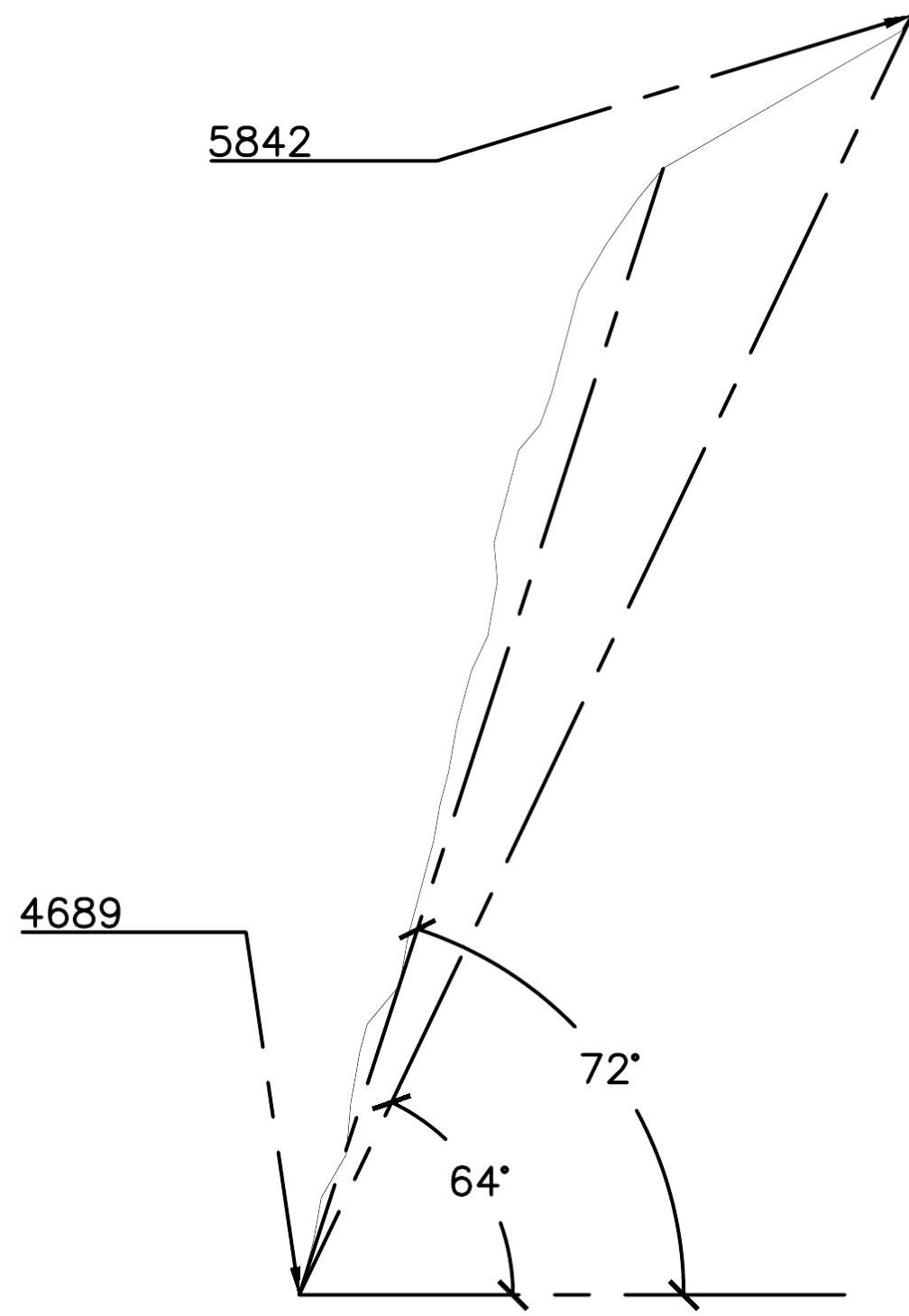
| Average steepness | route: | 64° |
| wall part: | 72° |
- Hooks left on the route (including pitons): 22 (20)
- Team leader: Nilov Sergey — Master of Sports
Team members:
- Grigoryev Dmitry — 1st sports category
- Golovchenko Dmitry — Candidate Master of Sports
- Team coach: Kuznetsova E. V.
- Departure from base camp: August 1, 2014
Summit ascent: August 11, 2014 Return to base camp: August 12, 2014
- Demchenko CSKA, Moscow
Technical photo with the ascent route thread
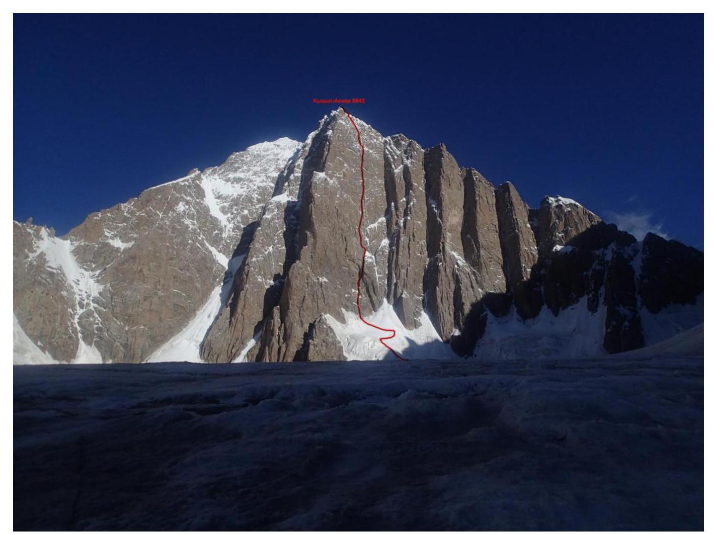
General photo of Kyzyl-Asker peak from the south and the team's route thread
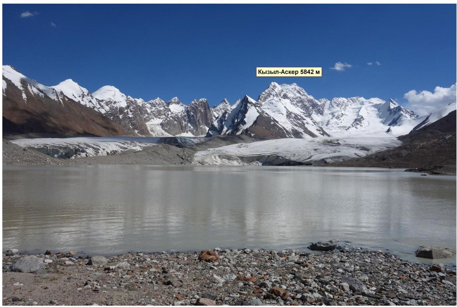
Panoramic photo of the area from the north
Russian Championship. High-altitude technical class. 2014
Area overview
The area has numerous peaks around 6000 m. The most interesting among them are: Kyzyl-Asker peak (5842 m), Krylya Sovetov peak (5800 m), Shmidt peak (5954 m, unclimbed), Dankov peak (5982 m), Chon-Turasu or Joldash peak (5729 m), Alpinist peak (5641 m), Sergey Korolev peak (5816 m). The area is characterized by a mix of typically Alpine forms (numerous vertical rock walls with a height difference of about 1.5–2 km) and vast glaciation, second only to the Pobeda peak area in Tian Shan. The entire area, including lowlands, is a permafrost zone. Marshy areas are common up to elevations of 4000 m.
The snow line is at an altitude of about 4000–4500 m above sea level. River valleys have a high absolute height of about 3000–3500 m above sea level. The climate in the valley is harsh. The average monthly temperature in summer is around 5–8 °C, with unstable weather.
Kyzyl-Asker translates from Kyrgyz as "Red Army Soldier." The first ascent of this mountain was made by K. Valiev's team in 1985. The legendary team ascended the mountain via the northwest wall during the USSR Alpinism Championship in the high-altitude technical class and ultimately ranked 4th.
There are records of 6 ascents to this peak:
- 1985 — first ascent by Valiev's team
- 2004 — Pete Benson and Matt Halls ascended via a new route, starting from the south through the couloir between Kyzyl-Asker and Panfilovskaya Divizia peak
- 2007 — the team of Odintsov – Ruchkin – Mikhailov passed the most beautiful line to the summit, ascending via the central buttress of the SE wall
- 2013 — repetition of the route via the central buttress of the SE wall by a Franco-Belgian team
- 2014 — first ascent by the Moscow team via the center of the SE wall
- 2014 — first ascent by an Ecuadorian team via the second buttress of the SE wall
Additionally, there are records of at least 6 unsuccessful attempts at first ascents.
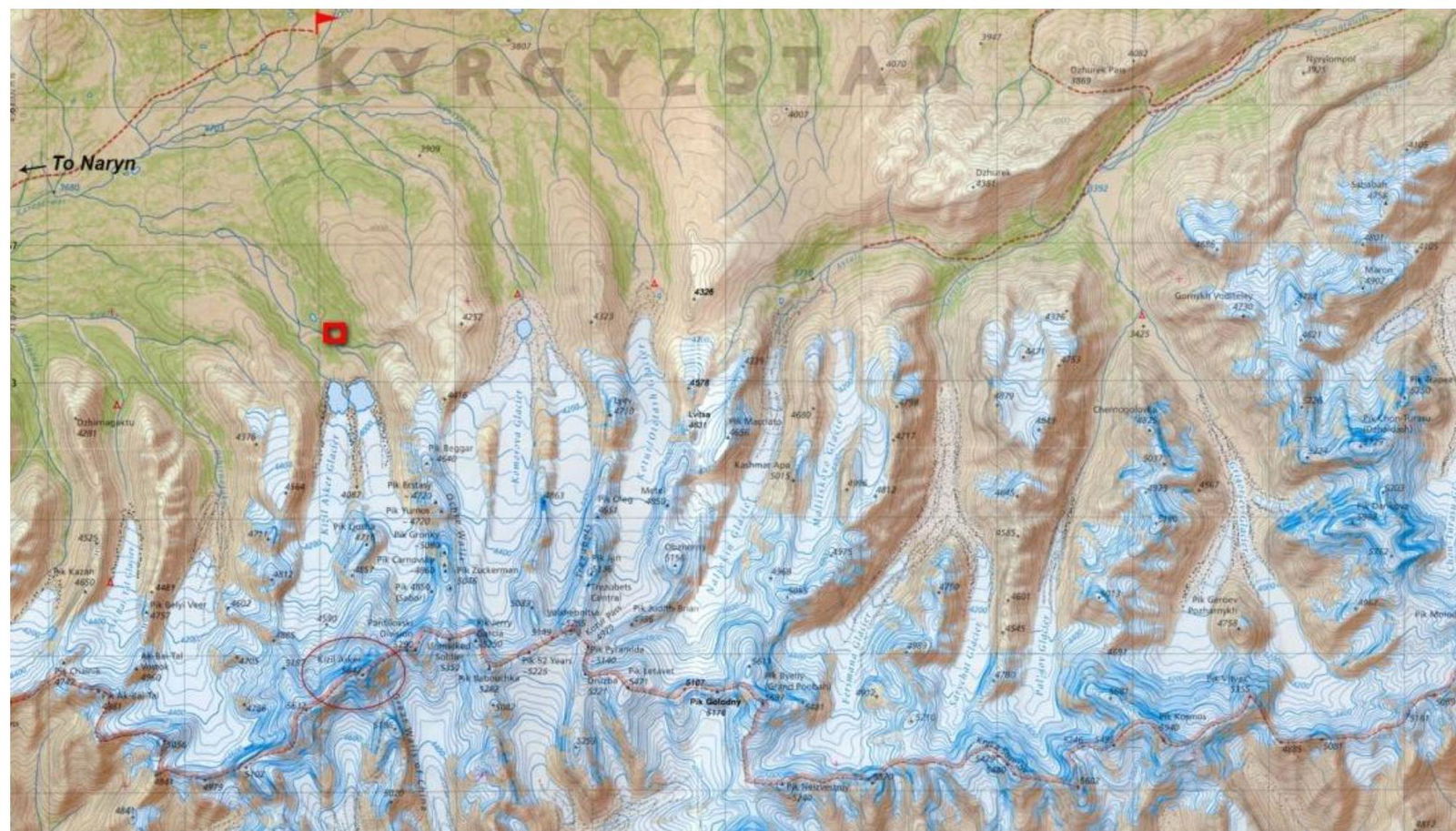
Area map
Russian Championship. High-altitude technical class. 2014
Team's tactical actions
The area is high-altitude, with the base camp located at 3800 m. The nearest peaks/hills are above 4000 m. For acclimatization, we initially walked around the surroundings, setting up cairns on all points that resembled peaks — "someone was here!" We were unable to cross the river to the western ridge, and on the eastern ridges, wherever we reached, we set up cairns. The nearest peak to the camp had a cairn from previous expeditions.
For the main acclimatization ascent, we chose a traverse of the eastern ridge across three (as it seemed from the camp) nice snowy peaks. If not for the bad rappels from the third peak (it turned out there were 4 peaks, and from the camp, the two middle peaks merged), it would have been an excellent route for beginners — all walking and safe. The difficulty and height gradually increase, and the route is snowy (except for the rappel down the rocks from the third peak). The peak Bolshaya Belaya (Gronky peak), the 4th peak, is 5050 m high. The starting point of the route can be considered the base camp tent, as you start ascending the ridge right from it. We took three days, with one day for descent. On the first day after lunch, there was bad weather; the other days had excellent weather. In total, we had 3 nights above 4500 m and gained altitude up to 5000+ m.
We deliberately descended from the acclimatization ascent to Komarov Glacier, where we left the necessary equipment for Kyzyl-Asker. After that, through a simple pass, we returned to the base camp. 2 days of rest and helped us prepare for the ascent. We then moved with full backpacks to our cache. It wasn't possible to cover the distance with all the equipment in one day, so we had to leave some of the equipment on the glacier. The team used snowshoes, which made it easy to traverse the closed glacier. The next day, we returned for the remaining equipment and headed to ABC under the SE wall of Kyzyl-Asker.
The team used 5 x 50-meter ropes: 3 static and 2 dynamic. On the route, we actively used ice tools and ice screws (lower and upper parts), rock climbing equipment: anchor hooks, fifi hooks, nuts, and friends.
Ascent schedule
| Date | Weather | Precipitation | Temperature day / night | Sections covered | Camping site |
|---|---|---|---|---|---|
| 1.08 | Sunny | - | +10 / –5 | R1, R2 | ABC |
| 2.08 | Variable cloudiness | Light snow at night | +10 / –7 | R3–R7 | Camp-1 |
| 3.08 | Variable cloudiness | Light snow at night | +2 / –10 | R8, R9 | Camp-1 |
| 4.08 | Variable cloudiness | Snow | +1 / –10 | - | Camp-1 |
| 5.08 | Variable cloudiness | Snow | +5 / –15 | R10, R11 | Camp-2 |
| 6.08 | Sunny | - | +8 / –15 | R12, R13 | Camp-2 |
| 7.08 | Variable cloudiness | Snow | +7 / –20 | R14, R15 | Camp-3 |
| 8.08 | Variable cloudiness | Snow | +7 / –20 | R16, R17 | Camp-3 |
| 9.08 | Cloudy | Snow | –15 / –25 | R18–R20 | Camp-4 |
| 10.08 | Variable cloudiness | Light snow at night | –5 / –20 | R19–R25 | Camp-4 |
| 11.08 | Variable cloudiness | Snow | –2 / –20 | R26–R28 | Camp-4 – Camp-1 |
| 12.08 | Variable cloudiness | Thunderstorm / snow | +10 / –5 | Descent | BC |
Hand-drawn profile of the route
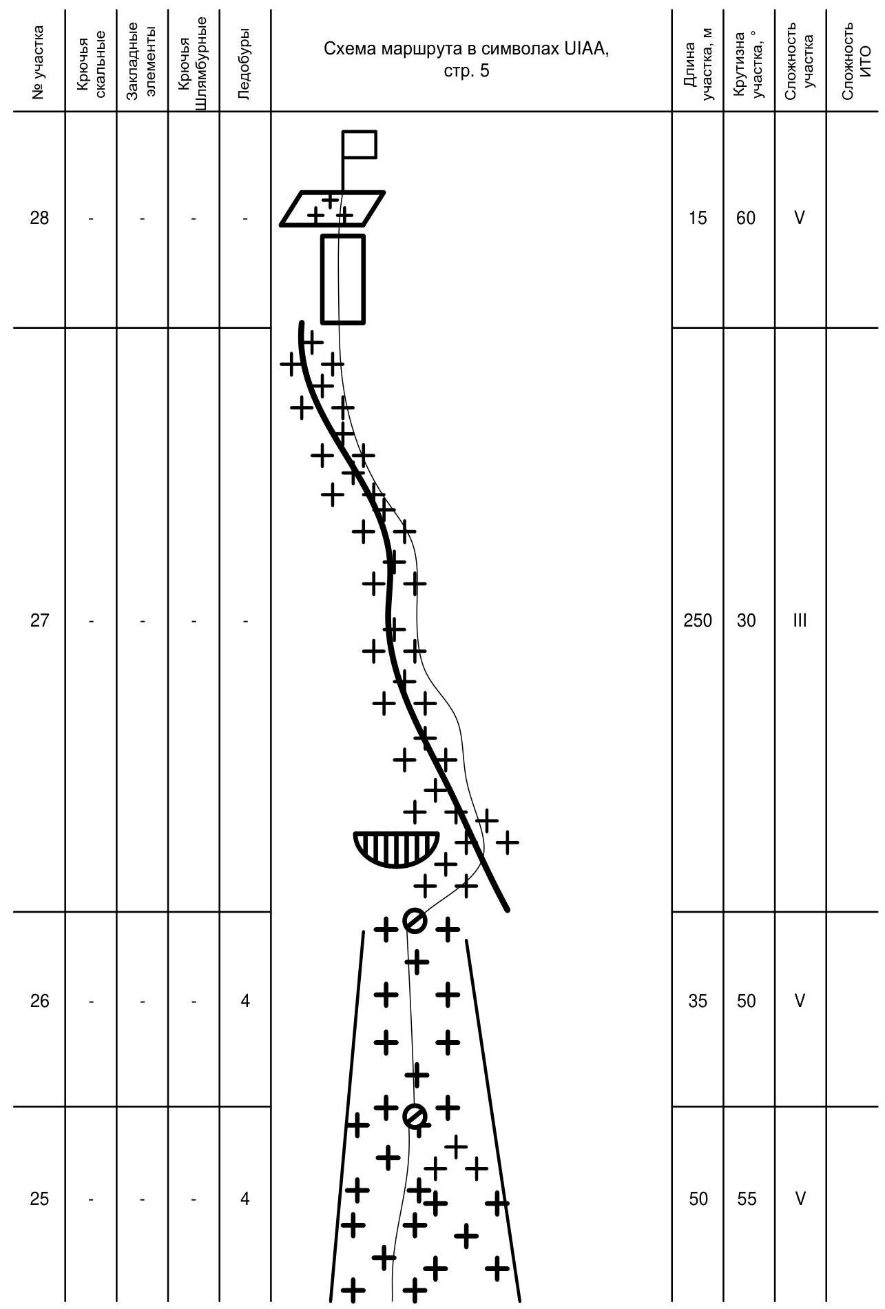
Route diagram in UIAA symbols
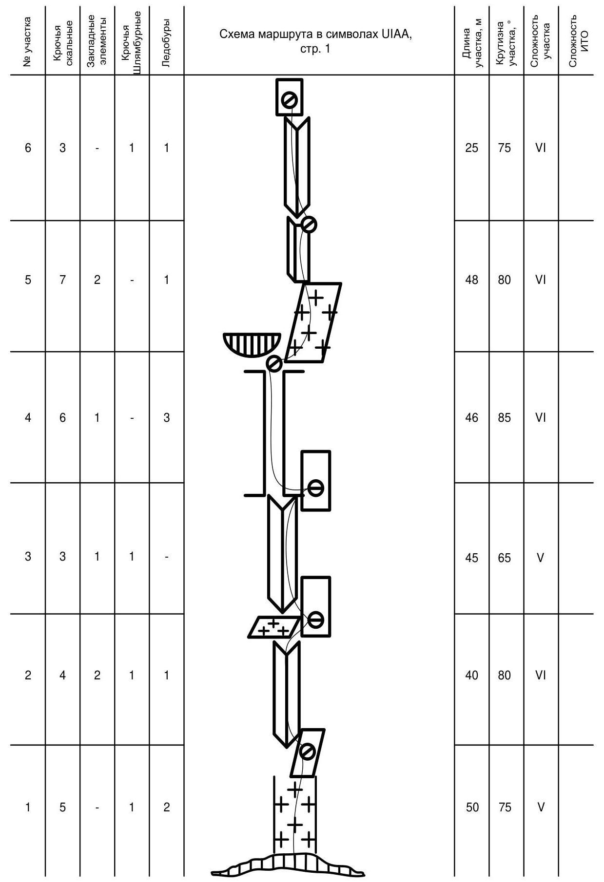
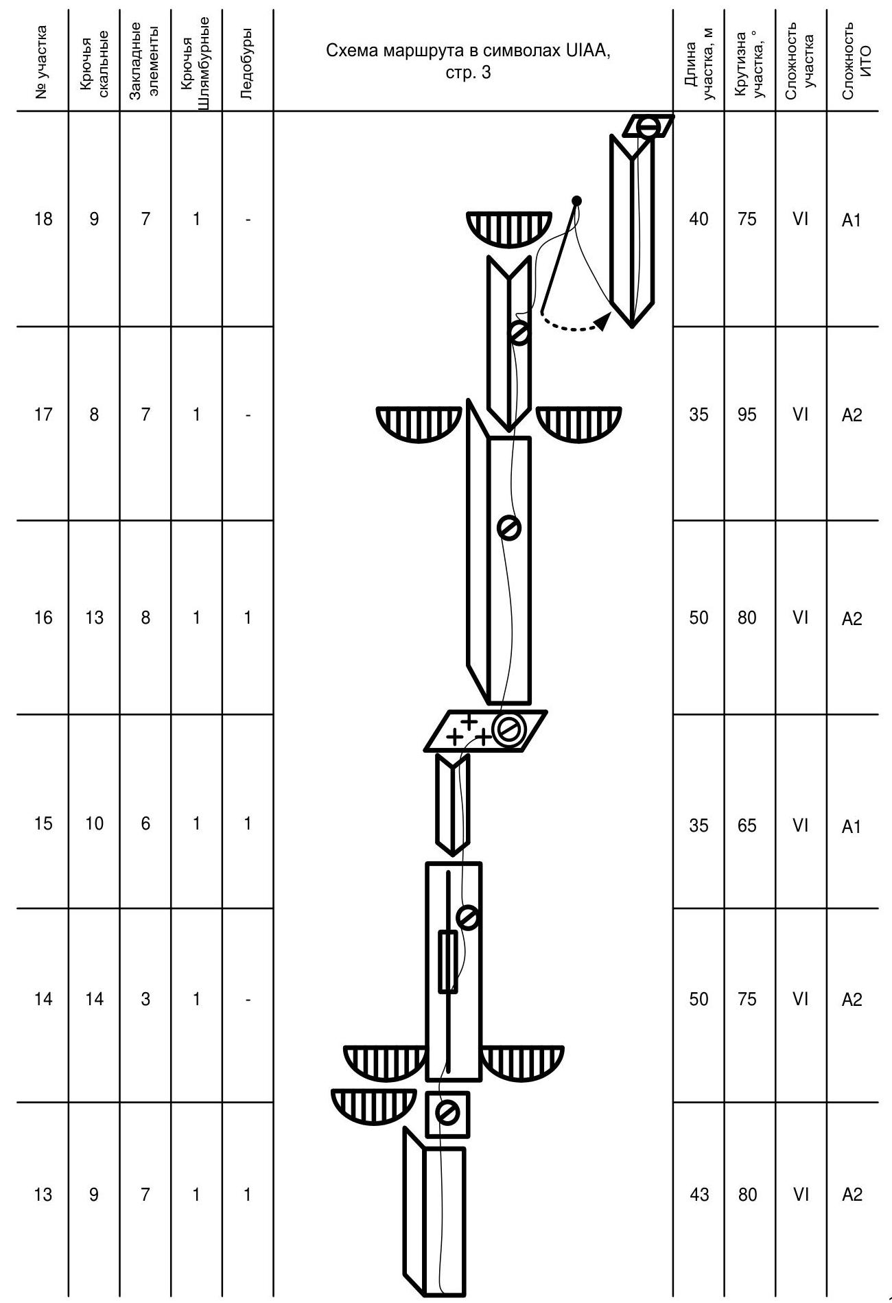
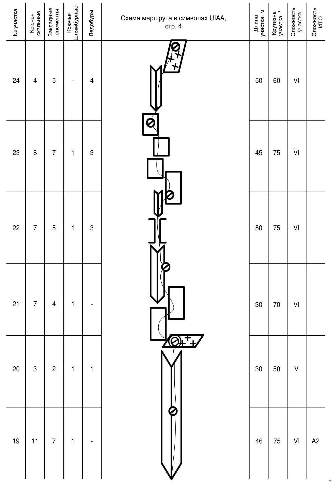
| Section # | Rock hooks | Nuts | Pitons | Ice screws | Section length, m | Section steepness, ° | Section difficulty | ITO difficulty |
|---|---|---|---|---|---|---|---|---|
| R1 | 5 | - | 1 | 2 | 50 | 75 | V | |
| R2 | 4 | 2 | 1 | 1 | 40 | 80 | VI | |
| R3 | 3 | 1 | 1 | - | 45 | 65 | V | |
| R4 | 6 | 1 | - | 3 | 46 | 85 | VI | |
| R5 | 7 | 2 | - | 1 | 48 | 80 | VI | |
| R6 | 3 | - | 1 | 1 | 25 | 75 | VI | |
| R7 | 5 | 1 | 1 | 2 | 45 | 50 | IV | |
| R8 | 12 | 3 | - | - | 46 | 80 | VI | A2 |
| R9 | 10 | 2 | 1 | 1 | 37 | 75 | VI | A1 |
| R10 | 16 | 4 | 1 | - | 50 | 75 | VI | A2 |
| R11 | 11 | 6 | 1 | 1 | 35 | 80 | VI | A2 |
| R12 | 8 | 7 | 1 | - | 30 | 75 | VI | A1 |
| R13 | 9 | 7 | 1 | 1 | 43 | 80 | VI | A2 |
| R14 | 14 | 3 | 1 | - | 50 | 75 | VI | A2 |
| R15 | 10 | 6 | 1 | 1 | 35 | 65 | VI | A1 |
| R16 | 13 | 8 | 1 | 1 | 50 | 80 | VI | A2 |
| R17 | 8 | 7 | 1 | - | 35 | 95 | VI | A2 |
| R18 | 9 | 7 | 1 | - | 40 | 75 | VI | A1 |
| R19 | 11 | 7 | 1 | - | 46 | 75 | VI | A1 |
| R20 | 3 | 2 | 1 | 1 | 30 | 50 | V | |
| R21 | 7 | 4 | 1 | - | 30 | 70 | VI | |
| R22 | 7 | 5 | 1 | 3 | 50 | 75 | VI | |
| R23 | 8 | 7 | 1 | 3 | 45 | 75 | VI | |
| R24 | 4 | 5 | - | 4 | 50 | 60 | VI | |
| R25 | - | - | - | 4 | 50 | 55 | V | |
| R26 | - | - | - | 4 | 35 | 50 | V | |
| R27 | - | - | - | - | 250 | 30 | III | |
| R28 | - | - | - | - | 15 | 60 | V |
Verbal description of sections
R1 — From the rancluclft straight up a vertical ice-filled crack. Station on the right on a piton on a small inclined wall. 50 m, 75°, V
R2 — Continue moving up the internal corner filled with ice. The corner leads to a vertical slab, at the base of which a piton is placed. 40 m, 80°, VI
R3 — Move up the iced internal corners to the base of a huge rock wall, where a piton is placed. 45 m, 65°, V
R4 — Move up the chimney with ice rivulets under a large cornice. On the slab under the cornice, a station is set on ice screws and anchor hooks. 46 m, 85°, VI
R5 — From under the cornice, move up to the right via a frozen waterfall. Then, up the iced internal corner vertically. 48 m, 80°, VI
R6 — Up the iced internal corner vertically to exit onto a large snow-covered conical ledge. At the base of the vertical wall on the lower part of the ledge, a station is set on a piton. 25 m, 75°, VI
R7 — Along the inclined ledge, first up to the right to the camping spot, then 25 m up to the left under the wall with a system of cracks. 45 m, 50°, IV
R8 — Up the system of cracks vertically under the base of the convex part of the wall. Cross the convexity up to the right, exiting onto a small inclined wall. Station on the wall. 46 m, 80°, VI, A2
R9 — To the right of the inclined wall, a 25 m vertical wall begins with a system of cracks. Move straight up until reaching a snow-covered inclined ledge. The ledge leads to an iced couloir. Traverse it to the right along the wall with a huge crack, at the base of which a piton is placed. Station on it. 37 m, 75°, VI, A1
R10 — Up the vertical slabs with a system of cracks straight up, aiming for a large internal corner filled with ice, and then up the internal corner. The internal corner opens up, and to the right on the slabs, a piton is placed, serving as a station. 50 m, 75°, VI, A2
R11 — From the station, a large iced chimney begins, leading to an inclined snow and ice ledge on the left and a large internal corner on the right. At the base of the internal corner, a piton is placed. Camping spot on the ledge. 35 m, 80°, VI, A2
R12 — Up the large internal corner filled with ice and snow drifts, straight up. Semi-suspended station. 30 m, 75°, VI, A1
R13 — Continue moving up the internal corner. The corner leads to huge cornices. To the right, behind the internal corner, a small wall is located, on which a piton is placed. 43 m, 80°, VI, A2
R14 — Up the wall under a small cornice. Then, enter a crack of variable width and move up and slightly to the right. 50 m, 75°, VI, A2
R15 — Continue moving up the crack, transitioning into an internal corner. Exit onto an inclined snow-covered ledge. Camping spot on the ledge. 35 m, 65°, VI, A1
R16 — Traverse the ledge 5 m to the right directly to a huge internal corner filled with ice. Up the internal corner vertically. 50 m, 80°, VI, A2
R17 — The internal corner leads to overhanging cornices. After overcoming the cornice, enter another internal corner leading vertically up. 35 m, 95°, VI, A2
R18 — From the station, continue moving up under the overhang. Then, a pendulum move to the right into an internal corner. Up the internal corner vertically. At the exit from the internal corner, a convenient ledge is available for a station. 40 m, 75°, VI, A1
R19 — Continue moving up the internal corner, partially iced. 46 m, 75°, VI, A1
R20 — Move 10 m up the internal corner and exit to the right onto an inclined iced ledge. The camping spot is inconvenient but tolerable. 30 m, 50°, V
R21 — From the left of the inclined ledge, exit to an iced internal corner via a system of inclined slabs. 30 m, 70°, VI
R22 — Up the internal corner, periodically transitioning into a chimney and back, move vertically up. Station on a small ledge to the right. 50 m, 75°, VI
R23 — From the station, move up to the left via a frozen stream. Station — a piton on a small wall. 45 m, 75°, VI
R24 — From the station, move up to the left via a large crack filled with ice. Then, enter inclined snow and ice walls and from there onto an ice slope. Station on ice screws. 50 m, 60°, VI
R25 — The rope is on the ice. Approach 3 huge snow "mushrooms" hanging from the ridge. 50 m, 55°, V
R26 — Another 20 m on the ice, pass under the "mushrooms" and exit onto the Eastern ridge. 35 m, 50°, V
R27 — Ascend the Eastern ridge towards the summit. 250 m, 30°, III
R28 — The summit is rocky. To reach it, overcome a couple of walls. On the last one, a tin can with a tube containing a summit note hangs. 15 m, 60°, V
Technical photo of the route.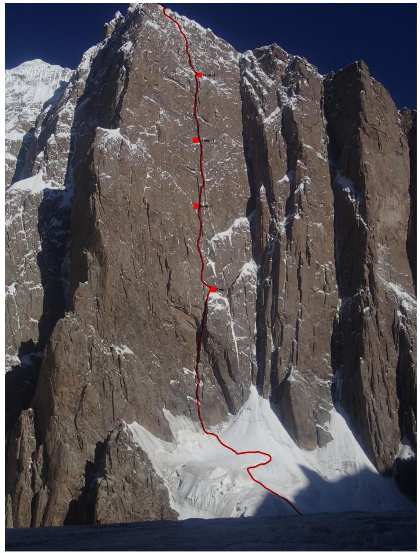
Photo illustrations
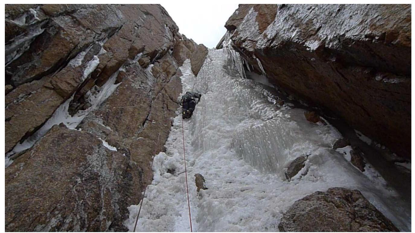
Photo 1. Section R3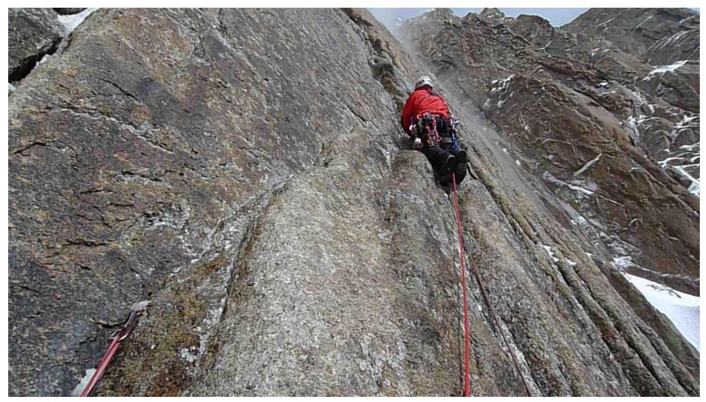
Photo 2. Section R6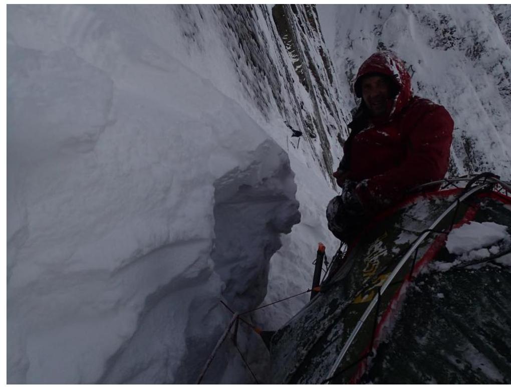
Photo 3. Camp 1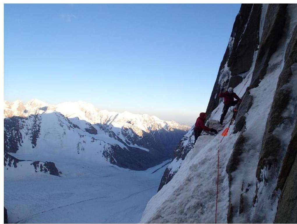
Photo 4. Setting up Camp 2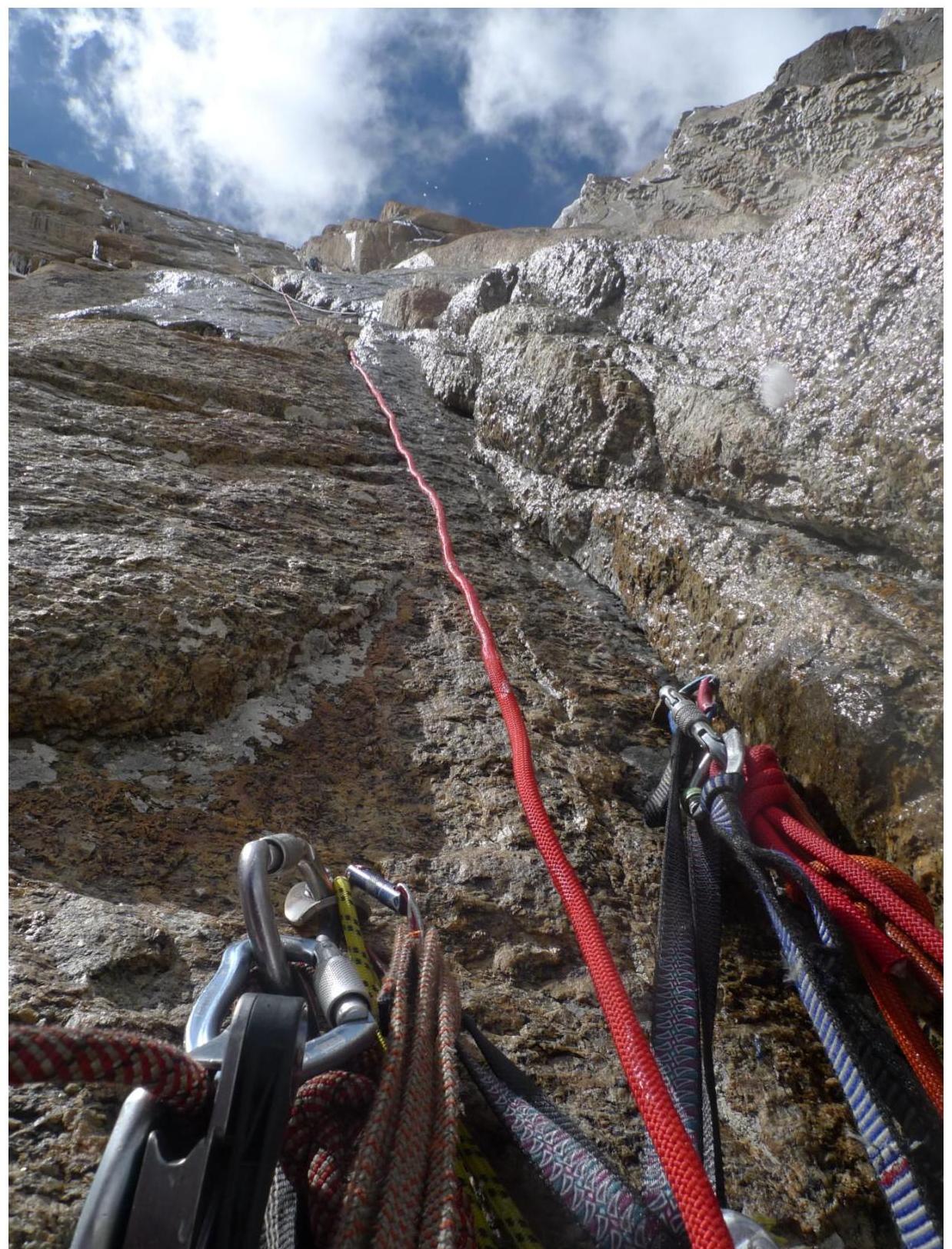
Photo 5. Section R10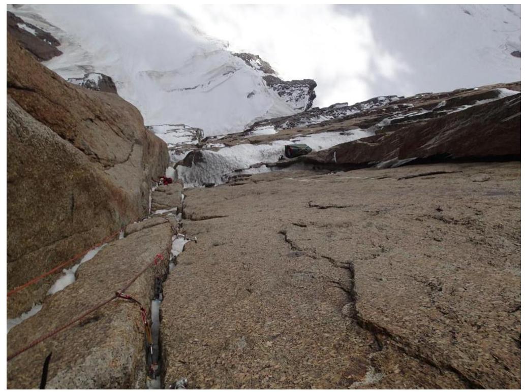
Photo 6. Section R11. View down.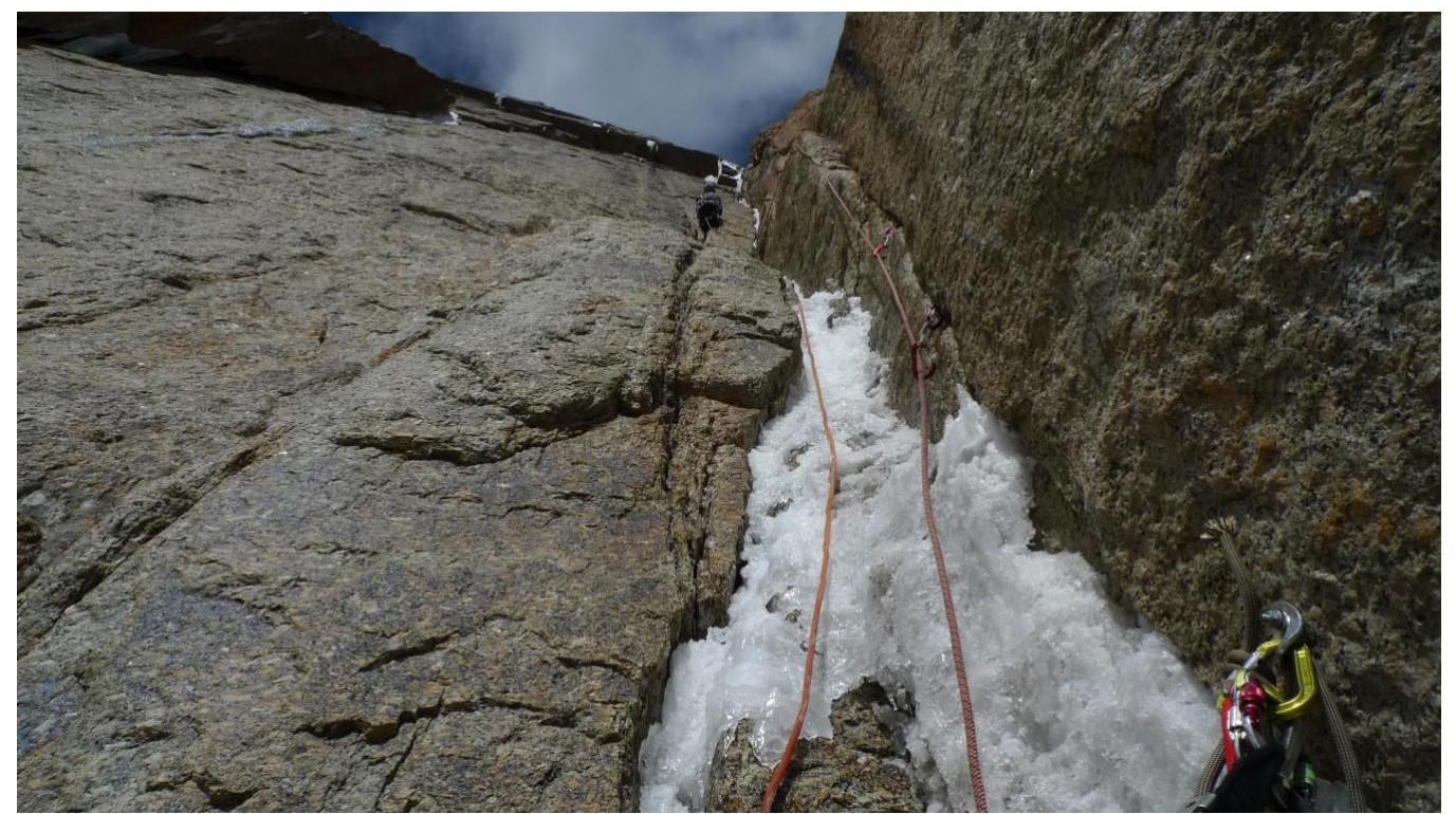
Photo 7. Section R13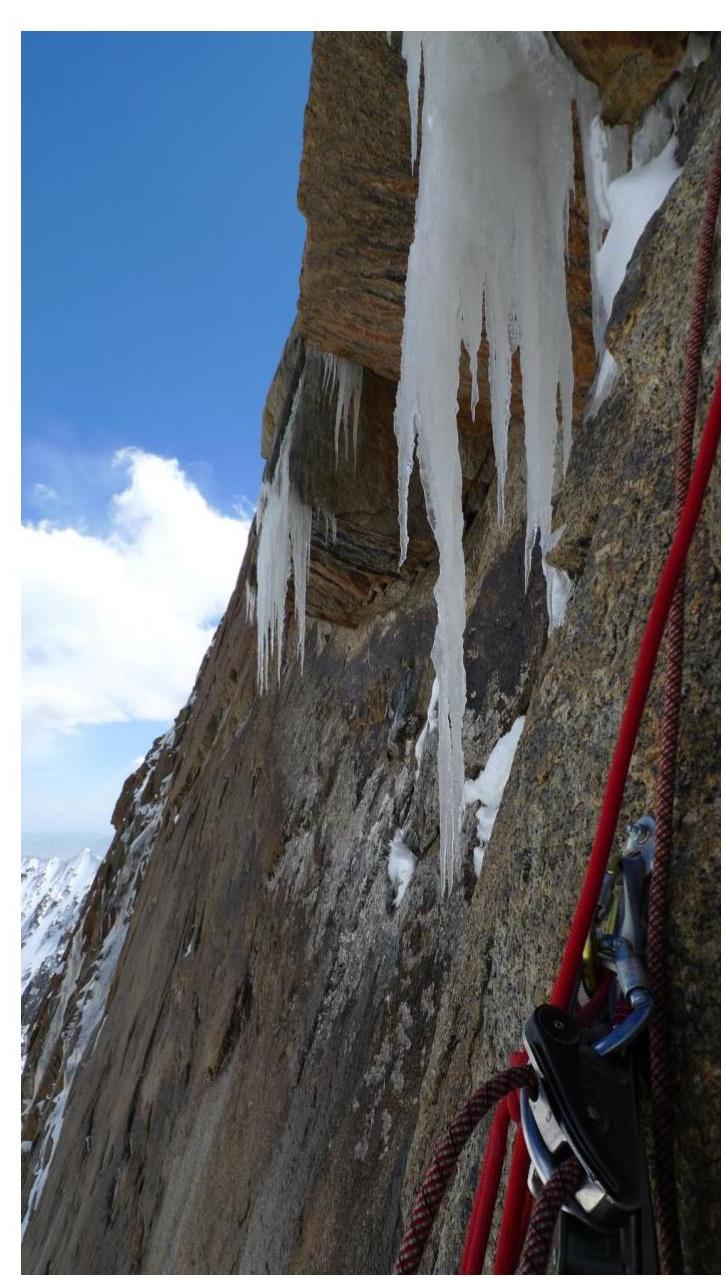
Photo 8. Section R15
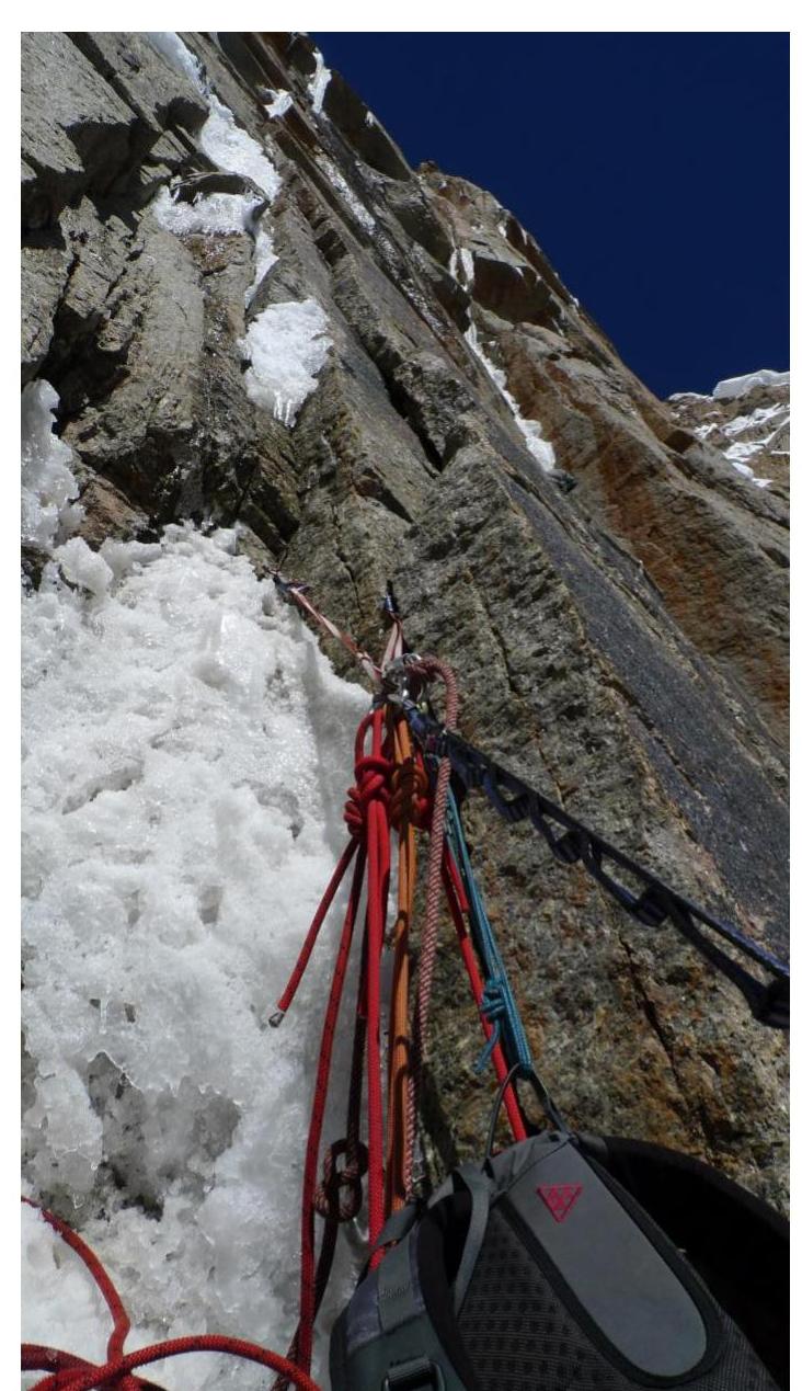
Photo 9. Section R16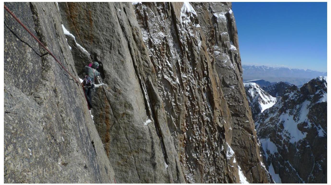
Photo 10. Section R17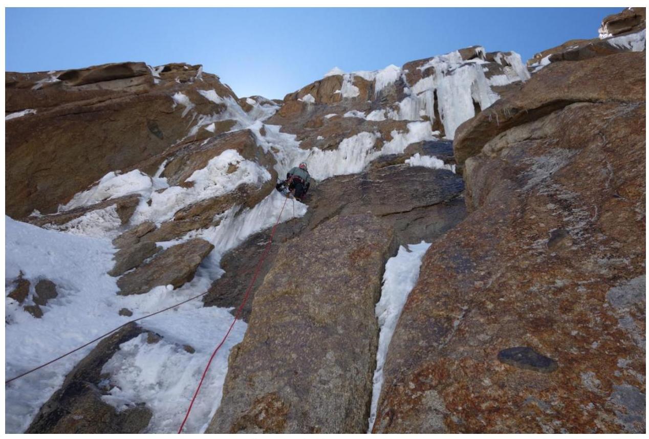
Photo 11. Section R21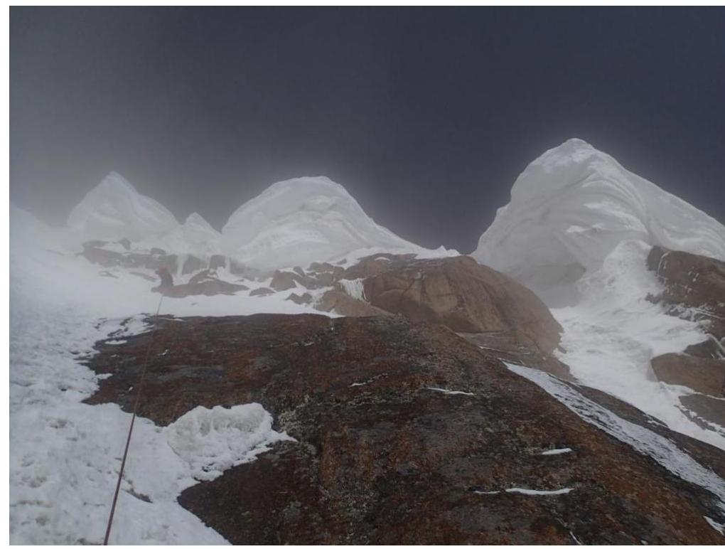
Photo 12. Section R25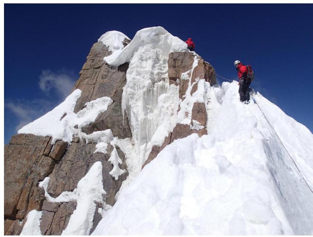
Photo 13. Summit approach
Comments
Sign in to leave a comment