Passport
- Technical category
- Tian-Shan, western Kokshaal-Tau, Aitola gorge
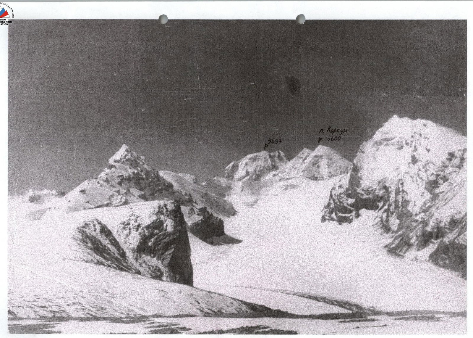
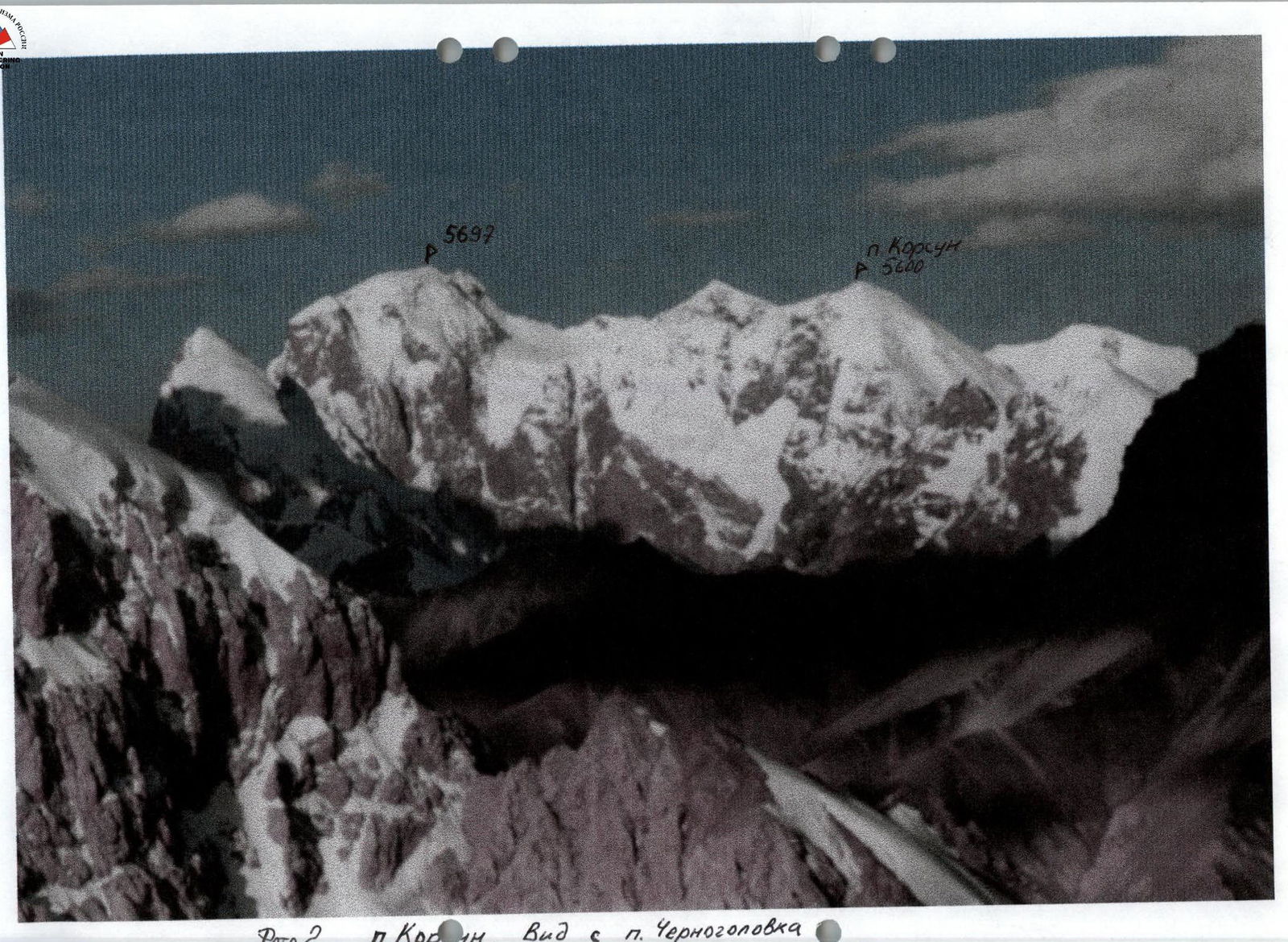
- Peak Korsun (5600 m) from the northwest
- Proposed 5A category, first ascent
- Elevation gain 900 m.
Length 1800 m. Length of 5th category sections — 500 m. Average steepness:
- main part of the route — 45°
- entire route — 40°
- Ice screws used — 60
- Team's travel hours — 16, days — 2
- Overnight stay — on a snow plateau
- Captain: Starostin B.N., 1st sports category Team members: Smirnov A.V., 1st sports category; Shamonov I.S., CMS
- Coach: Lebedev M.V., CMS
- Approach to the route — August 15, 2000
Summit — August 16, 2000. Return — August 16, 2000
Brief Overview of the Ascent Area
Peak Korsun is located in the Western Kokshaal-Tau region. Climbing exploration of this area began in 1932 with Letavet's expedition.
In subsequent years, the following expeditions took place in the area:
- 1969 — an expedition by Moscow region climbers, which traversed peaks Kibalchich, Korolev, and Tsander (4th place in the 1969 USSR Championship);
- early 1970s — an expedition by Kazakh climbers from the "Enbek" society;
- 1989 — Kazakh expeditions led by Popenko, Valiev, Ilyinsky, and Sidelnikov in the most accessible western part of the ridge, near peak Kyzyl-Asker;
- 1993 and 1996 — expeditions by Moscow region climbers to the Chon-Turasu gorge;
- 1998 — an expedition by Moscow region climbers to the Jurek gorge.
After a long break, Moscow region climbers resumed active exploration of this area and organized three expeditions in a short period.
In 1993, five first ascents were made to various peaks in the gorge, including peak Alpinist (6B category) (1st place in the 1993 CIS Championship).
In 1996:
- First ascent to peak Trapezium (5B category) (4th place in the 1996 Moscow Championship)
- Two new routes were climbed on peak Alpinist
- The ascent to peak Joldash — the main goal of the expedition — was not achieved.
In 1998, peak Joldash was conquered from the north, a new route was laid to the highest point in the area — peak Dankov, and five first ascents were made to various peaks in the Jurek gorge.
The Western Kokshaal-Tau region is characterized by harsh climatic conditions and frequent bad weather. The rocks are of two types:
- monolithic, smoothed black "ram's foreheads" with few thin cracks;
- or monolithic outcrops with few holds but with wide cracks.
On ridge sections, the rocks are heavily destroyed with many "live" stones and minimal opportunities for setting up belay points.
There are three options for reaching the Western Kokshaal-Tau region:
- by helicopter from Bishkek or Karakol;
- by vehicle via the route: Bishkek — Issyk-Kul — Barskoon settlement, Barskoon and Suek passes into the Naryn river valley to the Karasai settlement, where a border outpost is located, then across the Barkoldoy ridge into the Uzenge-Gush river gorge and further up to the confluence with the Jurek river. The entire journey from Bishkek to the base camp takes two days (about 500 km);
- by vehicle from Bishkek through Naryn to the upper reaches of the Aksay river.
We used the 2nd option.
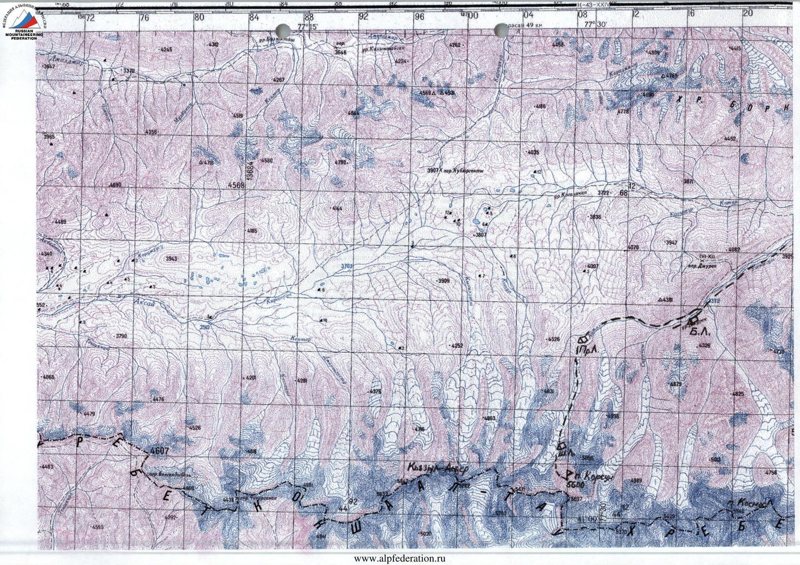
The base camp was set up in the Sarychat gorge, half a kilometer from its confluence with the Jurek river. Unfortunately, due to the impassability of the gorge for vehicles, it was not possible to locate the base camp further upstream. As preliminary reconnaissance showed, there were
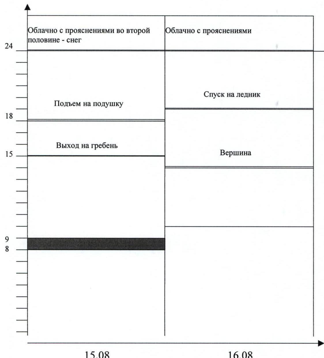
Ascent Schedule
two paths to the intended ascent objective. The first — along the right bank of the Sarychat river and then along the glacier to the northeastern slopes of the peak. The second — along the left bank to the confluence of the Aitola river and then along the Aitola river and glacier to the northwestern slopes. We chose the second path, as the glacier from which the Sarychat river flowed appeared to be quite laborious to traverse.
Due to the lengthy approach, it was necessary to establish:
- the first intermediate camp — within a hour's walk from the glacier tongue;
- and the second camp — directly below the route.
Approach time:
- from the base camp to the first intermediate camp — 4–5 hours;
- from the first intermediate camp to the second — approximately the same.
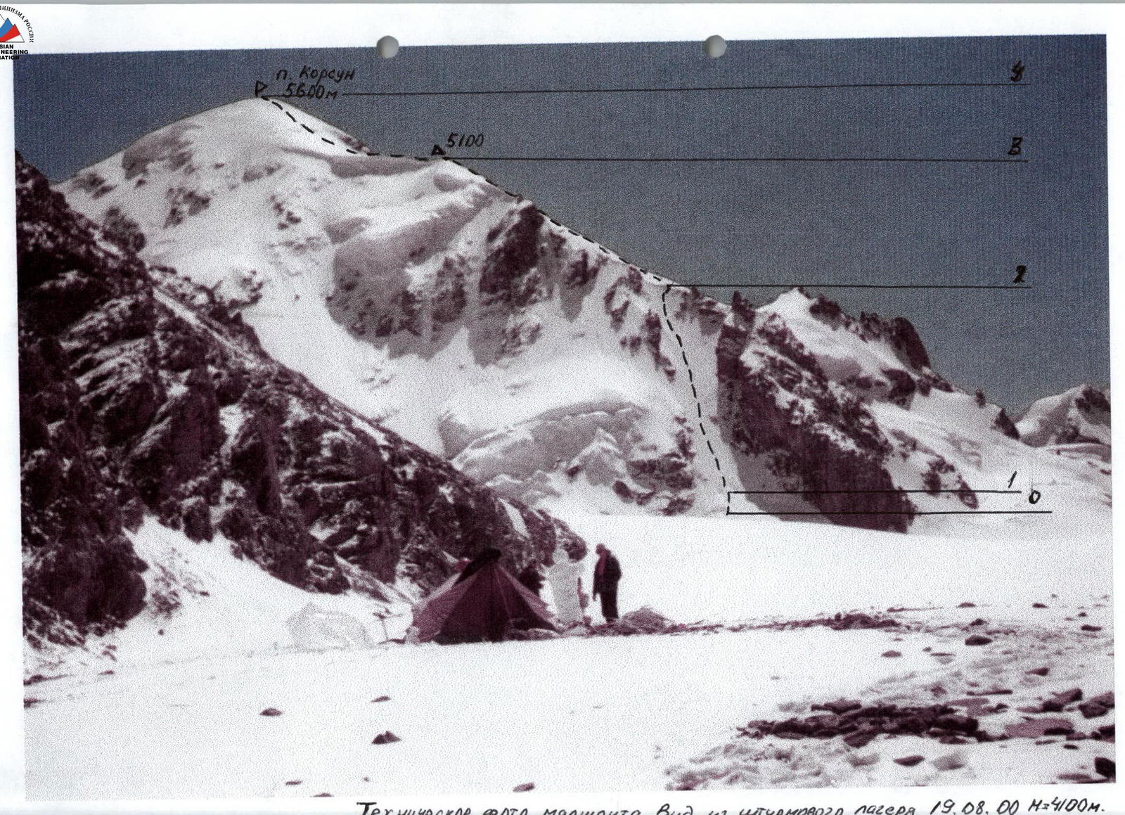
Technical photo of the route. View from the assault camp on August 19, 2000 (H=4100 m).
Tactical Actions of the Team
August 15
The team left the overnight stay on the moraine of the glacier under the route at 8:00. They approached the start of the route via the glacier. The planned route passed through the center of a wide ice-snow couloir, narrowing at the top and leading to the southwestern ridge of the peak. Then — along a snow slope to a wide "cushion". At 9:00, they began working on the route. Starostin B. led.
At the beginning of the couloir, they overcame a not very wide bergschrund filled with snow. After two ropes, they reached ice covered with a thin layer of firn. Further movement was carried out using the usual technique for such slopes:
- The first climber went with two ice axes, placing intermediate ice screws — two per rope.
- The second quickly followed along the fixed rope and provided belay to the first.
- The third moved along the fixed rope, removing ice screws.
The average steepness of the couloir was approximately 65°. During the ascent, and later during the descent through the couloir, there were no rockfalls or ice falls. This confirmed the correctness of the chosen route.
The exit to the ridge was via small rocks. The first climber reached the ridge around 14:00. The further path went along a snow slope with small ice outcrops in deteriorating weather conditions. In the middle of the slope, they had to wait for about 30 minutes, as visibility dropped to three meters, and there was a risk of stumbling into rockfall zones. After some clearing, the team continued moving and reached the "cushion" by 18:00. On this section of the route, they moved simultaneously with belay through ice axes. The "cushion" offered an excellent spot for an overnight stay.
August 16
At 10:00, the team began moving along the route. After passing the "cushion", they reached a snow slope with a steepness of about 45°. The snow crust was hard, frozen, and practically did not give way underfoot. Movement was in crampons, simultaneously.
The summit was reached at 13:45. Unfortunately, the deteriorating weather conditions did not allow for a detailed examination of the surrounding panorama. On the summit:
- they built a cairn;
- left a note.
At 14:15, they began their descent. The descent followed the ascent route.
- Down to the couloir, they moved simultaneously, except for a section with ice outcrops after the "cushion";
- in the couloir, they descended on ropes;
- the last one descended on a self-retracting ice screw.
They reached the glacier by 19:00. Throughout the route, the team maintained communication with the rescue team via radio.
Backup support was provided by the rescue team consisting of:
- Lebedev — CMS
- Lavrushev — CMS
- Krysyuk — honored master of sports, doctor
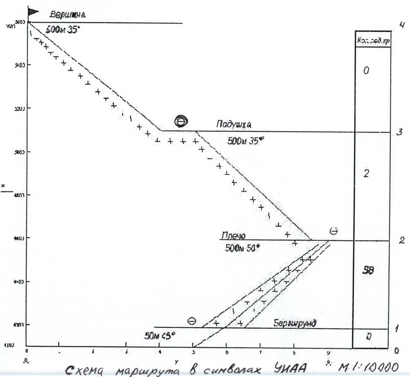
Route Diagram in UIAA Symbols. Scale 1:10000
- Summit (500 m, 35°)
- Cushion (500 m, 35°)
- Shoulder (500 m, 50°)
- Bergschrund (50 m, 45°)
- Categories of difficulty: 0, 1, 2, 3, 4, 5B.