Passport
- Class — high-altitude technical
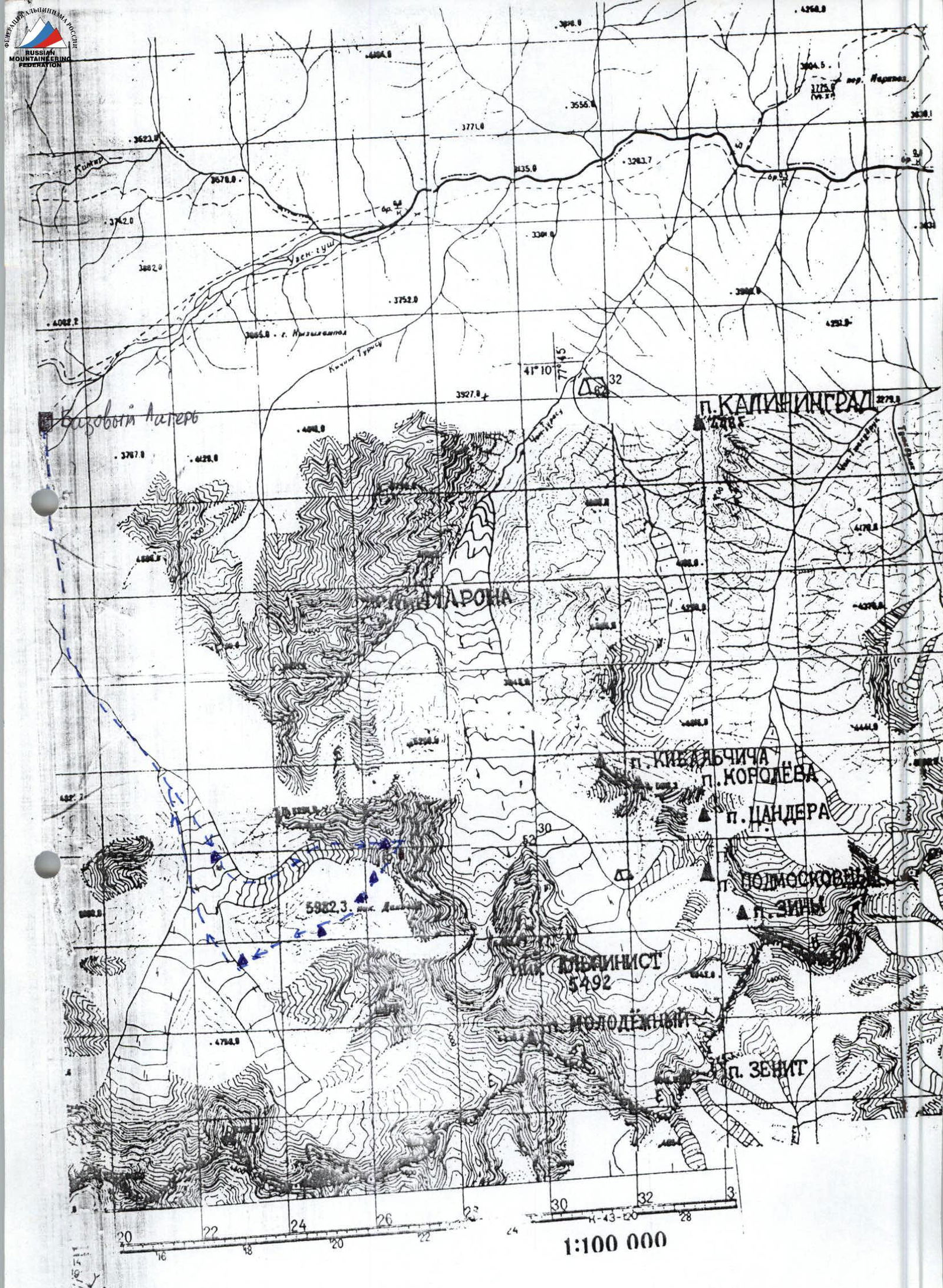
- Tian Shan, western Kokshaal-Too
- Peak Dankova via NNE ridge (5982 m)
- Category 5B difficulty, first ascent
- Elevation gain — 1650 m
Distance — 2200 m. Category 5B difficulty sections — 580 m. Average steepness of the main part of the route — 62°
-
Pitons used:
rock 14/2, nuts 8, ice screws 74
-
Climbing hours — 22 and days — 3
-
Overnight stops:
1st — on a hacked platform — sitting; 2nd — on a snowy ridge — lying
-
Captain: Boyko V.V., Master of Sports
Team members: Lebedev M.V., Candidate for Master of Sports Lebedeva E.V., Candidate for Master of Sports Smirnov A.V., Candidate for Master of Sports Shimokhin I.A., 1st sports category
-
Coach: Monaenkov E.I.
-
Departure from base camp — August 1, 1998
Start of the route — August 3, 1998 Summit — August 5, 1998 Return to base camp — August 7, 1998
Coach of the training camp Master of Sports E.I. Monaenkov
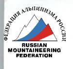
- via NNE ridge, category 5B (Boyko, 1998)
- via NW wall, category 5B (Popenko, 1972)
About the Route
We first saw the route to Peak Dankova in 1996 during a training camp for the Moscow region near Peak Alpinist. We noted the logic of this route and wondered why it had not been climbed before.
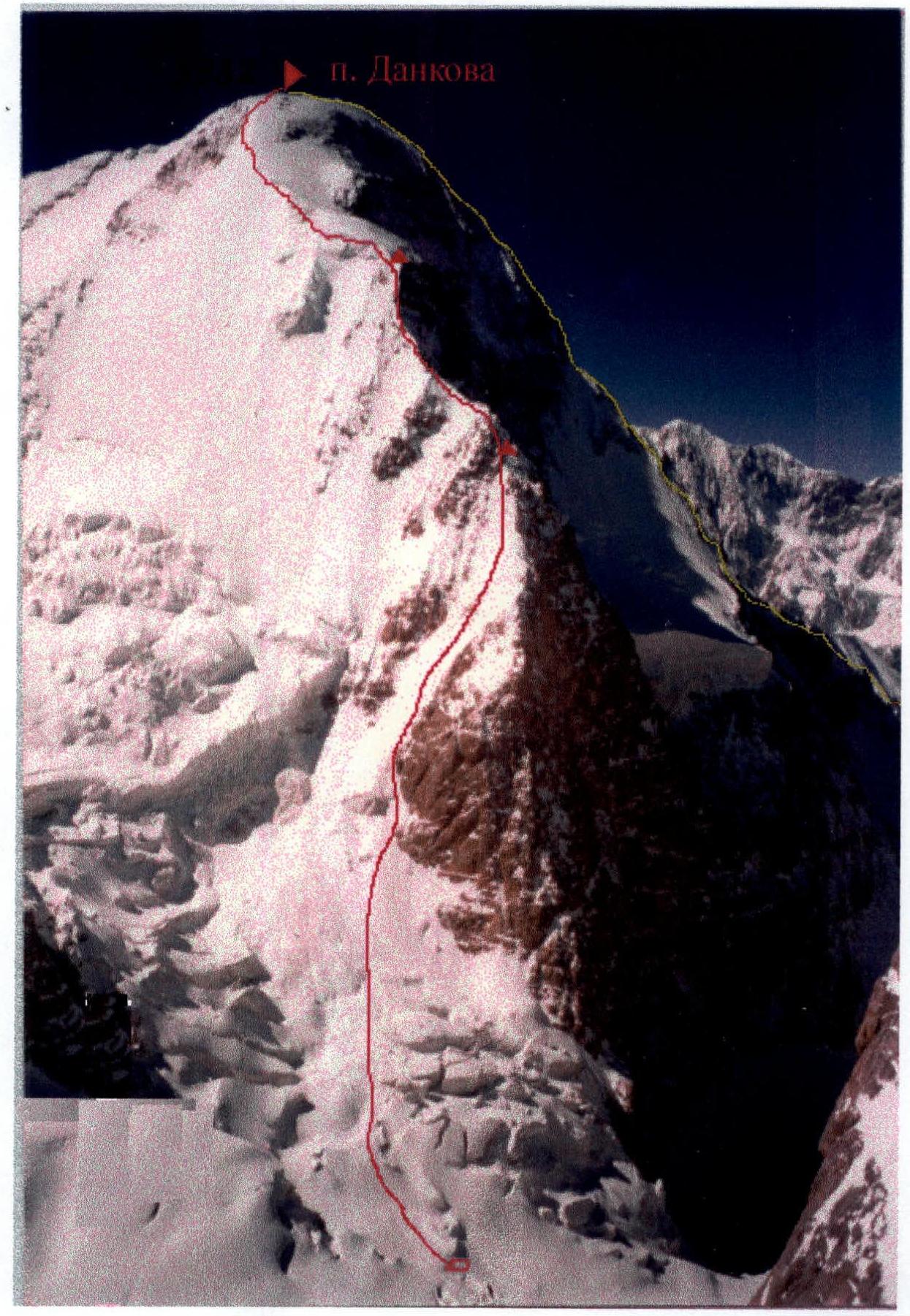
During reconnaissance trips on the 1998 training camp, we circled Peak Dankova from almost all sides, but couldn't directly approach the route due to the hazardous path through a closed serac zone and bad weather. This closed serac zone, with numerous crevasses, which under certain conditions can be impassable, was, in our opinion, the reason this route remained unclimbed.
August 1, 1998 — We left the base camp after lunch. We reached our cache in about 3 hours and set up camp at the beginning of the serac zone.
August 2, 1998 — We started early. We traversed three steps of the serac zone in about 5 hours and stopped in a convenient and safe depression below a rocky bastion. The rope team (Boyko, Lebedev) ascended to the left of the bastion onto the col between Peak Dankova and Peak Joldash. We looked at a logical path to Peak Joldash via an ice slope. (Later, a team led by Fedor Akhmatov completed this route, making a first ascent of this beautiful mountain).
We didn't find a feasible route to Peak Dankova from the col, but took several photos and identified a possible approach path to the right of the bastion. The remaining three team members set up camp and searched for a passage through the serac zone to the right of the bastion. In the evening, based on our reconnaissance, we decided on our course of action.
August 3, 1998 — We started at dawn. We were lucky, and a snow bridge over a large crevasse in the serac zone allowed us to approach the route. This section needs to be traversed very early and with caution: many signs of icefall from upper cornices. Then, bypassing a triangular, icy, and rugged wall on the left (which, in our opinion, could be an object for the Russian Championship), we reached the ridge. We climbed in crampons on the front points all the time. Rappel lines. Rocks and ice were falling from above, and we had to be very cautious. The last few pitches — deep snow on ice that was sliding and didn't hold. We had to dig a trench to reach the ice. On the rock-ice ridge, we tried to hack out a platform for a tent (in two places) but managed only to organize a sitting bivouac.
August 4, 1998 — We moved up along a not very pronounced icy ridge, staying on the left part. All crevasses were filled with ice, creating problems for belay organization. We had to climb icy rocks in crampons, which was very unpleasant.
August 5, 1998 — Climbing through deep snow in the morning. Sometimes we encountered hidden crevasses. When we reached the summit ridge, the weather deteriorated significantly: visibility 10–20 m, snowstorm. The ridge was quite sharp with large snow cornices. We used ice screws for belays the entire time. The summit was not clearly defined, and there was nowhere to leave a note — all snow, ice, and cornices.
Descent towards Peak Kosmos:
- We had to wait for over an hour for a break in the weather to see where to move.
- Then, during the descent, we periodically sat down and waited.
- We completed 5–6 rappel pitches (sporting style), after which we reached snowfields.
- Then we descended on foot down and to the left towards rocky outcrops.
- Overnight stop on a small talus platform.
August 6, 1998 — Again, fog. Visibility 10–20 m. Ideally, we should have waited for better weather, but Igor had a birthday, and we were expecting cake, cognac, etc., down below. As a result, we missed a good descent route and ended up on rocky drop-offs resembling "ram's foreheads." Luckily, we had about 15 pitons, but we descended onto the talus in the dark. Instead of cake, we had to settle for oatmeal porridge with water and no sugar.
August 7, 1998 — Returned to base camp by breakfast.
View of the approach to the route from Grigoriev Glacier.