Passport
- Technical class.
- Central Tien Shan, western Kok-Shaal-Tau.
- Peak 4850 "Verny" via the NW buttress of the wall.
- Proposed: 5B category of difficulty, first ascent.
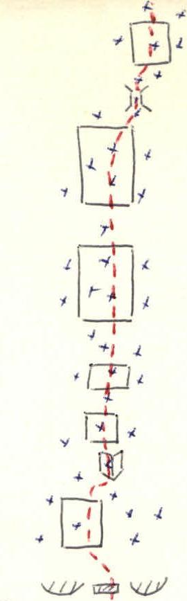
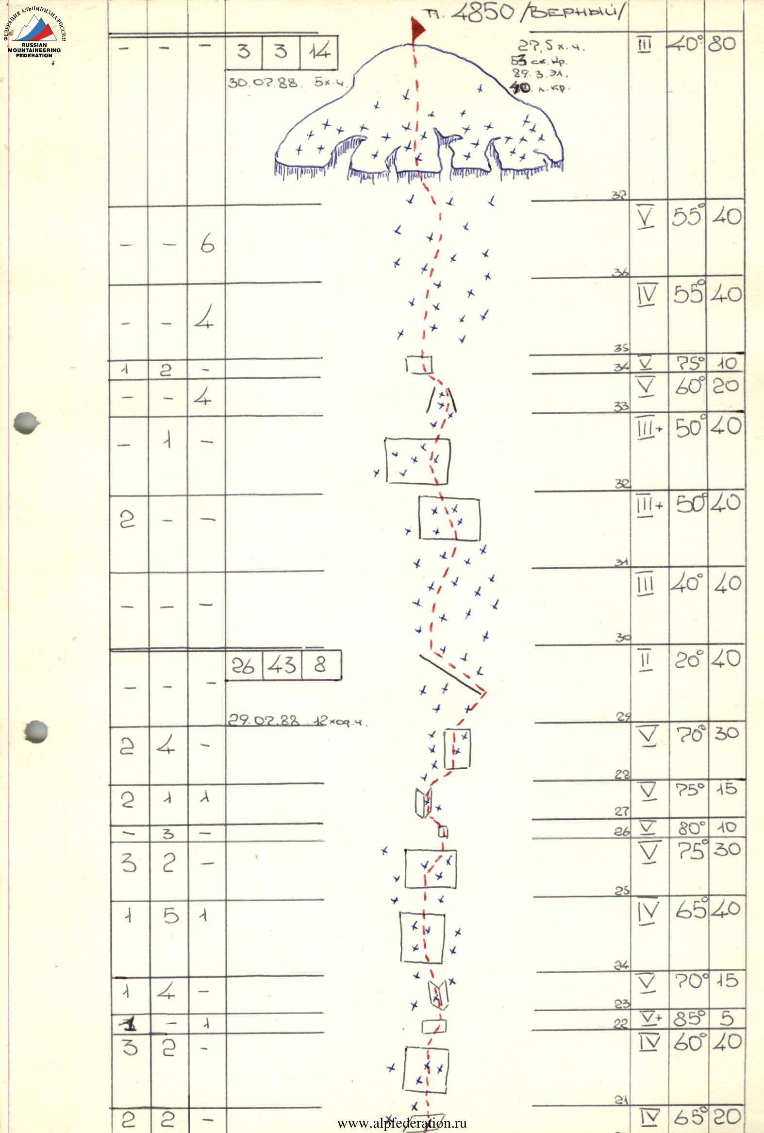
- Height difference: 916 m, length — 1028 m, length of sections with 5–6 category of difficulty — 478 m, of which 6 category of difficulty — 112 m, average steepness: main part of the route 71° (3934–4594), of which 6 category of difficulty 83° (4006–4266).
- Pitons driven:
| Category | Driven | Left |
|---|---|---|
| Rock | 53 | 13 |
| Bolts | 0 | 0 |
| Chocks | 89 | 24 |
| Ice screws | 40 | 0 |
- Time taken: 27.5 hours, 3 days.
- Overnight stops: 1st on the glacier under the route, 2nd on the saddle.
- Leader: Sp. ak. TUGALEV Vladimir Gennadievich — CMS
Team members:
- Ryad. ZAPYATY Viktor Anatolievich — CMS
- Ryad. KARPOV Evgeny Anatolievich — 1st sports category
- Ryad. IVANOV Alexey Evgenievich — 1st sports category
- Sr. coach: Honored Coach of the USSR ILYINSKY Yervand Tikhonovich
Coaches: Honored Coach of the Kazakh SSR AYGISTOV Gleb Andreevich Honored Coach of the Kazakh SSR SEDELNIKOV Viktor Nikolayevich
-
Approach to the route: July 28, 1988 Summit: July 30, 1988 Return: July 30, 1988
-
Organization: 12 Sports Club of the Army SAVOU
GENERAL PHOTO of the summit. July 27, 1988. 10:25. Lens Mir 24, F-35 mm, distance 0.8 km. Point of survey №1 Height 3700.
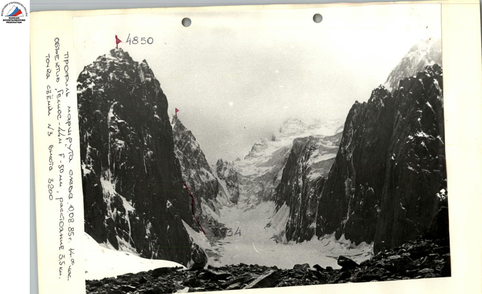
Profile of the route from the left on August 10, 1985. 14:00. Lens "Helios-44M", F-50 mm, distance 3.5 km. Survey point №3, height 3200.
Brief overview of the ascent area
Peak 4850 "Verny" is located at the western end of the Kok-Shaal-Tau ridge. The ascent area is in a border zone and is not frequently visited by mountaineers. In 1980, an attempt was made to ascend Peak Kyzyl-Asker 5842 m by a team from SAVO "led by Yu. POPENKO". Due to a fall and injury to one of the participants, the ascent was aborted. One of the groups from this expedition made a first ascent of Peak Panfilovskaya Diviziya 5250 m, but the route was not classified. In 1985, a team from SAVO "led by K. VALIEV" completed a first ascent of Peak Kyzyl-Asker as part of the USSR Championship in the high-altitude technical class. The area can be reached:
- Through the city of Naryn on the Naryn–Atbashi highway,
- Turning off towards the village of Akmuz along the Ak-Sai river valley to the border outpost of the same name.
From here, the peaks of Kyzyl-Asker and 4850 "Verny" are visible in good weather. Along the rather flat, marshy terrain, you can drive almost to the tongue of the Kyzyl-Asker glacier. The approach to the route takes about four hours. The object of the ascent is very interesting. The north-western wall of the summit is about 2 km wide. Several options for ascent of the highest category of difficulty can be chosen on it. At the same time, the left part of the wall is very prone to rockfall. An ascent via the northern ridge is also interesting, with a category of difficulty of 4–5, approximately. One of the features of the object is the weather conditions in the area — typical Tien Shan weather:
- The morning is usually clear,
- Clouds approach from the west by lunchtime,
- Snowfalls are frequent.
Snow that has melted on the rocks turns into rime ice by evening, greatly complicating the ascent in the morning hours.