Climbing Passport
I. Climbing type — ice and snow 2. Climbing area — Central Tien Shan, Ak-Tau ridge 3. Peak named after M. Auezov via the right part of the Eastern wall (5967 m) 4. Estimated category of difficulty — 5B (first ascent) 5. Height difference — 1447 m for the route, 1250 m for the wall section. Length — 1940 m for the route, 1440 m for the wall section. Length of sections with 5–6 category of difficulty — 1175 m. Of these, 25 m are category 6. Average steepness of the wall — 56° 6. Pitons hammered: * rock — 4/2 * bolt — (dash) * chocks — 13/5 * ice screws — 209/2 7. Team's total climbing hours — 31.5 (3 days) 8. Overnight stays: * 1st — lying in a bergschrund * 2nd — lying on a ridge 9. Team "ProfSport" of the Alpinism Department, All-Union Council of the VDFSO Trade Unions 10. Team leader — A.N. Rozhkov — Candidate Master of Sports Team members: * V.A. Suvorov — Candidate Master of Sports * A.P. Sushko — Master of Sports * V.I. Usas — Candidate Master of Sports 11. Team coach — A.N. Rozhkov 12. Departure to the route — August 15, 1989 Summit reached — August 17, 1989 Return — August 17, 1989
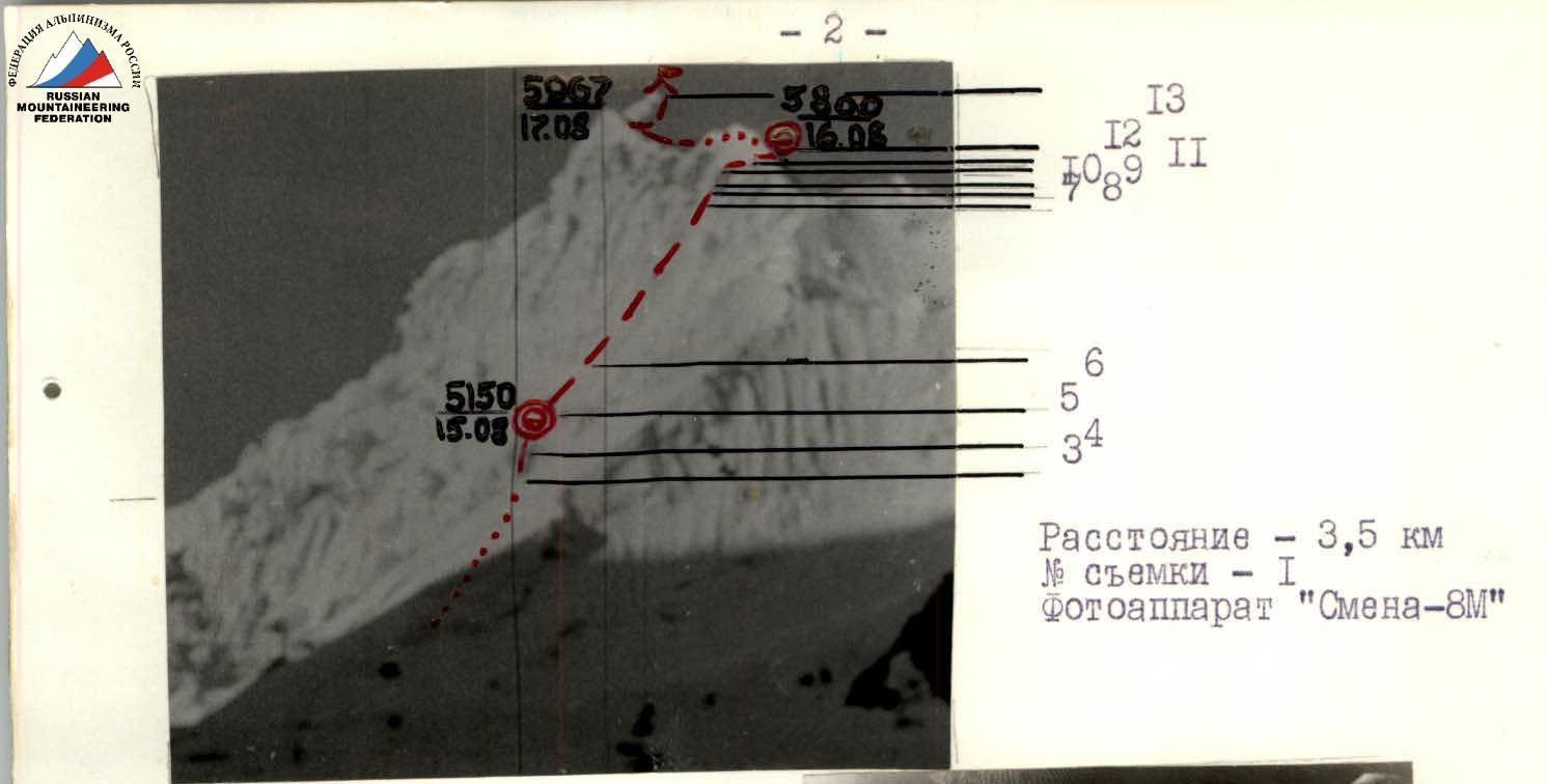
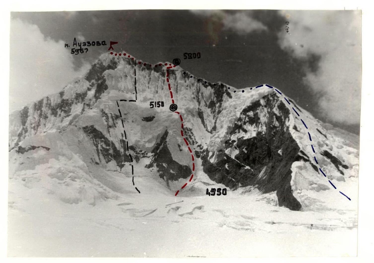 — route of the "ProfSport" team — route of the Kuibyshev team — route of the Leningrad team. Photo taken on August 11, 1989, 13:00. Distance — 2.5 km. Photo height — 4500 m. Photo number — 2. Camera "Smena-8M"
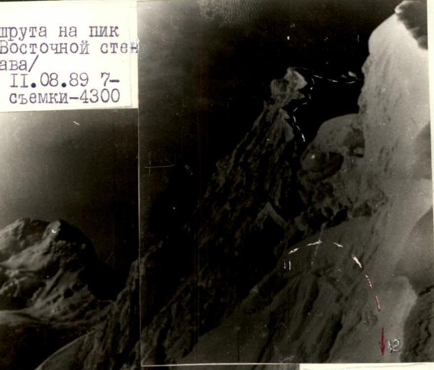
 Profile of the route to Peak Auezov via the Eastern wall (view from the right). Photo taken on August 11, 1989, 7:30. Photo height — 4300 m.
 View of the wall from the ridge (view from the right). Photo taken on August 17, 1989, 8:00. Photo height — 5800 m. Distance to point II — 80 m. Photo number — 4. Camera "Smena-8M"
 Profile of the route to Peak Auezov via the right part of the Eastern wall (view from the left). Photo taken on August 11, 1989, 12:00. Distance — 3.5 km. Camera "Smena-8M". Photo number — 3. Photo height — 4500 m. From section 12, movement along the ridge — 500 m.
 3 — photo point.
Brief Overview of the Climbing Area
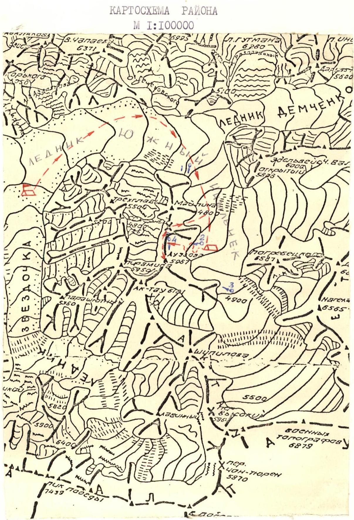
Peak named after M. Auezov is located in the Ak-Tau ridge. The Ak-Tau ridge is a lateral spur of the Kokshaal-Tau ridge. The Eastern wall of the peak:
- faces the upper reaches of the South Inylchek glacier;
- is opposite the Druzhba pass;
- is illuminated early in the morning. This explains the early illumination of the wall.
The height of Peak Auezov is 5967 m. The massif of the peak stretches for 3 km from north to south and ends at a pass, from which Peak Moilina (height 4800 m) continues. Until the 1989 USSR Climbing Championship in the ice and snow climbing category, the Eastern wall of Peak Auezov did not attract the attention of climbers. This is partly due to the inaccessibility of the area in terms of obtaining permits to enter the border zone, and the proximity of larger objects — Peak Pobeda and Khan Tengri. Additionally, the climb is purely ice, and the altitude limit for ice and snow climbing was raised to 6000 m for the first time. The climbing area was also limited to Tien Shan. The Eastern wall of Peak Auezov is a slope with a steepness of 50–60°. Ice is interspersed with steep snow and firn. The wall can be divided into two parts at the bergschrund boundary:
- the lower part consists of a cascade of ice drops;
- the upper part — ice gutters with firn growths, closed by a ribbon of summit rock bastions.
For a safe passage of the route, correct climbing tactics are necessary, taking into account temperature regimes. The most favorable time for climbing is mid and late August.
On clear nights, the temperature on the glacier drops to −15 °C. The weather in the area is very unstable, and snow typically falls in the second half of the day.
The approach from the base camps under Peak M. Gorky and on the Zvezdochka glacier to the Semenovsky glacier (turn towards the saddle between Peak V. Chapayev and Khan Tengri) takes 2 hours, and another 2 hours on the closed glacier to the turn towards the Druzhba pass. Here, there is a convenient bivouac for observing the wall. The transition under the wall takes about 2 hours due to numerous closed crevasses. From the settlement of Maydaadyr, a helicopter flight to the base camp takes about 30–40 minutes.
Special equipment is necessary for the climb — extended pitons and snow anchors (with stirrups).
The tactical plan included passing the route with one overnight stay; in case of bad weather, an additional overnight stay on the ridge was planned, which fully corresponds to the actual passage of the route by days. The route was completed in 3 climbing days from August 15 to 17, 1989, in 31.5 hours. Considering the complexity and length of the ice sections, as well as the virtually single safe place on the wall for a bivouac, the team planned for long loads of 12–15 hours per day. The team composition was even. Emphasis was placed on maximum autonomous rope team movement. Interaction was planned for complex sections. All rope teams worked on a single UIAA rope, which was shortened (doubled) according to the conditions of the route.
The main principle for choosing overnight stays and movement regime was safety. When drawing up the movement schedule, the early illumination of the wall was taken into account, so the group needed to be either on unlit sections or under rocks, or on them.
First day (August 15):
- Main task — to reach the bergschrund in the middle of the wall.
- Problematic sections — traverse under the ice drops to the exit to the bergschrund and exit along the bergschrund walls to the overnight stay.
Movement to the traverse was on schedule. Rope teams worked autonomously on a doubled rope.
On the traverse to the exit to the bergschrund, organizing protection was problematic due to destroyed rock slabs under the ice, which caused a 2-hour delay from the tactical plan. However, by 10:00, the group was in a shaded area with hard ice, and it was decided not to rush at the expense of organizing protection. Due to working on steep ice, the first climber went without a backpack; the backpack was pulled up on a harness.
The overnight stay was safe, in a grotto-bergschrund.
From 19:00 to 20:00, the next section after the bergschrund was processed. If Sushko worked first on the traverse, here Suvorov worked first. Extended pitons were used as necessary. All ice screws were equipped with handles.
Second day — August 16. Since the group worked from 0:00 to 14:00 almost without a break the previous day, and snow was falling at the scheduled exit time at 3:00, indicating worsening weather, it was decided to delay the exit by an hour and a half, as the illumination of the upper part was delayed. The exit occurred at 4:30. By 8:00, the group approached the rocks.
Main tasks:
- passing the rock bastion;
- passing the snow slope under the drops;
- reaching the ridge.
Up to the rocks, the Sushko-Rozhkov rope team worked first. On the rocks, the Suvorov-Rozhkov team worked, and on the slope before reaching the ridge — the Usas-Suvorov team.
Since bad weather started practically from 10:00, in accordance with the tactical plan, a backup plan came into effect — increasing the time schedule by 50% and overnight stay on the ridge.
Suvorov passed the problematic sections on the rocks and slope before reaching the ridge. Practically from the bivouac in the bergschrund to the bivouac on the ridge, interaction was used. The first climber worked without a backpack on the rocks on a double rope.
Protection:
- on rocks — through chocks and pitons (rocks are destroyed, very steep with reverse hooks and numerous loose stones);
- on snow and ice — through ice screws of various sizes and anchors (spades).
The overnight stay was safe on the ridge.
Third day — August 17. Rope teams worked autonomously to the summit. The tactical plan was fully implemented. Descent was made onto the plateau towards the summit Pyramid and further through the saddle between the summits of Auezov and Moilina — descent onto the South Inylchek glacier.
Safety measures during the route included:
- High physical, technical, and psychological preparation of the participants.
- Tactical plan, study of avalanche regime, wall illumination.
- Material support — use of modern and special equipment — UIAA ropes, ice screws with handles, extended, spades with variable geometry.
- Presence of an observation group under the route and stable radio communication. On the route, a pocket snack was planned: honey, food tablets, lard, chocolate.
Description of the Route by Sections
Day 1 — August 15, 1989 Section R0–R1. Snow-ice slope with a steepness of 40°. Length 125 m. At the bottom of the slope — a bergschrund. Movement is from left to right towards the gorge of the couloir. Section R1–R2. Along the rocks, exit to the gorge of the couloir and further past a series of rock island ridges with a detour to the left to move towards the ice drops. Length 475 m, steepness 50°. Very hard ice, местами weathered and porous. In the middle part, a traverse along a steep 70° firn wall. In this place — through extended ice screws. Section R2–R3. Traverse along the ice drop to a turn towards the bergschrund. Movement upwards to a horizontal ice crevasse. A ledge. From the ledge, a pendulum movement (loose snow) around the corner. Under the ice — rock slabs with gravel. Length 55 m, steepness 60°. Section R3–R4. Movement upwards along the inner corner formed by the ice drop on the left and rock outcrops on the right. Under the ice — slabs. Hard ice. Traverse along an inclined ledge, ascent along the wall. Length 45 m. Steepness — 80°. Section R4–R5. Movement along the inner corner — gutter to the exit into the bergschrund-grotto. Length — 45 m, steepness 80°. Overnight stay in the bergschrund.
Day 2 — August 16, 1989 Section R5–R6. 140-meter ice slope with a firn crust, steepness 45°. Sometimes long ice screws are needed. Section R6–R7. Snow-covered 330-meter ice slope with a bergschrund at the bottom. Movement along the left part of the gutter. Ice is hard, winter. Steepness 60°. Section R7–R8. Destroyed snow-covered slabs, inner corner with break-offs, traverse along a horizontal ledge 15 cm wide to a platform. Protection through chocks and pitons. On ledges filled with ice — through ice screws. Steepness — 60°. Length — 40 m. Section R8–R9. Movement along an ice-filled crevasse first on pitons and chocks, then climbing to the exit onto the ice slope. Climbing in crampons, using ice screws as artificial aids (in crevices). Length of section R8 — 25 m. Steepness 90°, section R9 — 40 m respectively. Section R10–R11. Steep snow inner corner, along which bullet avalanches descend. Movement on snow anchors and extended pitons. Steepness 55°. Length 40 m. Section R11–R12. Traverse along a snow-firn slope 80 m long and 60° steep to the exit onto the ridge. Protection through anchors. On the ridge — a bivouac. Section R12–R13. Movement along the ridge to the summit 500 m. The ridge is heavily serrated, with large cornices overhanging towards the wall. On the opposite side — a steep slope with a layer of loose snow. In places under the snow — destroyed rock slabs, protection through ice screws and snow anchors. Descent from the summit along the ascent route to a gap in the ridge. From the gap, descent onto the plateau through a series of closed bergschrunds. Along the plateau, sticking to the right part, pass two transverse large crevasses and, passing the icefall, exit onto the saddle between the summits of Peak Auezov and Peak Moilina. Here, turn right and, choosing a path between crevasses and seracs, descend onto the South Inylchek glacier.
Tactical Actions of the Team
On August 2, 1989, at 10:00, the team with a rescue detachment left the base camp and after 4 hours set up a bivouac on the glacier between Peak Auezov, Peak Otkryty, and Peak Pogrebetsky. Observation of the object was organized, during which no snow avalanches or landslides were observed. To save time and pass ice crevasses in daylight, the team set up a bivouac in the immediate vicinity of the object.
Based on the observation results, it was concluded that the route was relatively safe in the near future. Therefore, it was decided to make the ascent according to the first option.
The route was completed entirely in accordance with the tactical plan: on August 3, 1989, at 3:00 — departure of the first rope team Kuznetsov-Sabelnikov, group departure at 3:40. The Kuzonetsov-Sabelnikov rope team worked first on sections R0–R3. The group set up a bivouac at 10:00 in a natural snow-ice cave, ensuring complete safety.
Movement on sections R0–R3 was alternating with the organization of protection points through ice screws made of 30KhGSA steel with a thread pitch of 6 mm and a handle 150 mm long, as well as two universal ice axes with snow shovels for organizing support points and belay on snow.
On belay points, at least two anchored protection points were used. For passage, Ice-Fifi and a UIAA-certified rope were used. At 16:00, after the route was no longer illuminated by the sun, the trio Zhuravlev-Penzov-Fedykov went to process section R3–R4 to the upper bergschrund. Having hung three ropes, the team returned to the bivouac. Sections R0–R3 represent alternating steep ice walls and snow ridges, abundantly strewn with "mushrooms," overcoming which takes a lot of moral and physical strength.
On August 4, 1989, at 3:00, the Zhuravlev-Penzov rope team began work on the route. The group reached the ridge by 15:00, overcoming a steep snow-ice barrier.
Sections R4–R8 are represented by steep ice gutters, movement on which was carried out:
- with protection on ice screws every 3–5 m;
- along the left part;
- using Ice-Fifi.
Further — movement along snow walls and ridges with drifts and "mushrooms," with inclusions of ice. Snow was passed using ice axes with attachments.
The most difficult section in psychological terms was R8–R9, where the team's speed dropped to 40 m per hour. In the middle part, under the rock wall on a platform, a control point was organized.