Ascent Passport
-
Class — ice and snow
-
Tian Shan, Kokshaal-Too range
-
Peak Auézov (5967 m) via the ice "board" on the Eastern wall
-
Complexity category — approximately 5B, first ascent
-
Height difference — 1267 m. Length of sections with III cat. diff. — 795 m, their average steepness — 48°
-
Pitons driven:
Rock Chocks Ice
1/0 9/0 105/0
-
Climbing hours — 16.5, days — 2
-
Overnight stays: lying on firn platforms
-
Leader: Bushmanov Yu.D., Master of Sports
Participants:
- Andreev A.V., Candidate for Master of Sports
- Klimin A.E., Candidate for Master of Sports
- Nekrasov A.O., Master of Sports
- Suponitsky V.M., Candidate for Master of Sports
- Terekhov A.N., Candidate for Master of Sports
Coach: Suponitsky M.V.
-
Departure to the route: August 5, 1989
Summit: August 6, 1989 Return: August 6, 1989
-
Organization
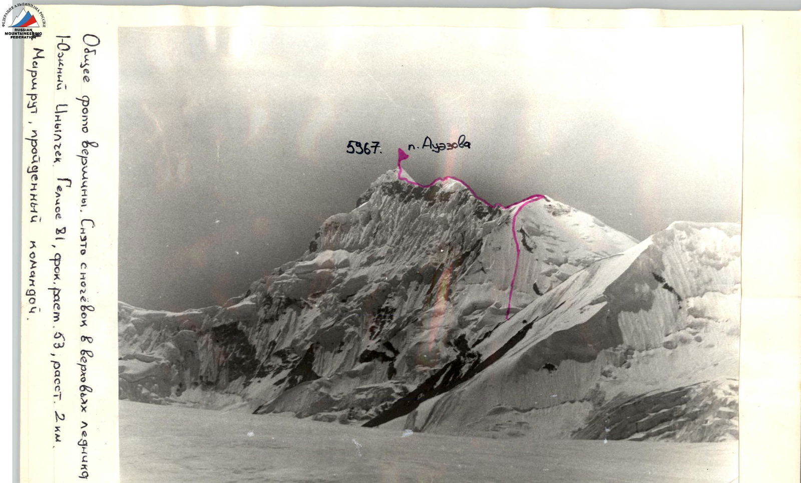
General photo of the summit. Taken from the overnight stays in the upper reaches of the South Inylchek glacier. Helios 81, focal length 53, distance 2 km. Route taken by the team.
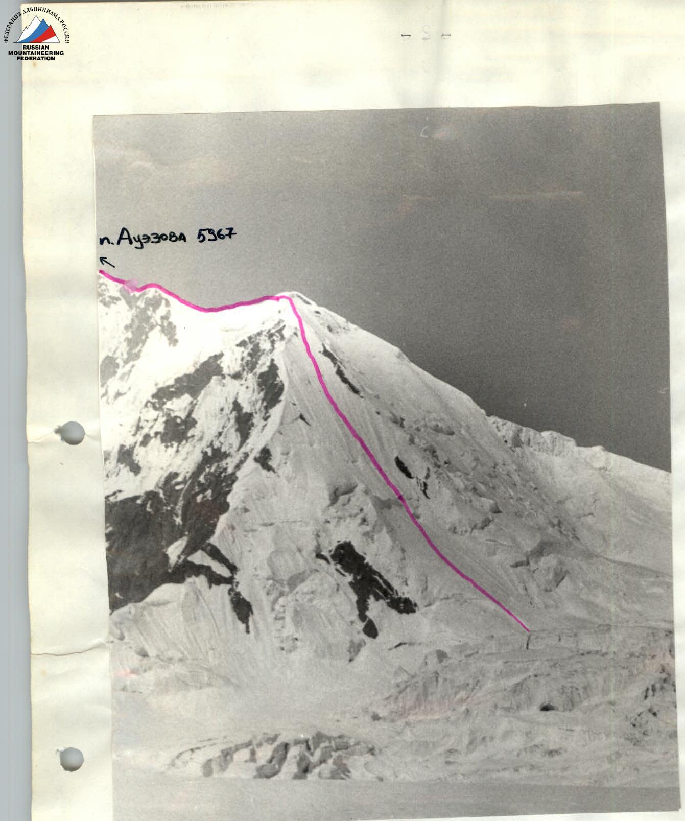
Profile of the wall from the left. Taken from the overnight stays in the upper reaches of the South Inylchek glacier. Helios 81, focal length 53, distance 2 km.
Tactical Actions of the Team
The Eastern wall of Peak Auézov (5967 m) was chosen as the object of ascent within the framework of the USSR Championship in mountaineering in the snow and ice class based on photographic materials. On July 31, 1989, the team approached the wall to choose the ascent route and scout the descent path. On July 31, 1989, and August 1, 1989, the wall was observed by the team members through binoculars from a distance of 1–2 km. As a result of these observations, it was concluded that all routes near the center of the Eastern wall of Peak Auézov are objectively hazardous due to firn "growths" hanging above all routes in the upper part of the wall, measuring several tens of meters. The fall of some of these was observed during the reconnaissance sortie. In connection with this, a route along the ice "board" in the right part of the wall was chosen for the ascent within the framework of the USSR Championship.
A movement tactic was developed, which involved simultaneous movement of rope teams and interaction through screwed-in pitons.
To scout the descent path from the summit, the team made an ascent to the Maylin pass (5200 m) with an overnight stay near the pass. As a result, the descent path was studied.
Since the area of Peak Pobeda is known for its unstable weather, it was decided to traverse the "board" in less than one day, so that in case of deteriorating weather, the team would have the possibility to continue moving towards the summit along the ridge section of the route. This plan was fully implemented.
Leaving the camp under the wall (4700 m) at 7:00, the team, in full accordance with the tactical plan, stopped for the night on the ridge at 16:00 and explored the ridge for a distance of up to three ropes. By morning, the weather deteriorated: snowfall, visibility 30–100 m. Under these conditions, the ridge section of the route to the summit was traversed without risk of losing the route.
On the route, the rope teams moved simultaneously. The lead in the team was periodically changed.
The last 2 ropes of the "board" and the sharp ridge (with cornices to the left and a steep, up to 50°, slope to the right) were characterized by increased avalanche danger, which required special care in organizing belays and accuracy in movement. The team successfully coped with these tasks.
The descent from the summit was carried out along the scouted path in 3 hours 30 minutes.
During the movement, the team maintained stable radio communication with the observation group and the base camp. All scheduled radio communication sessions took place. The team used "Kaktus" radios.
On the route, the team had provisions at the rate of 350 g per person per day, plus an individual package of 50 g.
The equipment taken by the team on the route fully corresponded to the nature of the terrain and ensured its safe passage.
There were no falls or injuries during the team's movement.
Description of the Route by Sections
- R0–R1 Snow, in places up to 70 cm deep. In the upper part (in the area of ice dumps) up to 50° steep.
- R1–R2 Bergschrund and then an ice slope ("board") with a steepness of 45–50°. The ice is hard, "winter". It breaks off in lenses. Crampons slip on this ice; if they bite in, it's only to a small depth. In the upper part, a thin layer of dry snow lies on the ice. Under the snow, the ice is very hard; even very sharp crampons slip. The layer of snow increases and reaches 1 m before reaching the ridge, making the last two ropes of the section avalanche-prone. Movement in this part of the section requires special caution and thoroughness in organizing belays.
- R2–R3 Uncomplicated snow and ice ridge.
- R3–R4 Northern ridge of Peak Auézov. Cornices to the left.
- R4–R5 Rocky wall. The rocks are fragile.
- R5–R6 Dome of the subsidiary summit. The section is avalanche-prone.
- R6–R7 Ridge to the subsidiary summit. Large cornices to the left. To the right — a steep, avalanche-prone slope with a steepness of up to 50°. The snow is deep, in places up to 1 m. Movement requires great care, right along the line of cornice break-offs.
Route Diagram
Route diagram in IAA symbols. M: 1 cm = 40 m.
| Section | Cat. diff. | Length, m | Steepness | Height, m | Date |
|---|---|---|---|---|---|
| R0–R1 | 2 | 160 | 30° | 4700 | August 4, 1989 |
| R1–R2 | 1-5 | 765 | 48° | ||
| R2–R3 | 3 | 225 | 25° | 5556 | August 5, 1989 |
| R3–R4 | 4 | 240 | 25° | ||
| R4–R5 | 5 | 30 | 60° | ||
| R5–R6 | 4 | 90 | 30° | ||
| R6–R7 | 90 | 0° | 5967 |
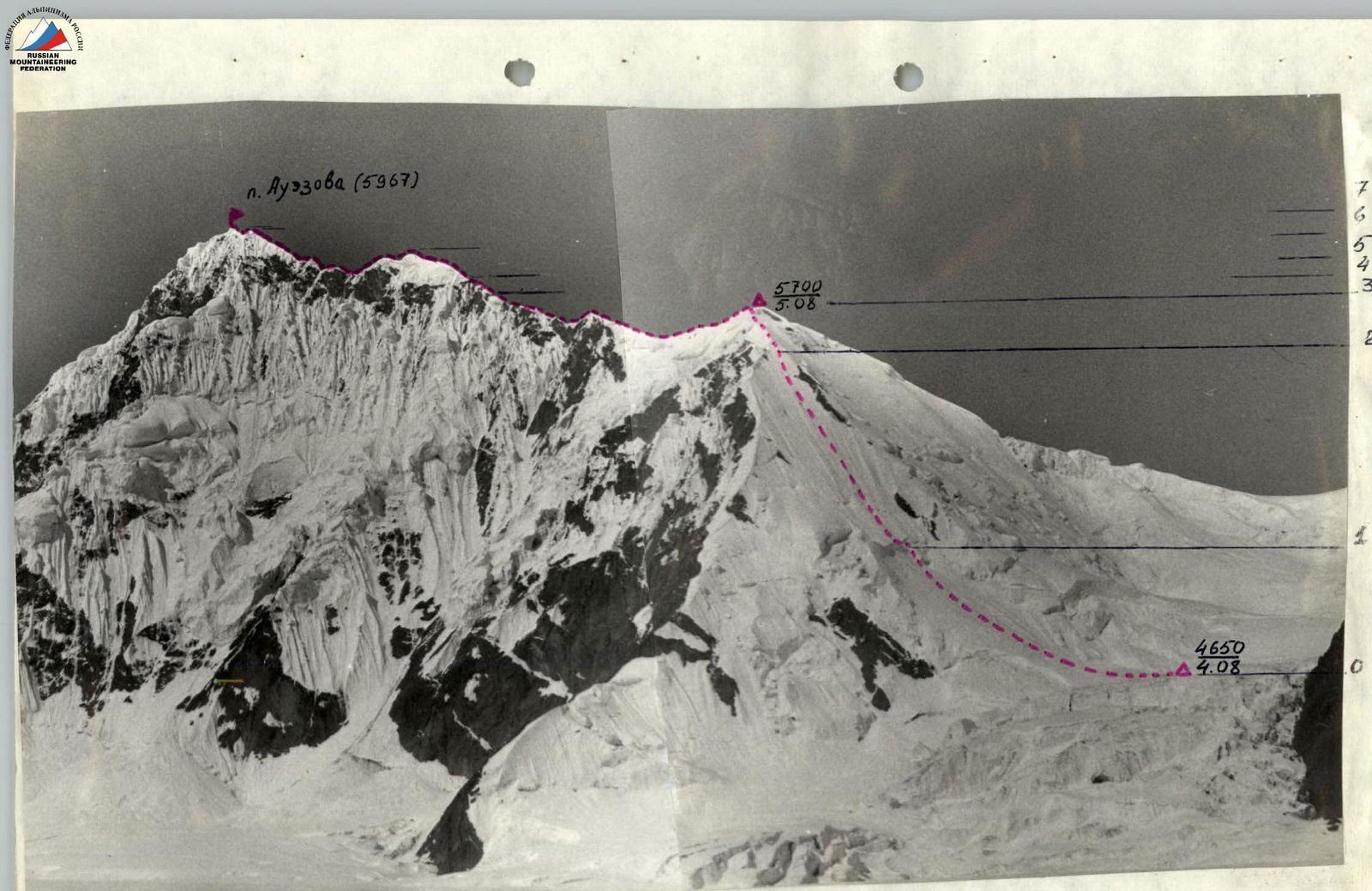
Technical photo of the route. Taken from the overnight stays in the upper reaches of the South Inylchek glacier. Helios 81, focal length 53, distance 2 km.