
Passport
- Category — technical.
- Tian Shan, Western Kokshaal-Tau.
- Peak Alpinist via the center of the NE wall.
- Proposed category: 6B, first ascent.
- Elevation gain 1219 m. Distance 1648 m.
Distance of sections with 5–6B category: 792 m, of which 415 m are category 6B. Average steepness of the main part of the route (4270–4930 m) is 70°.
- Pitons driven: rock, bolt, nuts, ice: 52/5, 0/0, 88/12, 24/0.
- Team's total time: 45 hours and 5 days.
- Overnights: 1, 2, 3 — on ledges, semi-sitting; 4 — on a snowy ridge, lying down.
- Captain: Lebedev M.V., Candidate Master of Sports.
Team members:
- Akhmatov F.A., Candidate Master of Sports
- Shamonov I.S., 1st sports category
- Korsun I.A., 1st sports category
- Coach: Kurshin A.P., Candidate Master of Sports.
- Route start — August 15, 1993. Summit — August 19, 1993. Return — August 19, 1993.
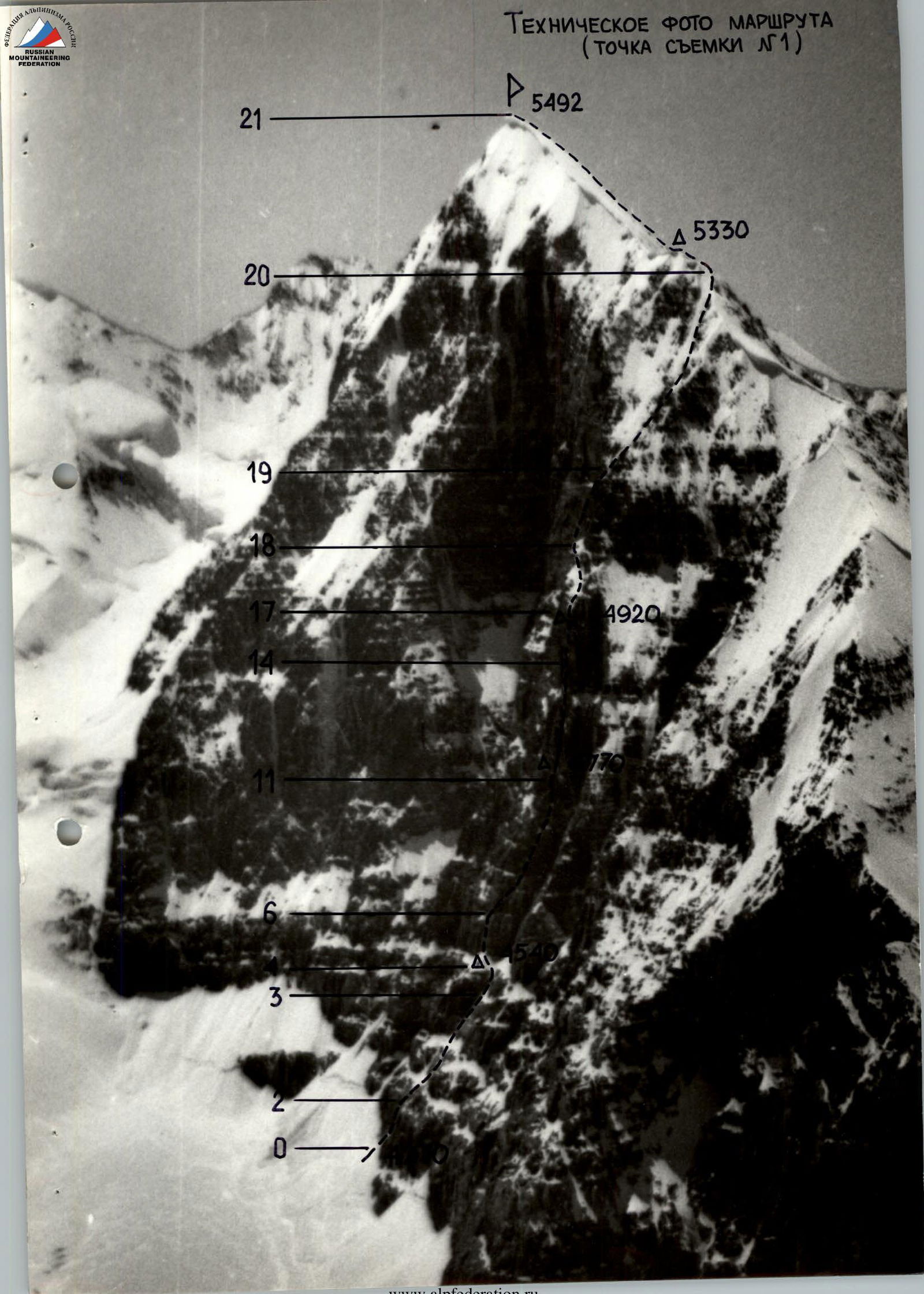
Technical photo of the route (shot point #1)
▲ 5330 21 20 19 18 17 14 11 6 3 2 0 5492 4920
Tactical actions of the team
August 15
At 7:00, the team left the observers' bivouac on the moraine of the Issledovatelei Glacier below the slopes of Peak Korolev. After crossing the glacier and ascending the snowy slope to the base of the central counterfort of the NE wall (the bergschrund was filled with snow and presented no difficulties), they began working on the route at 8:30.
Lebedev worked first. The steep, smooth rocks required the use of a double rope from the start. All team members, except the first, moved with top-rope protection. The first climbed in rock shoes.
After passing the first rocky belt, the team reached ledges before the next rocky ascent. The steep rocks of this ascent can be bypassed via a gentle snow slope. Choosing this path, the team transitioned to working in independent rope teams. Soon, it became apparent that despite the ease of movement on the chosen path, organizing protection was challenging. The "ram's foreheads" with few cracks, covered in snow and sometimes with ice, took a lot of time to find spots for pitons and nuts; ice screws were sometimes used.
It can be recommended to future climbers:
- to avoid bypassing the second rocky belt via snow;
- to tackle it directly.
Due to the stepped structure of the rocks, characteristic of the entire area, there were sufficient spots for overnight stays on the route. Reaching the top of the second rocky belt at 18:00, the team set up a bivouac. The comfort of the bivouac was significantly enhanced by a homemade tent made of lightweight nylon, with two side entrances, similar in size and design to a standard high-altitude tent but weighing only 2 kg. Simultaneously with setting up the tent, one rope was processed.
August 16
At 8:30, they dismantled the bivouac and continued on the route. Akhmatov worked first.
They moved on four ropes with top-rope protection for all participants except the first.
The complex rocks, sometimes covered with ice, required an optimal path. To achieve this, the lead climber often made short traverses to the right and left to scout out unseen options from the belay point.
It turned out that the most convenient path was along the most illuminated, protruding part of the counterfort. Moving slightly to the right significantly increased the amount of ice on the rocks.
On a purely icy section encountered on the way, Lebedev led, wearing crampons and carrying ice climbing gear.
At 18:30, they approached the steepest and most complex part of the route and set up camp for the night. One rope was processed (Akhmatov).
August 17
They packed up a cairn at the bivouac and started moving at 8:00. Akhmatov worked first, then Lebedev in the second half of the day.
The complex, smooth rocks with limited holds required the use of friends; ITO (artificial climbing aids) were used.
During the first's ascent of a complex pitch in the second half of the day, tea and snacks were organized.
They stopped for the night at 19:00 on a small ledge under an overhanging wall. There were 10 meters of complex climbing left to reach the large snow slope where the key part of the route ended.
In the evening, the weather deteriorated: snow fell, and visibility worsened.
August 18
The weather improved slightly by morning; the snow stopped, but the rocks were heavily snow-covered and wet. It was decided to tackle the remaining section using ITO. Lebedev worked first. After reaching the large snow slope, they transitioned to working in independent rope teams, using "rope team follows rope team" in complex spots to speed up. The terrain allowed the first climber to move in crampons and with a backpack.
The next rocky belt after the large snow slope, partly overhanging, was climbed via a previously scouted route — a system of ledges and couloirs crossing the rocky belt from left to right. Then, on a simple ridge, Korsun led. Moving simultaneously with protection over the ridge and rocky outcrops, they reached the northern ridge of Peak Alpinist.
After traversing 180–200 meters along the ridge, they stopped for the night. Snow and strong wind again.
August 19
Snow fell during the night and morning. Visibility in the morning was no more than 50 meters. Under these conditions, it was decided not to rush, waiting for the weather to improve. By 10:00, visibility improved, and the snow stopped. The team broke camp and continued along the northern ridge.
The main hazards on the ridge were:
- snow-ice cornices hanging towards Peak Korolev.
Soon, the snow layer on the ice became too thin, and all participants put on crampons. Korsun worked first. Ice screws were used for protection. They reached the summit at 12:30. The summit is a snow-ice dome. 1.5 ropes below the summit, on a rocky outcrop on the southern slope, a cairn was built, and a note was left. Then, the team began descending via snow fields, traversing them with a loss of height towards the SE ridge. Visibility was no more than 100 meters. Orientation in these conditions was aided by:
- regular radio consultations with Zueva's group;
- observers.
By evening, the weather improved. They were on the glacier by 19:20.
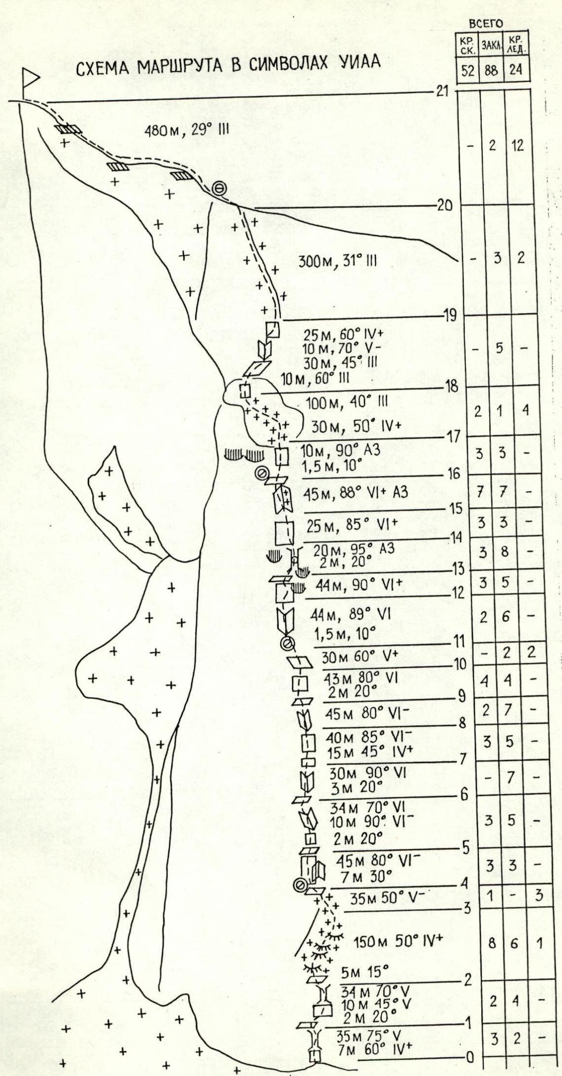
Route diagram in UIAA symbols
Total: Rock 52, Nuts 88, Ice 24.
Route description by sections
R0–R1. Chimney. In the depths, there is ice. Pleasant climbing but few spots for protection.
R1–R2. Chimney with smooth walls. Rocks like "ram's foreheads."
R2–R3. "Ram's foreheads" covered with snow and small stones. A lot of ice. Organizing protection is very challenging.
R3–R4. Ice. Reliable protection via ice screws.
R4–R5. Steep rocky ascent to the left of the inner corner. Small holds, mostly lateral. Few spots for pitons and nuts.
R5–R6. Steep, monolithic rocks, ice, ITO used in places.
R6–R7. Steep inner corner, climbed on the left side.
R7–R8. Complex climbing, partly with ITO.
R8–R9. Inner corner, movement on its left side.
R9–R10. Steep wall with ice on the right.
R10–R11. Steep ledge with ice; in the upper part, the ice layer is thin, but it's possible to place large nuts in the rocks.
R11–R12. Monolithic rocks with a limited number of holds. Wide cracks appear where friends fit well. Climbing is complex, partly on ITO.
R12–R13. Complex climbing. Movement first right-up under an overhanging cornice, then left-up to bypass the cornice.
R13–R14. Chimney with a plug, overhanging at the top. Ice. Passed on ITO in the upper part.
R14–R15. Smooth, very steep wall. The lower part is on ITO; the upper part is free climbing. Climbing is complex; the choice of holds is limited, but the rocks are monolithic, and there's no issue with protection — medium and large nuts, and thin pitons fit well. In the uppermost part, the rocks are wet.
R15–R16. Wide inner corner. A lot of ice on the rocks, especially on the right. Passed on the extreme left side, on the most illuminated spot. There are smooth, wide gaps without holds, conveniently passed on ITO using large friends. The section ends on a small, well-protected ledge. It's convenient and safe to overnight here. 10 meters above, on a large snow slope, there are no comfortable spots!
R16–R17. The section can be climbed free if the rocks are in good condition. If the rocks are wet or snow-covered, it's climbed on ITO. At the top, there's ice in the cracks.
R17–R18. Movement left-up to the start of a system of steep, diagonal ledges crossing the last rocky belt from left to right. In warm weather, there's a risk of falling rocks and icicles. Protection mainly via ice screws.
R18–R19. Relatively simple rocks but a lot of ice.
R19–R20. Simple ridge. Protection via outcrops and across the ridge.
R20–R21. Cornice ridge. In the upper part, there's hard ice. Movement in crampons, protection via ice screws. Summit.
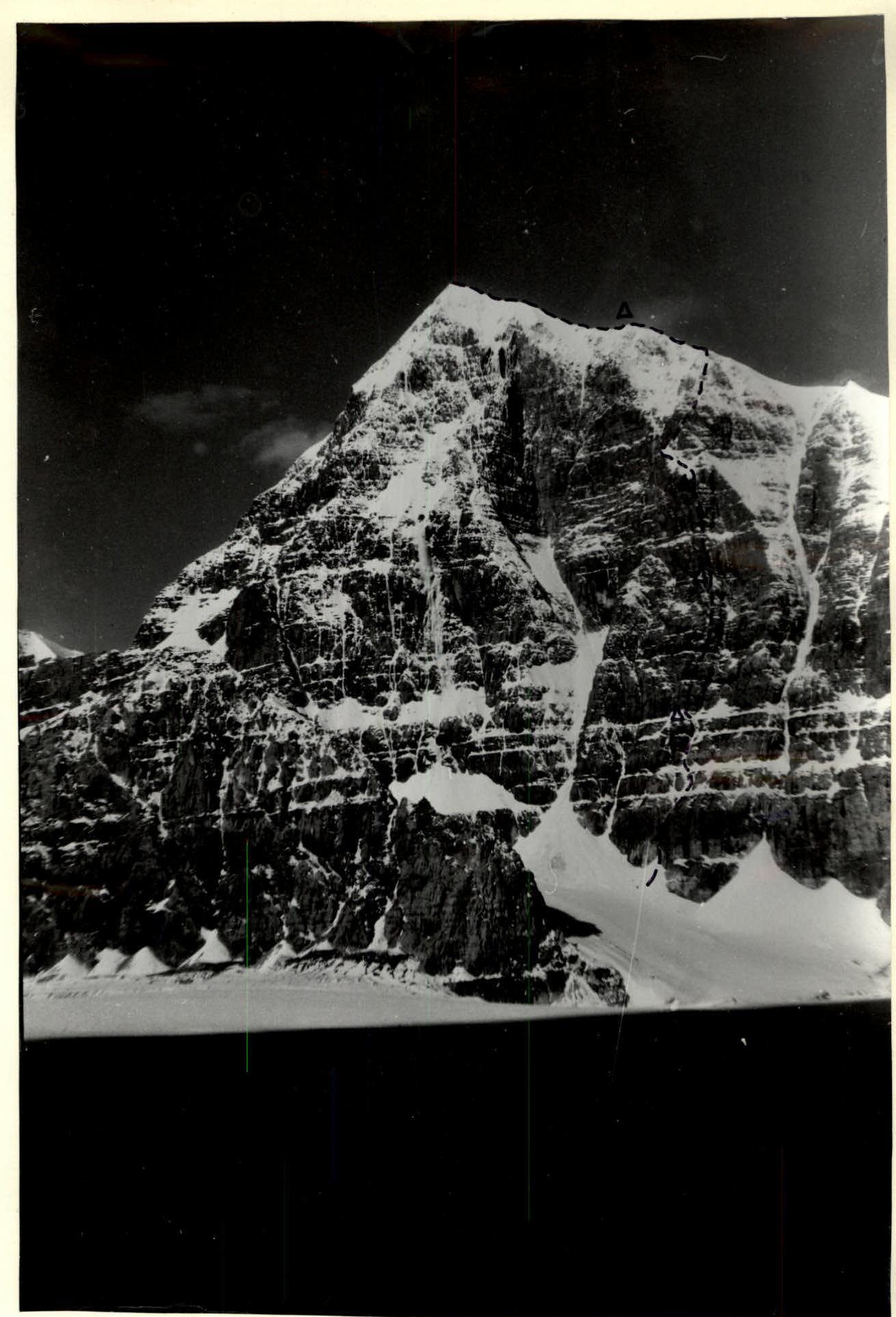
VIEW OF P. ALPINIST FROM THE OBSERVERS' CAMP (SHOT POINT #2)