Passport
- Technical category
- Tian-Shan, western Kokshaal-Tau
- Peak Alpinist via the ridge
- Proposed 5B category, first ascent
- Elevation gain 1220 m.
Distance 1970 m. Length of sections with 5th category difficulty 420 m. Average steepness of the main part of the route (4650–5190) 68°
- Pitons hammered in:
rock 17, chocks 26, ice screws 16
- Moving time 18 hours and days 3
- Overnight stays:
1st on a snow ridge — lying down 2nd on a hacked-out platform — semi-sitting
- Captain: Boyko V.V., Master of Sports
Team members: Vishnyakov V.I., Candidate for Master of Sports, Saliy R.L., 1st class
- Coach: Akhmatov F.A., Master of Sports
- Approach to the route — August 24, 1996
Summit — August 26, 1996. Return — August 26,
1996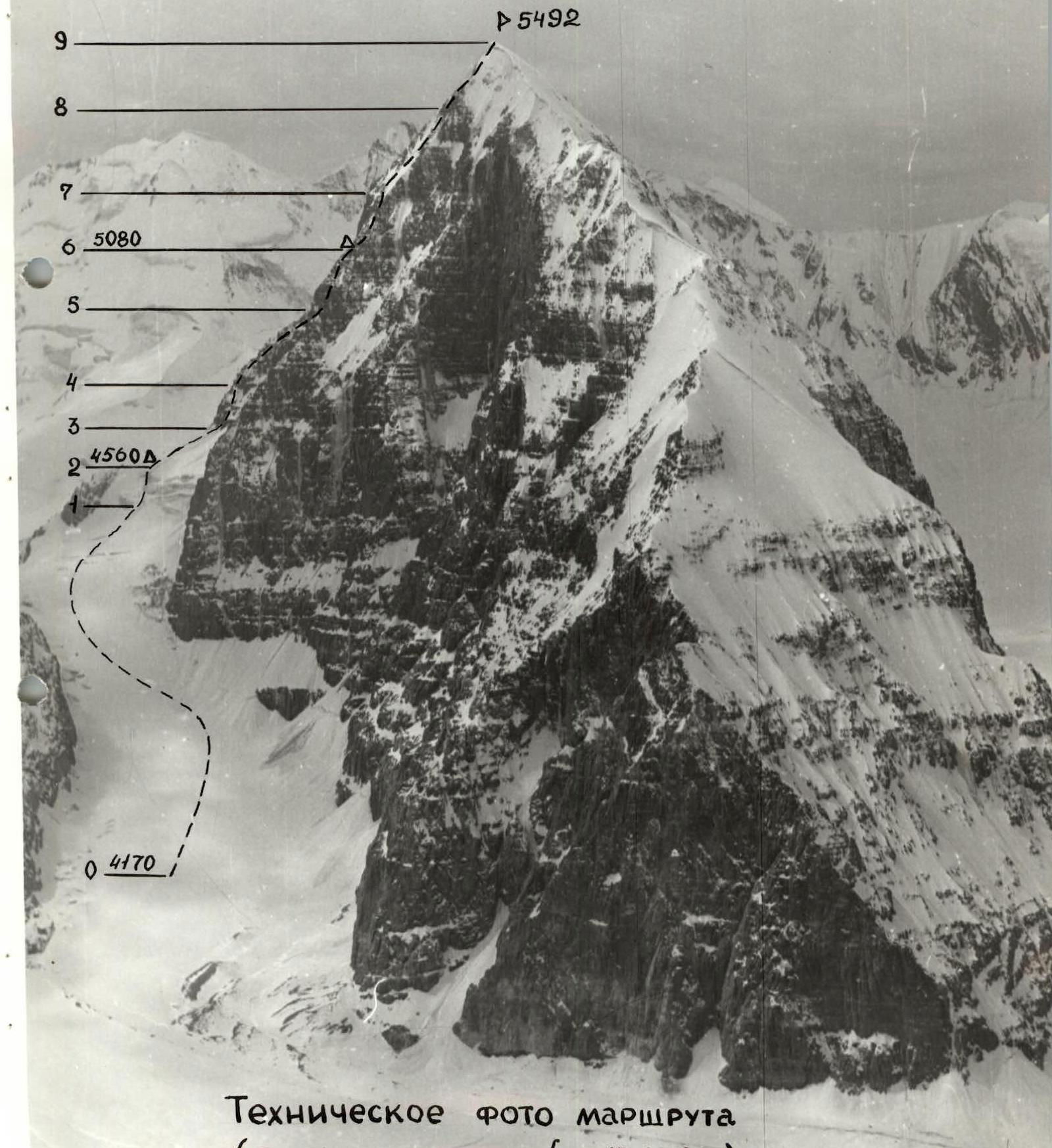
A
5492
 Technical photo of the route (shot from point #2 on August 15, 1996)
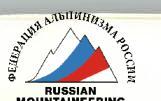
 Profile of the wall on the left (shot from point #5 on August 27, 1996)
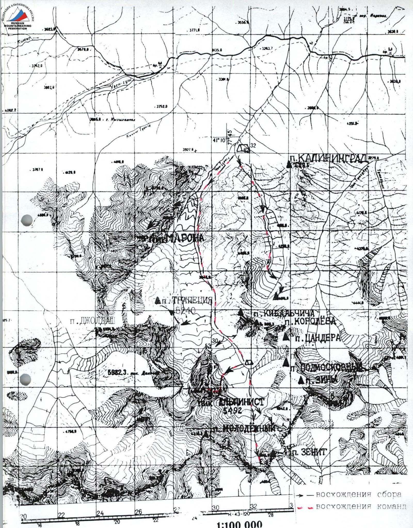
Schematic map of the ascent area M 1:100 000
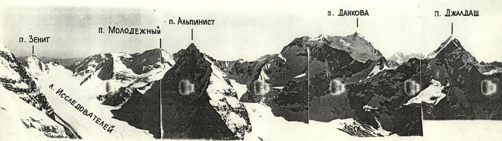
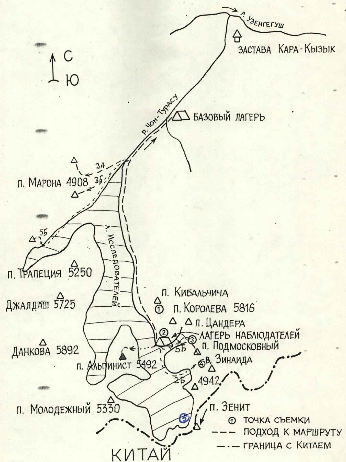 PHOTO PANORAMA OF THE ASCENT AREA (shot from point #1). Photo from 1969
Tactical actions of the team
August 24
- Movement in a rope team on a closed glacier on the 2nd rope.
- Saliy, who was leading, fell into a crevasse once but successfully climbed out using jumar ascenders.
- The ice wall before the saddle required caution due to snow cover.
- The overnight stay on the saddle is safe and comfortable.
August 25
- Movement in a rope team. The leader went with a maximally lightened backpack and left it to the team members in several places.
- On some sections, the movement was simultaneous with belaying through outcrops and chocks.
- Due to the severe degradation of the ridge, the leader tried to move diagonally to ensure the safety of the lower team members. Sometimes this required moving along a more complex path.
- Ice screws did not go all the way into the serac ice, and quickdraws were used, which were attached to the piton with a sling.
- Due to the icing of many sections, almost all the time was spent climbing in crampons.
- The second overnight stay — semi-sitting on a small hacked-out platform — is relatively safe, but all team members slept with a belay and wearing helmets.
- We stopped for the night early due to bad weather.
August 26
- We ascended to the summit lightly, leaving all unnecessary gear in the tent.
- Descent was made along the ascent route, and the pre-placed loops helped.
- On steep ice sections during the descent, self-extracting ice screws were used.
- Communication was regular via Motorola UHF radios.
- A pair of observers was stationed on the Researchers' Glacier.
- Under Peak JalDash, an interaction group was sitting, which started ascending when the team began descending. Thus, they acted as an advance rescue team.
- Additionally, a doctor and a resting group were in the base camp, who could provide assistance in case of an emergency.
Route diagram in UIAA symbols
Total: rock 17, chocks 26, ice screws 16
| Section | Length | Steepness | Category | Rock | Chocks | Ice |
|---|---|---|---|---|---|---|
| H = 5492 m, T = 4 h | ||||||
| R8–R9 | ≈200 m | 50° | 3 | – | – | – |
| R7–R8 | ≈350 m | 60° | 4 | – | – | 5 |
| H = 5080 m, T = 9 h | ||||||
| 80 m | 75° | 5 | 3 | 4 | 1 | |
| 30 m | 45° | 3 | ||||
| R5–R6 | 40 m | 85° | 5 | 6 | 11 | 1 |
| 40 m | 75° | 5 | ||||
| 70 m | 70° | 5 | ||||
| R4–R5 | ≈230 m | 60° | 4 | 4 | 6 | – |
| R3–R4 | ≈30 m | 75° | 5 | 4 | 5 | 3 |
| ≈30 m | 80° | 5 | ||||
| ≈30 m | 75° | 5 | ||||
| H = 4560 m, T = 5 h | ||||||
| R2–R3 | ≈180 m | 50° | 3 | – | – | 2 |
| R1–R2 | ≈80 m | 80° | 5 | – | – | 4 |
| R0–R1 | ≈500 m | 50° | 3 | |||
| R0 |
Description of the route by sections
R0–R1
- Movement on a closed glacier with a search for bridges over crevasses.
- Caution: rocks and ice are falling from the wall on the right.
R1–R2
- Ice wall covered with a layer of fresh snow (10–15 cm), which creates additional difficulties during the ascent.
R2–R3
- Under the rocky bastion and up to the right towards the bergschrund.
R3–R4
- 3-meter bergschrund is traversed by climbing.
- Up and to the left is a snowy ice wall turning into rocks covered with flow ice.
- Ice is thin and breaks off in lenses.
- Difficult climbing, hard to organize belay.
- Then — destroyed rocks, partly iced, with many loose stones.
R4–R5
- Destroyed ridge.
- A series of small walls, chimneys, crevices, partly iced and snowy.
- Generally, the path is logical, but variations are possible when passing individual sections.
R5–R6
- The nature of the terrain remains largely the same, but the steepness increases, and climbing sections from ledge to ledge become longer (10–30 m).
- However, the rocks are more monolithic.
R6–R7
- A small ice-snow ridge, at the beginning of which a platform for a tent was hacked out.
- Then — the same set of small walls and chimneys, partly iced.
R7–R8
- Up and to the left along the ice-snow slope towards the corniced ridge.
- Exit to the main ridge with the cutting through a small cornice.
R8–R9
- Up and to the right along the wide snow ridge to the summit.