Ascent Passport
- Region — Tian-Shan, Kyrgyz Ala-Too Range
- Pik Svobodnoy Korei 4740 m, center of the North face (Yu. Popenko)
- 6A category of difficulty
- Route type — combined
- Route characteristics:
Height difference (bergschrund 4100 m – summit 4740 m) — 640 m. Route length to the ridge — 870 m. Route length to the summit — 1070 m. Section lengths:
- 6 category of difficulty — 160 m
- 5 category of difficulty — 460 m. Average steepness to the ridge — 65°. Average steepness of the main part of the route (to the "roof") — 75°.
- Left on the route: pitons — 5, including drill pitons — 0.
Pitons used on the route:
- stationary drill pitons — 18, including TCO — 15 (all drill pitons were placed by the first ascent team)
- total TCO used — 86.
- Total climbing hours — 64, days — 8, including descent.
- Team leader — Ivanov Vitaly Borisovich, Candidate Master of Sports.
Team members: Titov Vadim Viktorovich — 1st sports category.
- Team coaches: Ivanov Vitaly Borisovich, Candidate Master of Sports
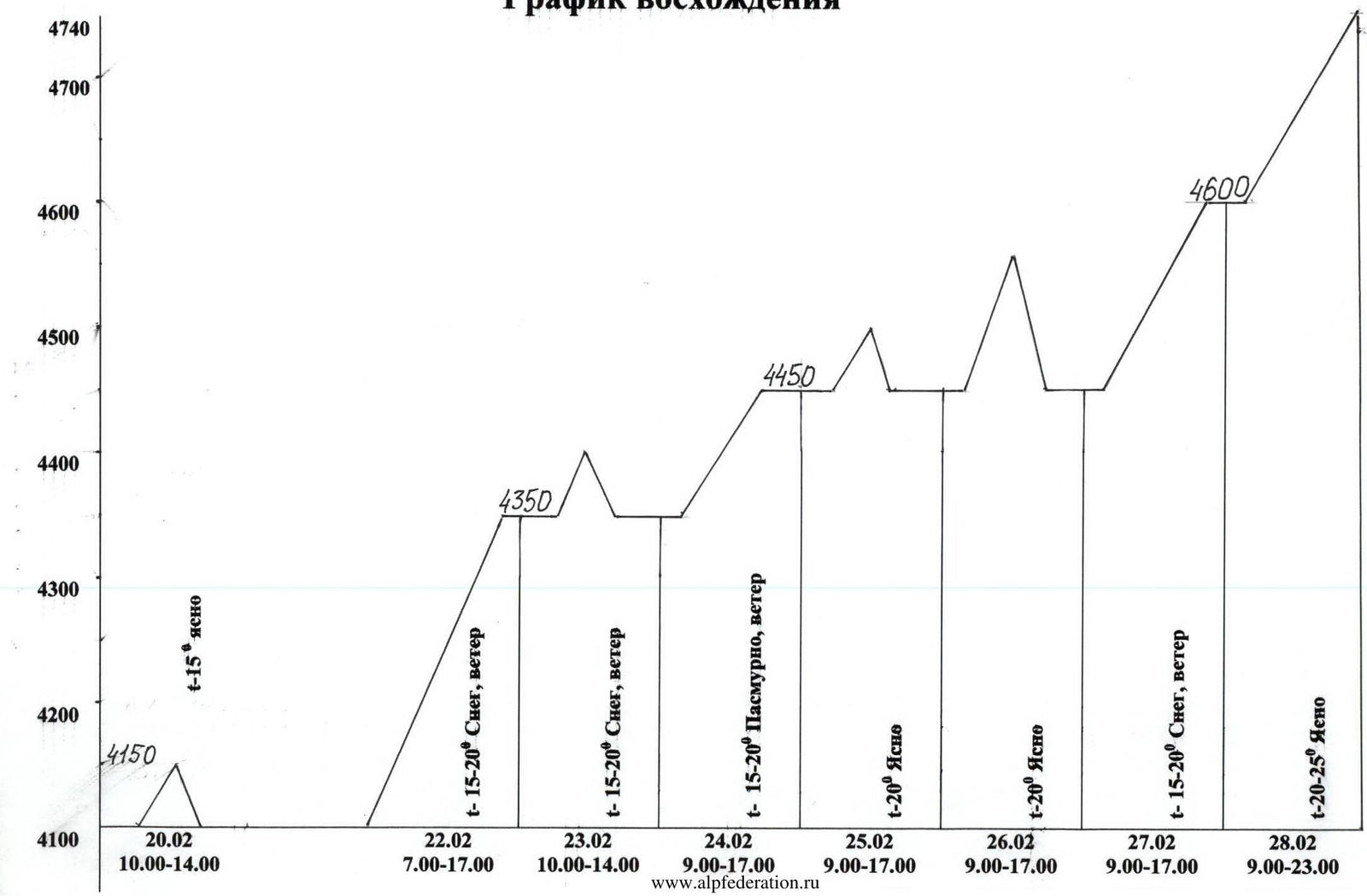
- Departure dates:
processing start — February 20, 2005 at 10:00; route entry — February 22, 2005 at 7:00; summit — February 28, 2005 at 16:00; return — February 28, 2005 at 23:00.
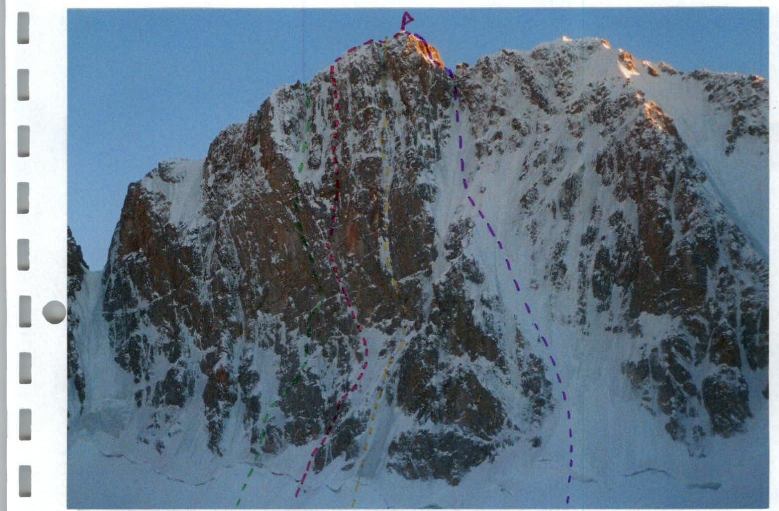
Photo #1. Photo of Pik Svobodnaya Koreya Team route (Popenko) Semiletkin's route Ruchkin's Barber's Photo taken on February 19, 2005 from Ak-Sai glacier.
Ascent Schedule
| Section # | Pitons | Ice pitons | Nuts | Drill pitons | UIAA symbol diagram | Length, m | Steepness, ° | Category of difficulty |
|---|---|---|---|---|---|---|---|---|
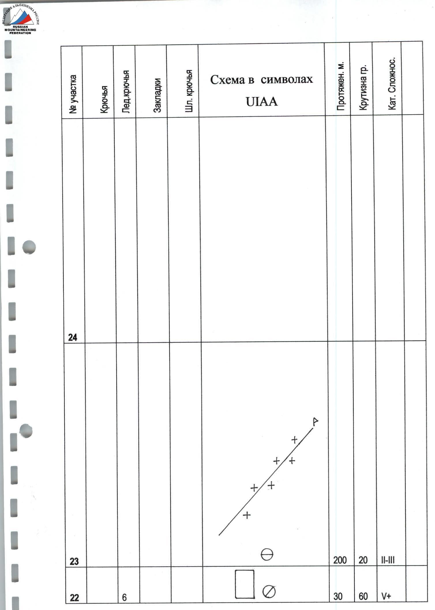
| 40 | 70 | |||||||
| R8 | 5/5 | 9 | 3/2 | 10 | 90 | |||
| 15 | 90 | |||||||
| R7 | 6/4 | 8 | 5/5 | Photo #5 | 35 | 60 | ||
| 25 | 80 | |||||||
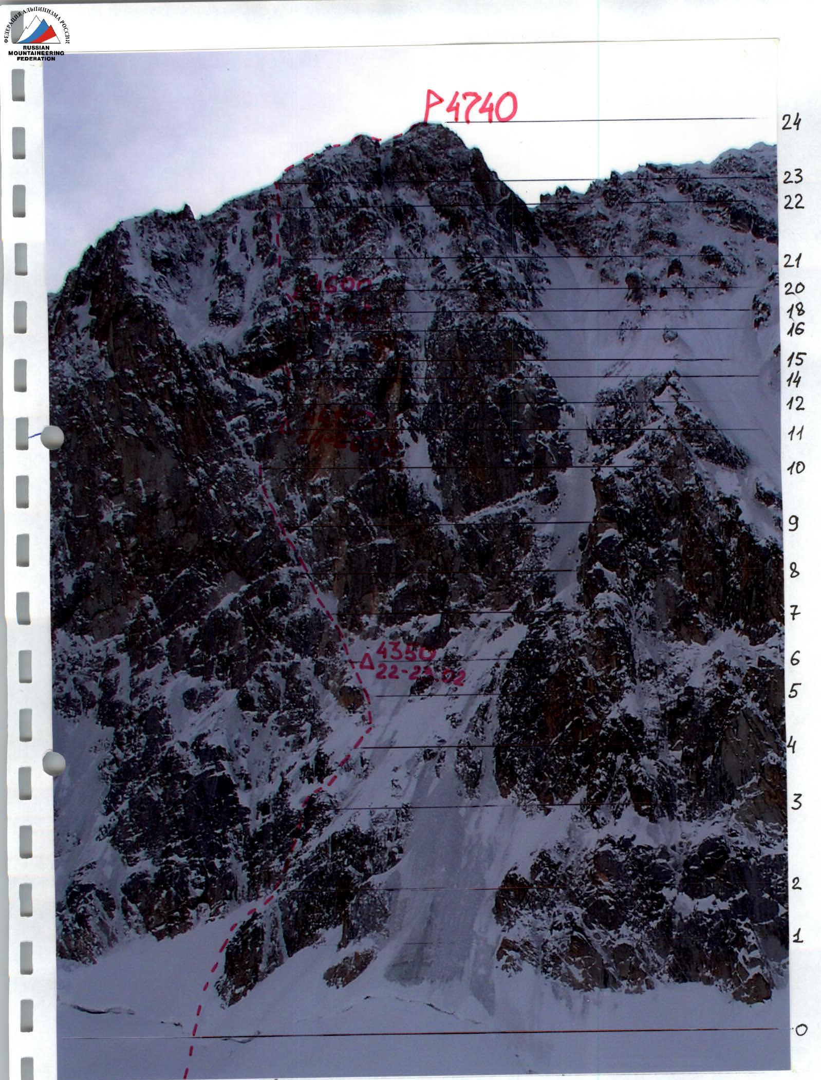
| R6 | 3 | 6 | 5 | Photo #4 | Overnight #1 | 25 | 70 | |
| R5 | 7 | February 22–23 | 25 | 70 | ||||
| R4 | 12 | 50 | 60 | |||||
| R3 | 11 | 50 | 60 | |||||
| R2 | 12 | 5 | 3 | 50 | 70 | |||
| R1 | 2 | 3 | 40 | 45 | ||||
| 45 | 50 | |||||||
| R0 | 10 | 5 | 90 |
M 1:2000
| Section # | Pitons | Ice pitons | Nuts | Drill pitons | UIAA symbol diagram | Length, m | Steepness, ° | Category of difficulty |
|---|---|---|---|---|---|---|---|---|
| R21 | 15 | 130 | 60 | |||||
| R20 | 2 | 6 | Photo #9 | Overnight #3 | 40 | 60 | ||
| R19 | 3 | 4 | February 27 | 15 | 70 | |||
| R18 | 8 | 50 | 60 | |||||
| R17 | 8/8 | 3/3 | 15 | 85 | ||||
| R16 | 10/10 | 15 | 85 | |||||
| R15 | 5/5 | 4/4 | 15/15 | Photo #8 | 35 | 110 | ||
| R14 | 5 | Photo #7 | 15 | 70 | ||||
| R13 | 1/1 | 2/2 | 3 | 110 | ||||
| R12 | 3/2 | 8/7 | 15 | 80 | ||||
| R11 | 4/3 | 3/3 | 3 | Photo #6 | Overnight #2 | 20 | 75 | |
| R10 | 7/4 | 6/3 | February 24–26 | 25 | 80 | |||
| R9 | 12 | 50 | 70 |
M 1:2000
M 1:2000
Technical photo of the route
February 28, 2005 A team of climbers from Bauman MSTU ascended Pik Svobodnaya Koreya via Barber's route, category 5B, consisting of:
- Novikov A. (leader)
- Sushko D.
- Prut O. Weather was sunny. At 9:30, a note from a team from Kazan (3 people) was found at the summit. Descent started at 9:35 via the ascent route. Our ascent is dedicated to the Aztecs!
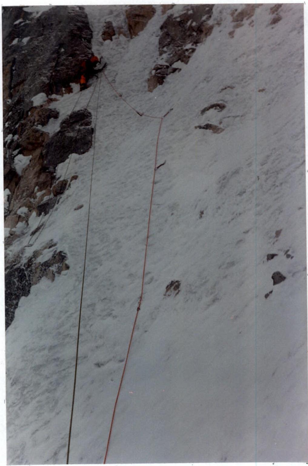
Photo 4. Passage of section R6–R7.
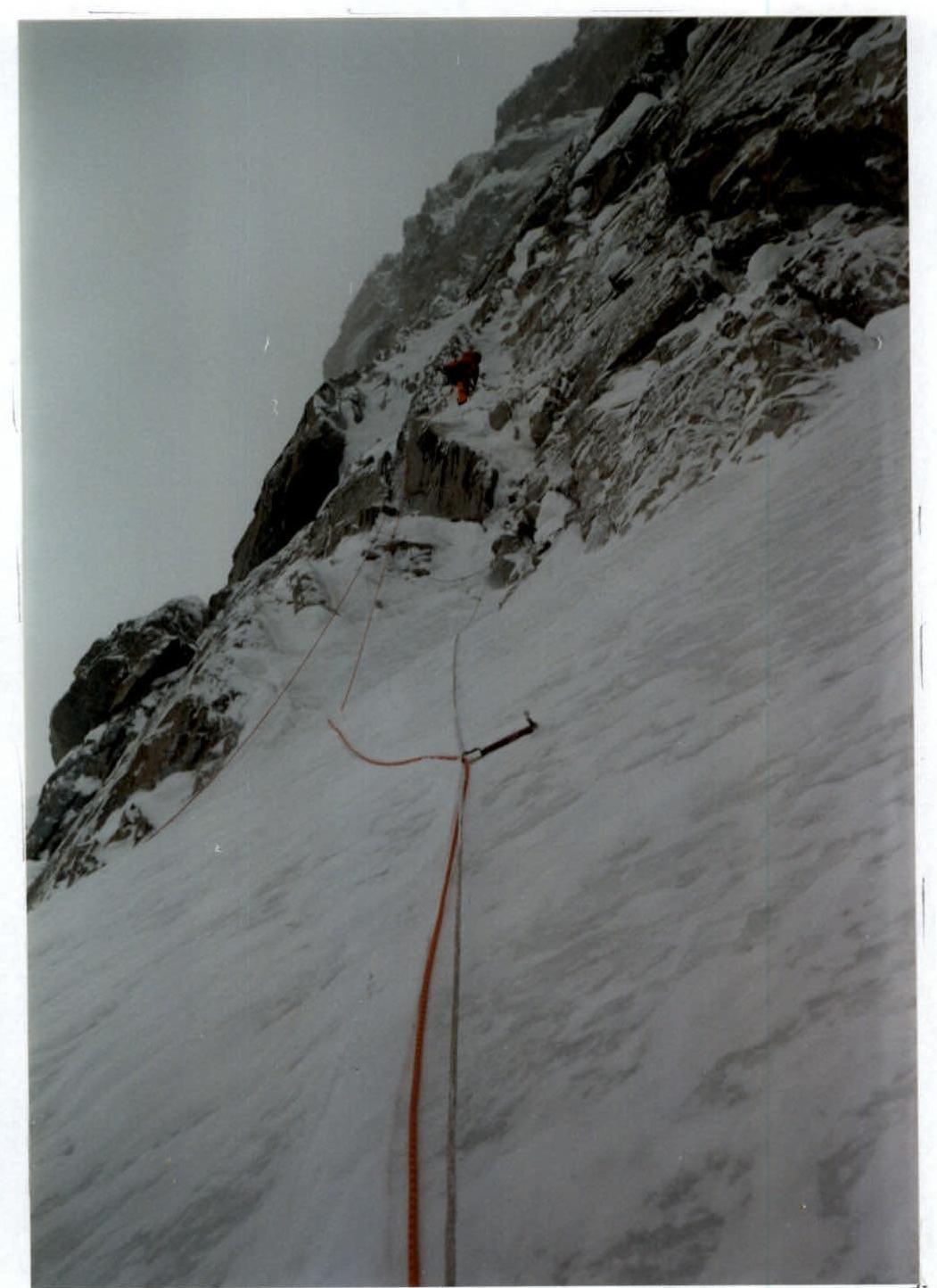
Photo 5. Passage of section R7–R8.
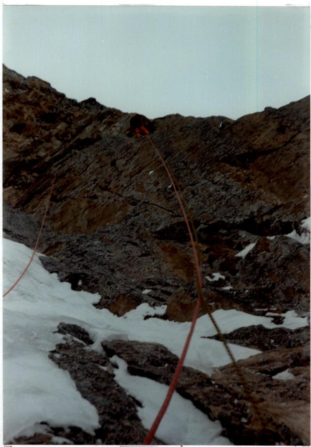
Photo 7. Roping along. Sections R13–R16.
Photo 8. Roping along. Beginning of section R15–R16.
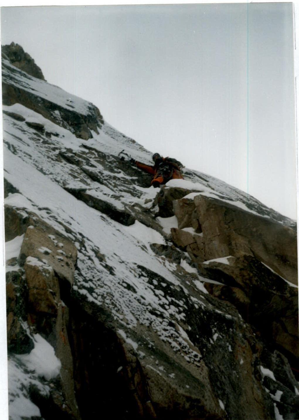
Photo 9. At the control cairn. Section R19–R20.
Route Description by Sections
| Section # | Description |
|---|---|
| R0–R1 | Bergschrund. Ice wall 5 m, followed by an ice slope. |
| R1–R2 | Snow and ice slope, leading to the rocks. |
| R2–R3 | Broken rocks consisting of walls and shelves covered with ice. |
| R3–R6 | Ice slope with embedded stones and rocky islands. At the end of the slope, a sitting bivouac was carved on an ice ridge. |
| R6–R7 | Beginning of a huge crack in the wall. Initially, an ice wall, then an internal corner filled with ice (ice thickness 5 cm), and topped with firm snow. |
| R7–R8 | Ice field leading to an internal corner filled with firm snow. Problematic spot for organizing belays. |
| R8–R9 | Internal corner with a thin layer of ice (3 cm). Belays are organized on rocks to the right and left of the internal corner. |
| R9–R10 | Ice slab leading to a rocky wall. |
| R10–R11 | Rocky wall with a small number of holds, leading to a shelf covered with ice and firm snow. After clearing the shelf from firm snow and ice, three drill pitons were found. The second sitting bivouac was set up on the shelf. |
| R11–R12 | To the right of the drill pitons, an internal corner. Passed with piton protection. |
| R12–R13 | Chimney, to the left a wall covered with ice. There are cracks for nuts and friends. |
| R13–R14 | Overhanging wall — cornice. Passed on anchor pitons and small stoppers. |
| R14–R15 | "Ram's foreheads". Slab with a small number of holds and cracks. When passing on TCO, drilling holes for skyhooks is required. We passed with free climbing using anchor pitons. The most difficult section of the route. |
| R15–R16 | Overhanging wall — cornice, drilled with pitons. Drill piton route of the first ascent team. Distance between pitons is large. Sometimes additional pitons or nuts, or series of them, are required. |
| R16–R17 | After the cornice, traverse right 5 m (crack for horizontal pitons) and exit to an internal corner with a good crack for medium-sized friends. |
| R17–R18 | Chimney leading to an ice slope. Beginning of the "roof". |
| R18–R19 | Ice slope with embedded stones or rocky wall covered with ice. |
| R19–R20 | Rocky wall leading to the control cairn. No note found in the cairn. A sitting bivouac was set up at the base of the wall. |
| R20–R21 | Rocky couloir, chimney filled with ice. |
| R21–R22 | Ice "river", slope, couloir. |
| R22–R23 | Ice and firm snow slope with embedded stones. Difficulties with organizing belays. |
| R23–R24 | Ridge. This year, there was a lot of snow on the ridge. |
Team Tactics
The ascent was completed without using a platform, which had a certain impact on the movement tactics. The transition from the first bivouac to the second was made only after processing and hanging ropes. The team had five ropes at their disposal, which allowed them to process four ropes above bivouac #1 and decide on the next bivouac, as there was no certainty about finding a shelf for a sitting bivouac. All bivouacs on the route were sitting.
The weather was generally favorable, except for three days:
- the first two
- the day before the last
The state of the route was very complex. In addition to everything being covered with a thin layer of ice (3–5 cm), it was all filled with firm snow. Literally every meter had to be cleared of hard snow during the ascent, which significantly reduced the speed of movement. Firm snow and hard snow did not allow for full use of ice axes, and ice sections, including vertical ones, were mostly passed with free climbing using ice tools.
On the route, the team:
- did not use skyhooks;
- did not drill new pitons, as the cornice was already drilled by the first ascent team.
The most difficult section (R14–R15) was passed with free climbing using anchor pitons.
February 20
Approach to the route. Processing the bergschrund. Carrying equipment, gas, and tent.
February 22
- Start on the route.
- Five and a half ropes of the rock-ice part were passed.
- Weather deterioration.
- Carved a platform in the ice slope for a sitting bivouac.
February 23
Bad weather. Snowfall and blizzard.
- Two ropes were passed.
- Overnight stay at the same location.
February 24
Two and a half ropes were passed.
- In the second half of the day, the bivouac was moved to a new location.
February 25
Processing a rope (50 m) above bivouac #2. Weather is favorable.
February 26
Processing:
- the cornice
- a rope above.
February 27
Snow, blizzard. Passing the processed part and exiting to the "roof". On the "roof" — approaching the control cairn, where no note was found. Overnight stay on an ice shelf carved in the slope.
February 28
Reached the ice "river" and then the ridge and summit. At 17:00, started descending via Barber's route and by 23:00 were at Koronskaya hut.