PASSPORT
- Technical class
- Tian Shan, Kyrgyzsky Ridge
- Peak Svobodnaya Korea, 4777 m, via the right bastion of the S wall
- Proposed — 6A category of complexity, first ascent
- Route characteristics:
| elevation gain | 670 m |
|---|---|
| length | 1270 m |
| length of section R5–R6 6 category | 555 m |
| average slope of the main part of route | 61° |
| of which 6 category 80° (sections R6–R12) |
- Pitons hammered in:
| rock | placements | ice |
|---|---|---|
| 62/17 | 85/29 | 53 |
-
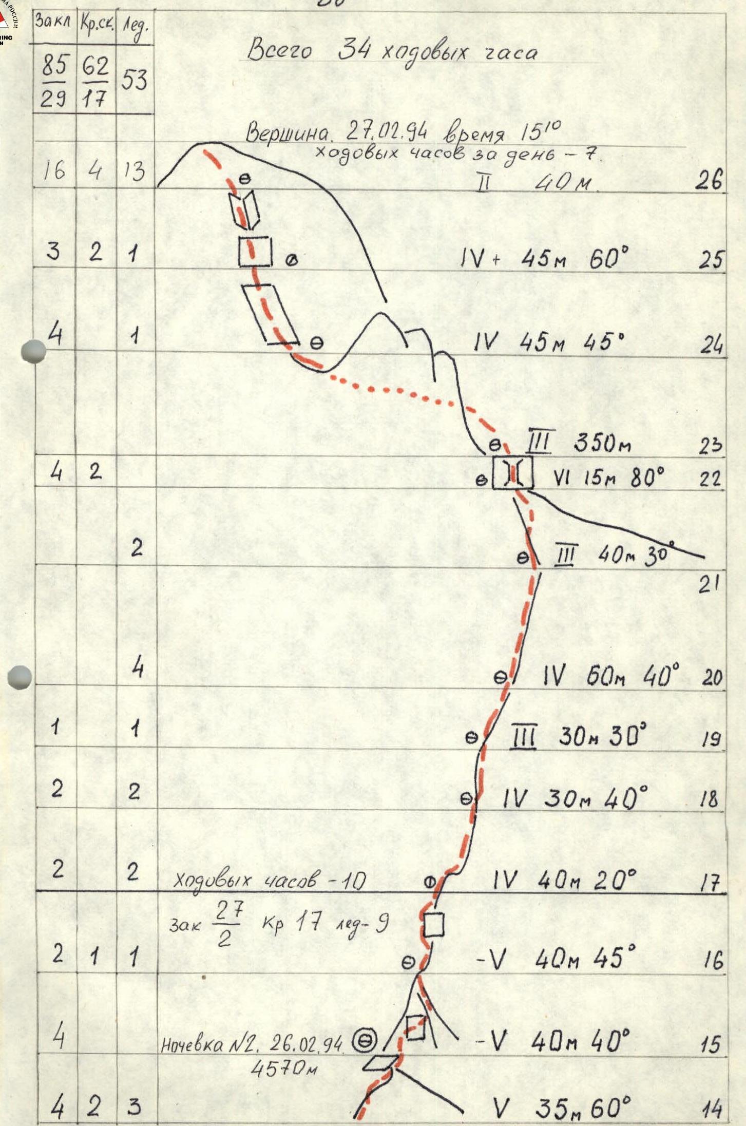
Climbing hours: 34, days: 3
-
Overnights: 1st in a tent set up on a platform 2nd in a tent set up on an ice-cut platform
-
Team leader: Balyazin Valery Viktorovich — International Master of Sports
Team members:
- Zakharov Nikolai Nikolaevich — International Master of Sports
- Kokhanov Valery Petrovich — Master of Sports
- Gulyaev Alexey Vladimirovich — Master of Sports
- Obednin Konstantin Alexandrovich — Candidate for Master of Sports
- Coach: Zakharov Nikolai Nikolaevich
- Approach to the route: February 25, 1994
Summit: February 27, 1994 Return: February 28, 1994
- Team of the Krasnoyarsk Regional Sports Committee
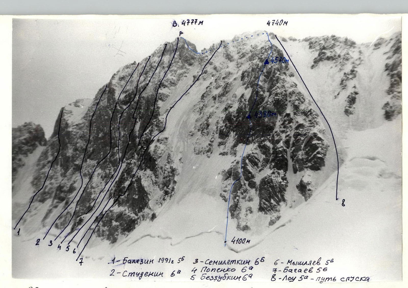
General photo of the summit. Taken on February 22, 1994 at 14:00. Lens F = 40 mm. Shooting point No. 1, distance 1 km. Height 4000 m — team’s route.
Routes:
- Balyazin's
- Studenin's 6A
- Semiletkin's 6A
- Popenko's 6A
Profile of the wall from the left. Taken on February 22, 1994 at 13:30. F = 40. Point No. 2, distance 600 m, height 4000 m.
Tactical actions of the team:
- The team went to work on the route, according to the tactical plan, on February 24 as a trio Kokhanov–Obednin–Gulyaev at 9:00.
- The lower ice section was processed, as well as 50 m of the rock bastion.
- Obednin worked first on the ice, Kokhanov on the rocks.
On February 25 at 7:00 the team in full strength left the hut, at 8:00 they began the ascent along the processed section of the route (section R0–R8). Having passed the processed section, the duo Balyazin — Zakharov went ahead, reaching the planned overnight location after 30 m of difficult climbing (section R8–R9). The duo continued further processing (section R9–R11), the remaining team members were hanging the platform for the overnight stay.
On February 26, they started moving at 8:00. The Kokhanov–Gulyaev team worked ahead.
Having reached the planned overnight location by 15:00, they began preparing the site for the overnight stay, and the Balyazin–Obednin duo continued processing the route (section R15–R17).
On February 27, having left at 8:00, by 13:00 the team reached the main ridge and at 15:00 reached the summit. The Zakharov–Gulyaev team worked ahead.
Difficult sections of the route R6–R8, R8–R9 due to the lack of good cracks for belays. Unusually cold winter, strong winds and snowfalls significantly complicated the ascent.
Throughout the entire route, the first climber moved on a double rope, and for the last one, a top rope belay was organized. For organizing overnight stays, the team had a platform.
The nutrition regime was as follows:
in the morning before departure — hot breakfast; during the day — lunch from individual packages and hot drinks from thermoses; in the evening — hot dinner. All equipment used by the team complies with UIAA safety standards.
During the team's movement, the rescue team located at the Koronskaya hut maintained communication with the team using the "Romashka" station according to the schedule 8:00, 12:00, 16:00, 20:00. Observers used binoculars. By agreement with the Kyrgyz Emergency Ministry, long-distance communication with Bishkek was established. The route was passed in the most difficult weather conditions safely, quickly, with a reserve of physical and moral strength.
Table of food and fuel products.
- Crackers 1 kg
- Roasted meat 0.5 kg
- Lard 1 kg
- Tea 0.1 kg
- Sugar 0.5 kg
- Sprats 3 cans 0.8 kg
- Buckwheat groats 0.5 kg
- Condensed milk 3 cans 1.5 kg
- Dried vegetables 0.5 kg
- Walnuts 0.4 kg
- Dried fruits 0.5 kg
- Rice 0.3 kg
- Petrol 1.5 kg
- Gas 0.5 kg
Total: 9.6 kg
The total weight of backpacks when entering the route, taking into account the equipment, was about 13 kg each.
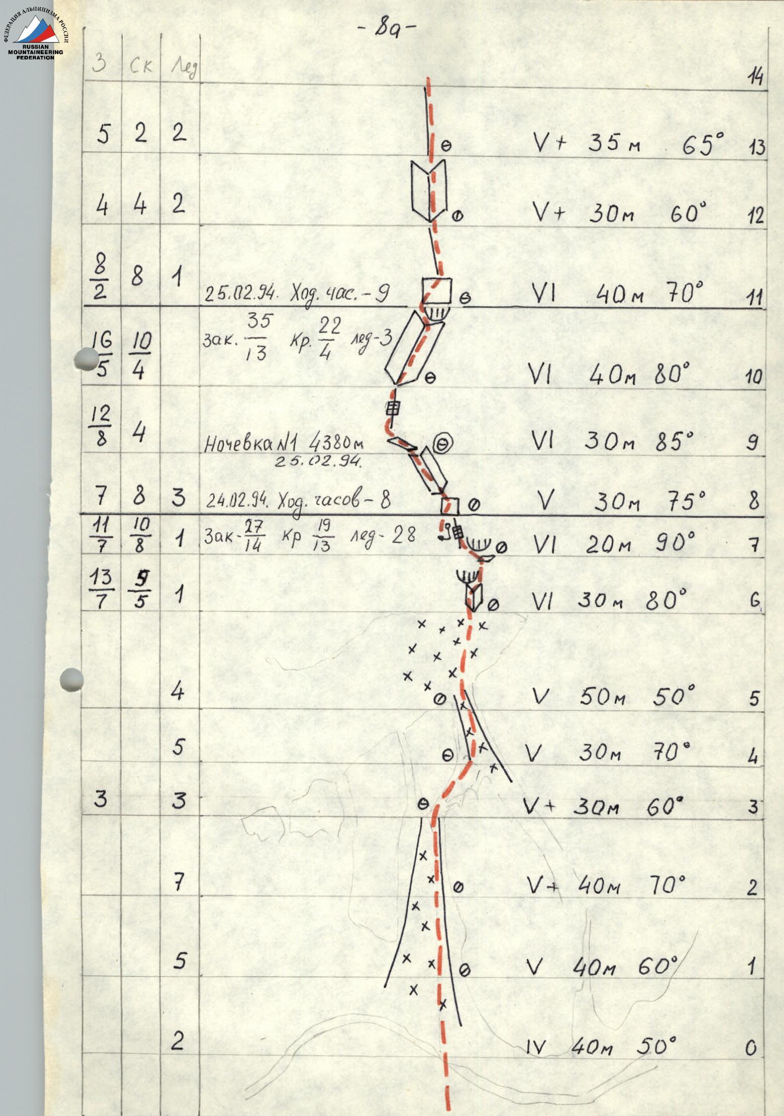
 Description of the route by sections.
Section R0–R1. Bergschrund, then firn about 20 m, then ice slope.
Section R1–R2. Ice slope. Ice is frozen, hard.
Section R2–R3. Ice with a steepness of about 70°.
Section R3–R4. Rock "feathers", slabs filled with ice, then ice groove.
Section R4–R5. Rock groove covered with ice.
Section R5–R6. Ice slope, in places the ice is covered with frozen snow.
Section R6–R7. Steep rock corner, very few cracks suitable for pitons and placements. Rocks are tile-structured with sloping ledges, in places heavily destroyed. The first cornice is bypassed on the right. Under the second cornice, there is a reception point on a good ledge.
Section R7–R8. Sheer wall, very few cracks for pitons. The cornice is passed on the left, then along a narrow destroyed crack to its end, then a pendulum to the left into an internal corner and along it to exit to a snow-ice patch.
Section R8–R9. From the snow-ice patch along an inclined internal corner filled with ice, from right to left. Overnight stay in a tent set up on a platform.
Section R9–R10. Sheer crack 2–4 cm wide, leading to a large internal corner.
Section R10–R11. Large internal corner going from left to right and leading up to the bastion, where there is a good ledge for organizing a belay.
Section R11–R12. Rock wall with sloping cracks, turning into a wide steep ridge, where it is very difficult to organize a reliable belay.
Section R12–R13. Steep internal corner filled with ice.
Section R13–R14. Steep, heavily snowed and iced rock ridge. At point 15 there is a platform for an overnight stay.
Section R15–R16. Heavily snowed ridge. The gendarme is bypassed on the right along the wall.
Section R16–R19. Snowy rock ridge.
Section R19–R20. Snow-ice ridge.
Section R20–R21. Rock ridge leading to the main, Western ridge.
Section R21–R22. Rock wall with a chimney.
Section R22–R23. Rock ridge. Gendarmes are bypassed on the right.
Section R23–R24. Summit tower.
Description of the route by sections.
Section R0–R1. Bergschrund, then firn about 20 m, then ice slope.
Section R1–R2. Ice slope. Ice is frozen, hard.
Section R2–R3. Ice with a steepness of about 70°.
Section R3–R4. Rock "feathers", slabs filled with ice, then ice groove.
Section R4–R5. Rock groove covered with ice.
Section R5–R6. Ice slope, in places the ice is covered with frozen snow.
Section R6–R7. Steep rock corner, very few cracks suitable for pitons and placements. Rocks are tile-structured with sloping ledges, in places heavily destroyed. The first cornice is bypassed on the right. Under the second cornice, there is a reception point on a good ledge.
Section R7–R8. Sheer wall, very few cracks for pitons. The cornice is passed on the left, then along a narrow destroyed crack to its end, then a pendulum to the left into an internal corner and along it to exit to a snow-ice patch.
Section R8–R9. From the snow-ice patch along an inclined internal corner filled with ice, from right to left. Overnight stay in a tent set up on a platform.
Section R9–R10. Sheer crack 2–4 cm wide, leading to a large internal corner.
Section R10–R11. Large internal corner going from left to right and leading up to the bastion, where there is a good ledge for organizing a belay.
Section R11–R12. Rock wall with sloping cracks, turning into a wide steep ridge, where it is very difficult to organize a reliable belay.
Section R12–R13. Steep internal corner filled with ice.
Section R13–R14. Steep, heavily snowed and iced rock ridge. At point 15 there is a platform for an overnight stay.
Section R15–R16. Heavily snowed ridge. The gendarme is bypassed on the right along the wall.
Section R16–R19. Snowy rock ridge.
Section R19–R20. Snow-ice ridge.
Section R20–R21. Rock ridge leading to the main, Western ridge.
Section R21–R22. Rock wall with a chimney.
Section R22–R23. Rock ridge. Gendarmes are bypassed on the right.
Section R23–R24. Summit tower.
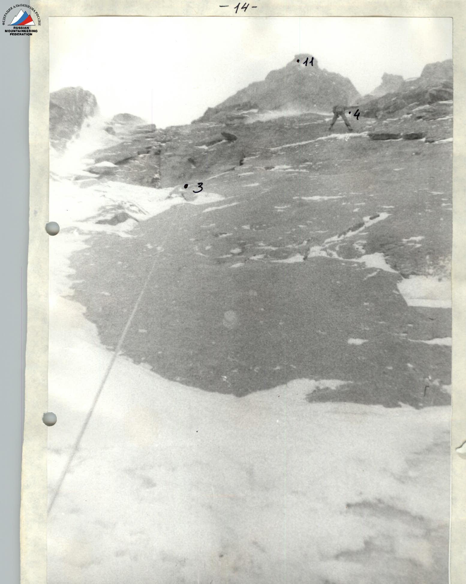
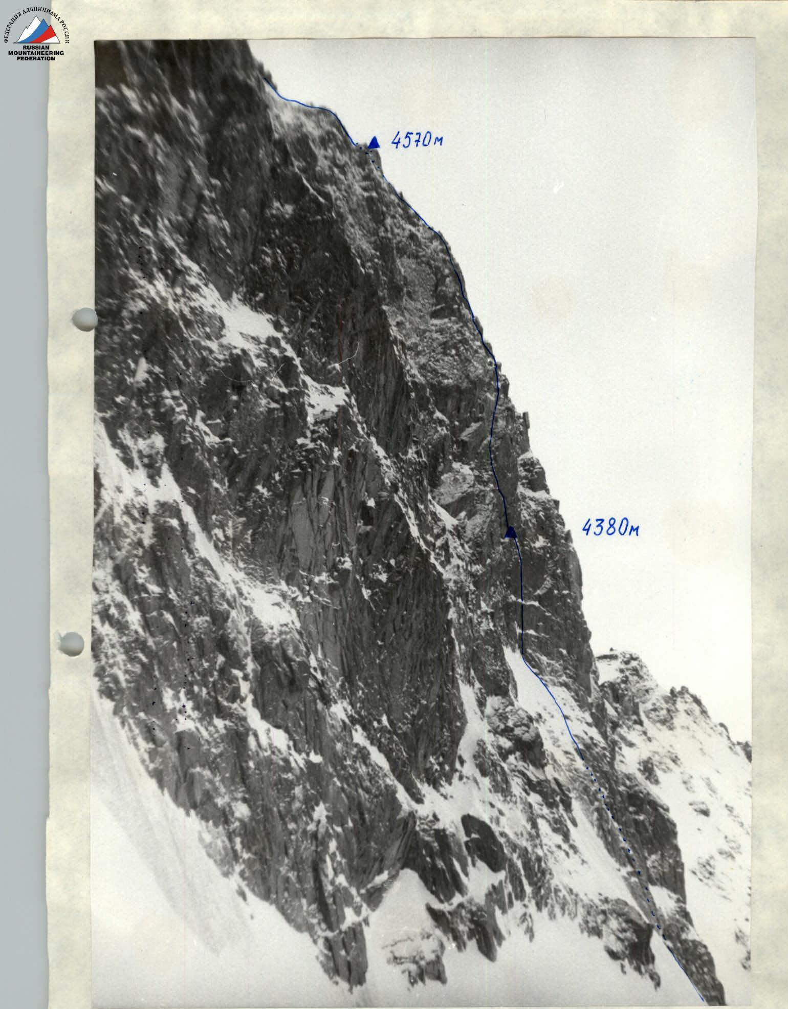
Photo No. 1. Taken from point 2. Camera "Smena", F = 40 mm. Passage of the first rock belt. Section R2–R4.
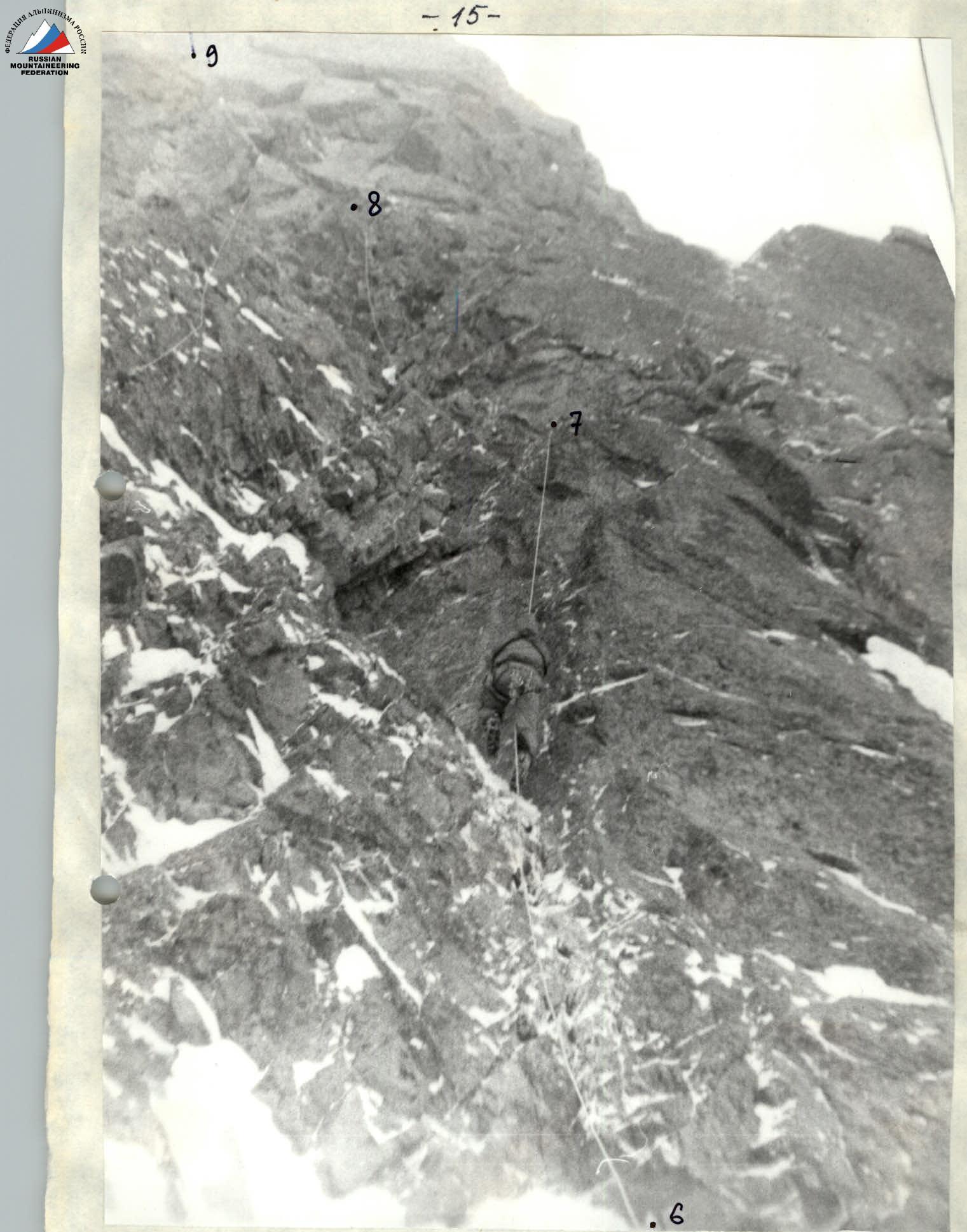
Photo No. 2. Beginning of the bastion. Taken from point 6. F = 40 mm.
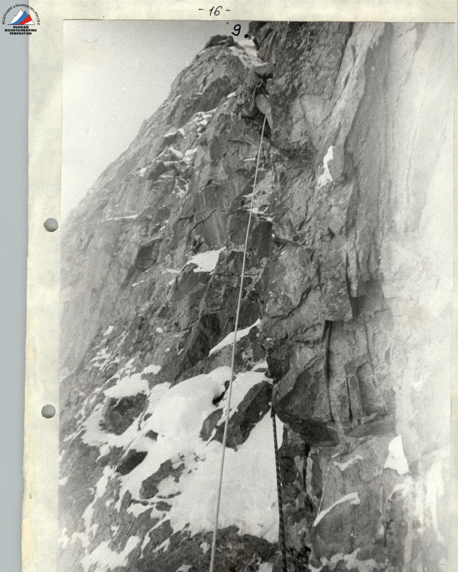
Photo No. 3
Passage of the iced corner of section R8–R9. Taken from point 8. F = 40 mm.