- Svobodnaya Korea peak, 4740 m, right of the left buttress of the North wall (2nd ascent) cat. diff.
- Team leader: Dashkevich S.A., Master of Sports
- Central Tien Shan. Kyrgyz Range. Aksay gorge.
- Section in Classification 7.4
REPORT
on the second ascent made by a team from the Federation of Alpinism and Rock Climbing of Sverdlovsk Region (FAIS of Sverdlovsk Region) to Svobodnaya Korea peak, 4740 m, right of the left buttress of the North wall. 6Az cat. diff.
Addresses:
620092, Yekaterinburg, Novgorodtseva st., 9/3, apt. 17 Dashkevich Sergey Alexandrovich Phone: 89122436251 Dash-sa@mail.ru Yekaterinburg 2010
Report on the ascent to Svobodnaya Korea peak
CONTENTS
- Ascent passport… 3
- General view photo of the peak… 4
- Brief description of the ascent… 5
- Note from the summit… 5
- Technical photo… 6
- Hand-drawn profile of the route… 7
- UIAA scheme… 8
- Route description by sections… 10
- Photos from the route… 12
1. ASCENT PASSPORT
Region — Central Tien Shan. Kyrgyz Range. Peak — Svobodnaya Korea, 4740 m, right of the left buttress of the North wall. Proposed — 6Az cat. diff. second ascent. Route type — combined.
Route characteristics:
height difference of the route — 643 m. height difference of the wall part of the route — 483 m. height difference to the ridge — 582 m. route length — 1070 m. length of the wall part of the route — 590 m. length to the ridge — 720 m. average steepness of the route — 44°. average steepness of the wall part — 68°. length of sections:
- 6 cat. diff. — 240 m.
- 5 cat. diff. — 200 m.
Left on the route: pitons — 0; chocks — 0.
Pitons used on the route:
- bolt — 2 (old);
- petal — 0;
- anchor — 2
Total FTO used — 0
Climbing hours to the summit — 14.5; with descent — 26.5; days — 1 Number of bivouacs — 0.
Team leader: Dashkevich Sergey Alexandrovich, Master of Sports.
Team members: Kabalin Gennadiy, 2nd sports category. Tretyakov Boris, 1st sports category.
Team coaches:
Pershin Valeriy Nikolaevich, Honored Master of Sports, Honored Coach of Russia
Departure dates:
for the ascent — March 1, 2010 to the summit — March 1, 2010 return — March 2, 2010
Organization: FAIS of Sverdlovsk Region.
2. General photo of Svobodnaya Korea peak, 4740 m. View from Koronskie bivouacs
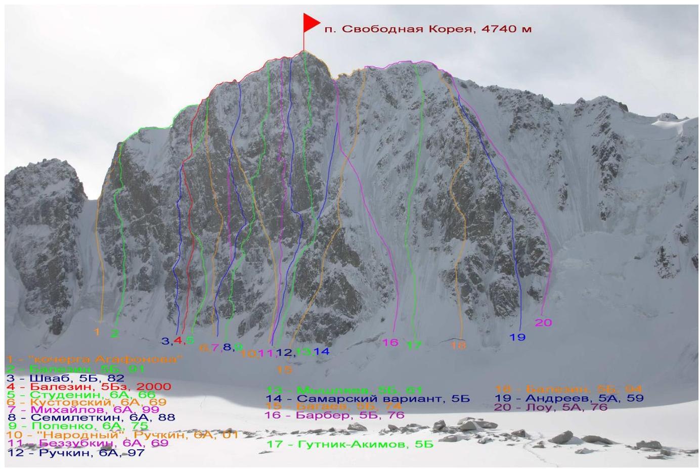
- "Agafonov's poker"
- via left triangle of N wall, 5B, V. Balezin, 1991
- via left buttress of N wall, 5B, A. Shvab, 1982
- right of the left buttress of N wall, 5Bz, V. Balezin, 2000
- via N wall to E ridge, 6A, B. Studenin, 1966
- via N wall to E ridge, 6A, A. Kustovsky, 1969
- via N wall, 6A, M. Mikhailov, 1999
- via N wall, 6A, S. Semiletkin, 1988
- via center of N wall, 6A, Yu. Popenko, 1975
- “People's”, 6A, A. Ruchkin, 2001
- via center of N wall, 6A, V. Bezzubkin, 1969
- via right part of N wall, 6Az, A. Ruchkin, 1997
- via right edge of N wall, 5B, L. Myshlyaev, 1961
- Samara variant of Barber's route
- via "triangle" of N wall, 5B, B. Bagaev, 1974
- via couloir of N wall, 5B, G. Barber, 1976
- Gutnik-Akimov route, 5B
- via center of NW wall, 5B, V. Balezin, 1994
- via NW wall, 5A, G. Andreev, 1959
- via couloir of NW wall, 5A, D. Lowe, 1976
3. Brief description of the ascent
Recently, ice climbing in Russia has reached a new level. Climbers now tackle routes previously considered unfeasible. Steep, overhanging rock walls are being climbed with ice tools. Winter free climbing of vertical and overhanging rock sections with personal protection is becoming a reality.
Valeriy Balezin's 2000 route on Svobodnaya Korea ascends the left part of the north wall. The route logically follows a series of ice couloirs separated by three rock belts. The complexity of individual rock sections reaches M6+. Protection on the rocks is sometimes problematic, with many large gaps without the possibility of organizing protection.
The first ascent team spent 6 days on the wall, actively using A2–A3+ artificial aids to overcome sections. We chose a modern lightweight style without using artificial aids, bolts, or fixed ropes. This simplification allowed us to move quickly and complete the route in one day. In case of an emergency, there was always the option to descend via the ascent route.
Balezin's route is essentially a more complex version of Studenin's route, classified as 6A. It is clearly more challenging than the popular winter route by Barber (5B) on the same wall, where no particular difficulties are observed. In this regard, the accepted classification of the route as 5Bz is unclear. Considering the winter conditions, this is undoubtedly a 6th category route.
4. Note from the summit
No note was retrieved from the summit due to the difficulty of finding it during winter.
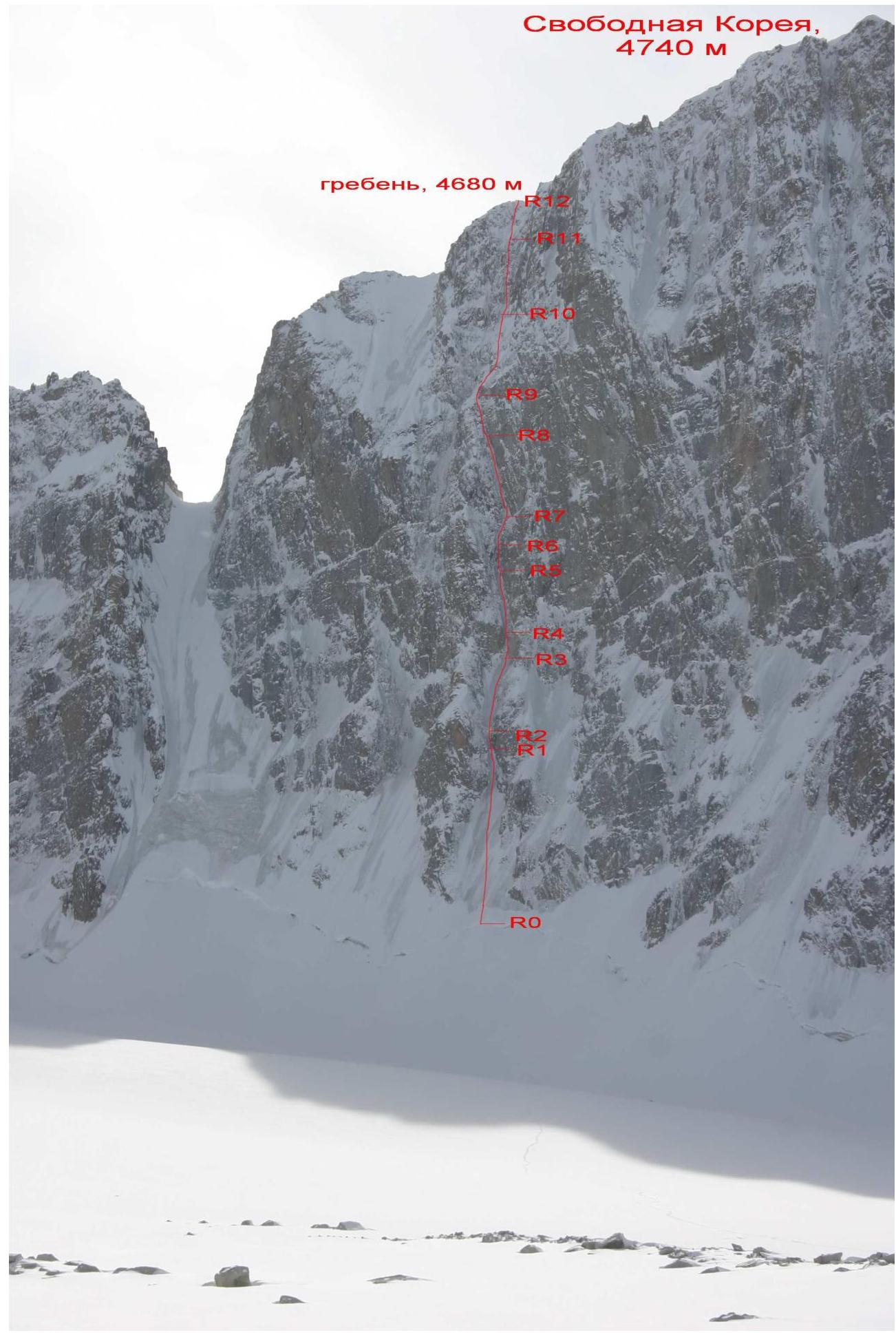
5. Technical photo
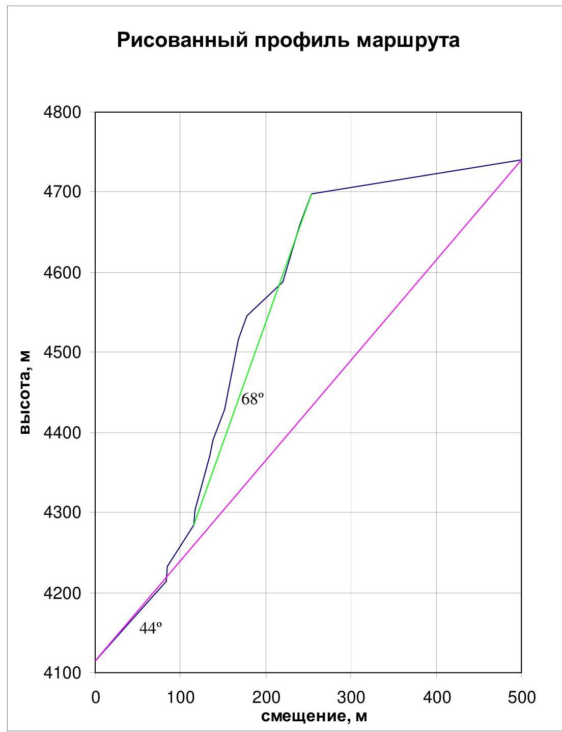
6. Hand-drawn profile of the route.
7. UIAA SCHEME
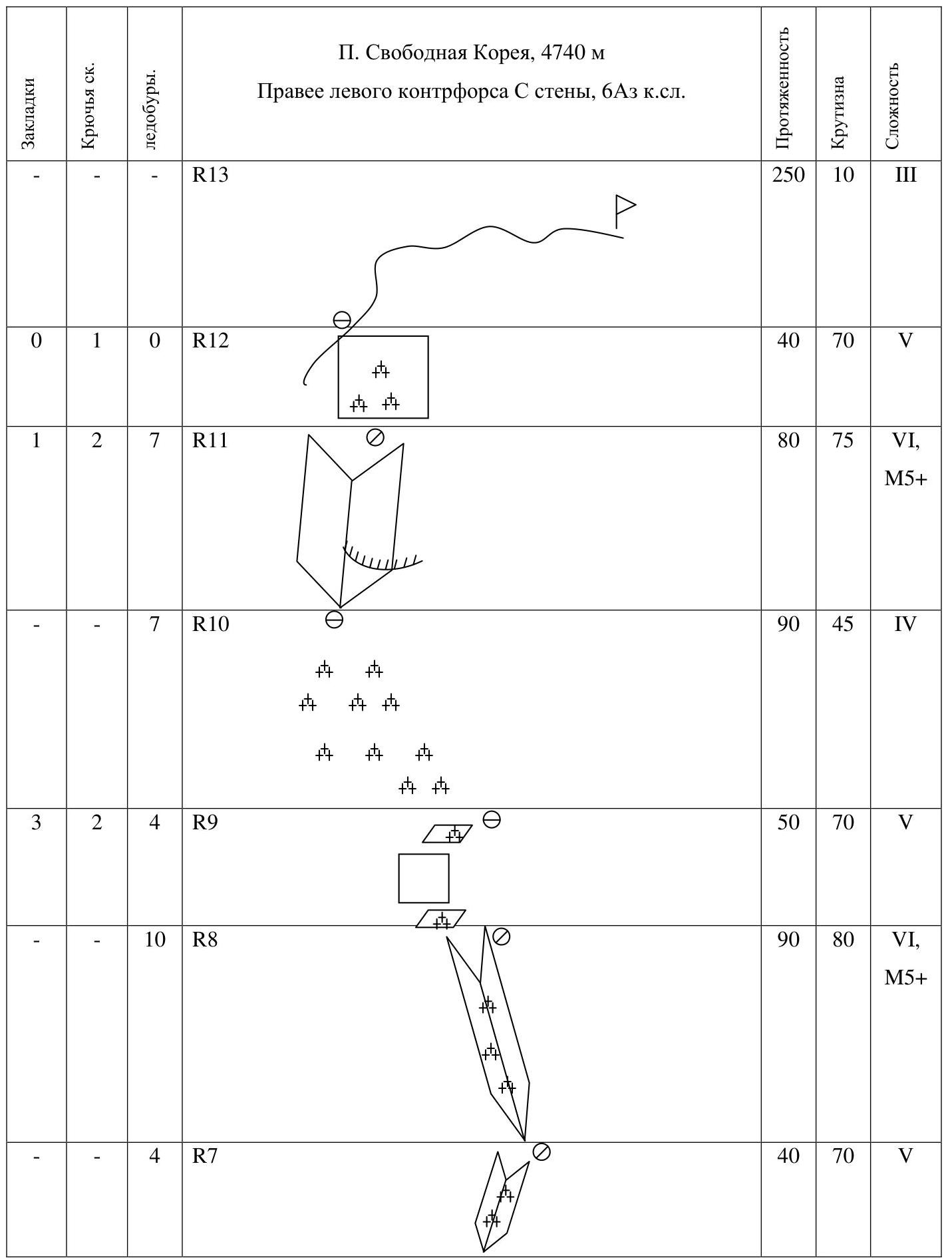
| Chocks | Rock Pitons | Ice screws | Section | Length | Steepness | Difficulty |
|---|---|---|---|---|---|---|
| R13 | 250 | 10 | III | |||
| 0 | 1 | 0 | R12 | 40 | 70 | V |
| 1 | 2 | 7 | R11 | 80 | 75 | VI, M5+ |
| 7 | R10 | 90 | 45 | IV | ||
| 3 | 2 | 4 | R9 | 50 | 70 | V |
| 10 | R8 | 90 | 80 | VI, M5+ | ||
| 4 | R7 | 40 | 70 | V | ||
| 3 | 4 | R6 | 30 | 80 | VI, M6– | |
| 8 | R5 | 70 | 75 | V, M4+ | ||
| 4 | R4 | 20 | 85 | VI, M5 | ||
| 5 | R3 | 60 | 60 | III–IV | ||
| 2 | 3 | R2 | 20 | 85 | VI, M6+ | |
| 9 | R1 | 130 | 50 | III–IV | ||
| R0 | 100 | 30 | II |
8. ROUTE DESCRIPTION BY SECTIONS
Section R0–R1. At the beginning of the section, the bergschrund was overcome using a "foothold" as everywhere there were hanging cornices. Next is an ice couloir narrowing towards the first rock step. In the narrowing, the last 30 meters, the ice steepness increases to 65°. 130 m, 50°, III–IV. Used: 9 ice screws.
Section R1–R2. First rock step, sheer wall. Heavily destroyed, the relief is characterized by "tile-like" rocks. Protection points are unreliable and limited. A fall is undesirable. The team passed this section on the right side (the first ascensionists went on the left), climbing is complex. 20 m, 85°, VI (M7–). Used: 3 ice screws, 2 cams.
Section R2–R3. Ice couloir, initially steep (~75°), then flattens to 50°. 60 m, 60°, III–IV. Used: 5 ice screws.
Section R3–R4. Second rock step, beginning of the wall part of the route. Sheer wall in the throat of a gully, climbing is complex, mixed terrain on thin ice and narrow ice streams. Protection points are rare, ice screws went in halfway. 20 m, 85°, VI (M5). Used: 4 ice screws.
Section R4–R5. Ice couloir. Streams are narrow, ice is thin. Ice screws go in halfway. Initially, the steepness is 80°, then it drops to 70°. 70 m, 75°, V (M4+). Used: 8 ice screws.
Section R5–R6. Third rock step. Steep, in places heavily destroyed wall, initially passed on the left, then a move to the right. Climbing is complex, on balance. For protection, 2 old bolts were used. On this section, there was a leader fall with a small swing (4 m) when attempting to climb the step directly. 30 m, 80°, VI (M6). Used: 4 ice screws, 3 cams, 2 bolts.
Section R6–R7. Inclined internal corner to the right, filled with ice. 40 m, 70°, V. Used: 4 ice screws.
Section R7–R8. Large, almost sheer internal corner filled with ice. 90 m, 80°, VI (M5+). Used: 10 ice screws.
Section R8–R9. Traverse along a steep ice shelf to the left, then a small rock wall that leads to an ice shelf. Exit onto Shvab's 5B route. Beginning of the "roof". 50 m, 70°, V. Used: 2 anchor pitons, 1 chock, 2 cams, 4 ice screws.
Section R9–R10. Traverse with height gain on ice and icy slabs, to the start of a large internal corner. 90 m, 45°, IV. Used: 7 ice screws.
Section R10–R11. Large, steep internal corner with a cornice at the start. The cornice is bypassed on the left, climbing is complex on balance, protection points are rare. A fall is highly undesirable. The internal corner is in places filled with thin ice. 80 m, 75°, VI (M6). Used: 7 ice screws, 2 anchor pitons, 1 cam.
Section R11–R12. Heavily snowed-in and destroyed wall leading left to bypass a cornice onto the ridge. Under the snow layer — rocks. Protection points are very rare. A fall is highly undesirable. 40 m, 70°, V. Used: 1 anchor piton, 1 sling.
Section R12–R13. Sharp, snow-covered, and destroyed ridge. 250 m, 10°, III.
Team's descent direction: via the ascent route. Recommended descent: via Lowe's 5A route.
9. Photos from the route.
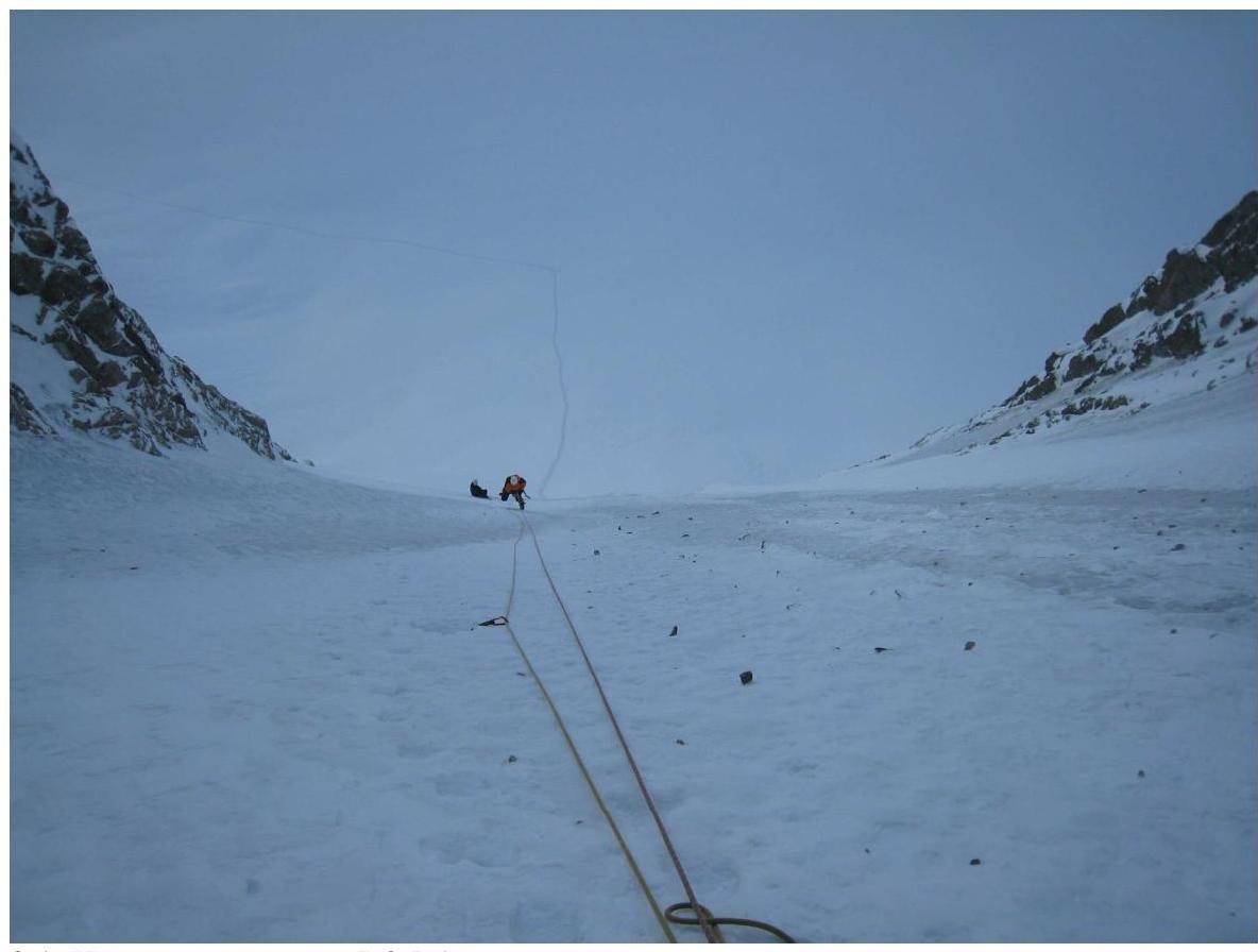 9.1. Start of the route, R0–R1.
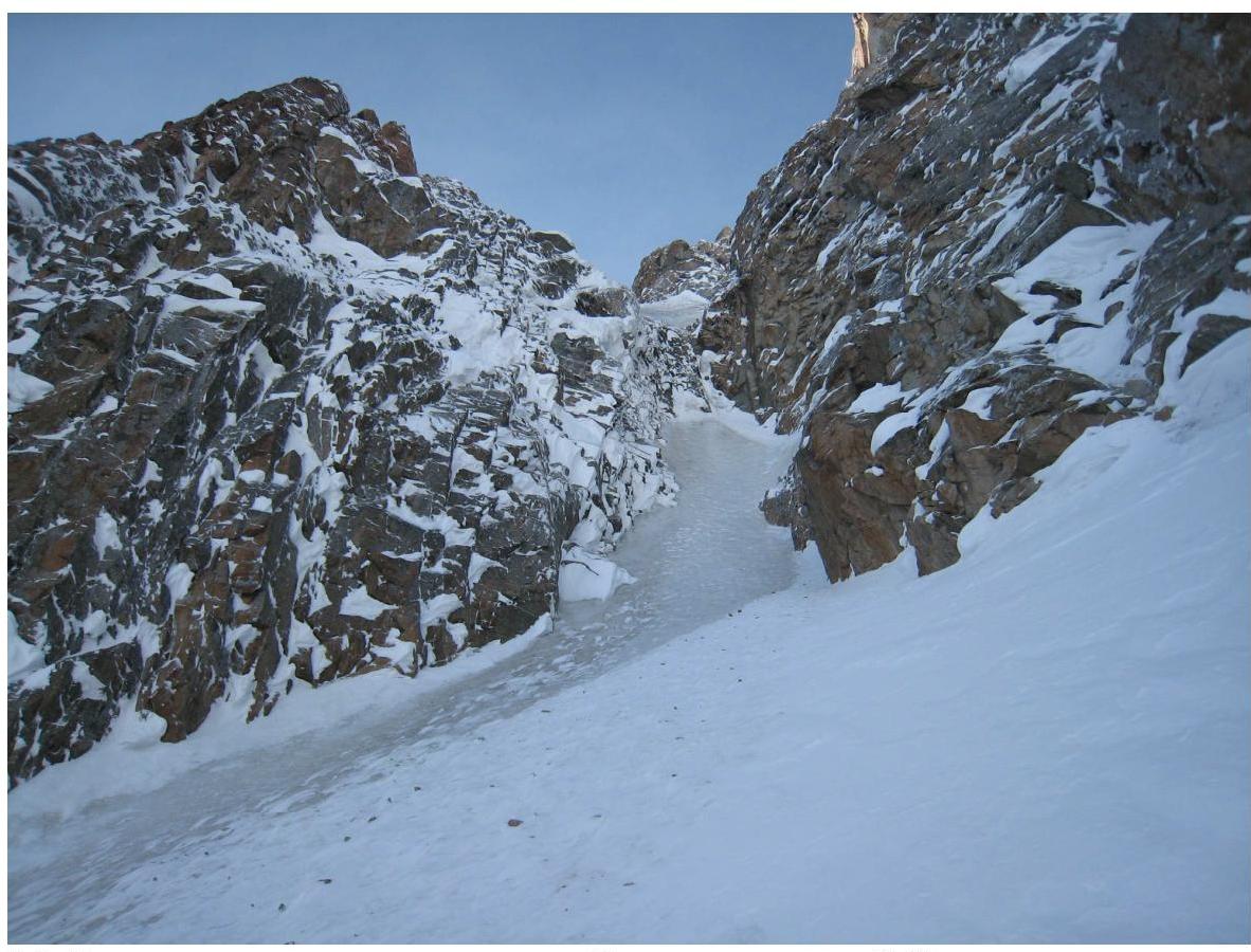 9.2. View of the first rock step. Appears straightforward but is actually a very serious section in winter.
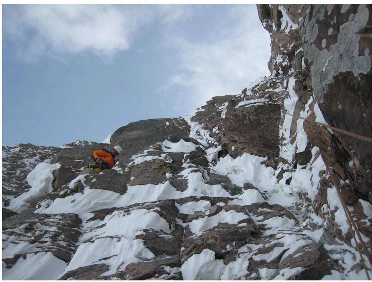 9.3. R5–R6. Passing the third rock step.
 9.4. View from R7 downwards.
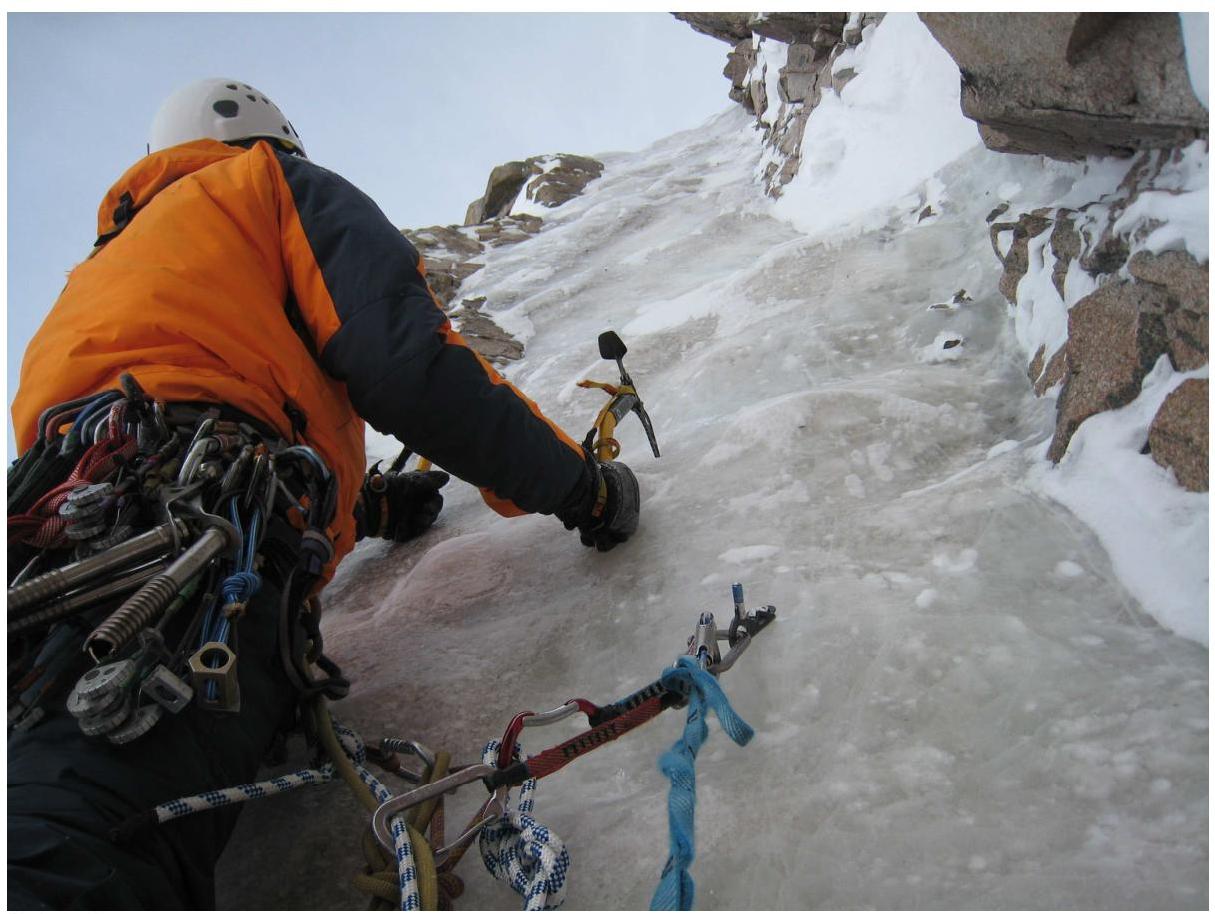 9.5. R8
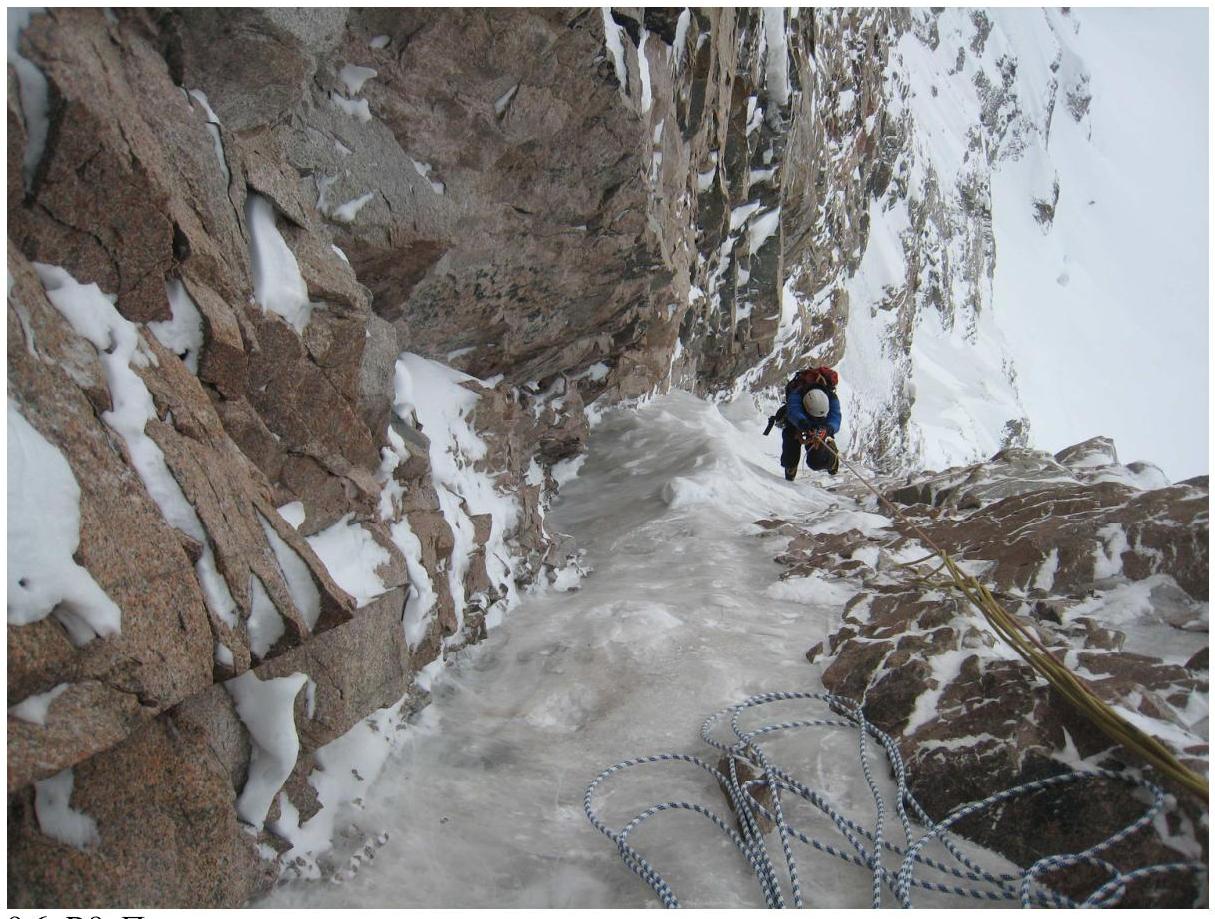 9.6. R8. Ascending via fixed ropes.