Passport
- Technical class.
- Tian-Shan, Kyrgyz range.
- p. Korona, 5th Tower, 4860 m, center of the NW wall.
- Proposed 6A category of difficulty, first ascent.
- Route characteristics:
- elevation gain — 650 m,
- length — 930 m,
- length of sections with 5–6 category of difficulty — 700 m,
- average steepness of the route — 67°,
- average steepness of the main part — 75°.
- Pitons driven:
| rock pitons | chocks |
|---|---|
| 74/27 | 107/5 |
-
Climbing hours – 26, days – 3.
-
Overnights: 1st — in a tent on a rock shelf, 2nd — in a tent on a shelf cut in the ice.
-
Team leader: Balyazin Valery Viktorovich, Master of Sports of International Class
Team members:
- Zakharov Nikolay Nikolayevich, Master of Sports of International Class
- Kokhanov Valery Petrovich, Master of Sports
- Obedin Konstantin Alexandrovich, Candidate for Master of Sports
- Savelyev Vyacheslav Anatolyevich, Master of Sports
-
Coach: Zakharov Nikolay Nikolayevich
-
Approach to the route: July 19, 1994. Summit: July 21, 1994. Return: July 21, 1994.
-
Team of Krasnoyarsk Regional Sports Committee.
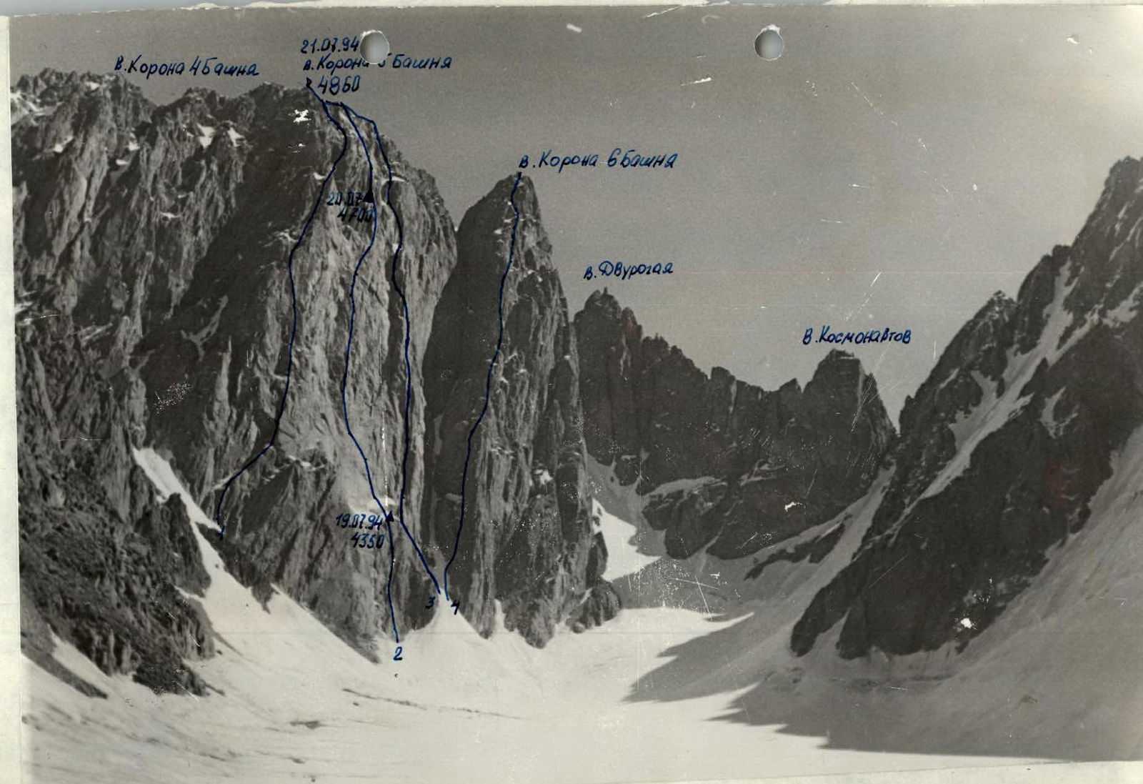
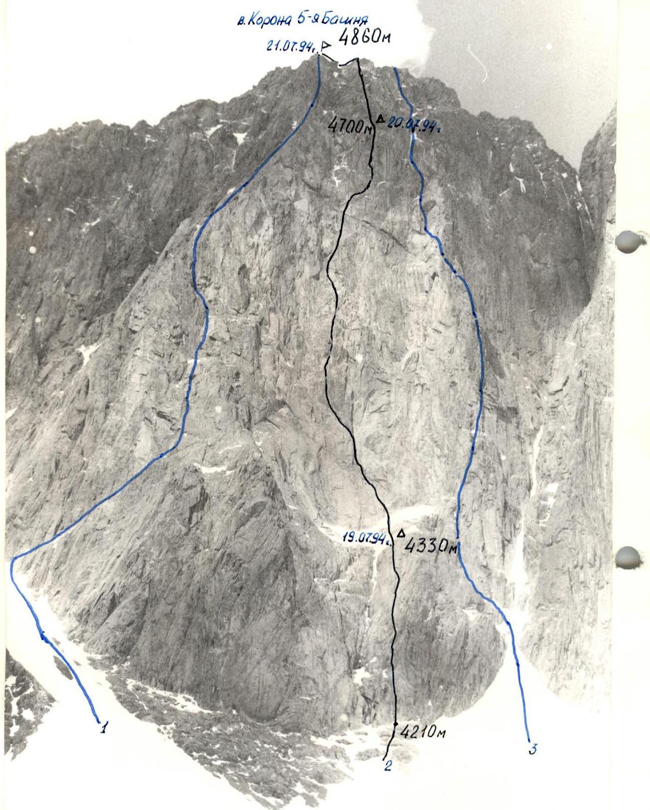 General photo of the route. Taken on July 18, 1994. Distance 1 km, height 4100 m. Camera "Praktica", F = 50 mm.
- 1 — Sadovsky route;
- 2 — route climbed by the team;
- 3 — Ruzh route. Shooting point #1.
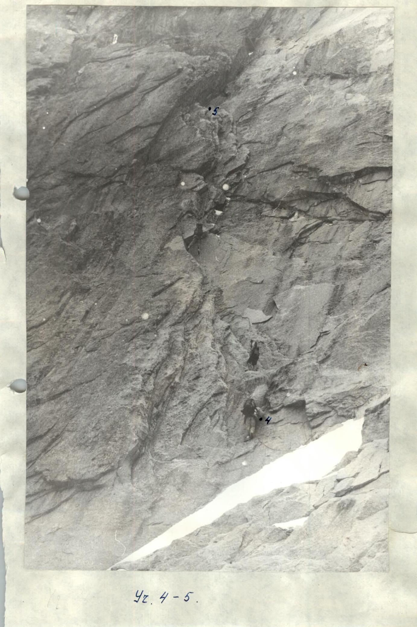
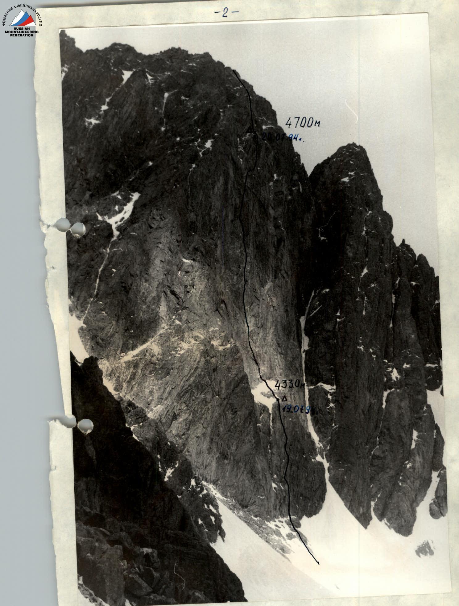 Photo of the route from the left. Taken on July 18, 1994. Distance 1 km, height 4300 m. Camera "Praktica", F = 50 mm.
Shooting point #2.
Photo of the route from the left. Taken on July 18, 1994. Distance 1 km, height 4300 m. Camera "Praktica", F = 50 mm.
Shooting point #2.
 Photopanorama of the area. Taken in June 1991.
- 1 — Sadovsky route;
- 2 — team's route;
- 5 — Ruzhevsky route;
- 4 — Glukhovtsev route.
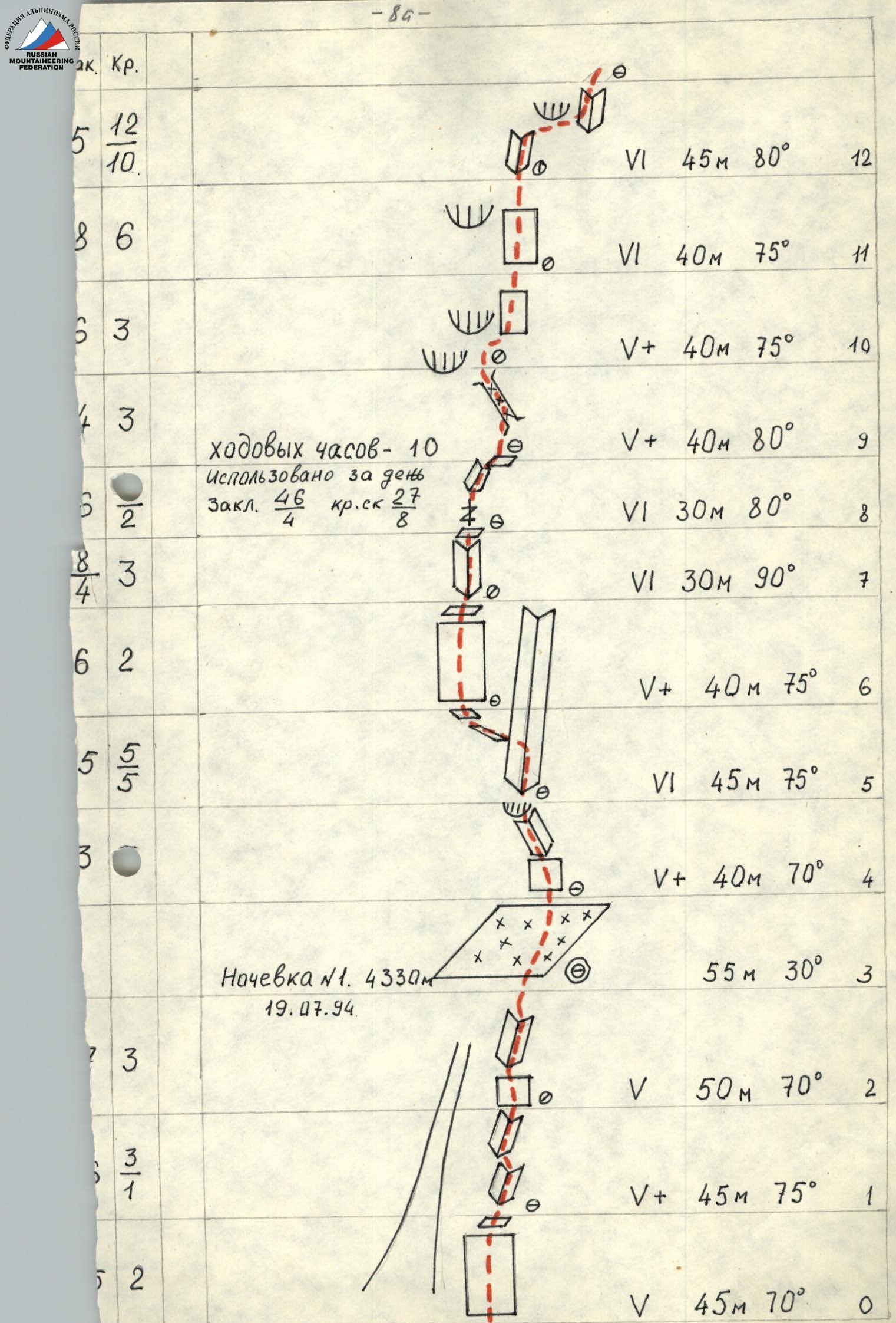
Tactical actions of the team
The team started the route according to the tactical plan on July 19, 1994, at 7:00. Having covered sections R0–R3 in 3 hours, the pair Balyazin–Obedin continued to process the route, while the other team members prepared a site for overnight stay. The tent was set up on the edge of a large snow-covered shelf under the cover of a rock wall. Overnight stay #1 at 4330 m. (Climbing hours for the day – 10. Used for the day: chocks – 46, rock pitons – 27).
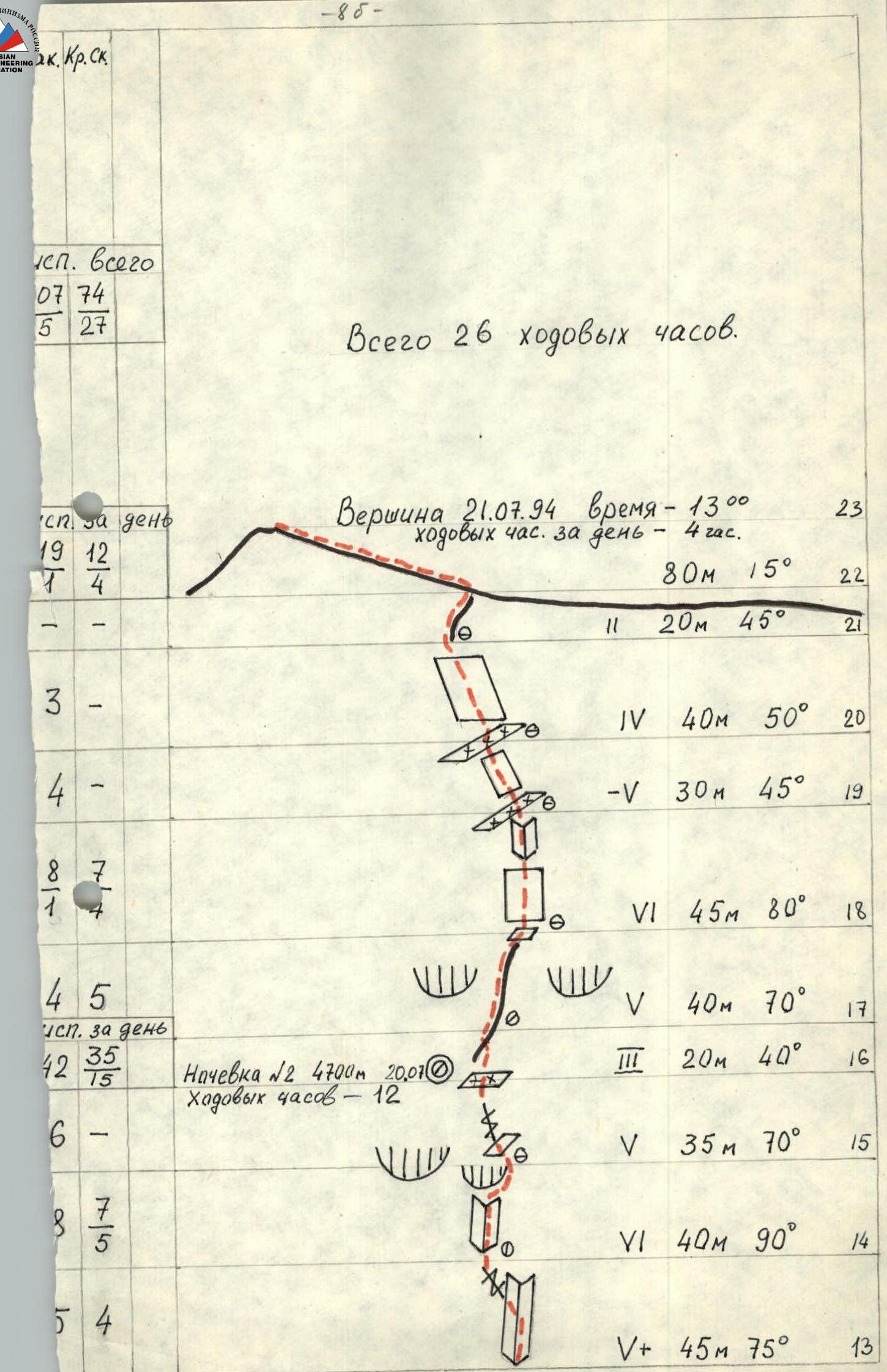
On July 20, they started moving at 8:00, with the pair Kokhanov–Zakharov leading. Challenging sections: R6–R7, R12–R13, R14–R15 — very difficult climbing, few cracks for belay organization, smooth terrain. The movement was complicated by snowfall that continued throughout the day. By 20:00, they reached the planned overnight stay location. The site for the tent was cut into the ice. Safe overnight stay. Overnight stay #2 at 4700 m. (Climbing hours for the day – 12).
On July 21, they started moving at 9:00. Savelyev–Obedin led. After bad weather, section R18–R19, which was a heavily iced and snow-covered rock wall, was problematic in terms of belay organization. Ice equipment was used. They reached the summit at 13:15. (Climbing hours for the day – 4).
Throughout the route, the first climber moved on a 2nd rope "Salewa", and upper belay was organized for the last climber. On sections R12–R13, R14–R15 with long traverses, upper belay was organized for all participants. All team equipment met UIAC safety standards.
The nutrition regime was as follows:
- hot breakfast in the morning before departure;
- daytime nutrition as needed from individual packages with hot drinks from thermoses;
- hot dinner in the evening.
The team was monitored by two people from a tent set up on the moraine under the route. The rescue team consisting of: Borzenko A. (head of rescue team), Gulyaev A., Kozyrenko E., Makachev V. — was located in Korona hut. Radio communication between observers and the team was carried out using a "Romashka" radio station according to the schedule: 8:00, 14:00, 18:00. Observation was carried out using binoculars. By agreement with the Kyrgyz Emergency Situations Ministry, long-range radio communication was established with Bishkek.
The route was completed without violating the tactical plan, with adherence to all safety measures, with a reserve of physical and moral strength.
Table of food products and fuel
| Product | Quantity | Weight (kg) |
|---|---|---|
| 1. Fried meat | 0.5 | |
| 2. Croutons | 1 | |
| 3. Lard | 1 | |
| 4. Tea | 0.1 | |
| 5. Sugar | 0.5 | |
| 6. Sprats | 3 cans | 0.8 |
| 7. Buckwheat groats | 0.5 | |
| 8. Condensed milk | 3 cans | 1.5 |
| 9. Dried vegetables | 0.5 | |
| 10. Walnuts | 0.4 | |
| 11. Dried fruits | 0.5 | |
| 12. Rice | 0.3 | |
| 13. Petrol | 1.5 | |
| Gas | 0.5 | |
| Total: | 9.6 |
The total weight of backpacks when approaching the route, including equipment, was 12.5 kg.
Description of the route by sections
- R0–R1 (45 m, 70°, cat. diff. 5). Rocky bastion. The route passes along a vaguely defined rib leading to the top of the bastion.
- R1–R2 (45 m, 75°, cat. diff. 5). Internal corners inclined to the right.
- R2–R3 (50 m, 70°, cat. diff. 5). Internal corner inclined to the right, then a smooth wall leading to a large snow-covered shelf. Overnight stay on the shelf.
- R3–R4 (55 m, 30°). Snow-covered shelf.
- R4–R5 (40 m, 70°, cat. diff. 5). Monolithic smooth wall with small internal corners inclined to the left. Along the corners to the base of a huge vertical internal corner.
- R5–R6 (45 m, 75°, cat. diff. 6). Up the vertical corner, then a traverse to the left onto a small inclined ledge and along it to the left.
- R6–R7 (40 m, 75°, cat. diff. 5). Monolithic smooth wall. Problems with organizing belay points. Exit onto an inclined ledge under a steep internal corner.
- R7–R8 (30 m, 90°, cat. diff. 6). Vertical internal corner leading to a rocky outcrop where an overnight stay can be organized if necessary.
- R8–R9 (30 m, 80°, cat. diff. 6). Vertical wide crack, then an internal corner, followed by an exit onto a ledge.
- R9–R10 (40 m, 80°, cat. diff. 5). From the ledge upwards, a steep monolithic wall, then an inclined chimney filled with ice, abutting a cornice.
- R10–R11 (40 m, 75°, cat. diff. 5). The cornice is bypassed on the right along a steep monolithic wall by free climbing.
- R11–R12 (40 m, 75°, cat. diff. 6). Smooth monolithic wall.
- R12–R13 (45 m, 80°, cat. diff. 6). Internal corner with a thin crack, then a traverse to the right along the wall to exit into an internal corner and along it onto a ledge. Problems with organizing belay.
- R13–R14 (45 m, 75°, cat. diff. 5). Internal corner, then a traverse to the left onto a steep wall.
- R14–R15 (40 m, 90°, cat. diff. 6). Vertical internal corner abutting a cornice, which is traversed from left to right to exit onto a sloping ledge.
- R15–R16 (35 m, 70°, cat. diff. 5). From the ledge to the right along a steep crack, then a chimney filled with ice, and further along the slabs — exit onto a snow-covered ledge. On the ledge, an overnight stay in a tent on a platform cut into the ice.
- R16–R17 (20 m, 40°, cat. diff. 3). Snowy ridge.
- R17–R18 (40 m, 70°, cat. diff. 5). Rocky rib ending in a ledge in the middle of a rocky "well".
- R18–R19 (45 m, 80°, cat. diff. 6). Wall of the rocky "well", partially heavily iced. Exit onto a snow-covered ledge.
- R19–R20 (30 m, 45°, cat. diff. 5). Gentle snow-covered slabs.
- R20–R21 (40 m, 50°, cat. diff. 4). Rocky slope, partially snow-covered.
- R21–R22 (20 m, 45°). Rocky ridge leading to the main pre-summit ridge.
- R22–R23 (80 m, 15°). Along the snowy ridge to the summit.