Ascent Plan
The ascent of Peak Sovetsky Kyrgyzstan from the south along the ridge between the Ozarovsky and Pastukhov glaciers was conducted as part of the overall plan of the LOS DSO "TRUD" team, which participated in the 1962 USSR championship in the traverse class (Alamedin Wall).
The ascent to Peak Sovetsky Kyrgyzstan (4840 m) via the specified route was done for the first time, and a first ascent was made to the West Kyrgyzstan peak (4820 m).
According to the plan for reconnaissance and training ascents, two groups:
- Slyozin Yu.B. — Master of Sports
- Shevchenko Yu.S. — 1st category
as well as
- Ivanova T.G. — 1st category
- Yagotints V.D. — 2nd category
were to reach the Ozarovsky South glacier cirque, inspect part of the Alamedin Wall traverse, and ascend Peak Sovetsky Kyrgyzstan from the south. Depending on the complexity and length of the route, as well as the participants' well-being, the ascent was to be made either separately with a corresponding interval or simultaneously by the entire foursome under Slyozin's leadership.
The ascent was started by the foursome, but due to the route's significant complexity, it was completed only by the Slyozin-Shevchenko pair, observed by the Ivanova-Yagotints pair.
The Slyozin-Shevchenko pair, part of the core team of LOS DSO "TRUD", was well-acquainted from previous joint ascents. In the 1961 season, they ascended Shkhara's northern edge. As part of the team, they intensively trained according to a special plan for the Alamedin Wall traverse. Before this ascent in the 1962 season, they conducted several reconnaissance climbs to the Corona towers (Alarchinsky area) and the Alamedin region.
General Characteristics of the Route
The route is overall combined. For the convenience of description, it can be divided into the following sections, which differ sharply in the nature of the path:
- Section 1
- Section 2
- Section 3
I. Exit to the ridge from the Ozarovsky glacier. A snowy slope turning into ice. The steepness gradually increases, reaching 50° before exiting onto rocks. Further — ice-covered, partially snow-covered rocks until the ridge is reached. Ice is covered with 5–15 cm of snow but is exposed before rocks (two ropes). Insurance — only the first six ropes via ice axe; the rest of the slope is traversed with piton insurance. Rocks are crumbling, snow-covered, with some névé ice, steepness 50–60°, traversed with piton insurance. Reaching the ridge takes a whole working day (8 hours). There are places for overnight stays on the ridge.
II. Ridge ascent to the exit below West Kyrgyzstan.
A purely rocky ridge. Average steepness 45° with individual sections of greater steepness. Insurance is via pitons and rock outcrops. Mainly rocks of medium difficulty, with some very difficult sections. Steep ascents (walls) are either traversed directly or bypassed on the right. The pair spent 5 hours on this section. At the end of the section, before reaching the two gendarmes below the West Kyrgyzstan peak, the snowy ridge has two enormous cornices towards the Ozarovsky glacier (four ropes).
III. Ascent to the West and then the Main peak of Sovetsky Kyrgyzstan.
A wide ridge with huge cornices throughout the section. Cornices are directed towards the Salyk glacier ("to the left of the direction").
Upon reaching the West peak — several ropes of severely crumbling rocks; the path follows the boundary between snow and rocks; cornices are bypassed with careful insurance.
IV. Descent route.
Descent follows the ascent route until the ridge is reached. Further descent does not coincide with the ascent and goes along the rocky ridge with dips, through several gentle gendarmes; rocks are difficult in places, with several sports descents and rappels. Insurance is via rock outcrops and pitons.
Descent from the ridge via a wide "reddish" couloir onto the Pastukhov glacier and further along the glacier and moraines to the trail.
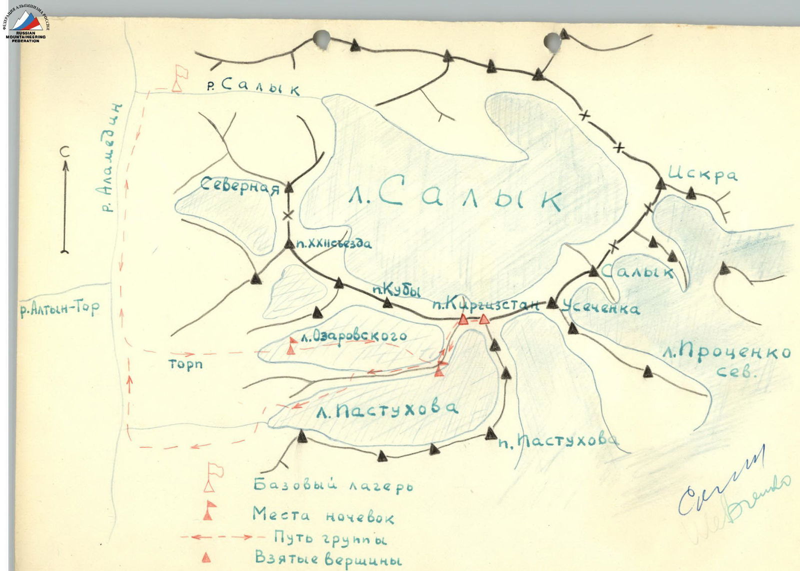
Description of the Ascent Area
Peak Sovetsky Kyrgyzstan is located in the central part of the Kyrgyz Ala-Too range within the Alamedin Wall massif. It is the third highest peak in the Kyrgyz Ala-Too (4840 m), уступая his highest point — Peak Semeynov-Tyanshansky — by only 35 m.
The Alamedin valley is relatively accessible:
- From Frunze — an automobile road (about 30 km), ending slightly above the so-called "Wolf Gates".
- Further — 18–20 km along a livestock trail along the right (orographic) bank of the Alamedin river to the confluence of the right tributary — the Salyk river, where alpine base camps are usually located for ascents in the Alamedin Wall area.
The slopes of the valley are treeless. Higher up the valley — thickets of bushes, and only in places small groves of thuja, birch, and rowan. Side valleys are intensively used as summer pastures.
The snow line is located high, around 4000 m. The tongues of large glaciers descend below 3500 m. With extremely insignificant lateral moraines, the terminal moraines are impressively developed. As a rule, glaciers are "armored" with debris material (especially the Salyk glacier). Glaciers are significantly retreating.
In mountaineering terms, the area is insufficiently developed:
- Several peaks remain unconquered.
- Interesting wall routes on Peak Sovetsky Kyrgyzstan, Usechanka, and others from the north remain untried.
- There are many unattempted technically difficult ridge routes and traverses.
Ascent Description
Day 1. The group of four departs from the base camp located at the confluence of the Salyk and Alamedin rivers at 6:30 AM. The path lies up the Alamedin valley along a trail with a slight ascent. By 10:00, we reach the left tributary (orographic) — the Altyn-Tor river. Above the confluence of the Altyn-Tor river, the Alamedin valley rises in a steep step of 150 m. We ascend the step and turn left onto a steep grassy slope "torp", representing an ancient terminal moraine of the Ozarovsky glacier. Over 600–800 m in height, the slope has a uniform steepness of about 30°, then the steepness decreases, and the ascent proceeds along chaotic moraine ridges, initially overgrown with grasses and then bare. The ascent up the "torp" took 2 hours and 30 minutes. The gentle moraine ridges to the tongue of the Ozarovsky glacier — the southern one — took another 3 hours. A hundred meters from the debris-free surface of the glacier, an overnight stay was organized. The weather deteriorated by mid-day: rain turned to wet snow.
Day 2. The weather is good in the morning. We build a cairn. We inspect the surrounding cirque peaks. A fairly long rocky ridge leads to Peak Sov. Kyrgyzstan. The exit to the ridge was not fully visible but seemed relatively uncomplicated. The southern steep walls ended to the left with a nameless peak over 4600 m with an absolutely smooth, sheer wall of 800–900 m. During the traverse of the Alamedin Wall by the Kheysin group, the nameless peak was named — by right of first ascenders — Heroic Cuba. We departed from the overnight site at 6:35 AM. We move up the glacier for 40 minutes. Reaching its upper reaches, we turn right and begin ascending the ridge, aiming to the right of the ice fall. We rope up. After 3–4 ropes, we start moving in turns, with ice axe belay. Higher up, the snow becomes even softer, steps don't hold well, and we have to tread carefully. Further on, the snow layer is 15 cm; we put on crampons, though with such snow thickness, we have to dig down to the ice. Insurance is via pitons: initially every 30 m, but the last three ropes before exiting onto rocks are more frequent — every 15–20 m. A total of 9 ice screws are hammered. The ascent to the lower rocks took 5 hours and 30 minutes.
The path through the rocks initially goes left and up (diagonally), then more to the right, following a not very pronounced ridge. Rocks are heavily crumbled, snow-covered, and sometimes icy. Steepness is around 50–60°. To the ridge, there are 4–5 ropes. Insurance is via pitons and rock outcrops. 7 pitons are hammered. Traversing the rocky section took 2 hours and 40 minutes. Descending 15 m from the ridge towards the Pastukhov glacier, we make a platform on a ledge and spend the night. A control cairn and a note are left.
Day 3. Upon inspecting the rocky ascent, the route proved significantly more complicated than anticipated. Given that there were only two and a half days left until the control deadline, it was decided that the stronger Slyozin-Shevchenko pair would attempt to complete the ascent or, at the very least, inspect the closed part of the main ridge of the massif and leave a cache. The second pair remained at the overnight site, observing. The pair departed on the route at 6:40 AM; the weather was good. Initially, the path follows a horizontal section of the ridge about 100 m long. On this section, there are three gendarmes: two about 4–5 m and the last about 30 m high. The smaller gendarmes overhang to the south, towards the Pastukhov glacier, and face the Ozarovsky glacier with smooth slabs at 60°, where a thin 5–10 cm layer of snow begins 3 meters from the ridge. The gendarmes drop sheerly along the path, so the only way is to bypass them along the slabs with micro-ledges and careful piton insurance. 4 pitons are hammered. The large gendarme drops with negative walls both to the south and north. Passing it is one of the most challenging parts of the route. To the right (along the path) of the gendarme, about 1–1.5 m of the massif has broken off, forming a crevice. The path goes along the ridge, then up the wall into the crevice. Further, there's a descent via an internal corner (6–8 m). Between the main and broken-off parts of the gendarme, and a traverse under overhanging rocks — 4 m (very difficult spot!). Then the path follows a steep couloir for 6 m. Bypassing the large gendarme took the pair 40 minutes. 4 pitons are hammered, and a ladder is hung.
The first ascent of the ridge is traversed somewhat to the left, initially along a wall (steepness not less than 65° but with good handholds) — one rope, further — along a groove with patches of snow. Climbing is of medium difficulty but requires attentiveness due to the abundance of "live" stones. The groove — four ropes. Insurance is via rock outcrops and pitons. The ridge is initially wide but with slab-like "sides," gradually narrowing. The last rope is traversed along a sharp rocky ridge, leading to a sloping snow-covered ledge, above which a nearly sheer 20-meter smooth wall rises. The wall is bypassed on the right: first, a traverse to the right along a snowy ledge — 5 m, then an ascent to the right and up via a crevice — 5 m, a descent via an internal corner — 8 m, a traverse into a couloir — 3 m, and an ascent up a narrow couloir to the ridge — 40 m. The couloir contains many "live" stones, partially held together by ice. In its upper third, it's sensible to exit onto the wall (to the right along the path). Insurance during ascent and descent via the internal corner is via rock outcrops; during the traverse and in the couloir — via pitons (5 pitons).
The couloir leads back onto the ridge. After a rope and a half of medium-difficulty ridge, there's a wide ledge with scree, followed by a monolithic sheer wall 15–18 m high. The wall is only partially bypassed. We move right under the wall for 6–8 m, then up 3 m of very difficult climbing, further — a path of medium difficulty with good handholds — to the ridge 60–70 m. 3 pitons are hammered. Further on, the ridge is of medium steepness, 45°.
Rocks are solid, reliable, and pleasant, though quite difficult to climb. Insurance is mainly via rock outcrops. For five ropes, the pair hammered 2 pitons. After the scree ledge, there's another wall of 8–9 m. It's traversed directly, with 2 pitons hammered. After that, there are crumbling rocks, with gentle sections of 15–20° alternating with small walls of 3–6 m, requiring careful insurance and strenuous climbing. Very complex, handhold-less ascents along the ridge can usually be bypassed on the left.
The last gendarme (before reaching the snowy ridge leading to the gendarmes before the West peak) is bypassed along small ledges on the right (three ropes). Insurance is via rock outcrops.
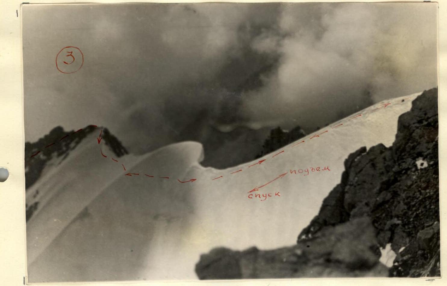
The snowy ridge (160–180 m) with two enormous cornices is traversed with careful insurance below the base of the cornice. Snow is deep, above the knee, soft, and step-kicking is required.
We reach the two gendarmes (13–15 m) of the main ridge of the Alamedin Wall. Here, in a depression under the gendarmes, there are excellent overnight stays.
- We build a cairn
- Leave a note
- Leave a cache for the traverse
Traversing the rocky ridge took the pair 5 hours.
The further path through the West peak to the Main peak of Sov. Kyrgyzstan generally doesn't present significant technical difficulties: an ascent along crumbling rocks with a steepness of 35–40° with turn-by-turn insurance on the shoulder and then to the West peak (40 m). We build a cairn. A note from the first ascenders is left. From the West peak to the Main peak, there's a wavy, wide ridge with enormous cornices towards the Salyk glacier. The path follows the boundary between snow and rocks. From the West peak, we descend along crumbling rocks (25 m), then there's a snowy-icy section — 12 m (5 steps are cut). Before reaching the Main peak, there's a gentle ascent along crumbling rocks (two ropes); the path from the West to the Main peak takes 30 minutes. The peak is a huge snowy dome. Despite thorough searching, the cairn and note from the first ascenders (the Marechek group) were not found. Later, the Milovanovich group (which repeated our route) and the Kheysin group, which traversed the Alamedin Wall massif, also failed to find Marechek's note. A cairn with a note is built by us on the rocks on the southern side where the ridge branches off towards Peak Pastukhov. Descent follows the ascent route to the overnight site of the observing pair — 6 hours.
Day 4. During the ascent to Peak Sov. Kyrgyzstan, an alternative descent route was inspected along the ridge between the Ozarovsky and Pastukhov glaciers down to the depression occupied by a firn field with a very noticeable snowy lake. From here, a wide "reddish" couloir led onto the Pastukhov glacier.
The group departs at 8:20 AM. Ascending 15 m from the overnight site to the ridge, we descend to the depression before the next gendarme (three ropes). Then 5–6 ropes are traversed in bypassing the gendarme (to the left along the path) along very large rocky blocks. Two sports descents of 30 m each lead to a snowy depression located to the right of the rocky ridge. After re-emerging onto the ridge, the path becomes more complicated (five ropes). We traverse a series of small dips in the ridge (2–7 m). Insurance is via rock outcrops and pitons. Small gendarmes encountered are bypassed on the left or directly in front.
The path is difficult. Rocks facing the Ozarovsky glacier are monolithic and quite steep, 50–70°. Descent down the last wall is via rappel onto the snow of the firn field. From here, an easy path follows the small scree of the "reddish" couloir onto the Pastukhov glacier. The section from the overnight site to the Pastukhov glacier is traversed in 4 hours.
The Pastukhov glacier, unlike other glaciers in the area, is heavily crevassed. Numerous crevices traverse the entire surface. In the lower part, there's a difficult but relatively short icefall. Lateral moraines are very weakly expressed. We traverse:
- Initially along the right (orographic) edge of the glacier, covered with remnants of snowy fields,
- then between the glacier and the lateral moraine.
The path is dangerous due to overhanging seracs (15 minutes of walking). Further along the moraine, we bypass the tongue of the glacier and cross to the left-bank moraine, down which we descend to the livestock trail. The specified section of the path is traversed in 2 hours.
Further along the trail — to the Altyn-Tor valley and along the right (orographic) bank of the Alamedin river to the base camp (3.5 hours).
Based on a comparison with other routes we've taken, the ascent is rated as 5A category of difficulty.
9 ice and 36 rock pitons were hammered. The repeat ascent by the LOS DSO "TRUD" group under the leadership of Milovanovich (1st category) confirms the route's difficulty as 5A category.
We provide the time breakdown for the Milovanovich group (4 people):
- Day 1. — Standard approach to the Ozarovsky glacier.
- Day 2. — Exit to the ridge. 8 hours.
- Day 3. — Ascent to the Main peak of Sov. Kyrgyzstan and descent to the West peak — 11 hours.
- Day 4. — From the West peak, descent to the overnight stay on the firn field by the snowy lake — 9.5 hours.
- Day 5. — Descent to the Pastukhov glacier, along the moraine, and further along the trail back to the camp.
The description was compiled by: Slyozin Yu.B., Shevchenko Yu.S.
 www.alp-federation.ru
www.alp-federation.ru
www.alp-federation.ru
