Passport
- Winter category
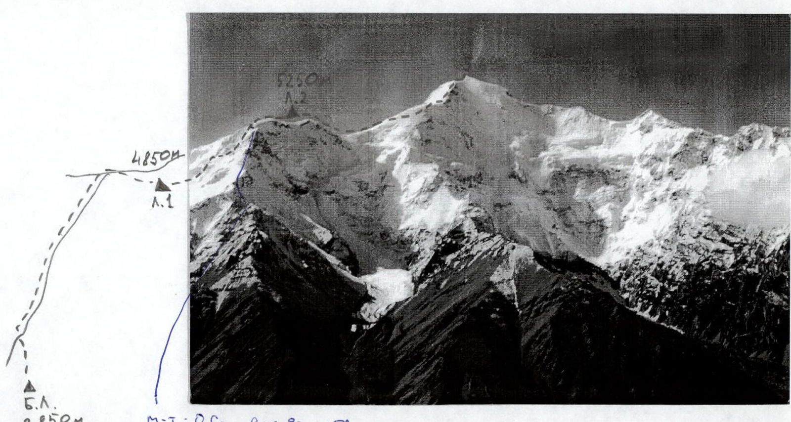
- Central Tien-Shan, Engilchek valley
- Peak Nansen via Northeast ridge
- Proposed 5B category of complexity, first ascent
- Height difference 2847 m, length 3130 m, average steepness of the main part of the route 30.5°
- No hooks were left on the route. No previously driven hooks were found
- Team's climbing hours: 23 hours to the summit. Total 37 hours. Days - 4.
- Nights spent - 4 in tents.
- Leader: Manulik Alexander Gennadyevich, Candidate Master of Sports. Participants: Mikhailov Mikhail Mikhailovich, Master of Sports, Puchinin Andrey Albertovich, Candidate Master of Sports, Akimov Vitaly Vladimirovich, 1st sports category
- Coach: Biryukov Vladimir Nikolaevich, Kyrgyz Republic
- Departure to the route - January 28, 1997. Return - February 1, 1997.
- Organization - Federation of Alpinism and Rock Climbing of the Kyrgyz Republic.
Preparation for the Ascent
Reconnaissance of the object and ascent route was conducted in August-September 1996 by the ascent leader Manulik A.G. The object of the training ascent was the peak Bececek in the Ala-Archa alpine camp area via the B. Kuzmenko route - SW buttress, 5A category of complexity. The ascent was made on December 23, 1996, by the entire team. Additionally, on November 16, 1996, a double-team ascent was made to the same peak via the ice couloir of the western wall, 5A category of complexity. From literary sources, as well as from the personal experience of the team's coach and participants, the ice and snow conditions in winter were known - a slight snow cover on both southern and northern slopes of the Inelchek ridge. The snow cover was expected to start at an altitude of 4500 m and have a depth of 20-40 cm. It was planned to make the first night stop (camp 1) approximately at this height, at 4850 m. It was assumed that the key section of the route would be the icefall with a height difference of 4850-5250 m. This section was expected to have ice walls with a steepness of up to 80°. For this section, a pair of ice axes was taken. It was planned to make the second night stop (camp 2) after this section. From this camp, it was decided to make a summit push and then make the third night stop in the same camp. From camp 2 to the summit, an ice-firn ridge was visible from below. The plan was to overcome it with simultaneous belay in doubles. When choosing equipment, it was taken into account that the air temperature in this area in January could drop to -40°C and lower. Both night stops were planned to be on ridge sections, which ruled out avalanche danger and rockfall danger. A high-altitude, double-layered, two-slope tent was chosen for the ascent; each participant had a sleeping bag and a down jacket, and two sets of double-layered gloves. Three days of training at an altitude of over 3000 m allowed the entire team to acclimatize well. Communication with the base camp was provided using VHF radios of the "Olinko" type. Communication between the base camp and the Mayda-Adyr base was carried out using HF radios of the "Angara" type. To implement safety measures, a group of observers consisting of 4 people and a rescue team of 8 people were stationed at the base camp.
Tactical Actions of the Team
The tactical plan was fully implemented by the team without deviations. The section of the route from the base camp to camp 1 was traversed without any belay. The section of the route from camp 1 to camp 2 was traversed with the organization of belays. Stations were set up on ice screws. The passage of ice walls was done using ice axes. The team captain, Manulik A.G., worked first on this section. The section of the route from camp 2 to the summit and back was traversed by two rope teams with simultaneous belay. First rope team: Manulik A.G., Mikhailov M.M. Second rope team: Puchinin A.A., Akimov V.V. The section of the route from camp 2 to camp 1 was traversed with the organization of belays on ice screws, followed by their removal using a self-releasing device. Night stops were located on ridge sections of the route, ensuring safety from avalanches and rockfalls. Food: per participant per day: 200 g of chocolate, 100 g of freeze-dried soup, 10 g of tea, 70 g of lard, 50 g of sugar, 300 g of bread, 20 g of dry milk, 100 g of dry vermicelli. Dried apricots and raisins were used as pocket food. Fuel on the route was consumed at a rate of 1 gas cylinder (1400 g) per day. The total weight of food and fuel for the entire team per day was 4800 g. Hot meals were prepared twice a day. During the ascent, a rescue team with the right to exit on a 5B category route was stationed at the base camp. The route was left clean, all ice screws were removed. There were no falls or injuries on the route.
| R0 | R1 | R2 | R3 | R4 | R5 | R6 | R7 | R8 | R9 | R10 | R11 | R12 | R13 | R14 | R15 | avg. steep. |
|---|---|---|---|---|---|---|---|---|---|---|---|---|---|---|---|---|
| ∠° | 15° | 12° | 15° | 40° | 15° | 60° | 15° | 40° | 10° | 40° | 30° | 35° | 40° | 15° | 45° | 30.5° |
| dist | 1300 m | 400 m | 70 m | 20 m | 60 m | 300 m | 60 m | 50 m | 200 m | 120 m | 150 m | 100 m | 150 m | 50 m | 100 m | 3130 m |
| cat. | 1 | 2 | 2 | 4 | 2 | 5 | 2 | 4 | 2 | 4 | 3 | 4 | 4 | 3 | 5 |
Description of the Route by Sections
The section of the route from the base camp (B.C.) to camp 1 (C.1) - R0-R2 was traversed along a safe ridge without belay. Section R2 - a simple snow ridge. Section R3 - ice wall 40°. Traversed with belay organization. The team captain, Manulik A.G., worked first. All snow-ice sections were traversed using ice axes. Section R4 - a simple snow ridge. Simultaneous belay. Section R5 - ice wall 300 m, steepness 40-75°. Belay organization. Manulik A.G. worked first. Section R6 - snow-firn knife edge. Simultaneous belay. Section R7 - snow-firn wall 40°. Simultaneous belay. Section R8 - snow-firn plateau. Simultaneous belay. A safe location for a night stop (C.2). Section R9 - ice wall 40°. Traversed with belay organization and removal of ice screws using a self-releasing device. Section R10 - a simple ice-snow ridge. Simultaneous belay. Section R11 - a fairly steep (40°) firn slope. Simultaneous belay. Section R12 - ice-firn wall 40°. Traversed with simultaneous belay. Section R13 - ice-firn knife edge. Simultaneous belay. Section R14 - ice-firn wall. Traversed with simultaneous belay.