
Ch. Valikhanov
The peak "Bezymyannaya" (4200 m) is located in a lateral ridge branching off the main ridge of Trans-Ili Alatau between the peaks Suleiman Stalsky and OPTЭ, to the northeast towards Lake Shokalsky. The northern slopes of the peak are icy with rocky outcrops, while the southern slopes are steep rocky walls and counterforts separated by couloirs (photo #1).
The approach to the peak from the "Talgar" camp goes as far as the green glade below Lake Kroshka and further along the moraine of Lake Shokalsky; we approach the beginning of the ridge where a night's stay is organized.
Approach time: 4–5 hours.
Description of the ascent route
The ascent path goes to the northeastern ridge. The exit to the ridge is made along the third couloir descending from the northern slope, in the direction of a characteristic rocky finger resembling the head of the idol Aku-Aku from Easter Island described by Thor Heyerdahl.
The lower part of the couloir:
- snowy
- wide
The upper part of the couloir:
- broken rocks
- medium difficulty
The length of the path to the exit on the ridge: 130–150 m.
Features of the path along the ridge:
- crumbling rocks
- need for exceptional attention
After exiting onto the main route, the first 30 m of the path goes straight along the ridge with insurance through rocky outcrops, then follows a transition to the left onto shelves. Initially not very difficult, they gradually turn into narrow, broken terraces going up to the right, running up to the foot of the first large "gendarme".
The first "gendarme":
- Ascended directly via steep walls and an internal angle
- Insurance - through rock pitons
- Climbing height - 120–130 m
- Required number of pitons - 10–11
The saddle between the first and second "gendarme" is snowy and wide (photo #3). A good night's stay can be organized here.
The path to the base of the second "gendarme" goes along a snowy ridge, initially steeply upwards, then taking a horizontal direction.
The path to the second "gendarme" initially goes to the left for the length of one rope, then sharply turns to the right along an internal angle, by which we exit onto the ridge. Hammering in a rock piton, we move along the ridge and move to the right onto a wall, traversing which after 40–50 m we reach the saddle to the base of the third "gendarme". Here, a rock piton is hammered into a slab, and a descent begins below the saddle to a wide crevice. Along the crevice, hammering in two pitons, we exit to a "cork" between the third and fourth "gendarme".
Having exited onto the "cork", we find ourselves at the fourth "gendarme" - the "ridge". This is a steep ridge, so sharp that one can only move along it by sitting astride (photo #4). On both sides, it drops away with sheer walls 300–400 m deep, and movement along it is therefore complicated by the possibility of losing balance.
Having overcome the "ridge", we descend onto a small area to the left, hanging over the abyss of the southern slope. Here, on the site, the second control cairn is built. The first control cairn is located on top of the first "gendarme". From the site, having moved 4 m forward along a shelf, we descend 3–4 m down and traverse to a sharp rocky finger on the ridge. The finger is circumvented from the right side.
For insurance on this section, three pitons are required.
The further path goes along slabs on which there are many loose rocks. The slabs turn into a rocky ridge, gradually turning into a wall. We overcome it with piton insurance and approach the ridge leading to the fifth "gendarme". The ridge is narrow, broken by frequent gaps, requiring attentive insurance.
The fifth "gendarme" is a steep black slab 30 m high. The ascent is made to the left upwards. The danger is exacerbated by the fact that the wall overhangs the southern slope and has a negative slope underneath, so that in case of a fall, a climber hangs on a piton in the air. Therefore, to ensure safety, it is required to hammer in at least 4 rock pitons.
Along a simple ridge, we approach the base of the sixth "gendarme". It is overcome on the right along the wall (photo #5). Here, we leave a rope loop and descend the full length of the rope by rappel onto a saddle. The saddle is wide; there, under the base of the rock, is a small lake.
The further path goes along a steep snowy slope, and then along a snowy comb to the next group of "gendarme". The snowy slope is avalanche-prone, so it is necessary to exit onto the comb strictly vertically, without deviating to the right or left onto the lateral slopes of the peak.
The path from the exit onto the ridge under the base of the seventh "gendarme" takes 8–10 hours of difficult work. The great psychological load when working on large sheer sections greatly exhausts the nervous system. Therefore, a night's stay is not recommended here on the flat part of the snowy ridge.
The seventh and eighth "gendarme" are passed on the left along medium rocks.
Along the ridge, we approach the ninth "gendarme", which is overcome directly via a rocky wall with piton insurance.
A long narrow ridge with a slight dip leads to the tenth "gendarme".
The tenth "gendarme" hangs over the saddle with an enormous rocky cornice. This cornice also forms an overhang above the slopes of the ridge.
A detour to the left is impossible: vertical rocky walls without shelves drop away 200 m down.
To the right, a narrow terrace goes under the rocky cornice. The terrace is covered with glazed frost. Scraping footholds with an ice axe, we crawl along the terrace for 18–20 m (photo #6).
Here, 3 rock pitons are hammered in. Then the cornice ends, and it is possible to exit by cutting steps in the ice with insurance through two ice pitons to the left along the icy slope forming the pedestal of the "gendarme".
Fifteen meters of path bring us to a rocky area located on the wall of the "gendarme". Further to the left, an icy couloir goes, turning into a rocky wall in its upper part. Water flows from the wall. To overcome the couloir, it is required:
- two ice pitons
- three rock pitons
Along the couloir, we exit onto a saddle between the tenth and eleventh "gendarme". On top of the tenth "gendarme", a control cairn is built.
The eleventh "gendarme" - an unclearly pronounced rise of the ridge - is passed from above along easy rocks.
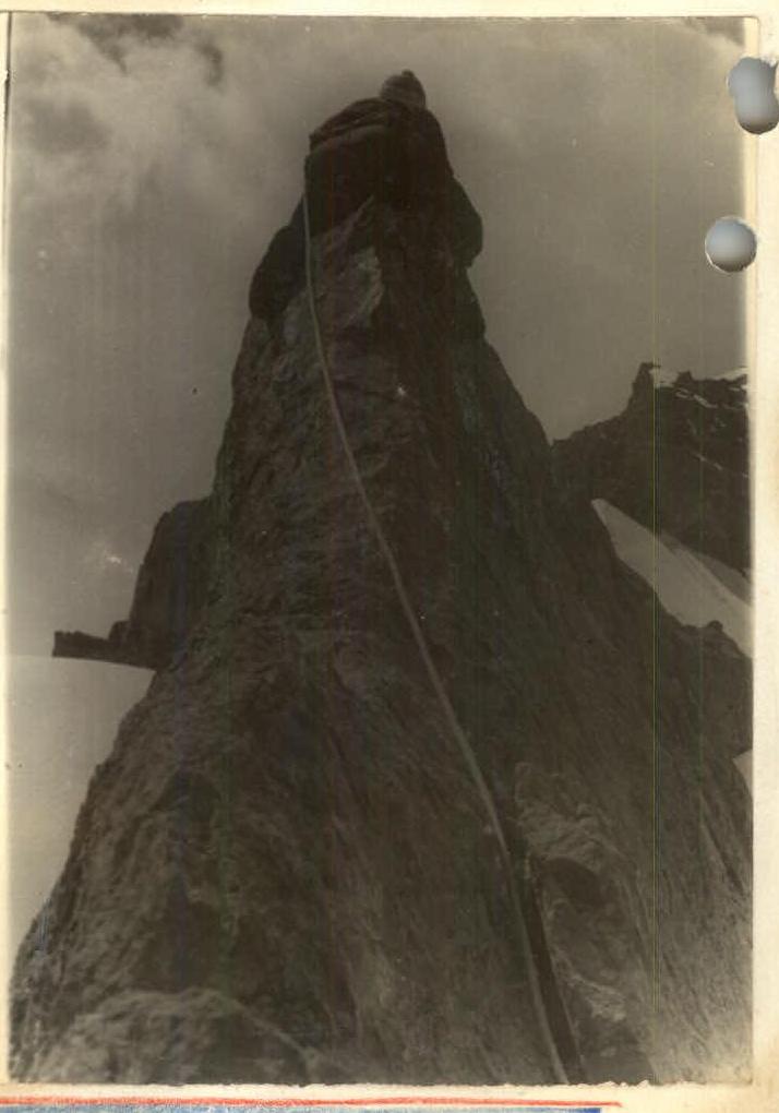
The further path to the summit goes along a narrow snowy ridge 100 m long to the base of the summit tower. The summit tower stands on a rocky-icy pedestal. The summit is a rocky spire 10 m high, completely sheer, with a small area at the top.
For insurance when exiting onto the summit, it is required:
- two rock pitons.
(photo #7)
The group reached the summit on August 5, 1958.
The path from the seventh "gendarme" to the summit takes 6–7 hours of rocky and icy work.
To descend from the summit, it is necessary:
- to return back along the ridge for 50–60 m;
- to descend to the southeast towards the OPTЭ pass into the cirque of the Shokalsky Glacier along a wide snowy-icy couloir with a steepness of 35–40°;
- to organize insurance through ice pitons in the upper part and through an ice axe - in the lower part;
- to make a descent 500–600 m long onto the firn field of the Shokalsky Glacier.
The upper part of Lake Shokalsky abounds with a large number of crevasses. Therefore, until exiting onto the flat part of the glacier, almost at the end of the described ridge, it is necessary to move with thorough insurance.
Descent time from the summit to the bivouac at the foot of the ridge: 3–3.5 hours.
Conclusions
- Being the highest point of an independent lateral ridge, the peak Bezymyannaya is a fully isolated peak suitable under the definitions of an alpinist object. The height of the peak is 4200–4250 m.
- The northeastern ridge is a completely logical path to the summit. The steep slopes of the ridge exclude any possibility of detours.
- The path to the summit and descent from it takes 17–18 hours of difficult work requiring the application of all mountaineering techniques. On the ridge, it is necessary to organize an intermediate night's stay.
- Based on the above, the group believes that this route should be classified as category 4B.
- The group requests that this peak be named "CHOKAN VALIKHANOV", in honor of the first Kazakh scientist.
Group leader - Master of Sports of the USSR (Shumikhin), 1958.
Participants:
- (Mansurov)
- (Zh. Kuznetsov)
- (Kolodin)
- (V. Zhuk)
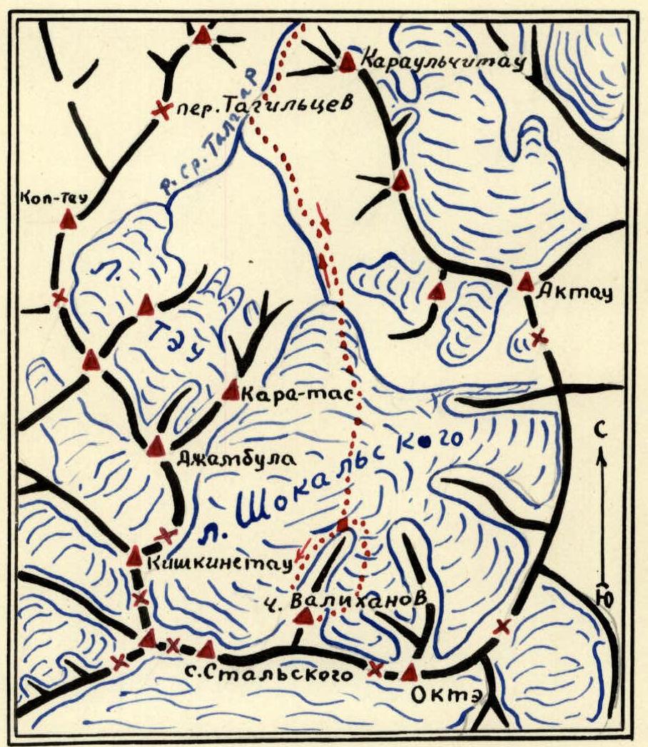
Route diagram
- places for overnight stays.
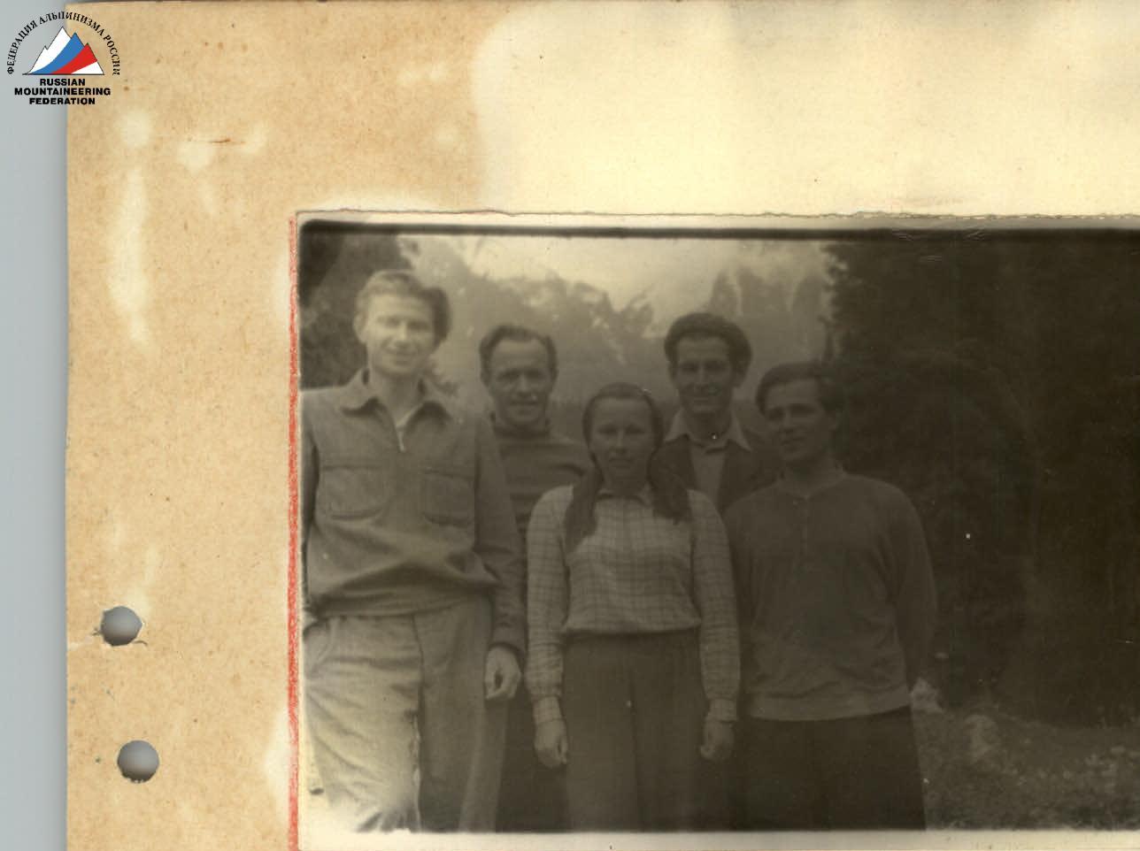
First ascenders: (rope team from left to right) V. Kolodin, P. Shumikhin, V. Zhuk, F. Mansurov, A. Kuznetsov.
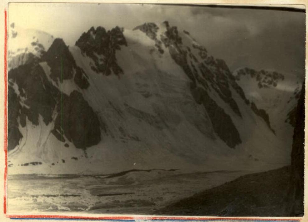
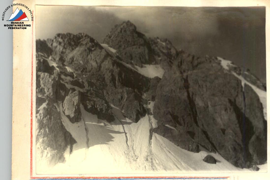
Photo #1
Comments
Sign in to leave a comment