Report on the ascent of Pik Yuzhny Talgar via the Southwest Wall, 5A category of difficulty, by the team of the Central Sports Club of the Army of Kazakhstan
Team coach: Uryubko D.V.
Team captain: Dedeshko B.E.
Almaty, 2010
Climbing Passport
- Zailiyskiy Alatau, Sredniy Talgar
- Pik Yuzhny Talgar — 4900 m
- Ice couloir through the center of the Southwest Wall
- Category of difficulty — 5A
- Route type — ice
- First ascent
- Height gain — 1000 m
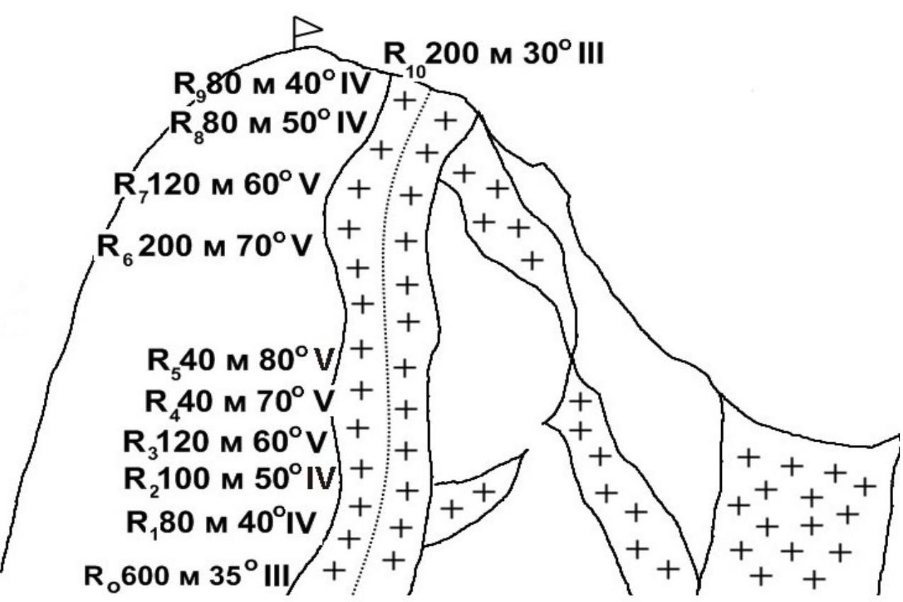
Route length — 1700 m. Section lengths:
- V category of difficulty — 25 m
- VI category of difficulty — none. Average steepness: 52°.
- Pitons left on the route: total — 0
Pitons used: Ice screws 75/0
- Team's total climbing hours on the route: 22 hours
- Participants: Uryubko Denis — Master of Sports of International Class
Dedeshko Boris — Candidate for Master of Sports, Trofimov Vadim — 1st sports category
- Coach: Uryubko Denis Viktorovich
- Departure for the route: August 9, 2010 — 4:00
Summit: August 10, 2010 — 20:10. Descent to bivouac: August 11, 2010 — 12:15
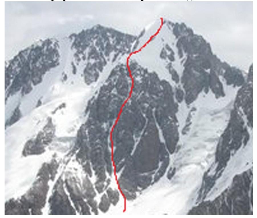
Photograph. Yuzhny Talgar Southwest wall
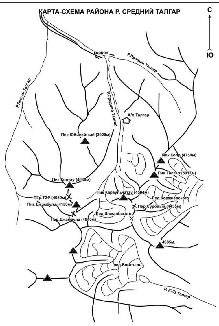
Map-scheme of the climbing area
Area: Zailiyskiy Alatau, Object: Sredniy Talgar
Group equipment
| № | Name | Quantity (pcs) | Weight (kg) |
|---|---|---|---|
| 1 | Tent | 1 | 3.5 |
| 2 | Gas burner | jetboil | 0.3 |
| 3 | Gas cylinders | 2 | 0.7 |
| 4 | Cookware | - | - |
| 5 | Rope 50 m — 10 mm | 2 | 7.0 |
| 6 | Hammer | 1 | 0.7 |
| 7 | Rock pitons | 5 | 1.0 |
| 8 | Protection equipment | set | 0.7 |
| 9 | Ice screws | 10 | 1.5 |
| 10 | Ice axes | 3 | 2.0 |
| 11 | Friends | set | 1.2 |
| 12 | Carabiners | 30 | 1.5 |
| 13 | Slings | 15 | 0.2 |
| 14 | Satellite phone | 1 | 0.4 |
| 15 | Radios | 1 | 0.2 |
| 16 | Expendable cord 5 m — 6 mm | 1 | 0.2 |
| 17 | First aid kit | 1 | 0.6 |
| Total | 21.7 |
Brief description of the climbing area
The Sredniy Talgar mountain area is significantly smaller than the Leviy Talgar area. To the west, the Sredniy Talgar valley is bounded by the Novy Otrog spur, and to the south and southeast by the Zailiyskiy Alatau ridge. Finally, to the east lies the Severny Otrog spur, which separates the Sredniy Talgar valley from the Pravy Talgar valley.
From the nodal vertex of the Stal'skiy ridge of the Zailiyskiy Alatau, a ridge stretches eastward in an arc, convex to the south, forming an extensive cirque of the Shokal'skiy glacier (length 5–6 km). The crest of the ridge is weakly dissected; in its middle part, there is an ice peak OPTЭ (4480 m), and the saddle west of this peak represents a difficult pass OPTЭ (around 4250 m), leading from the middle branch of the Shokal'skiy glacier to the Bogatyry glacier.
In the upper reaches of the right branch of the Shokal'skiy glacier, the Zailiyskiy Alatau ridge changes direction sharply, turning northeast. Its structure up to the Ak-tau peak is similar to the previous section: several unobtrusive unnamed peaks rise insignificantly above the ridge crest. Further on, the Ak-tau peak (4720 m) rises pyramidally above the ridge.
In the northwest spur of Ak-tau, predominantly rocky peaks rise:
- Karaul'chi-tau (4504 m),
- Chekist (4550 m),
- Salanova (4380 m).
The first ascent of the first two peaks was made by E. Kolokol'nikov's group in 1937.
From the Ak-tau peak and its crest to the northwest, the Kroksha valley glacier (about 2.5 km) descends, heavily broken by crevasses. A slight depression in the ridge, known as the Ak-tyuz pass (4440 m), connects the Kroksha glacier and the Korzhenskiy glacier.
Above the ridge crest, a series of rocky towers rise, stretching to the very foot of the Talgar massif, significantly towering above the surrounding peaks. The long crest of the massif has steep northern and southern edges. Above it rise three unobtrusive snowy peaks (from south to north):
- Yuzhny Talgar (around 5000 m),
- Glavny Talgar (5017 m),
- Severny Talgar (approximately 5000 m).
To the west and east from the Talgar massif, a series of short spurs branch off. In the northeast direction from the Talgar massif, in the main ridge, lies the massive nodal peak Metallurg (4800 m). Here, the Zailiyskiy Alatau ridge turns east.
From the Metallurg peak begins the Severny Otrog spur — the watershed between Sredniy and Pravy Talgar. The peaks of the Severny Otrog spur are predominantly rocky:
- Kara-tau (4140 m),
- V. Kolokol'nikov (4180 m),
- "GTO" (4080 m),
- and others.
The glaciers in this area, except for the Shokal'skiy glacier, are small, valley or hanging glaciers. The snow line is at an altitude of 3860–3900 m.
The first 9 km of the path to the Sredniy Talgar valley lie on the left side of the Pravy Talgar river and are passable by car. After a sharp turn to the south, a pack trail passes through a remarkably beautiful gorge of the Sredniy Talgar river. Four kilometers later, the gorge widens, and the trail, which earlier crossed to the right bank via a bridge, leads to the former Metallurg alpine camp (9 km from the mouth), bypassing several clearings.
Beyond the camp, the ascent to an ancient moraine begins soon, blocking the entire valley. On this moraine, at an altitude of 3050 m, the forest ends. From the moraine, a view opens onto a wide spur valley, closed to the south by the harsh cliffs of the Karaul'chi-tau peak, with the moraine accumulations of the Shokal'skiy glacier. Here, near a transparent and cold stream flowing from under the ancient moraine, the clearly marked trail ends.
From the former "Metallurg" camp to the tongue of the Shokal'skiy glacier — 5–6 km.
Preparation for the ascent
The ЦСКА MO РК team's training takes place regularly, year-round, and covers the entire spectrum of mountaineering training. The technical part of the training included practicing rock climbing techniques on the Ili river's climbing wall, on natural terrain, and during ascents in the winter conditions of the Tian Shan highlands.
Ascents are also made regularly — both as sports and training ascents. Therefore, the participants were well-prepared for the ascent of the given category of difficulty. The experience of joint ascents among the participants spans several years.
In previous years, the team had the opportunity:
- to familiarize themselves with the route,
- to study the tactical and climatic conditions,
- to plan the ascent schedule,
- to select the necessary equipment.
The process of year-round ascents provided the participants with constant acclimatization and high functional readiness.
Conducting the ascent
On August 3, the group departed from Almaty to Talgar by car. By evening, they reached the first bivouac at the former Talgar alpine camp.
On August 4, they ascended to the forest boundary at an altitude of 2800 m in a couple of hours. A clearing behind the so-called "Annapurna hill" became their base camp. Here, they set up a tent on a grid in the form of a house.
August 5–8 — ascents of 5th category of difficulty on:
- Pik Karaul'chi-tau,
- Pik Aktau,
- Tsentral'ny Talgar.
On August 9, at 4:00 in the morning, the team consisting of Uryubko Denis, Dedeshko Boris, and Trofimov Vadim set out on the route. The approach was not short, and after 5 hours, the team reached the route — to the ice couloir between the Snesarev and Meshkov routes. Having worked through eight ropes, the weather deteriorated sharply — a strong wind arose, and it started snowing. Moving aside slightly, they found a rocky ledge, where they decided to wait out the bad weather and set up a bivouac, around 15:00.
On August 10, early in the morning, they set out on the route; the weather was clear throughout the day. They worked until late evening — eight ropes — and reached the summit at 20:10. Descending slightly, they set up a tent on a snow cushion near the summit, not far from the Baranovskiy route.
On August 11, at 5:00 — descent to the base via the Baranovskiy route. They arrived at the base at 12:15. There were no mishaps, injuries, or illnesses. Communication with the base was maintained via radios.
Impressions from the ascent
Uryubko D. — This summer in Talgar, I got to feel the difference between how I approached my first 5A category route in 1993 and the ascents I made in 2010. Despite challenging weather conditions, the team made interesting ascents.
Dedeshko B. — I liked:
- the beautiful and logical line of the route;
- the fact that the route is flanked by rocks on both sides;
- the possibility of finding rocky ledges for comfortable bivouac organization.
Trofimov V. — Most of all, I was impressed by Denis's courage, working with a 57-meter rope on 5th-grade ice with only two intermediate ice screws. And we also had a fun descent on foot down the 4A ice. It turned out to be very fast and very scary, but nonetheless safe.
Pik Yuzhny Talgar, route via the ice couloir of the Southwest Wall
5A category of difficulty. Lepeshko
B