Ascent Passport
- Ascent class — combined
- Ascent area — Tian-Shan, Trans-Ili Alatau ridge.
- Peak — Peak Komsomola, height — 4376 m, route — along the north-eastern ridge (through the peaks Sneznoe plato, Lastochkino gnezdo, Ushbinka, Verblud).
- Estimated category of difficulty — 5A in winter.
- Route characteristics:
- height difference — 880 m
- average steepness — 50°
- length of sections with 5th cat. diff. — 315 m
- Pitons driven:
- for belay — 46, for creating RTO (basic technical points) — 1
- rock — 37
- ice — 9
- bolt — none
- Number of travel hours — 23
- Number of nights on the route — one, lying down
- Ascent participants:
- Reznik V.P. — Master of Sports, leader
- Ilyin A.N. — 2nd sports category, participant
- Lunyakov G.E. — 2nd sports category, —»—
- Prjanikov S.G. — 2nd sports category, —»—
- Team coach: Il'inskij E.T.
- Date of departure for the route — March 6, date of ascent — March 8, 1976.
Map-scheme of the ascent area
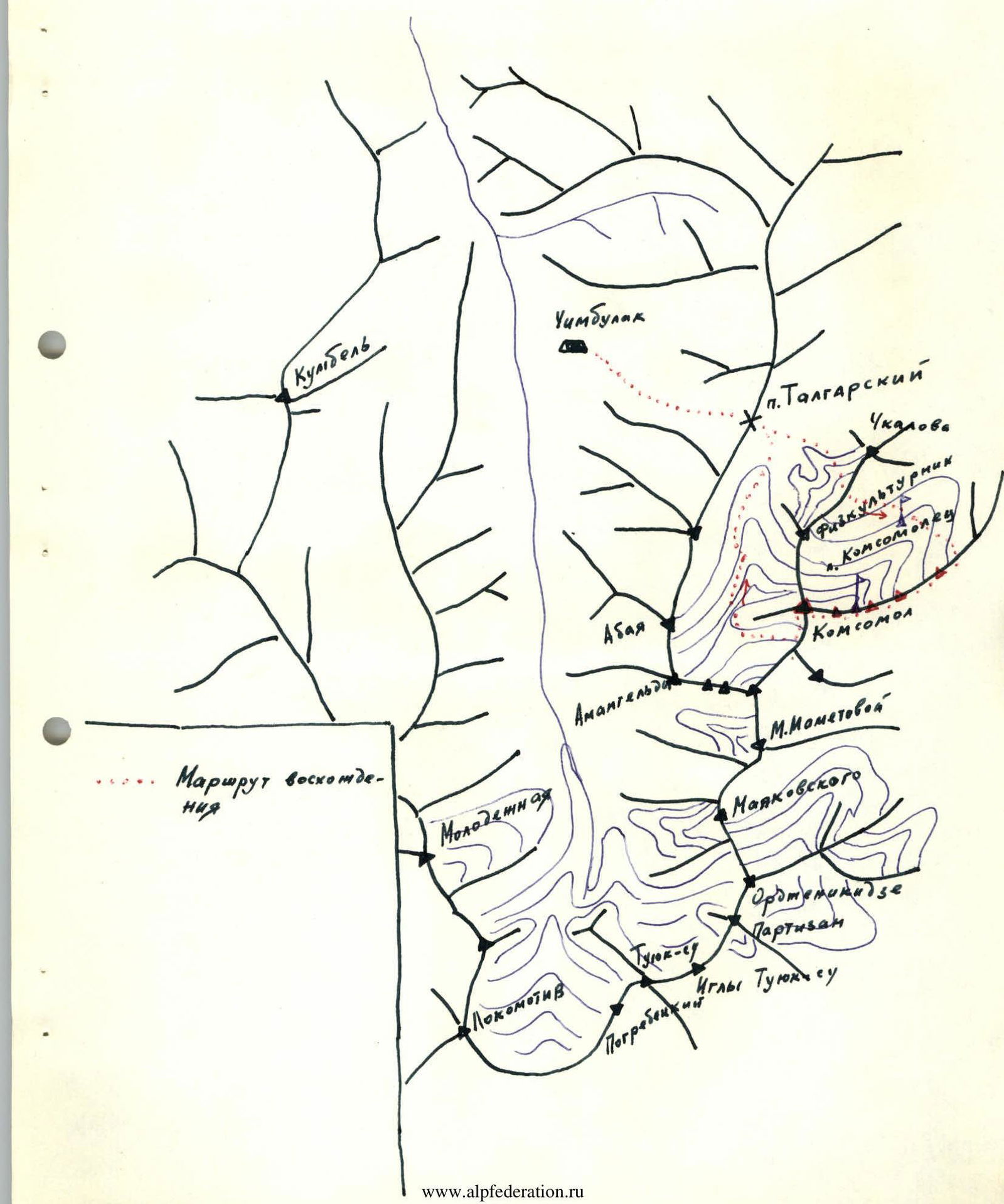
TABLE OF MAIN CHARACTERISTICS OF THE ASCENT ROUTE
| Date | Designation | Average steepness, ° | Length, m | Terrain character | Difficulty | Condition | Weather | Rock pitons | Ice pitons | Bolt pitons |
|---|---|---|---|---|---|---|---|---|---|---|
| 7.03.1976 g. | R0–R1 | 45 | 400 | snow-ice couloir | 2 | deep snow, avalanche danger | clear, frost | 5 | – | – |
| R1–R2 | 40 | 200 | rocky ridge | 2 | destroyed rocks, snow-covered | – | – | ledges | – | |
| R2–R3 | 50 | 80 | narrow ridge | 3 | solid rocks | – | – | ledges | – | |
| R3–R4 | 40 | 240 | rocky ridge | 3 | solid rocks | – | 2 | ledges | – | |
| R4–R5 | 60 | 120 | rocky wall | 4 | rocks covered with snow | – | 5 | ledges | – | |
| R5–R6 | 65 | 60 | rocky ridge | 3 | rocks covered with snow | – | ledges | – | – | |
| R6–R7 | 70 | 20 | rock wall | 4 | solid rocks | – | 2 | – | – | |
| R7–R8 | 80 | 80 | rocky wall | 5 | solid rocks | – | 10 | – | – | |
| R8–R9 | 25 | 50 | rocky ridge | 2 | solid rocks under snow | – | 1 | ledges | – | |
| R9–R10 | 65 | 60 | rock wall | 3 | rocks covered with snow | – | 3 | ledges | – | |
| R10–R11 | 90 | 25 | rock wall | 5 | monolith | – | 2 | – | – | |
| 8.03.1976 g. | R11–R12 | 20 | 60 | ledges | 3 | destroyed rocks | – | ledges | – | – |
| R12–R13 | 20 | 100 | snowy ridge | 2 | deep snow | – | – | – | – | |
| R13–R14 | 80 | 30 | rock wall | 5 | solid rocks | – | 4 | – | – | |
| R14–R15 | 45 | 40 | rock ascent | 4 | solid rocks | – | 4 | – | – | |
| R15–R16 | 35 | 300 | narrow rocky ridge | 3 | heavily snow-covered | – | ledges | – | – | |
| R16–R17 | 60 | 50 | ice ascent | 4 | clean solid ice | – | 4 | – | – | |
| R17–R18 | 40 | 150 | snow-ice wide ridge | 4 | avalanche danger | – | on ice-pick | – | – | |
| R18–R19 | 50 | 80 | snowy ridge with cornices | 5 | avalanche danger | – | on ice-pick | – | – | |
| R19–R20 | 50 | 100 | ice ridge | 5 | dangerous, cornice above | – | 5 | – | – | |
| R20–R21 | 60 | 5 | snowy cornice | 4 | dangerous | – | – | – | – |


Brief description of the approach to the route
From the Chimbulak ski base along the support of the suspension road, through the Talgar pass, along the Bogdanovich glacier to the slopes of Peak Chkalov under the tongue of the hanging Til glacier — 5 hours walking. The approach is significantly complicated by the abundance of snow and the need to have a supply of warm clothes, gasoline and safety equipment in conditions of increased avalanche danger, and food for 4 days. On the smoothed rocks covered with snow and small stones to the left of the hanging glacier, reach the snow plateau, cross it and rise to the saddle between the peaks Fizkulturnik and Chkalov via simple, snow-covered rocks. The snow on the plateau is dry and loose, with a depth of 1 m or more.
Descent from the ridge to the Komsomolets glacier via simple rocks and talus covered with deep snow. On the glacier — overnight stay. From the overnight stay, 30 minutes walk to the base of the wide couloir leading to the saddle before the peak Sneznoe plato. There is a lot of snow on the glacier, and a trench has to be dug.
The approach from "Chimbulak" to the start of the route takes 8–9 hours.
Brief explanation for the table
The ascent through the vertical inner corner to "Ushbinka" (R7–R8) and the first 30 m of the 70-meter wall (R13–R14) are the most difficult rock sections of the route. Here it is necessary to pull up the backpacks, and the rocks are covered with ice in some places. Since it is cold, it is necessary to move in fur gloves. Very careful belay is required!
On most rocky areas, it is necessary to clear snow from handholds and footholds.
The R18–R19 section is very difficult to overcome. It is a ridge with cornices on both sides. One cornice has to be hacked through. It is avalanche-prone and very cold here, with a continuous strong wind blowing almost along the ridge. The belay is not reliable here.
The upper part of the steep ice ridge leading directly to the summit is the most difficult to overcome and is dangerous due to the powerful cornice hanging above the ridge. This cornice has to be hacked through.
Description
Traverse of Peak Komsomola (4376 m) along the NE ridge in winter conditions
From the Chimbulak ski base, ascent through the Talgar pass to the moraine of the Bogdanovich glacier and further to the wide snow plateau to the left of the hanging Til glacier along a snow-covered talus couloir and rocks. Exit to the saddle between the peaks Chkalov (left) and Fizkulturnik (right) at first along the snow plateau covered with deep, up to 1–1.5 m, loose dry snow, then along snow-covered simple rocks, descent to the Komsomolets glacier along a wide couloir covered with deep loose snow cover. A similar snow cover, in which it is necessary to dig deep tracks, sometimes a trench, is common on the Komsomolets glacier, which must be crossed, heading towards the couloir leading to the NE ridge. The couloir with a steepness of 40–45°, 400 m long, is covered with deep snow, moving directly along it is practically impossible and dangerous due to the possibility of avalanches, so it is passed along the edge of the rocks, smoothed, of medium difficulty, with belay through pitons and ledges. After exiting to the "Plato", a simple path along the ridge (easy rocks, snow-covered, in places the depth of the snow under the rocks is waist-deep) with simultaneous belay to the gendarme "Lastochkino gnezdo".
Ascent to the gendarme — along snow-covered rocks of medium difficulty with alternate belay through pitons and ledges.
Descent — simple, climbing, at the end — with alternate belay, under "Ushbinka".
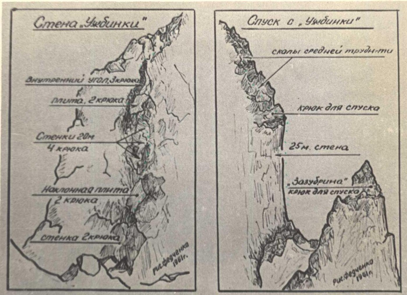
Ascent to "Ushbinka":
- along difficult rocks to the right from the saddle;
- along a vertical inner corner turning into an inclined ledge in the upper part;
- with careful piton belay — on two ropes, 10 pitons;
- the first twenty meters — one backpack is pulled out.
Features of the wall:
- rocks are slightly snow-covered, but in places covered with rime ice;
- on the ledge — heavy snow cover, handholds have to be searched for by digging through the snow.
The summit of "Ushbinka" and the beginning of the descent are simple. Further descent from "Ushbinka" — sitting, on a rope (one 40 m rope). A loop is hung for descent.
From the saddle — exit to a tooth along medium snow-covered rocks. Descent from the tooth — by sports method (20 m) and along simple rocks.
Passing a simple gendarme — through its summit along heavily snow-covered rocks of medium difficulty (searching for handholds) with alternate and simultaneous belay.
From the saddle after the gendarme — ascent to a 70 m wall:
- steepness in the lower part — 80°, in the upper part — 45°;
- to the left of two oblique cracks;
- the path goes straight up 30 m (the first climber's backpack is pulled out), then left-up 40 m;
- careful piton belay (8 pitons).
Features of the wall:
- handholds are covered with rime ice;
- on the oblique ascent left-up on the slabs lies a layer of granular snow, which has to be thrown off to search for footholds and handholds.
Further — simple and medium snow-covered rocks to the ascent to "Verblud".
The saddle before "Verblud" is covered with dense wind crust only in the middle part for a length of 15–20 m, sinking to the depth of a foot; the rest of the saddle, the ascent to "Verblud", both humps of "Verblud" are covered with dry loose deep (waist-deep and higher) snow. Moving up through the snow is practically impossible. "Verblud" is overcome to the left of the ridge along the rocks and the boundary with the snow, with simultaneous and alternate belay through ledges.
The pre-summit ascent is covered with deep snow, to the right — a cornice, then a narrow snow ridge, along which movement is dangerous due to the possibility of avalanches, especially at the end of winter, when snowboards are formed here, as on the humps of "Verblud".
The ascent is overcome:
- in the left part of the ridge;
- along rocks of medium difficulty, in places difficult;
- along the boundary with the snow;
- with alternate belay through ledges.
The upper part is the most difficult, steepness up to 50° (careful belay!); when exiting to the junction of the NE ridge with the NW one, a snow cornice hangs overhead, which has to be hacked through.
Exit to the summit and descent via the path of 2A cat. diff.
The description was compiled by a group of climbers from the Kazakh Republican Alpine Club consisting of:
- Reznik V.P. — Master of Sports
- Ilyin A.N. — 2nd sports category
- Lunyakov G.E. — 2nd sports category
- Prjanikov S.G. — 2nd sports category
who completed the ascent from March 6 to 8, 1976.
Group movement schedule:
- Departure from "Chimbulak" on March 6, 1976, at 11:00. Overnight stay on the Komsomolets glacier.
- Departure from the 1st overnight stay on March 7, 1976, at 8:30. Overnight stay behind "Ushbinka" on the saddle.
- Departure from the 2nd overnight stay on March 8, 1976, at 8:30.
- Exit to the summit on March 8, 1976, at 16:00.
- Descent to the g/l base "Chimbulak" at 19:30.
Special equipment of the group:
- Main rope 12 mm — 2 pcs. 40 m each.
- Repschnur consumable — 20 m.
- Rock pitons — 16 pcs.
- Channel pitons — 6 pcs.
- Hammers — 2 pcs.
- Ice axe — 1 pc.
- Group carabiners — 3 pcs.
Conclusion on the route.
In winter conditions, a rather complex and interesting nature of the route is further complicated by the presence of the following factors:
- Heavy snow cover on the rocks, in places rime ice, hiding handholds, the need to clear rocks from snow for their passage. The NE exposure of the ridge makes this factor act throughout the winter.
- The presence of a large amount of loose snow, weakly connected to the snow on the glaciers, talus, ridges, saddles, overcoming which requires enormous effort and time. In some places, an avalanche hazard is created.
- Low air temperature, especially in combination of low temperature and the absence of direct heating of rocks and climbers by the sun's rays β (NE ridge!) makes it necessary to pass complex rock sections in down and fur gloves, which significantly complicates their overcoming.
- In winter conditions, the number of convenient places for overnight stays decreases, as the saddles usually used in summer are blown by strong winds, creating uncomfortable conditions, and there are no more than two places reliably protected from the wind on the ridge.
- The psychological factor of significant remoteness of the ridge from the base and usual climbing routes is of great importance, as well as the impossibility of quick retreat in case of complications.
The route along the NE ridge of Peak Komsomola in winter conditions fully corresponds to 5A cat. diff. It is recommended only for a well-prepared group with experience in winter ascents, not more than 6 people, and only in good weather.
Group leader / Reznik V.P., Master of Sports, instructor cert. No.2143 /


