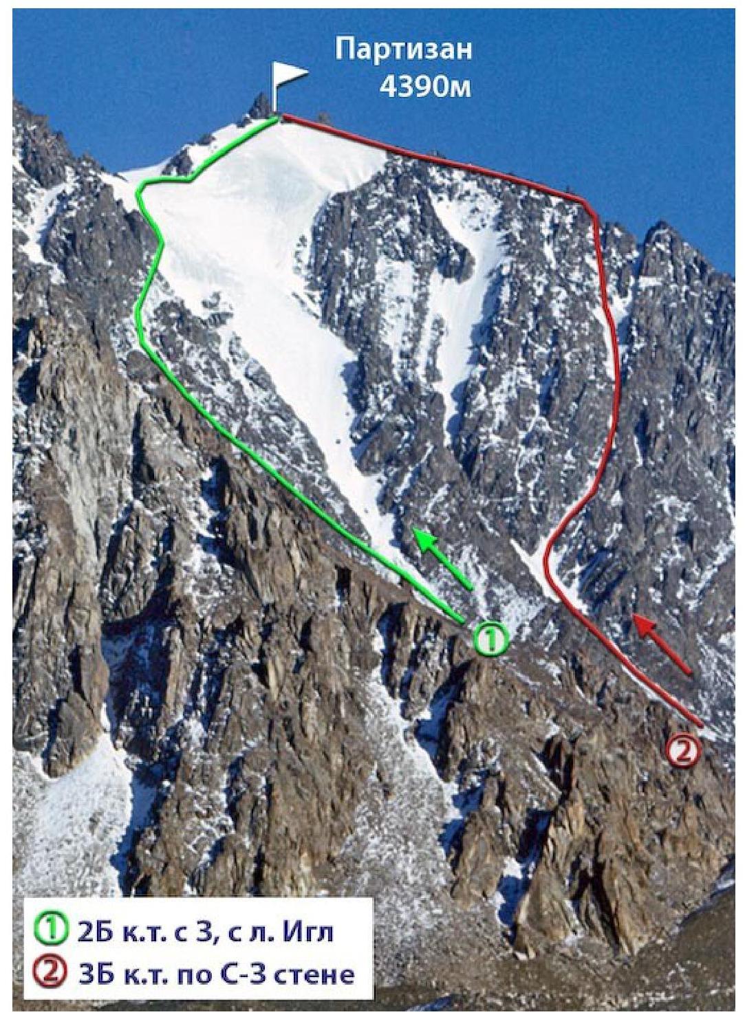
Partizan ZB c.l. via North-West face
Route description.
The ascent begins by approaching the north-west face of the peak via the Igly Tuyksu glacier. Here, on the moraine, is a convenient location for the initial bivouac. The route starts with an ascent up a firn slope, leading to a couloir (steepness 30–35°, prone to rockfall).
After ascending 200 m, turn into the right branch of the couloir, cross it in its lower part, and exit to the right onto a rocky ridge, continuing along it. Certain sections require careful belaying. In the lower part of the ridge, the rocks are smoothed, and small terraces are encountered.
After 50 m, there's an exit to difficult, sheer rocks. Piton belay is necessary (3–4 pitons).
Further, for 100 m, the route follows rocks of medium difficulty to a saddle, where the right and left ridges, forming the couloir, converge.
Then, there's a section of easy rocks, with scree and snow intermixed, leading to the most challenging, key section of the ascent.
There are two options for overcoming this segment of the route:
- The first is a 60 m ascent up the rear, icy wall of the chimney (steepness 65–70°). It requires step-cutting and piton belay.
- The second is an ascent to the left up the chimney, which is no more than one and a half meters wide and has a steepness of 70°. The chimney is clogged with snow and ice, blocked by plugs, stacked one above the other. The height of the chimney to the plugs is 10–12 m. The first plug is passed on the left, the second on the right. Belay is via pitons.
After the plugs, a couloir begins, the bottom of which is covered with fine scree. Ascend it, sticking to the right side. Then:
- Approach a 2-meter wall via destroyed rocks of medium difficulty,
- Overcome the wall,
- Ascend to a platform made of inclined slabs (proceed with great caution: rockfall is possible).
From here, move upwards along the rocks, bypassing the barrier to the right via terraces and slabs, until intersecting with a wide couloir, continuing the ascent to the left onto a counterfort leading to the main ridge. The length of this section from the slabs to the main ridge is about 150 m.
Along the main ridge, move to the left. Two gendarmes, 8 and 5 meters high, are encountered and can be overcome head-on; they can also be bypassed on the left with a slight loss of height.
Beyond the gendarmes:
- A wide, icy ridge leads to the southern summit of Partizan peak.
The ascent to the summit tower from the south-east side follows slabs, turning left, exiting onto a rocky saddle, from where, along the outer angle, onto the ridge leading to the southern summit. Descent from the southern summit follows the ascent route.
The ascent to the northern summit tower is from the west, along the right outer angle, exiting onto a section of slabs with slight steepness. Further, along a narrow, jagged chimney and ridge, ascend to the northern summit of Partizan. Descent follows the ascent route.
Descent via route 2B through Partizan glacier. The entire ascent takes 11–12 hours. The route on the north-west face was first traversed on September 12, 1945, by mountaineering instructors P. Semenov and G. Shchur.
Recommendations:
- Number of participants — no more than 4 people.
- Initial bivouac on the moraine of Igly Tuyksu glacier.
- Departure from bivouac at 3:00 AM.
- Equipment for a group of 4 people:
- Main rope — 2×30 m
- Expendable cordelette — 10 m
- Rock pitons — 6–7 pcs.
- Ice pitons — 5–6 pcs.
- Hammers — 2 pcs.
35 c.l. via N-W face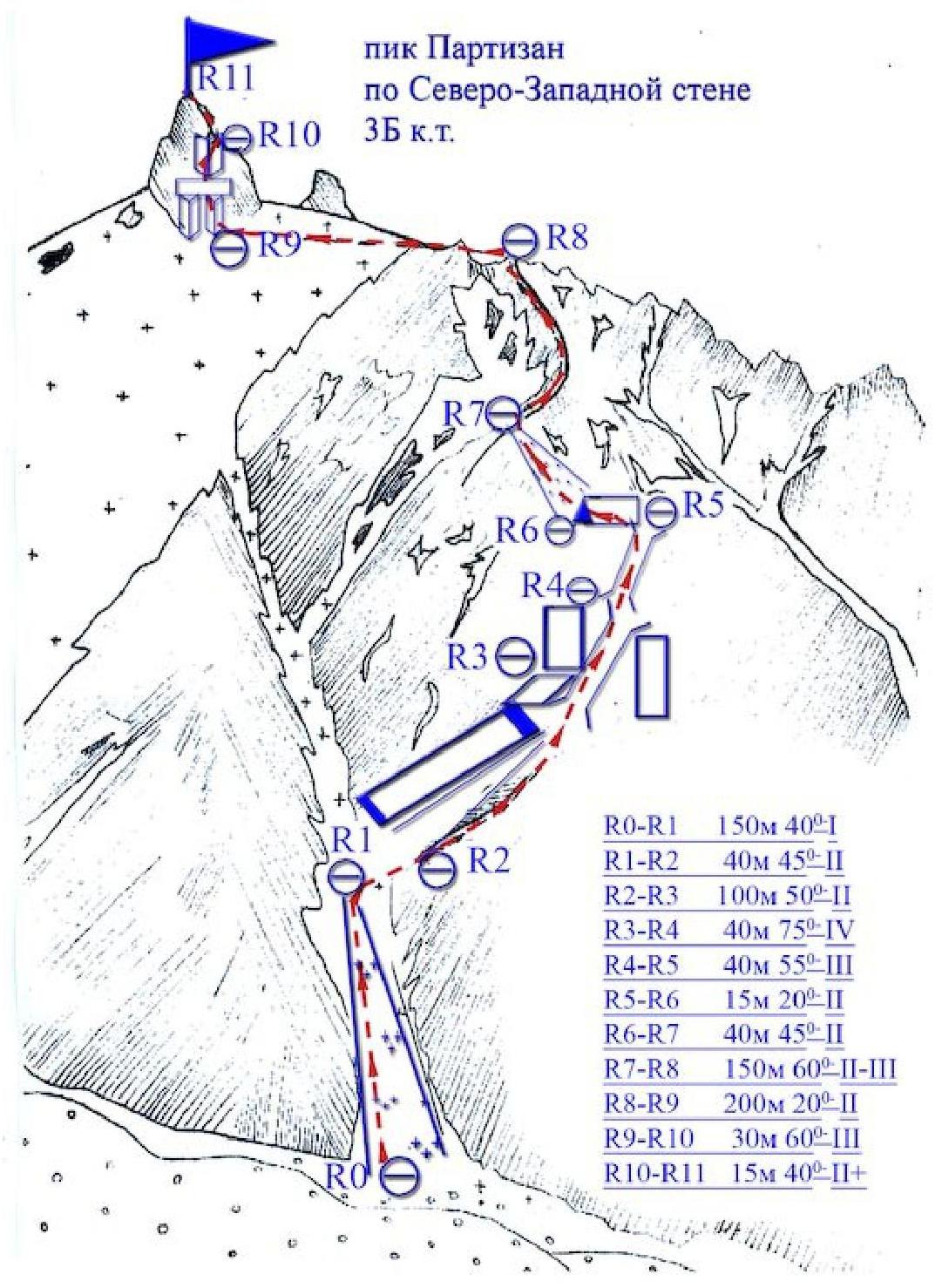
Author: Zhunusov B. Source: Book "Alpinistskie marshruty. Zailiysky Alatau". Part 1
From Mountain.kz website