Sportclub "Burevestnik" Group
consisting of:
-
Ilyinsky E.T. — leader, experienced climber
-
Toporkov A. — participant
-
Shablitskaya L. — experienced climber
-
Nevsky Ya. — experienced climber
-
From Myndzhilki, we ascended to the Tuk-Su moraine via a trail. From the foot of Mayakovsky, we had to trample a trail to the Ordzhonikidze Pass. The snow had become soggy by then and sank up to the waist. We spent the night on the pass as we reached it by the fourth hour.
-
The next day, we descended to the east Ordzhonikidze glacier. Initially, we traversed an scree slope, followed by a 60° ice slope. We traversed the glacier until we reached the terminal moraine beneath the northeast ridge's rock wall. The descent took 2 hours and 30 minutes. Then, we ascended towards the first rock wall via very deep snow. The ascent was directed towards a rock island standing before a couloir that led to the ridge (photos 1 and 2).
The rock island was initially ascended directly via broken rocks. In the upper section, it was bypassed to the left via a 60° ice slope (1 rope length) with step-cutting, as the snow did not hold. Upon reaching the rock island, we continued ascending via the couloir to the left of our route. The first 1.5 rope lengths consisted of ice up to 70°, which was traversed with step-cutting and piton belay (2 pitons). Then, the slope became gentler, and the couloir was filled with snow above human height. Due to the loose snow and avalanche danger, we had to exit to the left wall and traverse diagonally upwards to the right with piton belay (3 rope lengths) — exiting into the upper section of the couloir. From here, a heavily snow-covered slope of approximately 45° led to the ridge (2 rope lengths).
The ridge consisted of broken, heavily snow-covered rocks (photo 3). On the ledges and slabs, the snow reached up to 1 m or more in thickness. Movement occurred along the ridge. Two pinnacles were traversed from the left, and we reached the first cairn. From the cairn, the first pinnacle was bypassed to the left, and the second was bypassed to the right. Caution was required when traversing the pinnacles as the snow lay on the slabs and could slide. After the second pinnacle, a steep snow-covered slope led to the base of the second wall. Immediately after the second pinnacle — we spent the night in a small snow depression.
- The group began ascending in the direction of the visible ice gully in the middle of the wall (photo 4). From the base of the wall, an ice couloir led to a ledge at up to 60° (1 rope length to the left and upwards), with a wall on one side, allowing for reliable belay. Then, via ledges with a steepness of up to 40–50°, we approached the wall itself. It was not possible to follow the summer route as the wall was almost entirely covered in ice and heavily snow-covered in some areas (photo 6). The most suitable path was to the right via ledges (photo 4), followed by an exit to the upper section of the couloir. This part of the path consisted of inclined ledges with a steepness of up to 50–60°, with a massive snow cover and height differences between ledges ranging from 3 to 15 m of difficult rock. The path was complicated by the fact that the rock was covered in ice and a thick layer of snow, forming ledge-like cornices that greatly slowed our progress — we had to constantly chip away at them and clear the snow before finding handholds. The length was 4 rope lengths with careful belay, followed by an exit to the upper section of the Ice Gully (photo 8).
Then, the path led via difficult, loose rocks with piton belay (2 rope lengths). Further, there was a section of ice up to 60° and approximately 10 m long, requiring step-cutting, which led to a smooth slab with a narrow crack in the middle. The slab was about 10 m. With careful piton belay, we traversed the slab, chopped through a cornice, and exited onto a lateral ridge, which led into a steep, snow-filled couloir. As night began to fall, we had to stop. The couloir was steep, up to 60°, but the snow was so deep that we managed to carve out a platform for the tent near the wall; due to the great steepness of the slope, we had to thread a rope through the tent and secure ourselves.
- Ascending the couloir (2 rope lengths). The deep snow was mixed with ice sections in some areas. Further, via a ledge, we ascended to the right and upwards (2 rope lengths), which led to a small wall up to 6–8 m of difficult but solid rock, and then again via a ledge to the right. We exited onto the main ridge above the second wall. Then, again, a small vertical wall of 6–8 m. To traverse it, we stood on a teammate's shoulders and thus reached a small ledge where we could stand; then, we hammered in a piton and used it as an artificial handhold to ascend. Then, having traversed half a rope length along the ridge, we reached a chimney (photo 9). To traverse the chimney, we had to chip away ice from the side walls. Further, after half a rope length, we encountered a cornice (photo 10); to traverse it, we had to chop away its upper section. After that, the group exited onto the main ridge, the so-called "triangle peak." Here — the second intermediate cairn.
The ridge with cornices to the left was initially gentle, then increased in steepness and approached a smooth ice wall to the first pinnacle, which was bypassed to the left via inclined, heavily snow-covered ledges and then via the second pinnacle along heavily broken rocks of medium difficulty. The second pinnacle was also bypassed to the left; the third pinnacle was taken head-on via rocks of medium difficulty. After the third pinnacle — we spent the night in an ice depression.
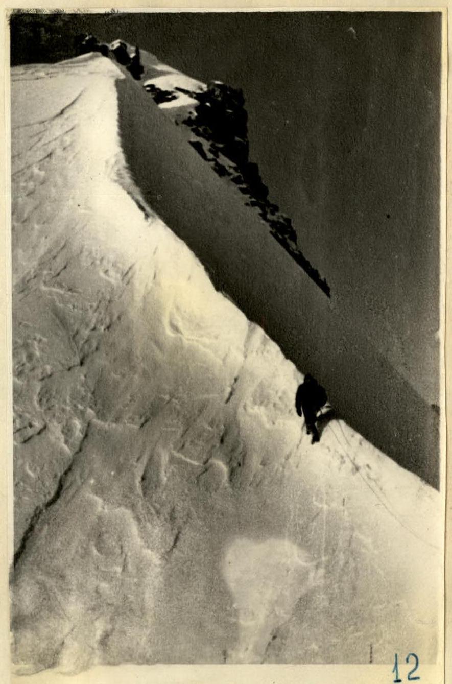
The fourth pinnacle was taken head-on via easy rocks. The fifth pinnacle was traversed head-on via ice-covered and broken rocks (1 rope length). From the fifth pinnacle, a steep ice ridge with cornices to the left (photo 11) led to the sixth pinnacle (4 rope lengths). The latter was bypassed to the right via rocks of medium difficulty. From the sixth pinnacle, an ice ridge of the same character with a steepness of up to 50–60° and large cornices to the left followed; then, the steepness increased to nearly vertical, and the ridge approached the junction with the lateral ridge as a sharp ice edge (4 rope lengths). From the junction of the ridges, the path led along the main ridge, initially descending (3 rope lengths). The ridge was snow-and-ice with cornices to the right; to the left, a slope descended at 60–70°. This section was traversed with piton belay. Then, a snow-and-ice ascent followed (1 rope length); from the bend, the ridge quickly increased in steepness (photo 12) and rose as a nearly vertical ice edge (3 rope lengths) to a gentler section. Further, after chopping through a cornice, we exited to the junction with the eastern ridge. With step-cutting, we traversed this section and then along the snow-and-ice ridge with a steepness of up to 50° and cornices to the right approached the pre-summit shoulder, from which a snow cornice overhung. When traversing this section along the ridge (6 rope lengths), all encountered rock pinnacles were taken head-on. The last rock massif before the cornice was bypassed to the right via a steep snow slope with belay using rock pitons.
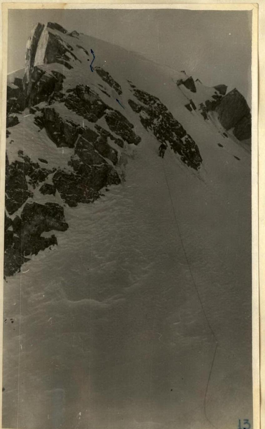
Having ascended the slope, we chopped through the cornice and exited onto the pre-summit shoulder. The pre-summit shoulder was a gentle ridge with cornices to the right and slopes up to 60° to the left. Along the way, we encountered 3 pinnacles, which were taken head-on via gentle ice-covered rocks. The last pinnacle before the summit was bypassed to the right via broken rocks and led to a small saddle, from which an ice slope led to the summit (photo 13).
From here to the summit — 2 rope lengths; the slope with a steepness of up to 70° led to rocks (photo 13), but they were covered in ice, so we had to navigate between rock islands. The ice was covered in powder snow, which we had to clear and cut steps through. To the right, the slope dropped away as the north wall. This section was traversed with careful piton belay. Then, the slope became gentler, and after half a rope length (0.5 rope lengths), the group reached the summit. Descent was via route 3A and further along the ascent path to the pass.
Time: from December 31, 1963, to January 4, 1968 (according to the document's dates; details in the log below)
- Mandzhilki — Ordzhonikidze Pass (R7–R4), 9 hours
- Ordzhonikidze Pass — 1st night's halt (R9–R5), 8 hours
- 1st night's halt — 2nd night's halt (R9–R7), 10 hours
- 2nd night's halt — 3rd night's halt (R11–R5), 6 hours
- 3rd night's halt — Myndzhilki (R8–R11), 15 hours

The group considers that the route to Ordzhonikidze Peak via the northeast ridge in winter conditions, with the snow cover that was present this year, deserves a 4B category of difficulty. Compared to previously traversed routes, particularly the Aksai Saddle, we believe that this assessment is accurate.
The description was compiled by the group leader (Ilyinsky E.T.) February 20, 1964