North Tien Shan, Zailiyskiy Alatau
Peak Ordzhonikidze
via the right part of the North Face
Category 4B difficulty
Ascent Passport
- Type of ascent: technical
- Ascent area: North Tien Shan, Zailiyskiy Alatau, Maloe Almatinskoe gorge
- Peak, route: Peak Ordzhonikidze (4410 m), via N slope, first ascent.
- Proposed category of difficulty: 4B, combined
- Elevation gain: 600 m
total route length — 840 m, wall section length — 720 m, out of which 5th category section — none, 6th category section — none, average steepness of wall section — 60°, average steepness of the route — 50°
- Number of pitons hammered in (denominator for IT):
- rock pitons — 6/0
- ice screws — 47/0
- chocks — 0
- bollards — 0
- Number of climbing hours/days: 8/1
- Overnight stays: none
- Leader — Pivtsov Vasily Talgatovich, 1st sports category
Participants:
- Molgachev Damir Sergeevich, 1st sports category
- Rudakov Alexander Yuryevich, 1st sports category
- Skopin Artem Alekseevich, 1st sports category
- Coach: Ilyinsky Ervand Tikhonovich, Honored Coach of the USSR
- Departure to the route: January 29, 2000, 6:30 AM
Summit: January 29, 2000, 2:30 PM. Descent: January 29, 2000, 6:00 PM.
Map-diagram
of the area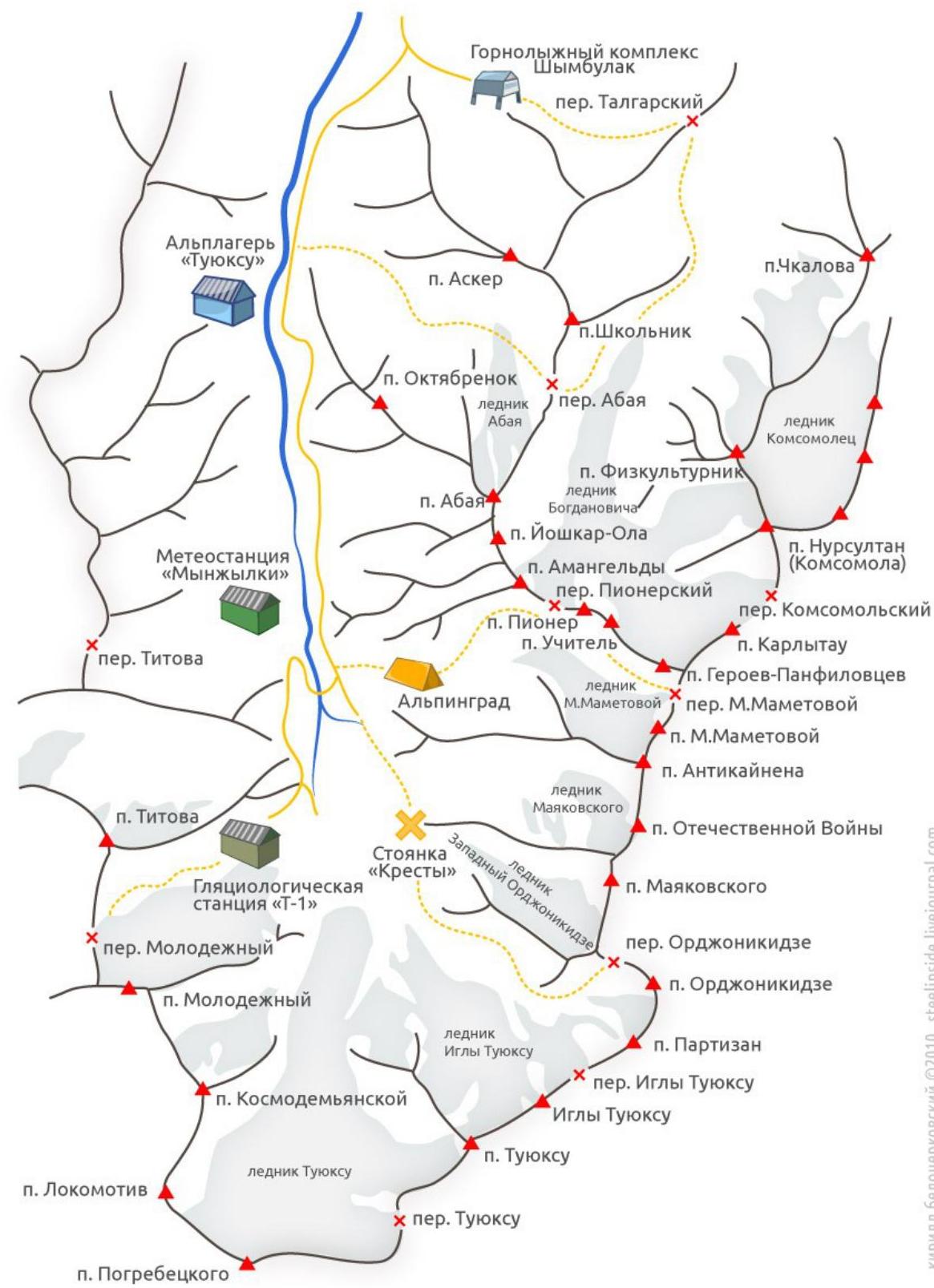 n.
Pogrebetskogo
n.
Pogrebetskogo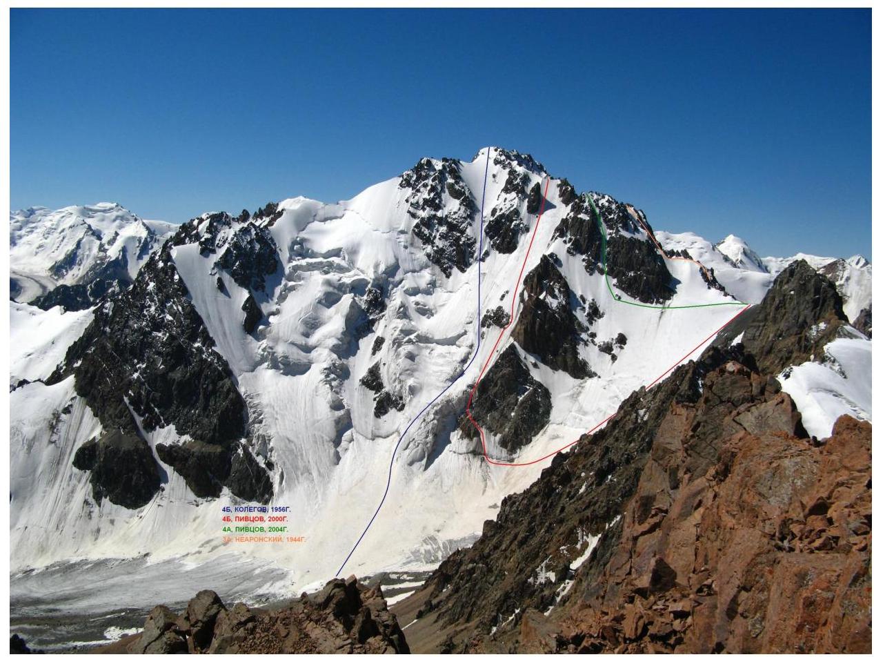
Route Description
Descending from Ordzhonikidze pass, it is necessary to bypass the rock counterfort descending onto the East Ordzhonikidze glacier. The route begins at the bergschrund located between the counterfort (right) and the rock triangle (left).
To the bergschrund — movement with simultaneous belay.
From the bergschrund, keeping close to the rock triangle:
- Two rope lengths, steepness up to 60°, lead to an ice ridge under the serac.
- Further along the ridge, steepness 45° and length 45 m, approach under the triangular rock, under which a belay station is set up.
- The next rope length, steepness up to 65°, passes through a narrow ice couloir between the counterfort and the rock island.
- This rope length leads to a snow field, steepness up to 50° and length 140 m.
Further:
- Bypass the rock island on the right.
- Stick to the direttissima.
- From the rock island, the route starts to curve and in the upper part reaches 65°.
- The wall ends with a ridge, along which, after 150 m, the summit is reached.
Additional information:
- In summer, the route may be prone to rockfall.
- Belaying is done through ice screws, but due to the proximity of rocks, the use of pitons, chocks, etc. is possible.