Description of the Ascent to Peak "Mayakovsky" via the Northwest Wall (Upper Section)
A group from the Republican Club of Mountaineers and Tourists consisting of:
- REZNIK V. P.
- SHKLYAR G. Z.
- SAVIN V. I.
- PETRASHKO G. A.
Led by (signature)
Alma-Ata 1962
Peak "Mayakovsky" is located in one of the ridges of the Trans-Ili Alatau range. It is situated in the cirque of the Tuyuk-Su glacier, from which the Malaya Almaatinka river originates.
The summit is positioned between the peak "Otechestvennaya Voyna" and the Ordzhonikidze pass. Currently, there are several routes to the summit:
- Along the northern ridge, from the saddle between the peak "Otechestvennaya Voyna" and Peak "Mayakovsky", 3A category of difficulty.
- Along the southern ridge, from the Ordzhonikidze pass - 3B category of difficulty.
- Via the western wall with an exit to the southern ridge - 3B category of difficulty.
- Via the southeast wall - 4A category of difficulty.
The most interesting of these is the southeast wall (first ascent by Savukhin), 4A category of difficulty.
In the spring of 1961, a group undertook a training ascent in this area and noticed the steep western wall of Peak Mayakovsky. After some time, the group specifically went under the wall to take photos and observe it. The wall was photographed using a Jupiter-11 telephoto lens and carefully examined with binoculars. The route is generally obvious: a horizontal traverse along a ledge, followed by an ascent via an internal angle directly to the summit. However, upon closer inspection, a more detailed path was planned, largely avoiding the upper part of the angle due to its complicated terrain. The group largely followed the initially planned route.
Concerned about the possibility of rockfall, we decided to observe it. Throughout the day, we noticed only three rockfalls in the second half of the day. Their path lay away from the main section of the route.
The ascent was decided to be undertaken in the spring of 1962.
Description of the Ascent Route
On the wall of Peak "Mayakovsky" on April 15-17, 1962.
On April 15, a group from the Republican Club of Mountaineers and Tourists consisting of:
- Reznik V. P. - leader
- Shklyar G. Z.
- Savin V. I.
- Petrashko G. A.
embarked on the ascent of the wall. The group was equipped with the following gear:
- Boots - 4 pairs
- Slippers - 2 pairs
- "Zdárka" tent
- Main ropes, 40 meters each - 2 ends
- Auxiliary rope, 50 meters - 1 end
- Repschnur - 8 pieces
- Belts - 4
- Carabiners - 12 pieces
- Pitons:
- horizontal - 5 pieces
- vertical - 10 pieces
- thick duralumin - 5 pieces
- Hammers - 2, Ice axe - 1
- Three-step ladders - 2 pieces
- Backpacks - 4
- Stormproof suits - 4
- Down suits - 4
- Sweaters - 8
Provisions were taken at a rate of 200 grams per person per day. Additionally, about 2 liters of water were taken on the route, as the group did not notice any signs of water or ice on the wall during their observation, and snow did not linger on it due to the steepness (70–80°).
Approach. On the first day, the group made their approach to the wall.
The approach is similar to the routes 3B western wall and 3A northern edge.
From the "Tuyuk-Su" alpine camp, we ascend along a good path to the "Myn-Zhilki" weather station. Then we proceed to the terminal moraine of the Tuyuk-Su glacier. One must move to the right side of it (here and further, the orographic side is indicated). Along the bed of the uppermost tributary of the Malaya Almaatinka, we go upwards, between a gentle slope from the northeast and a moraine from the southwest. This stream leads us to the moraine of the "Otechestvennaya Voyna" glacier.
Here one must:
- reach the crest of the Tuyuk-Su glacier moraine and move along it, constantly veering to the left;
- after about 500 meters, reach the moraine of the "Mayakovsky" glacier and move along its right side, on a well-trodden path;
- overcome a gentle ascent leading to a small ice fall, which we circumvent via scree, staying closer to the rocks;
- proceed another 200 meters of a gentle ascent;
- skirt a lateral ridge and emerge onto scree descending to a saddle;
- ascend a steep and fine scree for 300 meters, then slightly above the level of the red rocks, from which the 3B western wall route begins;
- traverse right towards the mouth of a wide couloir leading to the summit.
Throughout the path along the "Mayakovsky" glacier moraine, the entire wall is clearly visible, except for a small upper section.
On a small counterfort opposite the wall, there is an excellent spot for an overnight stay.
Description of the Ascent Route
The next day, at 8:00, the group began the ascent. The route starts at the mouth of a wide couloir descending from the summit and separating the northwest wall from the northern ridge.
Along a small ledge, we approach an internal angle, the walls of which are completely sheer and 4–4.5 meters high (Wall I, photo 1, 3, 4, 5; 42.1–2). By hammering in three pitons for belay and additional support, we navigate it using "pod-sazhivanie" (a climbing technique), with the top person having to pull themselves up on their hands and then swing their body over a barely noticeable ridge.
Further, along a smoothed slab with a 70° incline, we move left and upwards for 8 meters, where belay can be organized. Here, a barely noticeable ledge begins, sometimes disappearing entirely, turning into very steep, smoothed slabs. Along this ledge (photo 1, 2, 6; 42,2–3), we move right without gaining much height. The belay is exclusively via pitons. The length of the ledge is 60–70 meters.
It ends at a small 3-meter wall, leading to a triangular platform (photo 7; 42,34). The platform is inclined away from the wall. Its apex transitions into a vertical fissure, cutting through the wall from the ledge to a reddish outcrop. The route was planned along this fissure.
At the far edge of the platform, belay can be organized. On this section, 12 pitons were hammered in.
The left side of the angle (facing the wall) is a sheer drop with good cracks for ascending with ladders. The right side is also sheer, with very few cracks for pitons. Its height is 15–20 meters. The wall ends in a not very wide ledge with a huge outcrop, clearly visible in the photographs.
The middle of the angle is a deep cleft with completely smoothed slabs at an 80° incline.
The group, after an unsuccessful attempt to ascend via the central cleft, decided to ascend the right side (Wall II, photo 8, 9, 10; angle of inclination 3–4), using "pod-sazhivanie". The first climber ascends 2 meters, then traverses right and ascends directly up the wall towards the outcrop, through which belay is organized.
The ascent is very unpleasant due to:
- almost no places to hammer in pitons;
- great discomfort.
At this outcrop, on its left side (facing the rocks), the first control cairn is built.
If the group had expansion bolts, we recommend ascending via the central cleft. It would be more reliable and faster.
Along the ledge, we approach the central cleft. Here, there's a very difficult, 10-meter, marble and very smoothed slab (Wall III (photo 11, 12; y1.4–5)) at a 70° incline. The first attempt to free-climb it was unsuccessful - the first climber fell, but the well-placed pitons held. Then, one from the second rope team reached the middle of the slab and secured themselves to the cleft, and the second, climbing onto the first's shoulders, with great effort, made it to the top. Here again, there's a small, inclined platform.
Further, the cleft becomes so complicated that the group decided to exit right, onto the wall.
From the platform, the path lies right and upwards, initially along steep 60–70° rocks with good holds (the wall's length is 6–7 meters), then past two parallel, strongly inclined and short ledges, along a smoothed 10-meter slab at a 70° incline, we reach a small - 1.5–2 meters, negative wall, leading to a small - 1 x 1 meter platform (photo 13, 14). This platform is a sort of "swallow's nest". From here, it's very convenient to pull up backpacks (photo 15; section 5–6), as the wall generally overhangs the start of the route (above the control cairn). From the "swallow's nest", a horizontal traverse of 10 meters along difficult rocks leads to a small ledge, where all four can barely fit. On this section, from the cairn to the ledge, 10 more pitons were hammered in.
From the ledge, we move directly upwards along rocks of medium difficulty, with an average incline of 60–70°, and after 40 meters, we reach a small platform - 2 x 1.5 meters. On this section, 5 more pitons were hammered in. It was decided to spend the night on this platform. We hammer in pitons, stretch the "Zdárka" tent. We try to fall asleep quickly, using the remaining evening warmth. On this day, we covered about half of the wall. 28 pitons were hammered in.
Early in the morning, after melting chocolate, we drink it with hot water, and by 9:00, we're ready to go again.
On the right edge of the platform, using "pod-sazhivanie", we navigate a small 3–3.5-meter wall, and then ascend complex rocks at a 65–70° incline, rising 40 meters up a long, narrow ledge. On this section, 6 pitons were hammered in (Wall IX, average 16).
From the ledge, we traverse right and upwards towards a wide cleft. The rocks here are of medium difficulty, but small cracks in the layered rock do not allow for reliable belay.
Further, along the cleft, we ascend directly upwards.
The rocks in the cleft become increasingly complicated. Monolithic, smoothed marble walls of the cleft greatly hinder progress upwards. In the upper part, the cleft is covered by a 4-meter overhang. Then, 10 meters along smoothed, gentle slabs lead to a wide platform. Here, one can even set up a tent.
The section traversed is very complex due to:
- steep rocks (incline 80°, length 40 meters);
- lack of reliable piton belay.
Although 7 pitons were hammered in here, all of them were:
- at the bottom - 2 pitons;
- on the upper platform - 4 pitons.
For subsequent groups, it's advisable to use expansion bolts here.
Further lies one of the most interesting and enjoyable parts of the route. Three chimneys descend onto the ledge:
- two wide ones - directly from above;
- one narrow one - 10 meters to the left.
Both wide chimneys have smoothed walls and are topped with 5–6-meter overhangs, which cannot be navigated without ladders. The exit to the left chimney is somewhat complicated. But its relatively narrow width instilled confidence. It was decided to go via the left chimney.
From the ledge, along a small wall, we ascend to a narrow ledge, 10 meters long, above which a sheer wall rises. The ledge overhangs the entire lower wall and offers a good view of the scree from which the route began. The ledge approaches the chimney and ends (photo 17: y.10–11). The chimney is formed by giant, yellow-colored outcrops, visible in all photographs as a large outcrop (marked "yellow outcrop" in the photos). The chimney lacks a base, its lower part dropping down and overhanging the entire wall. The chimney is marble, smooth, very convenient for stemming. In three places, pitons are hammered in, which are bypassed using stemming or along its right side. In the upper part, the chimney walls are coated with flowstone ice, but this doesn't detract from the pleasant impression of this section. The length of the chimney is 30–35 meters. After the third piton, we exit onto a notch, through which belay is organized. On this section, 8 more pitons were hammered in (photo 18: 97.11–12).
From this point, the further path to the summit is clearly visible. To our left is the wide couloir at the foot of which we began our path. Directly upwards are steep, 50–60° smoothed slabs, 50–55 meters long (photo 19, 20; 97.12–13).
On this section:
- At the very beginning of the slabs, on a small ledge, 2 meters from the notch, the third control cairn is built.
- The ascent via the slabs is not complicated, though it requires maximum attention.
- The last 4 pitons were hammered in.
After the slabs, we can finally move simultaneously, first along gentle slabs, and then along rocks of medium difficulty (photo 21; 97.13–14), we exit onto the southern ridge, 20 meters from the summit. A quick descent along the northern ridge doesn't take much time.
In total, the group worked on the wall for 17 hours.
- April 15, 1962 - from 8:00 to 19:30
- April 16, 1962 - from 9:00 to 14:30
43 pitons were hammered into the wall. "Pod-sazhivanie" was used 4 times, and ladders were used multiple times as additional support points.
Before and after this ascent, group members completed a series of ascents to peaks of 4A, 4B, 5A categories of difficulty: "Mayakovsky" - western wall - 4A, "Mayakovsky" - eastern wall - 4A, "Igly Tuyuk-Su" (winter conditions) - 4A, "Ak-Tau" - 4A, "Komsomol" - northeastern edge - 4B, "Komsomol" - southwestern wall - 4B, "Karaulchi-Tau" - western wall - 5A, "Chekiot" - 5A. This route surpasses all the aforementioned peaks in complexity. The route is diverse and not threatened by rockfall (unlike "Mayakovsky" 4A - southeast wall). The only drawback of the route is its relatively short length - 400–450 meters, but the steepness throughout its entirety is 70–80°, except for the very top part.
Taking all this into account, the group evaluates it as 4B category of difficulty.
This route will undoubtedly be the most interesting wall route in the area.
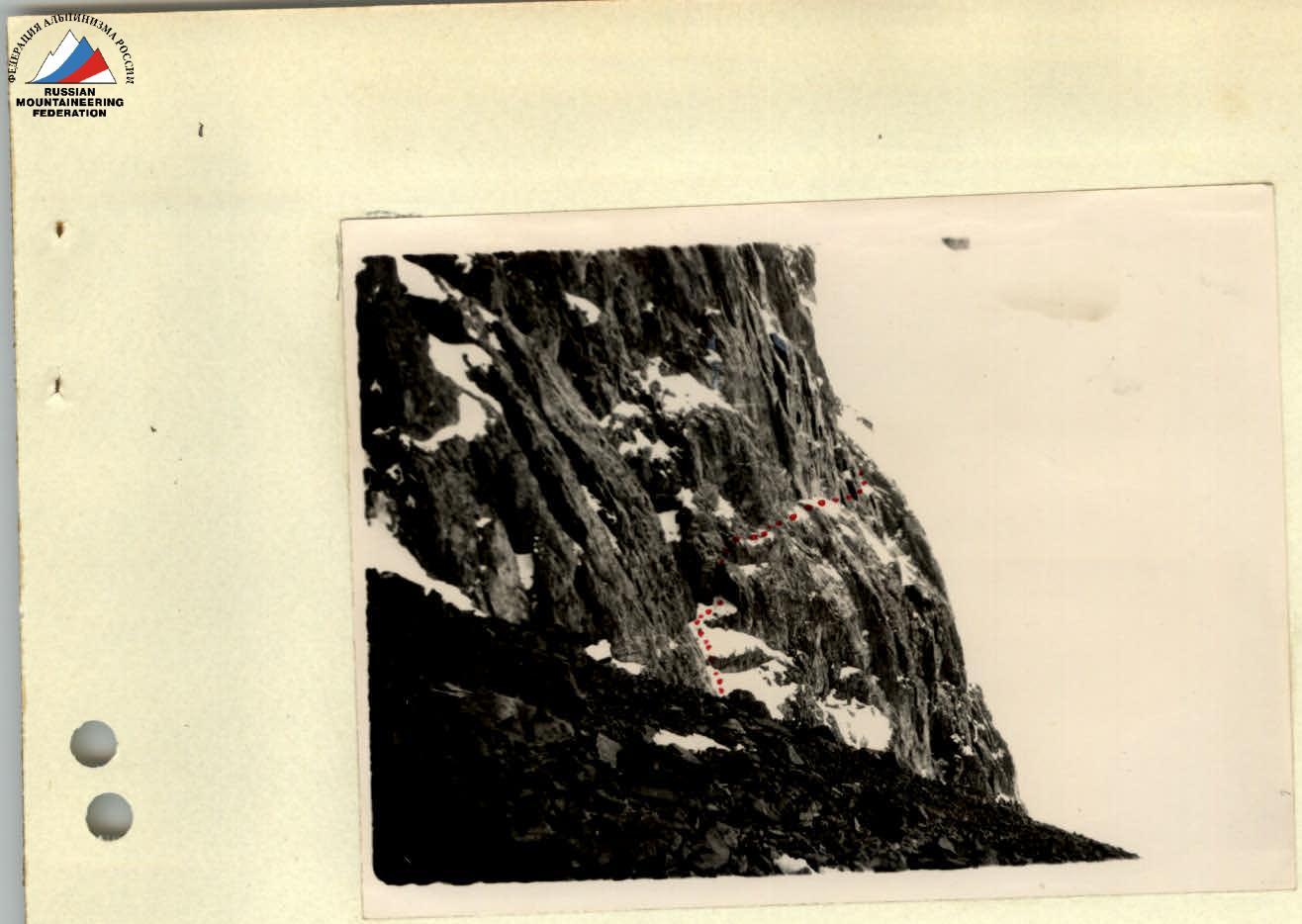 Fig. 1. Start of the route.
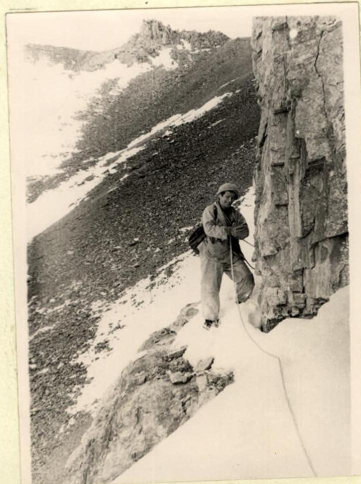 Fig. 2. On the ledge

