Route Description
The peak named after Manshuk Mametova, a glorious daughter of the Kazakh people and a Hero of the Soviet Union, is located in the main ridge of the Maloalmatinsky spur. To the south of it lies the peak Antikainen, and to the north lies the pass of the same name (3750 m).
From the Mynzhilki weather station:
- Cross the Malaya Almatinka river.
- Go around the ancient moraines of the Manshuk Mametova glacier and the western ridge of the Antikainen peak.
- Move along the foot of the ridge, gradually gaining altitude.
- Ascend via the right lateral moraine of the Mayakovsky glacier to the last couloir descending from the southern side of the western ridge of the Antikainen peak.
Ascend the couloir to its fork and continue along the right branch (the rocks are crumbling, be careful!). Then, via the talus on the left side of the couloir, reach the junction of the lateral and main ridges.
Cross the talus and reach the main ridge. The Antikainen peak rises insignificantly above the ridge and is an acute tower with a cairn (tur) on it. The route continues north along the snowy ridge, which leads to a large gendarme with sheer walls.
The gendarme is easily bypassed from the western side via a huge depression. Behind it lies a snow-ice ridge 100–120 m long. Here, one should stay on the western side, as the ridge drops to the east with a wall and cornices, leading to the rocky massif of the Manshuk Mametova peak.
The ascent to the peak is via a couloir:
- Initially, via fine talus
- Then via snow and ice
- Staying on the left side
The 70 m long couloir leads to moderately difficult rocks; move along them to a steep snow patch (be careful!) towards the Manshuk Mametova glacier. When ascending with large groups from the exit from the couloir to the summit, whose massif drops with a 300-meter wall, it is necessary to set up a rope (2 ropes).
After the snow patch, the path continues along the ridge, and 45–50 m later, the summit is reached. The ascent takes 10–11 hours, including 7–8 hours for the climb. Descent is via the same route.
The route was first traversed by instructors from the mountain training school on September 21, 1944, P. Semenov and L. Karapetyan.
Recommendations
- Number of participants: 10–12 people.
- Initial bivouac in the area of the Mynzhilki weather station.
- Departure from the bivouac at 5:00 AM.
- Equipment for a group of 4 people:
- Main rope — 2×30 m
- Rock pitons — 4–5 pieces
- Carabiners — 4 pieces
- Hammers — 2 pieces
 (1)
15 c.t. on the l. side of Mayakovsky
(1)
15 c.t. on the l. side of Mayakovsky 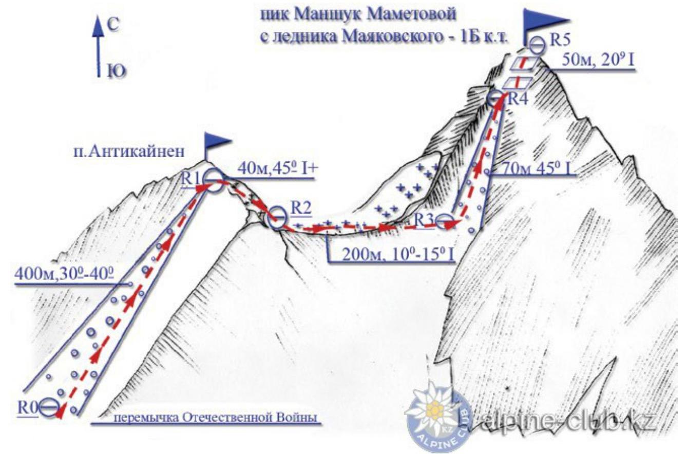
From the Mountain.kz website