97
part of the table
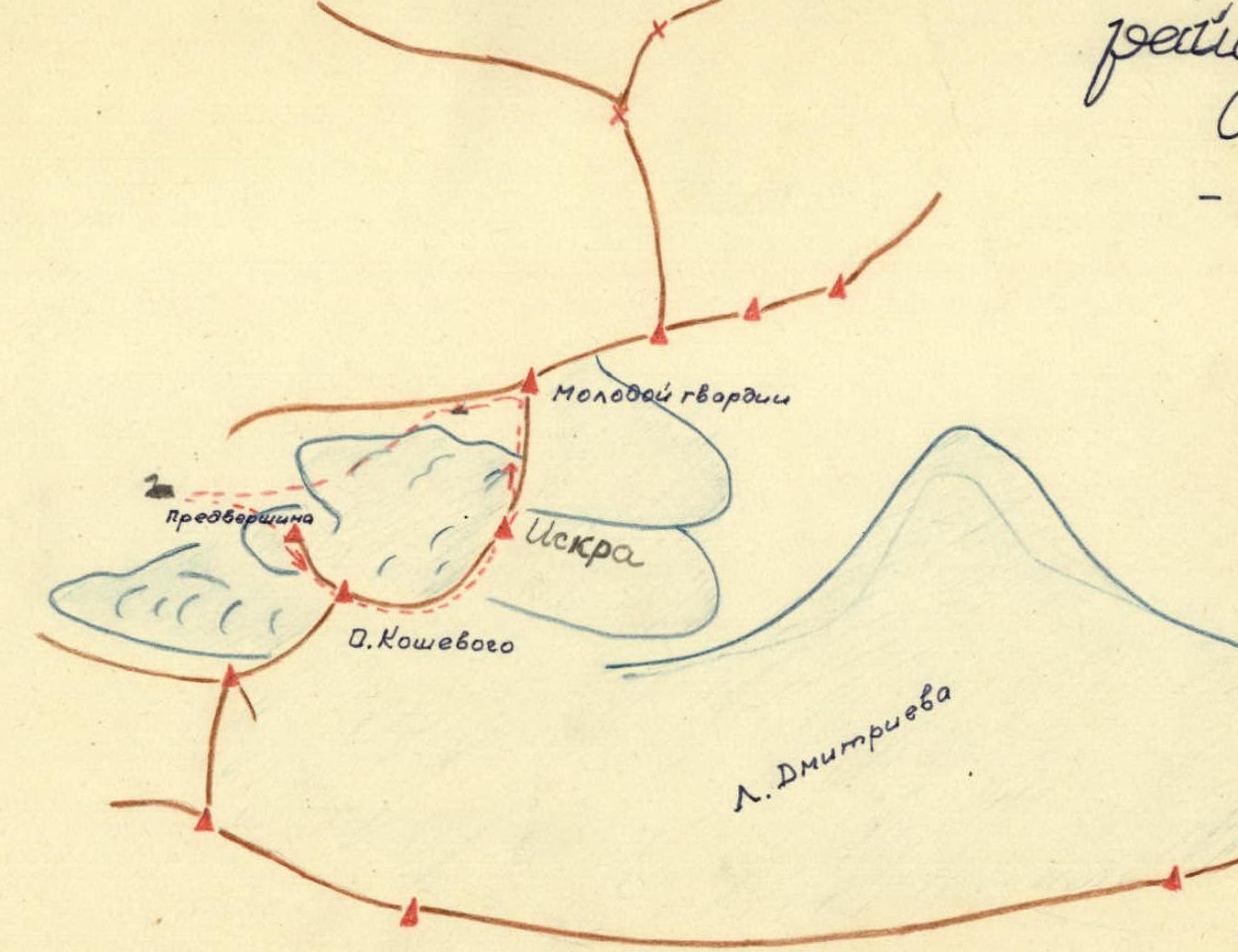
Description of the traverse of the Maloalmatinsky spur section
Through the line: O. Koshevoi — Iskra — Molodaya Gvardiya
The traverse begins with the ascent to the summit of O. Koshevoi. The ascent is made along the western ridge. You can climb in two ways:
- from the west through the couloir (to the right of the western wall as you go);
- along the western wall.
The ascent through the couloir is not difficult, category 1B. The ascent along the western wall of the peak was first made by the mentioned groups of U. Usenov and V. Alekseev in 1954 and classified as category 3B.
While making the traverse of O. Koshevoi — "Iskra" — Molodaya Gvardiya, the group of the Kazakh club started the ascent to the peak Koshevoi along the western wall. The first part of the wall is traversed through a couloir (to the left of the couloir leading to the forepeak). In winter conditions, the couloir is filled with snow. It is more convenient to move along simple rocks with insurance.
The couloir leads to a sheer chimney (8–9 meters), which is overcome by jamming. Behind the chimney is a ledge, and then a "gendarme" rises, which can be bypassed from the north along rocks of medium difficulty.
Having overcome the chimney and bypassed the "gendarme", the group goes to the steep northwestern ridge, along which the further ascent is made. Insurance can be organized here through rock outcrops. In some places, it is possible to move along the passages between the ice and the rocks.
The path along the ridge leads the group to the pre-summit gendarme, crowning the forepeak of O. Koshevoi.
The length of the ascent along the western ridge from the place of exit to the ridge and to the "gendarme" is 3–4 ropes.
The rocky "gendarme" can be overcome either from the north along barely noticeable ledges, or from the west along the wall. The height of the gendarme is about 20 m. From the forepeak, the path goes to the main summit of O. Koshevoi along a simple and gentle ridge.
The most critical sections when ascending to the peak O. Koshevoi from the west and further exit to the northern edge:
- chimney;
- pre-summit "gendarme".
When passing these sections for the organization of reliable insurance, pitons are required.
The descent from the summit to the peak "4300" m is made along a long scree ridge, crowned with cornices (in summer). In winter conditions, the snow is blown away, and the movement is carried out on crampons on ice.
When approaching the rocks of the peak O. Koshevoi:
- you need to move on ice with step cutting (about 60–70 meters of steps). This is the most difficult ice section of the route.
The peak "Iskra" (4300 m) is a 7 rocky towers, which we traverse from south to north. They are somewhat similar to the "needles" of Turksu.
Overcoming towers:
- 1st (large tower) — bypassed on ice on the western side; the rest are overcome "head-on".
- 2nd tower — passed easily, along simple rocks (height 15 m).
- 3rd tower — overcome along the southern wall (rocks of medium difficulty), length 20 m.
- Descent from the "gendarme" is made along destroyed rocks to the north, to the next tower.
- 5th tower — traversed along simple rocks with small walls.
- Next is the ascent to the main tower of the peak. It is necessary to move from the southeast along the ledge with thorough insurance. The length of this section is about 40–45 m.
- Descent to the north on ice — insurance through ice screws.
- 6th tower — from the south it is simple (8–10 m of rock), more difficult is the descent from it to the north on ice. The group used ice screws on this section, as well as on the previous one. The length of the section is 35–40 m. When descending on ice, you can sometimes use rocky outcrops for insurance purposes.
The last challenging section is the path on ice to the north and the isthmus between the peaks "Iskra" and "Molodaya Gvardiya". This section can be bypassed by moving to the left (in the course of travel) into the couloir, and the ice section — on snow. An overnight stay is organized on the isthmus.
On the 4th day, the group of the Kazakh club made a traverse of the peak "Molodaya Gvardiya". The ascent from the south is simple. Movement is hampered by deep snow.
The descent was organized to the west on ice and snow with further exit to the base camp at the foot of the peak O. Koshevoi.
The traverse of "Molodaya Gvardiya" can be assessed as category 2A–2B.
The entire traverse of the peaks O. Koshevoi, "Iskra" and "Molodaya Gvardiya" took two full days (without approaches, from the base camp and to the base camp). In addition, 2 hours 30 minutes – 3 hours were spent on approaches and descent to the city.
This traverse of the three peaks was made for the first time. The climbers believe that in summer conditions this traverse can be assessed as category 4B, and in winter — category 4B. The traverse was made on December 4–7, 1959.
- A. Moryashen
- V. Studenin
- A. Dubadenko
- A. Kovennikov
- A. Kuderin
- A. Noborachek
- A. Khutseza
To the 3rd "gendarme": the second is bypassed on the left along the way along a gentle snowy slope. The 3rd "gendarme" is bypassed along the firn slope (on the left in the course of travel), steepness 55–60°. We descend to the last snowy isthmus before the peak Mira.
The ascent from the isthmus begins with overcoming a 150-meter firn slope with a steepness of 60–70°, further movement along the firn slope without crampons is dangerous, and we went to the middle rocks (50 m, steepness 50–55°), then along the firn on the border with rocks (50 m) we go to the pre-summit middle rocks (30–35 m). The ascent along this path to the peak Mira and descent to the east are classified by M. E. Grudzinsky as category 3A.
Here we found 2 notes of the group of M. E. Grudzinsky, who ascended to the peak Mira in May 1954 from the east along the path of category 2B, and descend to the east to the snowy isthmus.
The descent is simple along the rocks and large scree of the southern slopes of the peak Mira.
The ascent from the isthmus to the peak Gorbunova is simple along a gentle slope covered with small scree.
Having reached the branching of the ridge of the peak named after Gorbunov, we turn north. From here (from the branching of the ridges) the path to the peak Kolpak from the north is clearly visible. The path is easy along a snowy very wide ridge.
The path to the north is relatively easy, along a heavily destroyed rocky ridge, sometimes there are small snowy cornices. "Gendarmes" are easily bypassed both to the right and to the left. Then there are middle strongly destroyed rocks of the ridge. Sometimes the ridge becomes very sharp ("knife-like"), but it is easy to pass with simultaneous insurance. It is only necessary to carefully test all the stones, weakly cemented with snow.
Further there is a 50-meter "gendarme", overcome "head-on" along the middle (20 m) and easy rocks. The pre-summit "gendarme" is bypassed to the right along a not ярко expressed chimney. We go 10–12 meters along complex rocks, and then along easy, heavily destroyed ones, emerging to the summit of Gorbunov.
Here we found a cairn and wrapping paper from a note of the group of M. E. Grudzinsky.
The descent from the summit of Gorbunov is made along a simple ridge with small cornices and "gendarmes", easily passing.
We make the ascent to the next summit (8th in a row) along a heavily destroyed rocky ridge with small "gendarmes". On this section, 2–3-meter sections of complex and middle rocks are occasionally found, which are difficult to pass. Still, the rest of the difficult sections are easily bypassed to the right along the eastern slope.
At the summit, we found a note from the first ascenders — a group of military topographers, who named this summit after 40 years of VLKSM. The cairn is set 30–35 m north of the highest point of the peak (the cairn is a convenient place to work with a theodolite). This is probably why it was moved north.
The descent from the summit "40 years of VLKSM" is not difficult. The ascent to the next summit, standing somewhat apart, and to the last summit does not present any particular technical difficulty. Throughout the section from the peak "40 years of VLKSM", the nature of the route is the same: easy and middle heavily destroyed rocks.
The descent from the last summit is also quite simple — along the middle rocks, and sometimes even along the easy ones. The group believes that the most interesting objects of ascents are:
- Summit No. 1 — ascent from the east and descent to the south towards the pass.
- Ascent to the summit No. 2 from the east and descent either to the north or to the south — to the corresponding isthmuses.
- Traverse of summit No. 4 in any direction (from north to south and from south to north).
- Traverse of summit No. 5 from north to south — the most interesting and difficult route.
- Traverse of the peaks Mira and Gorbunova from north to south with descent to the isthmus between peak Gorbunova and peak "40 years of VLKSM".
It is best to make an ascent to all isthmuses, sticking to the right rocks. Great attention should be paid to the avalanche hazard of the slopes.
We believe that the route should be assessed as category 5A, given the large extent and the presence of numerous difficult sections of rocks, which cannot be passed without thorough piton insurance.
It took four days of painstaking work for our small and mobile group to complete the route.
It is a pity that such a good route is poorly documented. This is because the main part of the route was passed without an experienced photographer.
The description was compiled by:
- V. Studenin (1959)
- A. Vododokhov
Scheme of the area of peaks O. Koshevoi — Molodaya Gvardiya
Scheme of the route of Turova O. Novikova — Sections without interruption!