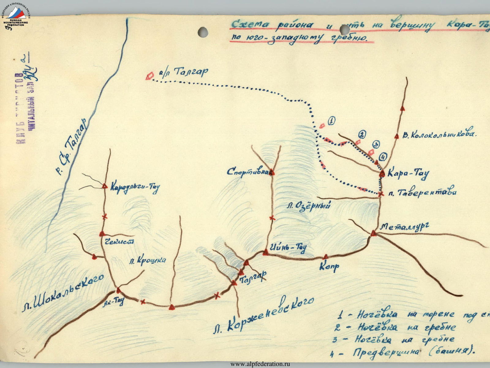
Description of the First Ascent to the summit of Kara-Tau via the Southwest Ridge
Zailiyskiy Ala-Tau range.
Covered in eternal snows, it stretches in a latitudinal direction for over 200 km. In its central part, it takes a direction close to meridional and reaches a height of five kilometers in the powerful Talgar trapezoid.
East of Talgar is the peak Metallurg, whose pyramid rises to 4800 meters; to the southwest is Iyn-Tau, which raises its summit to 4830 meters.
Against this backdrop, all other peaks seem like dwarfs, not representing sporting interest for climbers. But this is not the case.
To the north of Metallurg peak, a spur called Ala-Tas (Motley stones) extends. In this spur, beyond the Taverentava pass, lies the Kara-Tau peak (Black mountain), for which the usual path via the Taverentava pass is not difficult and is classified as category 2A.
From the west, three rocky ridges lead to the Kara-Tau peak, each representing significant sporting interest and considerable difficulty to overcome:
- the first ridge;
- the second ridge;
- the third ridge.
A group of instructors and climbers from the Talgar alpine camp had long been planning to conquer the northernmost ridge, which does not lead directly to the summit but rather 60-70 meters to the left.
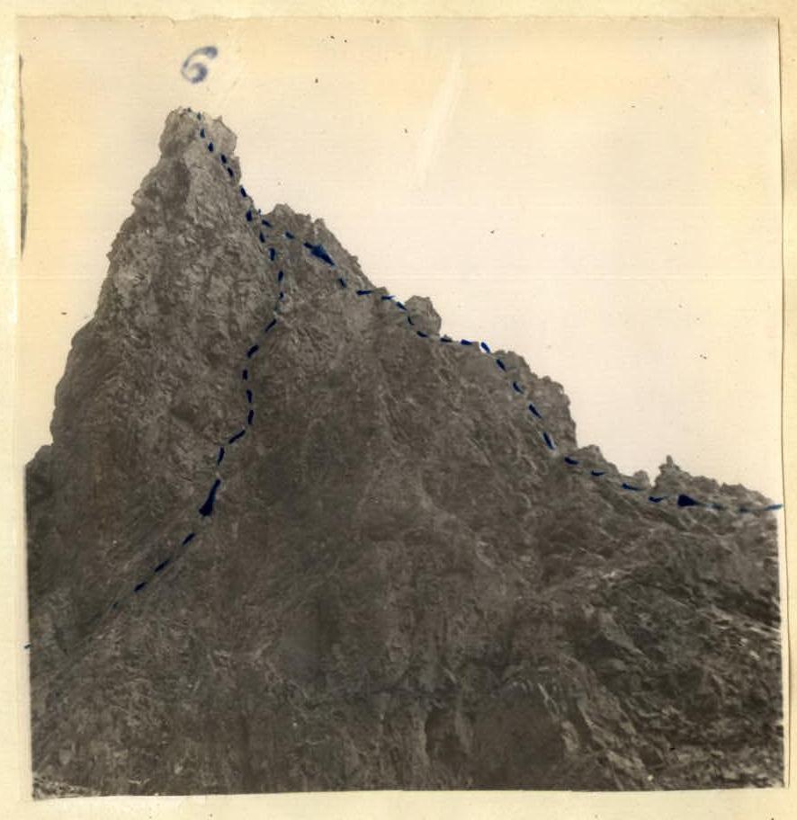
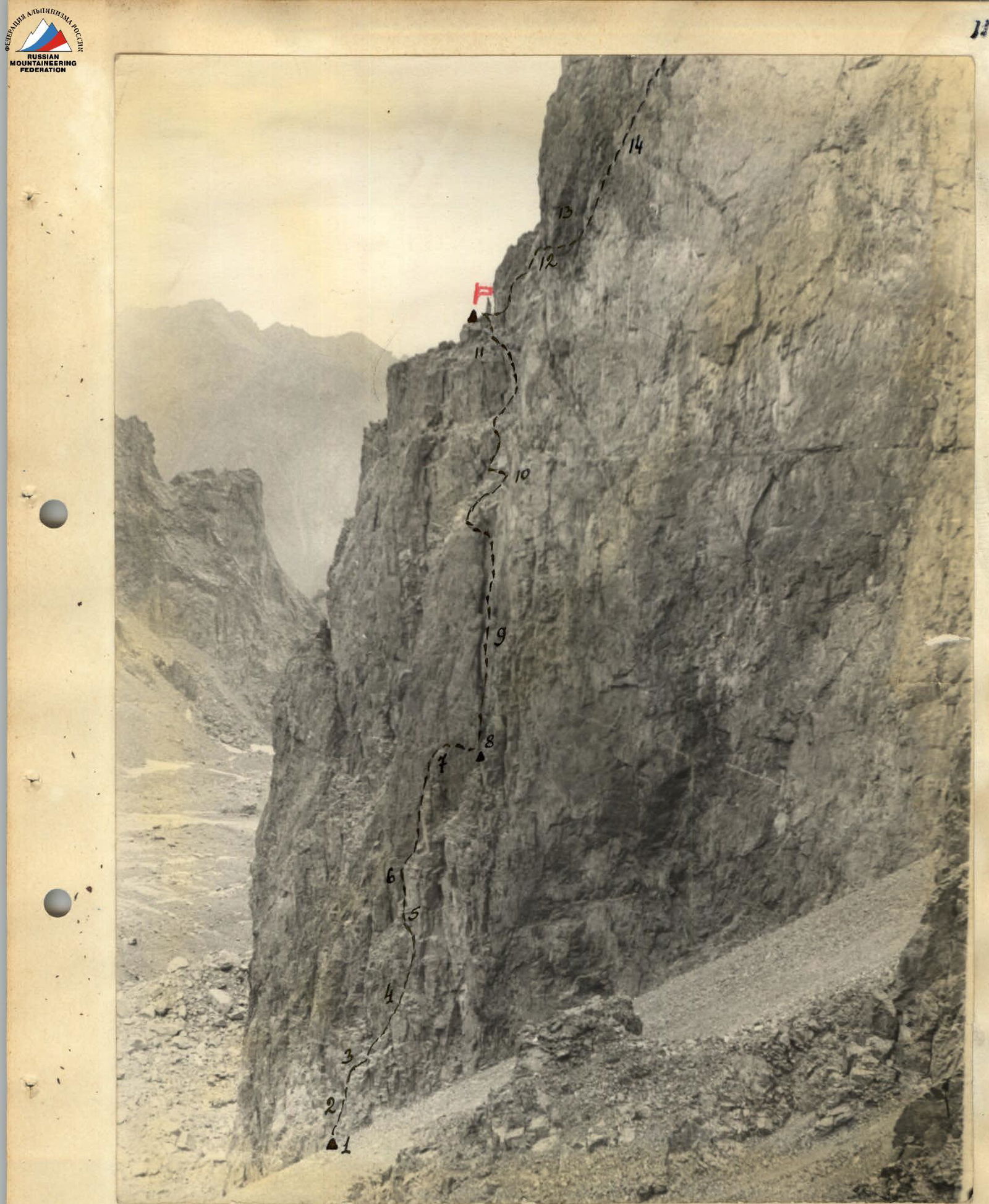
This ridge, in its lower part, drops off with walls and represents a massive monolithic tower of yellow color, divided by two couloirs into three parts. The average steepness of the tower is 75-80°, but most sections are sheer walls (see photo № I and croquis). The total height from the base of the wall to the summit is approximately 750 meters.
Our group decided to ascend the peak via this route in August 1959.
The group composition was as follows:
- Kolchigin Yu.V. - 1st sports category - leader - Alma-Ata
- Reformatsky Yu.D. - 2nd sports category - participant - Moscow
- Zakharikov A.V. - 2nd sports category - participant - Sverdlovsk
- Sogrin S.N. - 2nd sports category - participant - Sverdlovsk
To test our strength, we climbed Sportivnaya peak, from which the entire path to Kara-Tau is clearly visible. We completed this ascent quickly, in 6 hours, while other groups under similar conditions take 10-11 hours.
Then, with the same team, we made a training ascent to the rocky peak of Abay Kunanbaev, category 4B, in difficult meteorological conditions.
After such preliminary training, we considered ourselves ready to tackle the challenging route of Kara-Tau. The weather throughout the season was very unstable, with a large amount of precipitation, but this did not particularly concern us, as snow does not stick to the wall, and one sunny day should clear the wall completely.
On August 22, 1959, we left the camp to make the first ascent.
The path from the camp goes along a well-defined trail to the east towards the training rocks, then turns south and, along the right (orographic) lateral moraine of the Ozerny glacier, leads to the foot of the wall in 3-3.5 hours.
After carefully examining all ascent options once again, we decided to start the ascent not directly along the ridge, as it is constantly exposed to falling rocks, but along the safer southern section of the wall, with an exit to the ridge in its middle part.
In the morning, as we began our ascent up the wall and had processed about 40 meters, we were called back to the camp via radio to participate in rescue work.
Although it was very disappointing to abandon everything at the start, we returned to the camp.
All equipment and food supplies were left at the foot of the wall.
On August 27, 1959. Three days later, having obtained additional equipment, food, and an extended time limit, we ascended again to the campsite.
Our group had the following equipment:
- Main rope - 30 m - 2 pieces
- Auxiliary rope - 40 m - 1 piece
- Abalakov belts - 4 pieces
- Auxiliary loops - 3 m - 4 pieces
- 3-step ladder - 1 piece
- Carabiners - 14 pieces
- Rock pitons - 25 pieces
- Rock hammers - 2 pieces
- Ice pitons - 2 pieces
The rest of the equipment was standard for all groups.
On August 28, the weather was wonderful. It was perhaps the first day all summer when the horizon was completely free of clouds. The mood among all participants was cheerful, and everyone's physical condition was excellent.
After distributing all the equipment into three backpacks so that the lead climber could move freely, the first rope team (Kolchigin - Zakharikov) began to move forward.
It was 8:00. The start of the path goes along a steep (85°) inner corner, 30-35 meters long. The section is complex. We had to wear rubber shoes, which significantly facilitated movement (Kolchigin and Sogrin wore shoes almost to the very summit).
The upper part of the inner corner leads to a shelf that can accommodate two people at once. From the shelf, movement begins directly "head-on" along a sheer section of the wall, with no detours to the left or right. With great difficulty, Kolchigin managed to make his way up on one rope, hammering in six pitons in the process. After pulling up the backpacks and receiving Zakharikov, Kolchigin continued the ascent and approached R5.
R5 is one of the most challenging spots on the first day. The six-meter sheer wall is very smooth and lacks cracks. Moreover, a cornice overhangs the top. There is nowhere to organize protection, so one must move very cautiously, almost on fingertips.
After spending 2 hours overcoming this section, the group approached a crevice about 10 meters long.
If the rocks before this crevice were monolithic and pleasant to climb, the crevice contained "live" stones, and we had to move with extreme caution to avoid dislodging rocks onto our companions. To the right of the crevice, there is a narrow ledge where we could all gather.
Above the ledge begins a chimney (70 m) with several plugs. There are many cracks in the chimney, so protection can be organized almost anywhere. Despite the significant steepness (85-90°), moving through the chimney is a true pleasure because the rocks are dense, not fragmented, and the width of the chimney allows for jamming and self-protection. The only inconvenience was pulling up the backpacks; with a backpack, it's impossible to pass through the chimney. At 16:00, we reached the upper plug, and at that time, a group of climbers was descending from the Taverentava pass, with whom we established contact.
Wishing us a successful journey, they began their descent, and we continued our ascent.
Above the chimney, the wall becomes less steep and transitions into rocks of medium difficulty, but due to their fragmented nature, they significantly slow down progress.
Throughout the day, we didn't even have a sip of water. Thirst tormented us. We felt not only physical but also mental fatigue. A rock accidentally dislodged would reach the glacier without even touching the rocks.
Finally, at 18:00, we reached a narrow ledge where we could organize a sitting bivouac. Sogrin and Reformatsky stayed to set up the bivouac, while Kolchigin and Zakharikov decided to prepare the path for the next morning and moved further towards the ridge, which they reached in about 30-40 minutes.
And here, as in a fairy tale, a wonderful view unfolded.
- To the north - an expansive valley with green gardens and yellow fields.
- To the south - the beautiful Talgar.
- Below - sheer rocks.
- Above - sheer walls.
- On the section of the ridge we reached - a platform, as if specifically created for setting up a tent, on which lay pieces of snow that hadn't melted.
After Sogrin and Reformatsky joined us, we all gathered on the platform at 19:00.
First, we melted snow and drank, then set up the tent and contacted the group below via radio.
This platform allowed us to rest well, instilled confidence in us, and, as it were, gave us new strength for further struggle towards the summit.
On the first day, we hammered in 24 pitons (not counting those used for hanging the backpacks) and ascended 250-270 meters vertically. The entire path took 11 hours.
August 29, 1959. We began the ascent immediately from the bivouac site, moving vertically up along inclined slabs with few handholds. After 20 meters, a rocky couloir began, with a steepness of up to 70°, where even in the morning, rocks are dislodged.
We decided to traverse to the right and exit onto the right ridge of the tower, which, although technically challenging, was safer.
The ledge we started traversing along was no more than 1 meter wide, and in some places, only 20-40 centimeters. The length of the ledge was 35-40 meters. About 8 meters required crawling on our bellies because a cornice overhung the ledge. Pitons had to be hammered either into the upper or lower parts of the rocks.
Backpacks had to be moved by dragging. After 1 hour and 30 minutes, the ledge led into a steep couloir, relatively simple in its lower part but closed off by sheer rocks 40 meters up. Through a crevice veering to the right, we exited the couloir onto the ridge.
On the ridge, we all gathered (on a small ledge), had breakfast, and examined all route options.
It seemed to us that the most straightforward, clear, and logical path should go along the ridge, which averaged 70° in steepness, with sheer sections in places.
We rested, then began moving upwards. Kolchigin, having ascended 6-7 meters, was unable to advance another meter for 1 hour and 30 minutes because detours were out of the question, and the ascent along the ridge was extremely challenging.
Only after hammering in 4 petal pitons and using them as handholds did the lead climber manage to ascend and organize protection.
Further along the ridge, the rocks were difficult, requiring mandatory piton placement, but the path was clear - straight up the ridge.
We moved until R17 for 6 hours and approached a wide, inclined chimney (60-70°), which, after the difficult rocks, seemed an easy task.
Above the chimney, rocks of medium difficulty begin; the steepness is 70°. Within 1 hour, we reached a small inclined platform where we organized a bivouac, not as comfortable as before but still suitable for a good rest lying down.
August 30, 1959. We set out at 6:00. The first 100 meters were moved alternately, and then from R18, we could switch to simultaneous movement. By 8:30, we were at the highest point of the tower. From the tower to the Kara-Tau summit leads a heavily serrated short ridge, on which eight gendarmes are located.
To the south, the ridge drops off with walls, and to the north - with steep (60°) slopes of a combined (snow, rocks) nature. Therefore, all gendarmes are overcome directly "head-on," except for the 7th and 8th, where a detour to the left (by the route) is possible.
Overcoming all gendarmes took 4 hours. After overcoming the VIII gendarme, we reached the slope of Kara-Tau and, 20 minutes later, via easy and medium rocks, reached the summit of Kara-Tau at 12:00.
Despite deteriorating weather and fatigue, our mood was excellent, and we rested on the summit for 30 minutes. We began our descent along the familiar easy path to Taverentava peak, then to Ozerny lake, from where, with a sense of justified pride, we once again examined "our" wall.
By lunchtime, we arrived at the camp.
Conclusion
The ascent to Kara-Tau peak represents a very interesting rocky route, featuring almost all forms and elements of rocky relief.
It is advisable to undertake it with a small group (no more than four people).
In bad weather, the ascent is obviously impossible because:
- some sections of the route are impassable in gloves and climbing boots;
- there are no detours.
We spent 27 working hours on the entire route, during which 52 rock pitons were hammered (6 of which were left on the route). 8 control cairns were built, the locations of which are marked on the photograph and croquis of the path.
We consider the difficulty of the route to be category 5A.
Croquis and photographs were made by participant Sogrin. The description was compiled by the group leader Yu. Kolchigin.
 Map of the area and path to Kara-Tau peak via the southwest ridge.
- Bivouac on the moraine under the wall.
- Bivouac on the ridge.
- Bivouac on the ridge.
- Sub-summit (tower).
 Lower part of the wall.
▲ — Control cairns.
P — Bivouac.
Lower part of the wall.
▲ — Control cairns.
P — Bivouac.
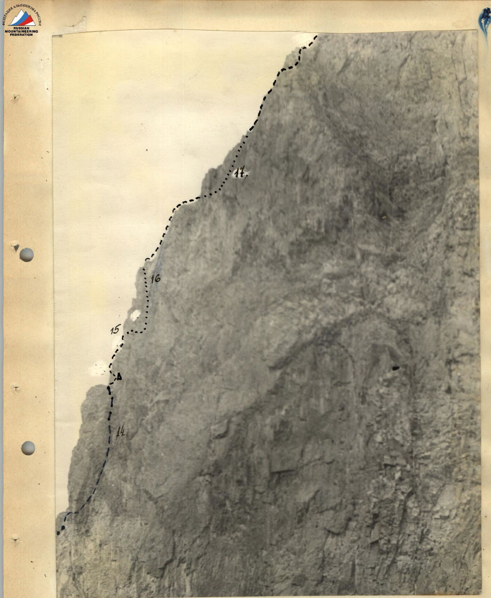
 Middle part of the wall.
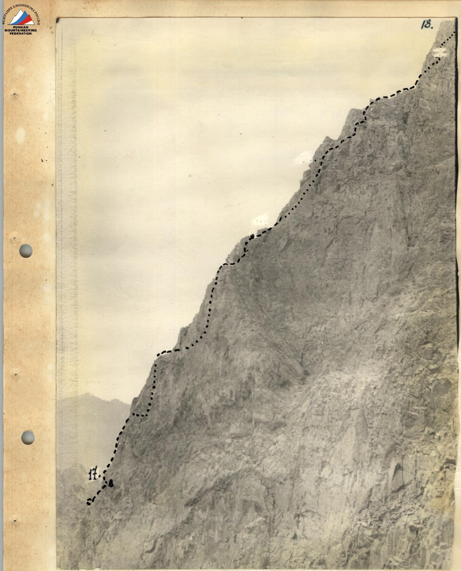
 Upper part of the wall.
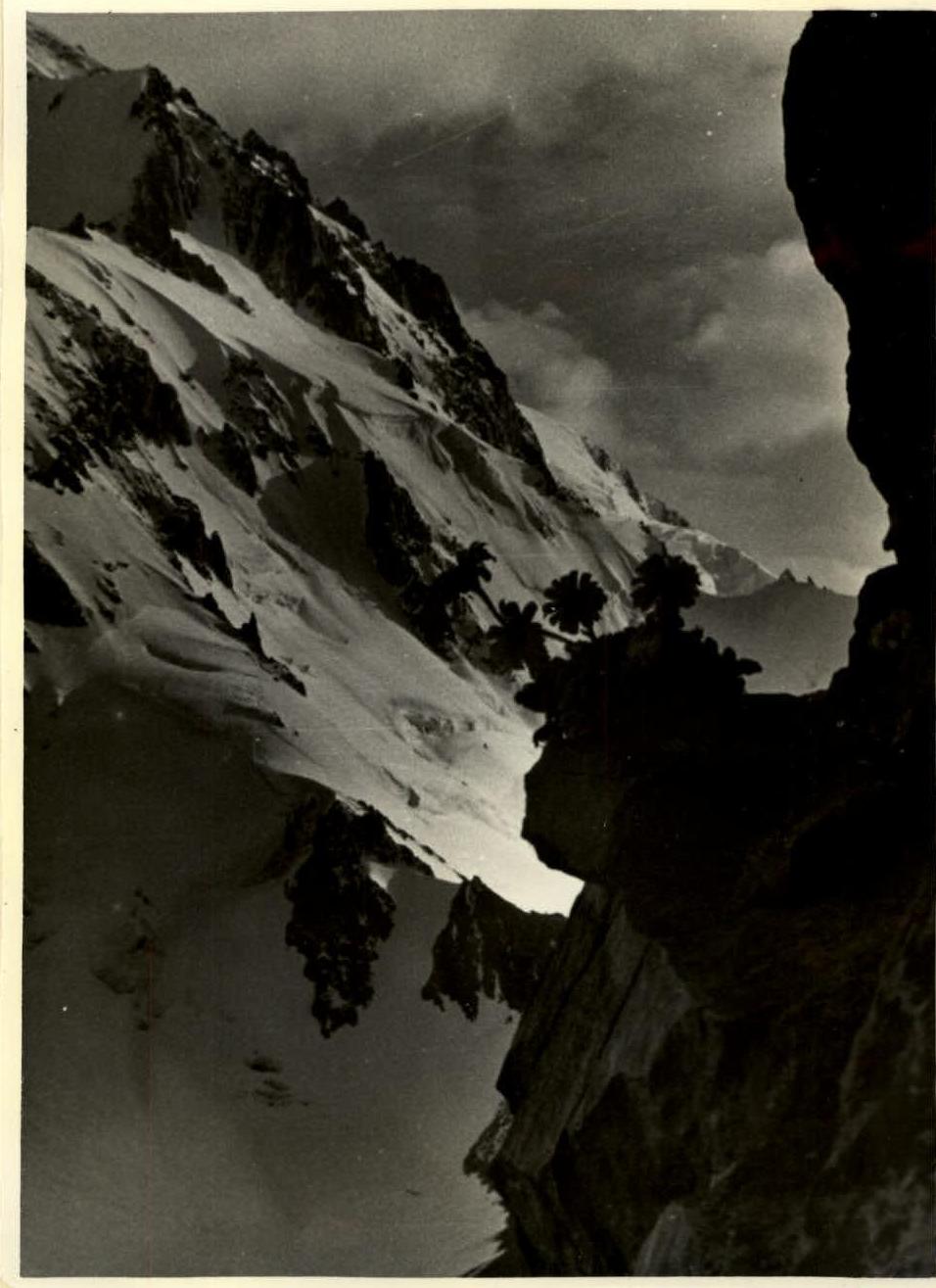
 Mountain daisy on rocks. To the right - the wall of Kara-Tau peak. To the left - Iyn-Tau peak and the slope of Kopr peak.
 "Gendarme" № 1.
 "Gendarme" № 6.