DESCRIPTION
7.2.54
Traversing peak "Zharsay" with ascent via the north-eastern ridge from Zharsay glacier and descent via the north-western ridge
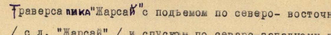 to "Bezymyannyy" pass.
The "Zharsay" peak is located in the main ridge of Trans-Ili Alatau in the south-eastern direction from the "Metallurg" peak. The height of the peak is 4750 m (rao No. 1).
Day 1
The path from "Talgar" camp goes along a steep grassy slope to the east to the training rocks. Further, crossing the moraine of "Ozerny" glacier, we exit to its right (orographic) part, and the movement goes up along a clearly marked trail to a wide couloir (with reddish rock) descending from "Kolokolnikov" peak. At this point, we turn to the right and exit to "Ozerny" glacier and, moving along its middle part, approach the foot of "Taverentaau" pass.
Time from the camp to the foot of the pass is 3.5–4 hours.
The ascent to the pass goes along a wide, steep couloir covered with small and medium talus. In the middle and upper part of the couloir, the talus is partially covered with snow. The group used snowfields for the ascent.
The ascent to the pass takes 2–2.5 hours. On the pass, the group left a note, the pass category is 2A.
The descent from the pass goes with traversing to the left of the snow-ice slope, with a steepness of 20–25°, and, having reached the rocky ridge extending from "Karatay" peak, the descent goes along a gentle snow slope, going to the right under the steep slope of "Taverentaau" pass.
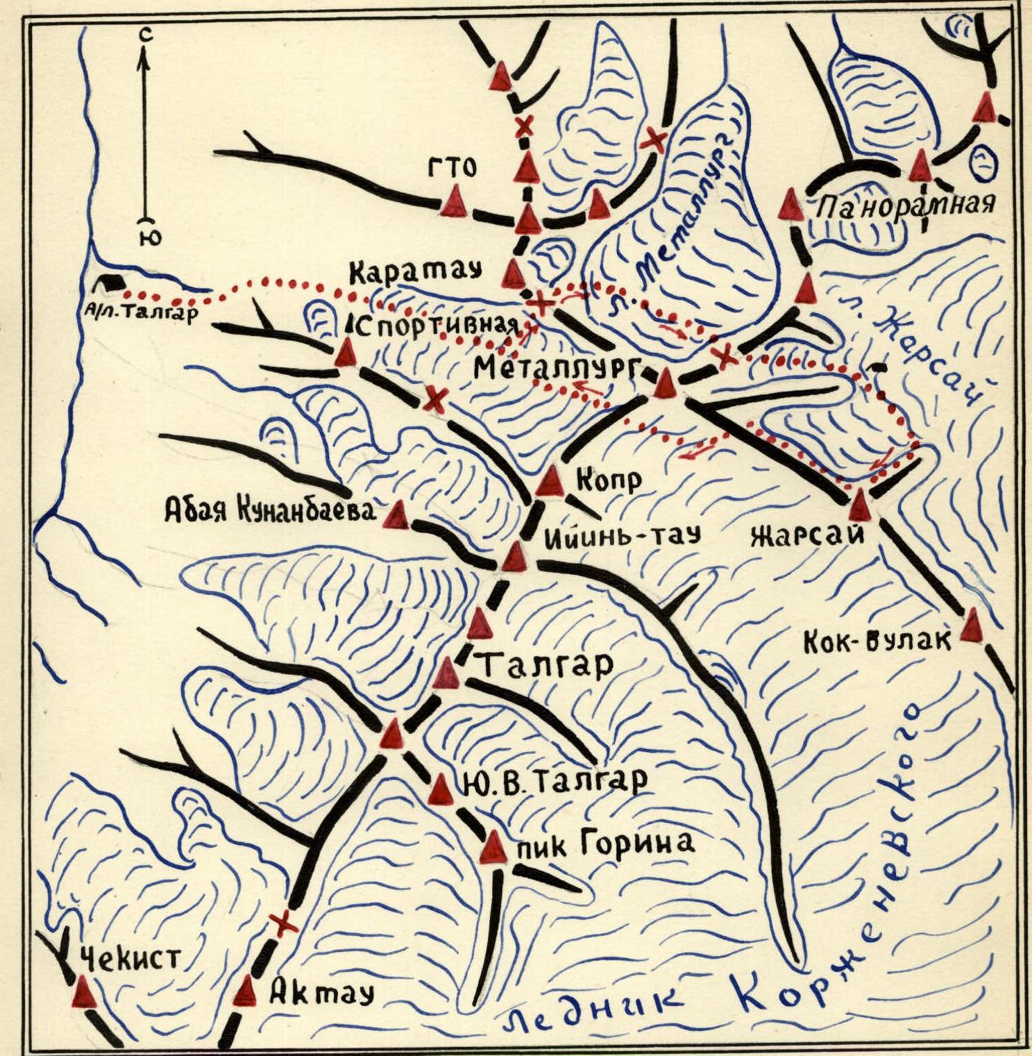 Fig. 1. Scheme of the route to Zharsay peak.
Having descended along the above-mentioned slope, we exit to the middle talus lying on the rocky outcrops. Further, the path goes along rocks of medium difficulty, 30 m long. During the descent, the group натянула перила (used rope protection). After descending along the rocks, exiting to the small talus, in the lower part covered with snow, we exit to the "Metallurg" glacier circus. The descent from the pass takes 1–1.5 hours.
The further path goes along "Metallurg" glacier to the clearly marked saddle of the north-eastern ridge of "Metallurg" peak.
When crossing "Metallurg" glacier, one should stick to its left part, paying attention to the upper ice falls of "Metallurg" peak. Movement along the glacier is in rope teams. After an hour's journey along the glacier, we approach the foot of the saddle. The ascent to the saddle goes along a snow-ice slope with a steepness of up to 35°.
In the middle part of the slope, it is advisable to exit to the right destroyed rocky outcrops and, having passed along them 50–60 m, exit along the snow-ice slope to the saddle. The descent from the saddle goes along the large talus to the circus of the south-western branch of "Zharsay" glacier. A cairn is left on the saddle.
Further movement goes along the flat part of the glacier down with a detour around the lateral ridge extending from the main ridge. Having bypassed the spur, we exit to the southern branch of "Zharsay" glacier and on the slope of the destroyed ridge we organize an overnight stay. From the overnight site, the north-eastern ridge of "Zharsay" peak is clearly visible (the path of movement).
Time from the camp to the overnight stay is 12–14 hours.
Day 2
From the overnight site, the path goes with a descent to "Zharsay" glacier and, crossing it in a south-eastern direction, we approach the foot of the wide couloir of the north-eastern ridge (the beginning of the traverse). Time is 30 minutes.
At first, the ascent goes along a snow slope, with a steepness of 30–45° in the direction of the 1st rocky island. From here, the movement goes to the upper exposed part of the 1st rocky ridge. From the rocky ridge, the steepness of the slope increases sharply to 45–50°, and the snow turns into ice. Movement along the slope is on crampons with piton protection.
In this section, the group hammered 6 intermediate ice pitons. Having overcome the ice couloir, we exit to the snow ridge leading to the 1st big gendarme of the ridge. Time from the overnight stay to the 1st gendarme is 2–2.5 hours.
At the foot of the 1st gendarme, the group left the first control cairn with a note. The first gendarme is very difficult to bypass on the right, the group bypassed it on the left along wide rocky ledges, using protection through ledges. Having bypassed the 1st gendarme, one should not ascend to the upper part of the ridge, but should move along the rocks, bypassing the 2nd gendarme. Throughout the entire length of the bypass of the two gendarmes - rocks of medium difficulty, having good ledges, holds. Having bypassed the two gendarmes, we approach a steep narrow couloir, throughout its entire length covered with flow ice (photo No. 4). The length of the couloir is 35 m, steepness is 60–70°.
The couloir leads to the ridge. Due to the fact that the couloir is very steep and dangerous in its upper part, one should exit along the left vertical wall to a horizontal ledge in its middle part.
The wall is smooth, has few holds. The first climber overcame this section without a backpack. The length of the wall is 25 m. In the couloir and on the wall, 6 rock pitons were hammered for protection.
Having overcome the wall and exited to the horizontal ledge, ropes were натянуты (pulled) through a rock piton, then backpacks were lifted, and subsequent team members overcame this section along the ropes with top protection.
Further, the path goes along easy rocks to a small snow ridge, moving along which, we approach the next small gendarme. The gendarme is bypassed on the left along ledges. The rocks of this gendarme are difficult, but have a sufficient number of firm holds. We exit to the gendarme and further to the rocky ridge leading to the big fifth gendarme. The ridge is narrow, having a cornice on the left. It is passed with alternate protection through an ice axe. The length of the ridge is 80–100 m.
On the left, the fifth gendarme is a sheer wall, on the right - an ice slope with a steepness of 80–85°. Therefore, the gendarme is passed "head-on" along the inner corner, with a steepness of about 70° and a height of 30 m. Then - along smooth inclined slabs with a steepness of 35–40° and the upper part - along simple, but very destroyed rocks. On this gendarme, the group hammered 5 rock pitons.
Having passed this gendarme, we exit to the ridge leading to the sixth gendarme, before which we organize an overnight stay on a site of destroyed rocks.
The described path requires 12–13 hours of intense work. From the overnight site, the path goes along a gentle snow ridge to the sixth gendarme, which cannot be bypassed: on the right - an ice slope with a steepness of 80–85°, on the left - sheer rocks. The gendarme is passed "head-on". The path goes along a crack, with a steepness of 65–70° and a length of 25 m, which leads to inclined slabs with a steepness of 35–40°.
Having exited to them, we pass along the inner corner (length 7–8 m, steepness 80–85°). On the left - sheer rocks.
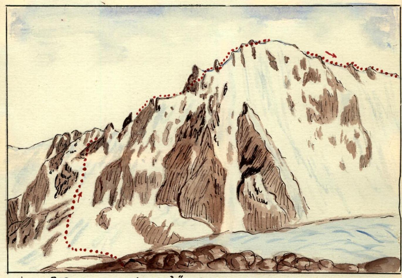 View of "Zharsay" peak from the eponymous glacier. The path of the traverse along the north-eastern ridge.
The gendarme is passed "head-on". The path goes along a crack with a steepness of 65–70° and a length of 25 m, which leads to inclined slabs with a steepness of 35–40°.
Having exited to them, we pass along the inner corner (length 7–8 m, steepness 75°), ending with a large plug, under which we exit to the right to a rocky wall, with a height of 8–10 m, steepness of 85–90°. Here, 4 rock pitons were hammered.
Having overcome this gendarme, we exit to the foot of an ice slope, with a steepness of 55–60° and a length of 45–50 m. The movement requires cutting steps (about forty) and piton protection, where the group hammered three ice pitons.
Having overcome this slope, we exit to a snow ridge leading to the seventh gendarme. This is a rocky ascent with a height of 12–15 m, steepness of up to 70°. Bypassing the gendarme is impossible, so it is overcome "head-on" with the use of piton protection (2 pitons).
Further along the snow ridge, we approach the eighth and ninth gendarmes, which do not present any difficulty and are overcome with alternate protection through ledges.
Further, the path goes along a snow ridge with rare rocky outcrops, leading to the summit ascent.
The exit to the summit is a destroyed rocks with a steepness of 70° and a length of 25–30 m, covered with flow ice and powdered with snow. The exit is made on a full rope with bottom protection through a ledge, since it is impossible to organize protection on the ascent.
The entire path from the overnight site to the summit took 6 hours. "Zharsay" peak is a rocky jumble.
The further path of the traverse goes along the north-western ridge. The ridge is snow-rocky. Movement along it requires simultaneous protection. Along it, we exit to the first gendarme.
This gendarme is passed straight down and requires alternate protection through ledges.
The second gendarme is a monolithic rocky step. The descent from it is made by the method of "sitting on a rope", on 3 ropes.
The third gendarme is bypassed on the left along rocks covered with perpetual ice and snow. The next two gendarmes are rocks of medium difficulty, which are overcome with alternate protection through ledges.
The further path goes along a snow-rocky ridge to "Bezymyannyy" pass, where the group left a note.
From "Bezymyannyy" pass, along "Korzhenevskogo" glacier, the path goes to the saddle between "Metallurg" and "Kopr" peaks. The saddle is passed for the first time and named by us "Kopr" pass. It is assessed as category 3B.
From the eastern side, the pass is a gentle snow slope, and from the western side - a long ice slope with very steep ascents.
Overcoming this slope requires careful piton protection. The length of the slope is almost 1000 m. The slope can be divided into two sections of approximately equal length. Both parts are passed, sticking to the rocks on the right. The section in the middle part of the slope is overcome along the left slope, reaching 60° steepness.
The entire path from the summit to the right lateral moraine of "Ozerny" glacier takes 8 hours.
From the right lateral moraine of "Ozerny" glacier to the camp, the group descended in 1.5 hours.
The present traverse is assessed by the group as a 5A category route.
Group leader - Master of Sports P. Shumikhin. The original is true: Щrudchinieniy.


