Ascent Passport
-
Ascent class: rock.
-
Ascent area, ridge: North Tien Shan, Trans-Ili Alatau.
-
Peak, its height, ascent route: p. Geroyev Panfilovtsev, 4020 m, via the western ridge.
-
Proposed difficulty category: 2B.
-
Route characteristics: height difference 165 m; route length — 480 m; sections 5–6 cat. diff. are absent; average steepness — 20°.
-
Pitons hammered for belay: rock — 3, ice and bolt pitons were not used.
-
Number of travel hours: 4 h 40 min.
-
Number of overnight stays and their characteristics: there are no overnight stays on the route.
-
Surname, name, patronymic of the leader, participants and their qualifications:
Leader: Babichev V. — Pr. Participants:
- Fidchenko T.V. — Pr.
- Tretyakov A.V. — Pr.
- Kumashev M.S. — Shr.
- Posokhov S. — Shr.
- Bryakin S.V. — Shr.
- Team coach: MSMK Popenko Yu.S.
- Date of departure on the route and return: February 10, 1979.
2. Area Map
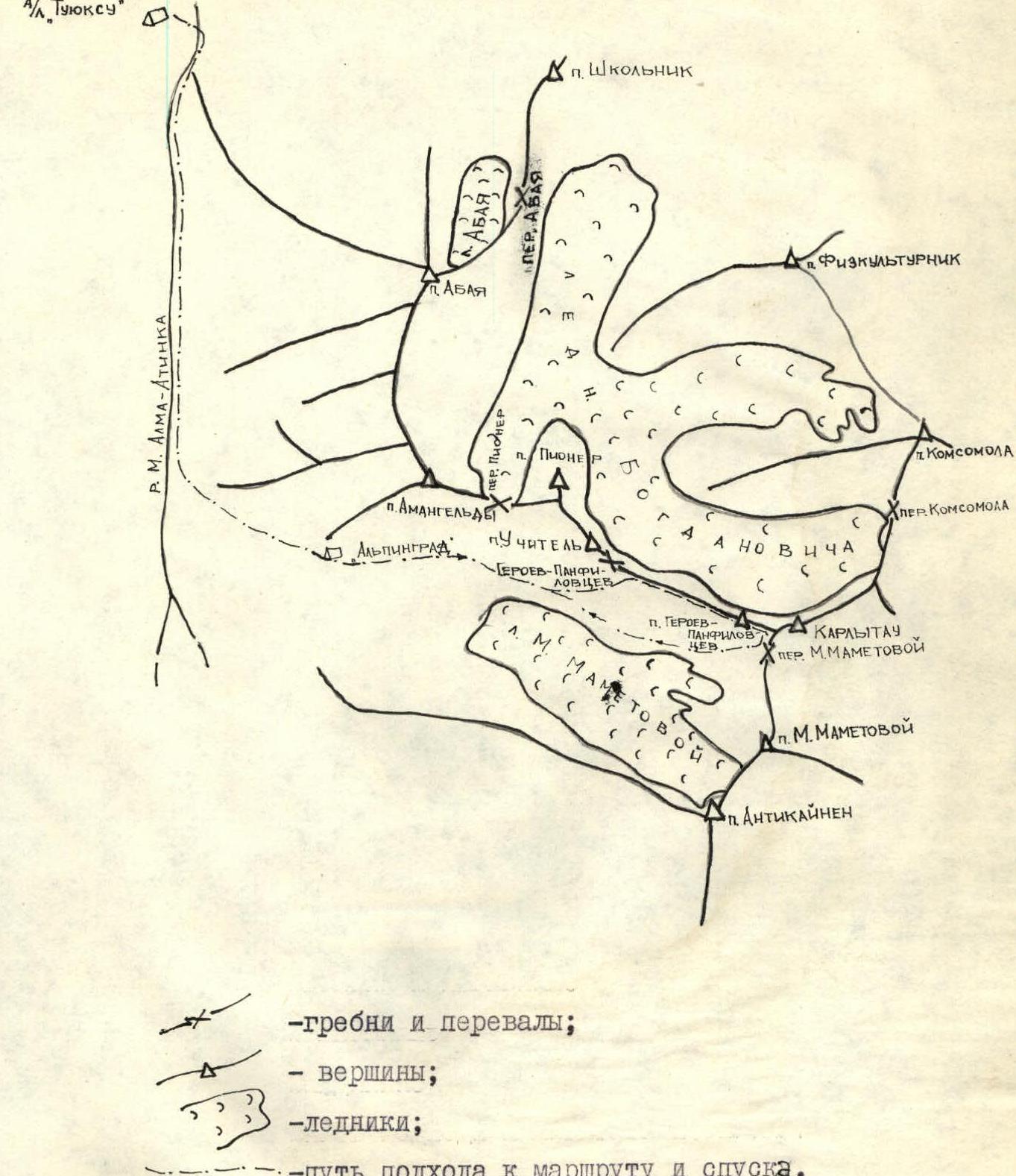 — ridges and passes;
- — peaks;
— glaciers;
- — path to the route and descent.
3. Brief description of the approach to the route and descent
From the Tuyuk-Su base, move along the road up the Malaya Alma-Atinka river gorge to the Mynzhilki tract (1 h), then along the trail ascend to the terminal moraine of the M. Mametova glacier (first on the way, orographically to the right). The ascent to it — to the "Alpinograd" campsite — takes 40–50 min.
From the "Alpinograd" campsite, go along the right (orogr.) lateral moraine of the M. Mametova glacier. Having passed under the southwestern walls of p. Uchitel, at the end of the moraine, cross over to the scree, along which ascend to the ridge between the Uchitel and Geroyev Panfilovtsev peaks (see Map and photo No. 1). Then move along the wide, hilly ridge towards the peak to the beginning of the route (see photo R1). Descent from the peak is made along the wide snowy ridge to the east, and then along the scree hilly ridge to the south, to the M. Mametova pass. From the pass, descend along the scree to the right lateral moraine of the M. Mametova glacier (see diagram and photo No. 1).
4. Table of main characteristics of the ascent route
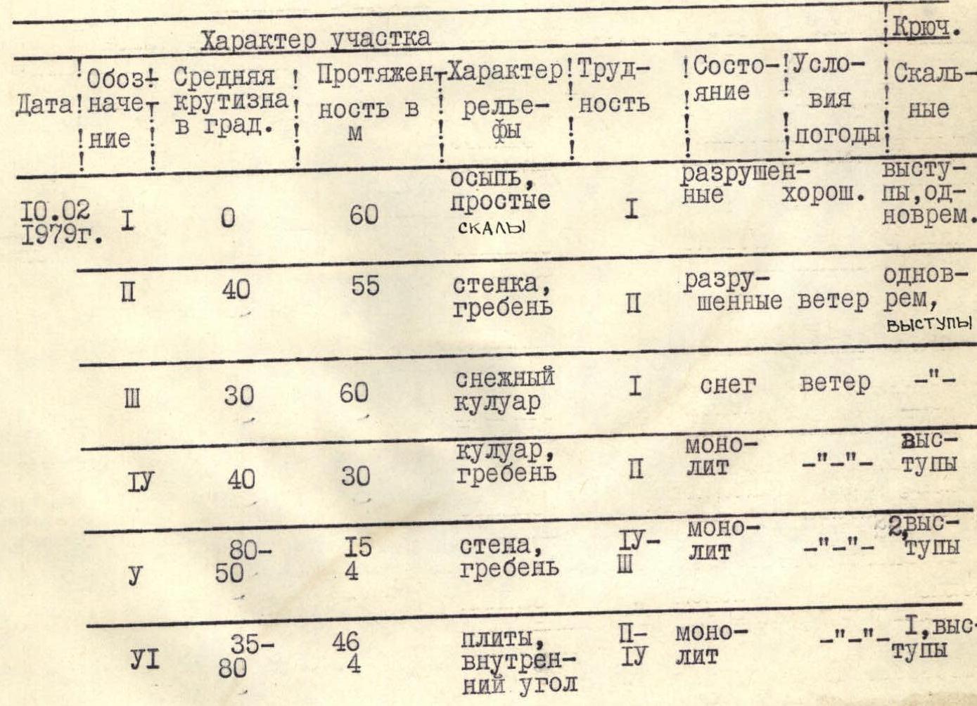 Continuation of the table.
| Designation (start date) | Average steepness (in degrees) | Length (m) | Nature of relief | Difficulty | Condition | Weather conditions | Rock pitons |
|---|---|---|---|---|---|---|---|
| R1 (February 10, 1979) | 0 | 60 m | scree, simple rocks | I | destroyed | good | ledges, simultaneous |
| R2 | 40 | 55 m | wall, ridge | II | destroyed | wind | simultaneous, ledges |
| R3 | 30 | 60 m | snowy couloir | I | snow | wind | — |
| R4 | 40 | 30 m | couloir, ridge | III | monolith | — | ledges |
| R5 | 50–80 | 15–4 m | wall, ridge | IV | monolith | — | 2 ledges |
| R6 | 40–45 | 46 m | slabs, inner corner | II–IV | monolith | — | 1, ledges |
| R7 | 40 | 40 m | couloir | II | destroyed | wind | ledges |
| R8 | 15 | 160–200 m | scree, ridge | I | — | — | simultaneous |
5. Explanation to the table
The route begins with a small ascent on the ridge (point 0).
Section R1. The first group of gendarmes is bypassed on the right along the scree and light destroyed rocks with simultaneous movement, belay through ledges.
Section R2. Exit to the ridge along the destroyed wall, possible rockfall. Then to the right along the narrow slabby ridge (ledges) to a small site. From it, descend 30–35 m into the hollow along rocks of medium difficulty, belay through ledges.
Section R3. Move up along the wide snowy couloir with a steepness of 20–30° in the direction of a vaguely expressed couloir composed of black rocks.
Section R4. Along the couloir composed of black rocks of medium difficulty, ascend to a site on the ridge. Movement is alternating, belay through ledges.
In the upper part of the site, in a niche under a gendarme, there is a control cairn (see photo 2).
Section R5. The key section of the route — bypassing the gendarme on the left, first along a narrow ledge, then to the left — up along the difficult rocks of a steep wall. Exit from the wall to a narrow slabby ridge (see photo 3), along which descend 4–5 m to a saddle. For the rest of the participants, a rope belay is organized.
Section R6. From a small ledge along slabs with a steepness of 40–45°, move to the right — up (along ledges) to a ledge under the base of a 4-meter sheer inner corner composed of difficult smooth rocks without holds. The inner corner is climbed with piton belay and leads to the base of a rocky couloir. For the group participants, a rope belay is organized.
Section R7. Along the couloir composed of destroyed rocks of medium difficulty (belay through ledges), ascend to the scree at the base of the tower of the pre-summit ridge.
Section R8. Moving simultaneously, bypassing the tower on the right along the scree, ascend to the pre-summit ridge. Along it, 10–15 min of walking to the summit.
Group leader: Babichev V.

