Ascent Log.
- Ascent class — technical.
- Ascent area — Trans-Ili Alatau, Tian Shan.
- Ascent route — Peak Amangeldy, 4100 m from the north.
- Estimated difficulty category — 4A.
- Ascent characteristics:
- Elevation gain — 500 m.
- Average steepness — 54°.
- Length of complex section — 155 m.
- Pitons hammered: rock — 25 pcs.
- Number of climbing hours — 9 hours.
- Full name of the leader, participants, and their qualification:
- Valiev K.Sh. 1st sports category — leader
- Khrshchaty V.N. 1st sports category — participant
- Tynalin O.Zh. 1st sports category — "
- Zakryakin V.K. 1st sports category — "
- Bersenev P.V. 2nd sports category — "
- Team coach — Ilyinsky E.T., Master of Sports.
- Date of departure and return — December 29, 1974.
Photo 1. General view.
- ▲ — Peak Amangeldy, 4100 m
- Δ — control tower
- ( — route, 25 km)
- ( — route taken)

TABLE OF MAIN CHARACTERISTICS OF THE ASCENT
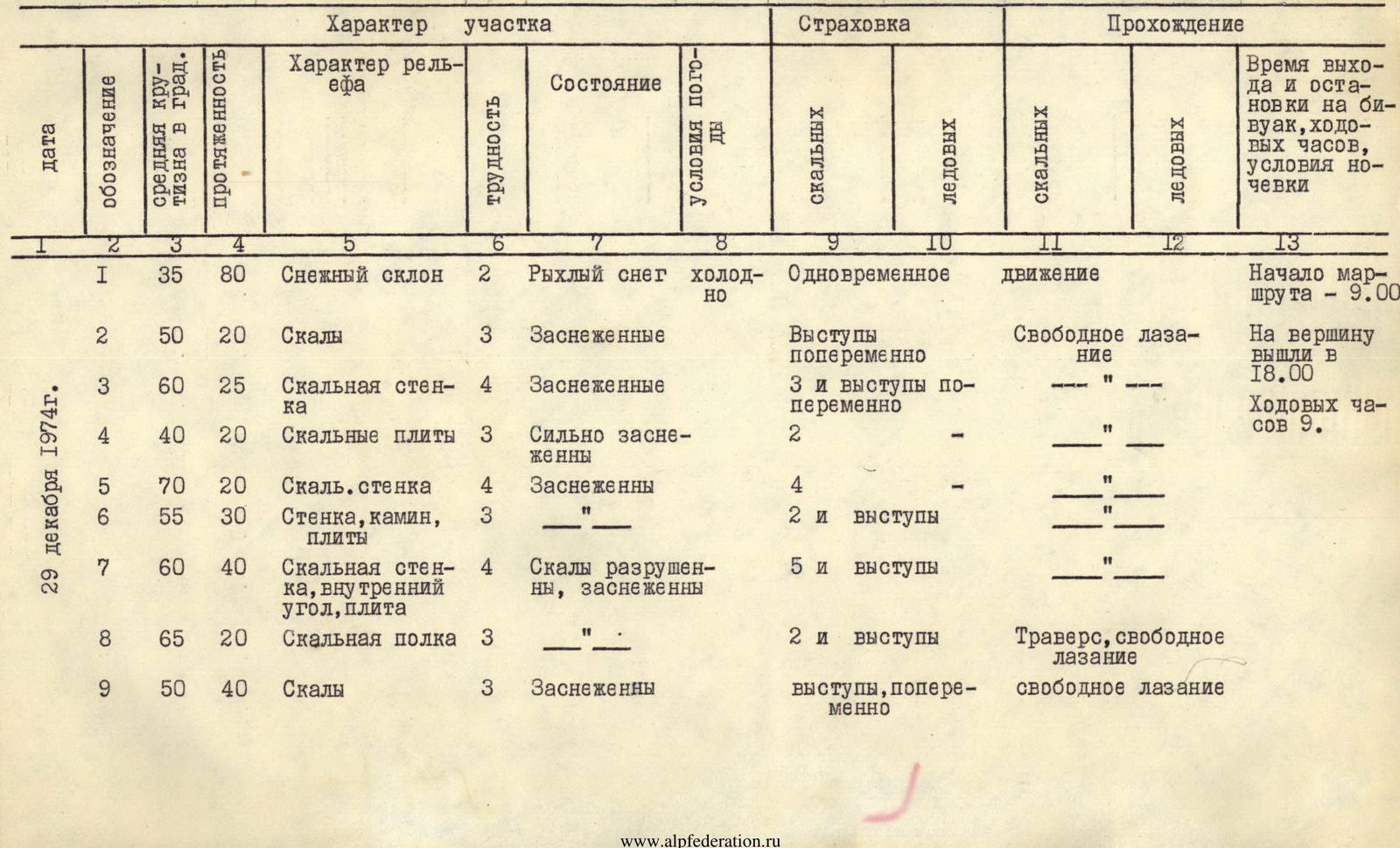
| Date | Designation | Average steepness in degrees | Length | Character of relief | Difficulty | Condition | Weather conditions | Belaying | Passage | Time of departure and bivouac, climbing hours, overnight conditions |
|---|---|---|---|---|---|---|---|---|---|---|
| Rock | Ice | Rock | ||||||||
| 1 | 35 | 80 | Snow slope | 2 | Loose snow | cold | Simultaneous | movement | ||
| December 29 | 2 | 50 | 20 | Rocks | 3 | Snow-covered | Belaying on ledges alternately | Free climbing | ||
| 1974 | 3 | 60 | 25 | Rock wall | 4 | Snow-covered | 3 and belaying on ledges alternately | " | ||
| 4 | 40 | 20 | Rock slabs | 3 | Heavily snow-covered | 2 | " | |||
| 5 | 70 | 20 | Rock wall | 4 | Snow-covered | 4 | " | |||
| 6 | 55 | 30 | Wall, chimney, slabs | 3 | " | 2 and belaying on ledges | " | |||
| 7 | 60 | 40 | Rock wall, inner corner, slab | 4 | Rocks destroyed, snow-covered | 5 and belaying on ledges | " | |||
| 8 | 65 | 20 | Rock ledge | 3 | " | 2 and belaying on ledges | Traverse, free climbing | |||
| 9 | 50 | 40 | Rocks | 3 | Snow-covered | Ledges, alternately | Free climbing | |||
| R0 | 45 | 150 | Snow slope with rock islands | 3 | Under snow — ice | Ledges, belaying via ice axe | Simultaneously | |||
| R1 | 50 | 80 | Rocks, slabs | 3 | Destroyed, snow-covered | 2 and belaying on ledges | Free climbing | |||
| R2 | 60 | 70 | Sharp rocky ridge | 4 | Heavily snow-covered | 5 and belaying on ledges | " |
TEAM CAPTAIN (signature) =K. VALIEV= TEAM COACH (signature) =E. ILYINSKY=
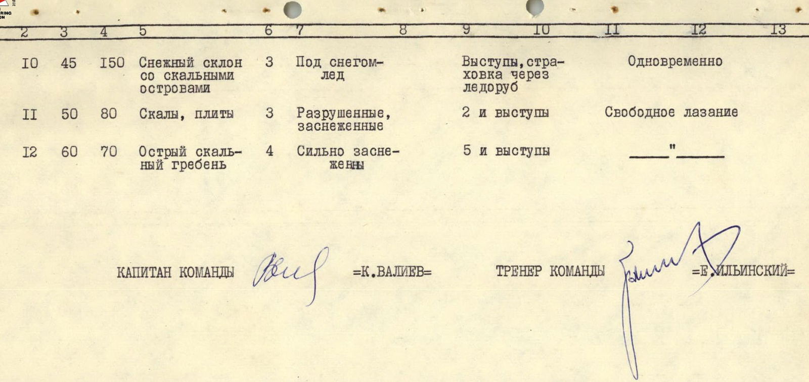 Map of the area around Peak Bogdanovich.
- Chimbulak hostel
- Chimbulak village
- Talgar Pass
- Shkolnik Peak
- Chkalov Peak
- Fizkulturnik Peak
- Tuyuk-Su tourist base
- Abay Pass
- Bogdanovich Peak
- Abay Peak
- Komsomol Peak
- Karly-Tau Peak
- Aristov Peak
- 28 Panfilov Guardsmen Peak
- Pioneer Peak
- Teacher Peak
- Amangeldy Peak
- Pioneer Pass
- M. Mametova Pass
- Myndzhilki meteo station
- M. Mametova Peak
- M. Mametova Peak
- Antikainen Peak
BRIEF EXPLANATION FOR THE TABLE
The ascent area belongs to the Bogdanovich glacier cirque in Trans-Ili Alatau and is located a few hours' walk from the Chimbulak hostel and the Medeo — Myndzhilki road. The approach paths to the start of the ascent route go from the Chimbulak hostel through Talgar Pass, as well as from the Tuyuk-Su tourist base through Abay Pass to the upper reaches of the Bogdanovich glacier (see map).
Peak Amangeldy is located in the upper reaches of the Bogdanovich glacier cirque, in the ridge between Pioneer Peak and Abay Peak. During the ascent to Pioneer Peak 3B category of difficulty (from the north), Komsomol Peak 3B, 4A, and Amangeldy Peak 2B, reconnaissance, photography, and observation of the route were carried out.
The north wall of Peak Amangeldy is cut by a steep, wide snowy couloir. The left wall of the couloir is a powerful rocky rib leading to the summit of Peak Amangeldy. This rib was chosen as the ascent route.
On December 29, 1974, at 5:00, the group left the Chimbulak hostel and through Talgar Pass, along the moraines of the Bogdanovich glacier, approached the north wall of Peak Amangeldy at 8:20 (see photo No. 1).
At 9:00, the group began to ascend the route. Section 1 — a snow slope with a steepness of 35° — the group overcame by moving simultaneously.
Section 2 — further on, steep, heavily snow-covered rocks of medium difficulty, which we overcame with belaying on ledges (photo 3).
Section 3 — the steepness of the rocks increased to 60°. The lead climber constantly clears the rocks of snow. A diagonal ascent to the left leads to a snowy saddle of the rib. For belaying on this section, 3 rock pitons were hammered, and ledges were also used (photo 4). Section 4 — rock slabs are covered with a dense crust of snow up to 30 cm thick. Breaking through the dense snow, belaying on pitons and rare ledges, we reached a ledge under the wall. The left part of the wall is composed of destroyed light-brown rocks, and the right part, beyond the wall's bend, is made of black rocks.
Section 5 — we chose the right part of the wall for the ascent (photo 5). Steepness 70°. This section is climbed with piton belaying. The rocks of the wall are lightly covered with snow. The first climber's belay is only from the ledge at the wall's bend. It is not safe to stay under the wall due to possible rockfall. The top of the wall is a small saddle of the rib. Here is the first control tower.
Section 6 — from the saddle, along a steep slab with few holds, we approached a three-meter wall with a crack. After this wall, there is a gentle, destroyed chimney leading up to the right along a steep rocky wall. Belaying is done with pitons and on ledges.
Section 7 — steep rocks. The lower half is heavily destroyed. The ascent is up a crack, then along an inner corner. In the upper part of the section — slabs (photo 6).
Section 8 — further, a traverse to the left along a narrow ledge (rocks are difficult, with a steepness of up to 65°). The ledge leads to snow-covered rocks of the rib.
Section 9 — ascent along heavily snow-covered rocks to the right, with an exit to the ridge. Belaying is done on ledges.
R0 section — the steepness of the section is 45°, length 150 m. Belaying on rock ledges, we pass along the right edge of the snowy "plateau" under the rocky rib. From it, we move left along the boundary between snow and rocks to the rusty slabs. R1 section — to the left of the rusty slabs, along rocks of medium difficulty, we ascend to under a large black ledge of the ridge "rock". The rocks are heavily destroyed, covered with a crust of snow. Belaying is done on ledges and pitons. Under the "rock" — steep, snow-covered slabs. Here is a belay station.
R2 section — bypassing the "rock" to the left, we reached a sharp, steep pre-summit ridge (see photo 3). Here is the second control tower. Further along the ridge are complex, snow-covered rocks. Belaying is done with pitons and on ledges. The ridge ends with a sharp, three-meter "tooth". From the "tooth" to the summit, the ridge is equally sharp but gradually becomes less steep.
The group reached the summit at 18:00. The descent from the summit via the 1B category of difficulty route took 1 hour.
The route was completed by a group of five people in nine climbing hours.
On the route:
- 25 rock pitons were hammered.
The north wall of Peak Amangeldy is almost not illuminated by the sun (only from 9:00 to 10:00), see photo No. 1.
The ascent was made in winter, which explains the heavy snow cover on the rocks. There are no convenient sites for overnight stays. A tent-pamirka can be set up with difficulty in the area of sections R9–R10. Steep walls on the route alternate with more gentle sections, but even on the latter, careful, alternate belaying is necessary. Significant difficulties on the route taken are encountered both in the lower and upper parts. If we compare the route taken with known routes in the area, we can say that it is longer and technically more complex than the route along the west wall of Peak Mayakovsky 3B category of difficulty, as well as the north ridge of Komsomol Peak 3B category of difficulty.
The average steepness of the route taken is somewhat less than the southwest wall of Komsomol Peak 4A category of difficulty.
The route along the west wall of Peak Mayakovsky 4B category of difficulty has greater steepness and more complex key sections than the route along the north wall of Peak Amangeldy.
Conclusion: the group believes that the route taken can be assessed as not less than 4A category of difficulty.
For compiling a full description of the route taken, photographs were obtained during a repeated ascent made in May 1977 (photos 3–6) by the group of Prudanov A.I. + 4.
This group believes that the route in warm weather can be assessed as not less than 3B category of difficulty.


